The Kurgan region is located in the basin of the Tobol and Iset rivers in the Ural Federal District. There are many rivers and streams flowing through the region, and there are a large number of beautiful lakes, some of which contain healing mineral waters.
The Kurgan region does not have many historical attractions, but it is famous for its natural monuments of regional significance (84), zoological reserves (16) and simply beautiful places.
Kurgan region: TOP 3 places to go right away
The visiting card of the Kurgan region is health resorts and mysterious ancient monuments. We have placed them in the “Main Attractions” section.
Bear Lake
- Coordinates on the map: 55.199537, 67.997895.
Medvezhye is a salt lake in the Petukhovsky district near the border with Kazakhstan and one of the best resorts in the region. The pond is shallow, so children can swim in it safely. The maximum depth does not exceed 1.2 meters.
The waters are so saturated with salt that they easily float even large adults. In terms of its characteristics, the reservoir is comparable to the Dead Sea. In the middle of the lake, six islands protrude from the water.
In summer, the pond is filled with salted brine shrimp - tiny crustaceans that turn the water brown and secrete a special enzyme that calms the nervous system.
Artemia are the only creatures capable of living in such an environment; neither fish nor algae can withstand such salty water. Silt has healing properties and is used in the treatment of many diseases. A health resort has been operating on the northern shore for many years.
Shadrinsky mineral waters
- Address: Shadrinsky district, Verkhnyaya Polevaya village, Sovkhoznaya street, 11.
In the vicinity of the city of Shadrinsk there are several mineral springs, famous for their bottled water “Shadrinskaya”. Geologists discovered the priceless deposit in 1970. Scientists and workers were looking for ordinary fresh water to supply the city, but accidentally discovered a real natural treasure.
In 1984, Shadri residents began bottling water. One of the wells was equipped for the city food processing plant, the second for the Zhemchuzhina Zauralya sanatorium.
Over the course of several years, specialists drilled about 30 wells. Shadrinskaya mineral water, which contains more than 20 useful substances, is compared with Borjomi and Essentuki.
The village of Verkhnyaya Polevaya also has a hot mineral spring. The temperature there stays at 33°C all year round. Water is supplied to swimming pools with hydromassage units.
Savin Sanctuary
- GPS coordinates: 55.698253, 65.644588.
Near the village of Buzan, on a small hill lies the main archaeological pride of the Kurgan region. The unusual ruins are the remains of an observatory sanctuary, in which ancient people performed religious rituals and observed the heavenly bodies. In the spring, during high water, the river floods at the foot of the hill, perhaps that is why the area is called Savin in Ugric, which translated into Russian means “hill among the swamps.”
The archeological monument was opened in 1982 by local resident Vasily Babushkin. Vasily Pavlovich collected several ancient artifacts and donated them to the local history museum. Experts became interested in the finds, conducted a series of excavations near the village and discovered two adjacent circles that looked like a huge figure eight.
Nearby they found more than a hundred holes left from pillars and three human graves. Archaeologists also found traces of fireplaces and pits with sacrifices, which contained fragments of ceramics, items made from various materials and animal bones. Scientists managed to collect more than 7,000 objects.
The sanctuary was built in the Eneolithic era, that is, more than 4000 years ago, the structure is 1000 years older than the famous Arkaim. The observatory was nicknamed “Kurgan Stonehenge”, while the Russian landmark appeared much earlier than the British one. In the vicinity there are three more archaeological monuments: Savin-2, the Slobodchiki-1 sanctuary and the Okhotino-1 settlement.
Longest relay swim
It must be said that this unique event for Russia is the merit of not only the Kurgan , but also the Tyumen region - after all, this record covered both regions. The event took place as an environmental expedition “ Swim along the Tobol River. From the Tsar’s settlement to the Tobolsk Kremlin ”, to attract attention to which the organizers decided to set several records.
Photo source: Royal Mile
The first record that the organizers wanted to set was to make the most massive relay swim. However, the expedition members were unable to achieve this. Although 150 people took part in the swim, much fewer people were in the water at the same time, and throughout the entire swim there were only 3 people in the water.
But the second record - the longest relay swim - was still set. As part of the expedition, the participants swam along the Tobol River from Kurgan to Tyumen , which was 730 kilometers. Moreover, the distance was covered in just 15 days, during which the participants collected unique information about the state of water in the Siberian river.
Wildlife sanctuaries and reserves of the Kurgan region
There are no large nature reserves or national parks in the Kurgan region, but several nature reserves of various profiles have been organized on its territory.
Kurgansky reserve
- Coordinates: 54.272580, 63.845148.
The extensive reserve in the Tselinny region was founded in 1985. It covers the Tobol River valley, which is home to rare fauna. The list of protected species includes the lesser goose, muskrat, lynx and other birds, mammals and insects. This is the only place in the region where demoiselle cranes and little bustards are found.
Poachers have reduced the number of wild animals and birds, and many animals are on the verge of extinction. The criminals harmed not only the inhabitants of the protected lands, but also the position of the reserve in the country: in 2022, due to numerous violations, it lost its federal status and was transferred to regional status.
Reserve "Belozersky"
- Address: s. Borovskoye, Belozersky district.
Another famous reserve was organized in 1999 in the Belozersky district on an area of almost 30,000 hectares. Just like Kurgansky, Belozersky is located in the Tobol Valley. The main task of the protected area is to preserve rare game species such as badger, Siberian roe deer, black grouse and elk.
The fauna of the valley of this attraction has not been fully studied; it is known that the river bank is inhabited by at least 30 species of mammals and more than a hundred species of birds. In the reserve it is prohibited to hunt, make fires in dry weather, cut down forests or otherwise harm animals or their habitat.
Proryvinsky Zoological Reserve
- Address: Kazak-Kocherdyk village, Tselinny district.
The Proryvinsky reserve occupies the lands of two districts at once - Zverinogolovsky and Kurtamyshsky. There are many floodplain and mineralized lakes on its territory.
The local flora is characteristic of steppes and forest-steppes; here you can find rare Bierstein tulips, Russian hazel grouse, common lawnweed and other plants.
Experts are trying to preserve populations of rare animals: Russian muskrat, golden eagle, peregrine falcon, white-tailed eagle, Dalmatian pelican and a dozen other species.
Vargashinsky reserve
- Address: Noskovo village, Vargashinsky district.
A large zoological reserve occupies an area of the Vargashinsky district with an area of more than 22,000 hectares. The reserve was established in 1976 to protect endangered species of wild animals inhabiting Lake Manyass, the surrounding swamps and forests.
The list of protected species is impressive: 140 species of birds, 40 species of mammals, 6 species of reptiles and amphibians. The region's largest colonies of black-throated loons and Dalmatian pelicans nest on the territory of Vargashinsky.
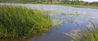
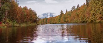
The most beautiful rivers and lakes of the Kurgan region
The territory of the small Kurgan region contains about 3,000 lakes and several large rivers.
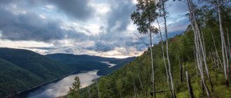
Tobol River
- Coordinates: 55.542218, 65.490077.
The magnificent, full-flowing Tobol River flows through the entire territory of the region - an invaluable gift of nature, which played a huge role in the formation of Kurgan cities and villages.
The river originates in the Orenburg region, crosses the Kostanay region of Kazakhstan, pierces the Kurgan region from southwest to northeast and goes to the Tyumen region, where it flows into the Irtysh.
There are dozens of settlements on the banks of the Tobol, including Kurgan itself. The river is rich in fish, it contains crucian carp, roach, ruffe, carp, perch, pike perch, pike and other species.
Lake Gorkoye-Polovinnoye
- Coordinates: 54.716749, 66.184320.
Bitter-salty lake in the Polovinsky district. The lake received its interesting name for the bitter taste of the water, saturated with minerals.
Centuries ago, a pine forest rustled in its place, but over the years the soil under the trunks collapsed and the trees collapsed into the resulting hole. Springs gushed at the bottom, the depression filled with water, and the pine trees rotted and turned into healing mud. Every half century the lake changes shape and size, sometimes expanding, sometimes narrowing.
In 1985, the reservoir was given the status of a hydrological natural monument. Gorkoye, together with the surrounding forests and steppes, is part of the Zeleny Borok natural monument.
Lake Zverinogolovskoe
- Coordinates: 54.415071, 64.561610.
In addition to the Polovinsky reservoir, in the Kurgan region there are a dozen more lakes with the same name. To distinguish them, the name of the nearest settlement or the entire region is added to the name of the lake.
Thus, the Zverinogolovsky district has its own Gorky Lake. A reservoir resembling a huge horseshoe lies in the vicinity of the village of Iskra. Water with high alkalinity and mud help in the treatment of many diseases, including chronic ones.
Lake Gorkoye-Victoria
- Coordinates: 55.123533, 62.544528.
The drainless lake in the Shchuchansky district is considered the second most popular and important resort reservoir in the region. On its shores in the village of Ozero Resort there is the oldest balneological health resort in the region, founded in 1910.
Currently it is a children's psychoneurological sanatorium. In Gorky there is a thick layer of sulfide silt mud, which, together with water, is used in the treatment and rehabilitation of sick children.
The lake is home to plants typical of salt water bodies and a rare species listed in the Red Book - the sea hornet. The banks are overgrown with reeds and birches. Nearby there is another lake, Gorkoye, with which Gorkoye-Victoria is often confused.
Lake Shamel
- Coordinates: 54.860331, 62.483442.
Safakulevsky district also boasts the presence of a valuable bitter-salty lake. The endorheic reservoir near the village of Martynovka is known by two names – Shamelya and Sulfatnoe.
Rich deposits of healing mud were found in the lake. Due to the high salt content in the water, the lake does not freeze even in the most severe frosts. The reservoir contains only Artemia crustaceans, which the famous traveler Peter Pallas called “scarlet water worms.” There are no sanatoriums or recreation centers on the banks of Shamel, but it is popular among vacationers.
It is important to remember: in case of some diseases, swimming in salt water is dangerous to health, but even in the absence of contraindications, you cannot stay in the lake without breaks for more than 20 minutes.
Parks, gardens, tracts of the Kurgan region
Among Kurgan’s natural monuments, forests and parks occupy a special place, where you can take a walk with the whole family, admiring rare plants and centuries-old trees.
Prosvetsky Arboretum
- Address: pos. Stary Prosvet, Ketovsky district.
There is a small arboretum in the Ketovskaya district. The area of the natural monument is about 10 hectares. The history of the arboretum began in 1893, when the Forest School opened in Kurgan. The following year, a forest nursery was founded, in which practical classes were held for students.
The idea for the nursery was proposed by local forester Viktor Engelfeld. The teachers imported various exotic plants from other provinces and countries and, together with their students, grew them in the arboretum. Initially, the nursery was called “Steep Log”, until in 1898 one of the teachers, Alexander Naumov, proposed renaming it “Lesnoy Prosvet”.
In 2001, the unique collection of plants received the status of a natural monument. In 2010, the Forest Museum was opened in the village of Stary Prosvet on the basis of the arboretum. There are several recreation centers in the surrounding area.
Cedar Garden
- Coordinates: 55.339653, 64.446830.
On the outskirts of the village of Razdolnaya there grows a wonderful coniferous garden, filling the entire area with aroma. The garden was founded by local resident Trifon Plotnikov in 1980. Trifon Matveevich planted Siberian spruce and Siberian pine, which are atypical for the Trans-Urals.
Cedars have successfully taken root on Kurgan soil and to this day delight guests and village residents. In 2011, the garden received the status of a natural monument of regional significance.
Elizavetinsky Bor
- Address: Yurgamysh district, village. Elizabeth.
The pine and birch forest near the village of Elizavetinka is one of the oldest in the region. Many trees celebrated their 100th anniversary, and some specimens have lived for 170 years.
At the foot of the pines grow a variety of shrubs: black cotoneaster, blood-red hawthorn, rosehip and many others. Among the thorny beauties there gurgles a spring, consecrated in honor of the martyr John the Warrior.
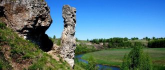
"Okhoniny Brovi" tract
- Coordinates: 56.274767, 62.352517.
On the banks of the Sinara River there is a beautiful tract with an unusual name - Okhoniny Brovi. Local residents nicknamed the two coastal bends eyebrows. The river eroded the ledges and exposed layers of marl and diatomite.
The slopes are covered with small-leaved forest; among the plants there are petrophytes, rare for the Trans-Urals, growing on stones and rocks. The tract is beautiful at any time of the year, and therefore is popular with tourists.
Landscape park
- Address: working village Kargapolye, st. Mira.
The park in the village of Kargapolye can be called the most unusual park in the Kurgan region. The area was developed in 2004, the grand opening of the attraction was timed to coincide with the 80th anniversary of the Kargapol district.
The area has green lawns, colorful flower beds, pyramidal poplars rustling in the wind, pine trees and blue spruce trees.
Workers created several small ponds, a waterfall fountain and a colorful stone bridge. Whole families walk in the park; it has playgrounds with attractions and entertainment for adults.
Kurgan region: springs and waterfalls
Lakes and mineral wells are not the only water attractions in the region. In the area you can find revered holy springs and small artificial waterfalls.
Chimeevsky holy spring
- Coordinates: 56.106111, 65.148250.
In the village of Chimeevo, not far from the ancient wooden church, a revered spring flows. Pure cold spring water contains a large number of silver ions, so it has healing properties and does not spoil for a long time.
The source, like the temple, was consecrated in honor of the Kazan Icon of the Blessed Virgin Mary. Pilgrims have been going to the spring since ancient times. In Soviet times, officials tried to destroy the shrine; they covered the key with earth and organized a landfill in its place.
In 1979, villagers dug up a spring and gradually cleaned and landscaped the area. The spring is located in a picturesque pine forest, a neat wooden bridge leads to it, beautiful wells and a large chapel-bath were built above the spring.
Erokhinskie kneaders
- Coordinates: 55.239250, 64.647723.
Near the village of Erokhin, Yurgamysh district, you can admire a unique landmark of the region - dozens of mud wells. The grey-green bubbling mud resembles dough, which is why local residents nicknamed the wells kvass.
Sometimes yellow or blue liquid splashes out of bottomless pits onto the surface of the earth. In 1936, mud volcanoes woke up and threw a fountain of dirty water into the air for about two hours.
It is best to visit this unusual place in the spring before the heat sets in, which sometimes dries out the pits, turning them into yellow circles. Tourists should keep a safe distance from volcanoes so as not to get stuck in them: liquid mud sucks in like a quagmire.
Baskazyk waterfall
- Coordinates: 55.901768, 62.628632.
Waterfalls are a rarity for the Kurgan region. Almost all attractions of this kind were created artificially. One of the most famous examples is the waterfall on the Baskazyk River near the village of Verkhnyaya Techa.
The waterfall appeared after the construction of the dam and has been delighting guests of the area ever since. River waters fall from a height of 5 meters and rush further in a foamy stream. You can often see fishermen near the dam.
Shironinskaya mill
- Coordinates: 54.922472, 64.982883.
A few kilometers from the village of Glyadinskoye on the Tobol River there is a low, but very wide and picturesque artificial waterfall. The river flow falls like a sparkling curtain from the dam and noisily crashes into large stone boulders.
In summer, the area near the waterfall is especially crowded; many people come here to swim and sunbathe. Vacationers put their backs under the stream of water and treat themselves to free hydromassage sessions.
Utyaksky waterfall
- Coordinates: 55.274594, 65.343276.
Another famous artificial waterfall in Kurgan was created on the Utyak River during the construction of a dam in the village of Balki. In the spring the stream is stormy and noisy, but in the summer it becomes low-water and exposes concrete piles.
Some tourists manage to climb under the dam and admire the attraction from the other side. In winter, the waterfall freezes, turning into spectacular greenish blocks of ice.
Travel tips
Kurgan is worth visiting in the warm season - from May to September. Although in mid-summer it is quite hot here, so tourists who do not like heat should come in May or early autumn. In winter, the city is quite cold and windy.
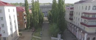
You can explore the main attractions of Kurgan in one or two days. All of them are located in the central part of the city, so the excursion will be quite compact. In addition, most hotels are also located in close proximity to the city center, so you can move around Kurgan on foot. Public transport here is not very developed - it is represented only by minibuses, however, they can easily take you anywhere in the city.
You can buy locally produced birch bark products in souvenir shops in the city.
There are no special souvenir products in Kurgan. Most often, travelers purchase birch bark products as gifts for loved ones. The choice is quite large, you can find everything from magnets to flasks.
Kurgan archeological and architectural monuments
People inhabited the territory of the modern Kurgan region about 20,000 years ago. Scientists to this day find objects and structures from different historical eras in the Kurgan land.
Tsarev Kurgan
- Address: Kurgan, Energy district.
In the very heart of the region, in the vicinity of the city of Kurgan, stretches a chain of ancient burial mounds from the Bronze and Iron Ages. The largest conical-shaped burial mound gave its name to the settlement, and now to the regional center.
According to legend, the daughter of a certain Siberian khan rested in the Tsarev Kurgan, but historians have not found evidence for this version. In the 18th century, a provincial official ordered the mound to be opened in the hope of finding treasure. Workers began excavations at the top of the hill, found nothing, but ruined the appearance of the mound.
Over time, the ugly pit left over from the search was filled up, the site was leveled, decorated with a gazebo, and the mythical treasures were forgotten for a long time. Only tomb robbers periodically dug into the hills and found ancient artifacts.
In 1893, scientists got down to business. Archaeologist Axel Geikel, together with his assistants, opened two neighboring mounds and collected a collection of artifacts. In Soviet times, an expedition from the Ural University conducted the first full-fledged excavations of the Tsarev Kurgan.
Scientists discovered a wooden flooring over the tomb, fragments of tools, fragments of dishes and many other objects. In subsequent years, builders almost completely destroyed the mounds. In 2013, the Tsarevo Settlement Park was opened in their place.
Pure Swan burial grounds
- Coordinates: Chistolebyazhye village, Belozersky district.
The tiny village of Chistolebyazhye has long been abandoned and is of interest only to archaeologists and history buffs. Three burial grounds were found in the vicinity of the settlement. The oldest was created in the second millennium BC. e., the other two - in the period from the 8th century BC. e. to 3rd century AD e.
Excavations of the necropolis began in the 1970s, the first researcher of archaeological sites was V. A. Mogilnikov. In addition to human graves, scientists discovered animal burials, traces of ritual fires, stone arrowheads, clay vessels, bronze beads and other objects.
Pany town
- Coordinates: 56.157884, 64.611070.
Murzinskaya Mountain on the banks of the Iset River is popular among athletes and outdoor enthusiasts. In winter, skiers and snowboarders ride on its birch-covered slopes; in summer, young people go on hikes and picnics.
At the top there is a cozy wooden gazebo. Few vacationers know that the small mountain has a long and eventful history. Traces of the Yuda culture were found on the hill - more than 150 dugouts and half-dugouts, a fortress rampart, metal arrowheads and spears, vessels and a burial ground.
The first excavations on the territory of the archaeological monument were carried out back in 1846. Also at the foot of the mountain there are trenches from the Civil War.
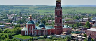
Dalmatovsky Assumption Monastery
- Address: st. Sovetskaya, Dalmatovo.
In the city of Dolmatovo, the oldest Orthodox monastery in the region has been preserved. The monastery was founded in 1644 by the hermit monk Reverend Dalmat; the city was later named after the saint.
Initially, all the buildings were wooden, only half a century later their place was taken by monumental stone structures. Powerful stone walls were worthy of royal fortresses, high spacious churches could accommodate hundreds of believers.
Before the October Revolution, the monastery more than once found itself at the center of important historical events. It became the prototype of the Prokopyevsky Monastery in the story “Okhonin’s Eyebrows” by the famous Russian prose writer D. M. Mamin-Sibiryak. Also, guilty monks or disgraced military men were often exiled here.
After 1917, many inhabitants were repressed, and the monastery became the property of the working people. The temples and towers were partially destroyed and rebuilt, with . The monastery is currently being revived.
Dugouts from WWII
- Address: s. Bolshoye Chausovo, Ketovsky district.
The Kurgan region not only stores artifacts of antiquity, more recent events also left their mark on its land. Thus, in the village of Bolshoye Chausovo, dugouts built during the Great Patriotic War have survived. They were dug by soldiers of the tank school, which was evacuated from Stalingrad in 1942.
In a matter of days, the military created many temporary shelters with log ceilings and dirt floors. Local residents cherish the buildings as a memory of the terrible war and the defenders of the Motherland who died on the battlefields.
The largest human figures in Russia
In the city of Shadrinsk, Kurgan region, Russian records were set at once .
Photo source: Russian Book of Records
The first was staged in 2013 and dedicated to the centenary of the pedagogy of Maria Montessori in Russia . On this day, teachers decided to hold the “Learning with Pleasure” campaign, in which eight cities took part - St. Petersburg , Yekaterinburg , Tomsk , Chelyabinsk , Shadrinsk , Odintsovo , Surgut and Novosibirsk . On this day, children, parents and kindergarten teachers, as well as students and teachers of the Shadrinsk Institute and College lined up in one big smiling face.
In total, 345 people took part in creating the emoticon, thanks to which the city was included in the Russian Book of Records for the emoticon consisting of the largest number of people. However, the Shadrinians are still far from the world record set in the Philippines - in 2015 they made a smiley face from more than 8 thousand people.
Photo source: Russian Book of Records
A couple of months later, a second mass record was set in Shadrinsk - this time the townspeople lined up in the shape of a heart. 242 people took part in the flash mob, which, although it became a record in Russia , does not reach the world level, where more than 11 thousand people depicted a heart.
What else you need to see in the Kurgan region
Curious tourists will find several more beautiful places in the Kurgan region with an interesting history.
Siberian tract
- Address: Chineevo village, Yurgamysh district.
The route from Moscow to China, which went down in history, passed through the Trans-Urals, including through the modern Kurgan region. Many settlements were founded on the ancient highway, many of which appeared precisely thanks to the famous route. Travelers, traders and convicts walked through the Kurgan land.
Traces of the old road, trampled by tens of thousands of feet, can be seen in some Kurgan villages and hamlets, for example, in the villages of Eloshnoye and Chineevo. In the latter, a sign “Siberian Tract” was installed several years ago.
Geoglyph “Lenin 100 years old”
- Coordinates: 54.467738, 64.797671.
Between the villages of Trud and Znanie and Zverinogolovskoye is located one of the best-preserved geoglyphs of the Soviet era. An unusual planting in the form of the phrase “Lenin is 100 years old” appeared in 1970 in honor of the centenary of the country’s main revolutionary. More than 40,000 seedlings were used to create the giant inscription, which is 600 meters long.
Unfortunately, the scale and detail of the work done can only be fully appreciated from a great height or from photographs. The geoglyph is in excellent condition to this day, every letter is clear, not a single extra tree interferes with reading the inscription.
Miracle tree
- Coordinates: 54.395044, 64.581324.
In the Ozerninsky forest, which grows on the shores of Lake Gorkoye, one curious tree stands out among thousands of pines. A small spreading pine is the oldest “inhabitant” of the forest; its age is close to 200 years.
The old coniferous woman is smaller in size than her young, slender neighbors; her height does not exceed 20 meters. The gift of nature is included in the register of old-growth trees in Russia and is protected by the state.
Ivanov Stone
- Coordinates: 56.217233, 62.102167.
The natural monument Ivanov Kamen is a unique rock outcrop on the surface of the earth for the region. The protected area includes a slope of the Sinara River approximately 40 meters high, forests, logs and quartz porphyry boulders.
The largest block of rock, 50 meters long and 20 meters high, was named Ivanov Stone. The rock overgrown with colorful lichens is often used as an observation deck to view the surrounding area. You can find beautiful stones around; at the foot of the trees you can find jasper, agate, chalcedony, amethyst and carnelian.
The flora of this attraction is no less diverse and interesting; mountain plants such as white lupine and rock fern are found here. 33 plant species are listed in the Red Book.
Belozersk ecological trail
- Coordinates: 55.797234, 65.779304.
A convenient and interesting tourist route was laid out several years ago in the Belozersky district on the territory of a local nature reserve. A walking tour of the natural resources and attractions of this place lasts 2-2.5 hours.
During this time, tourists can explore all 26 attractions along the trail. Most of the objects are feeders for animals: salt licks for ungulates and hares, tables for upland game and others. If you are lucky, you can meet the wild inhabitants of the reserve.
You may be interested in the sights of the regions of the Russian Federation neighboring the Kurgan region - Chelyabinsk, Sverdlovsk and Tyumen regions
The attractions of the Kurgan region bring many benefits to tourists: some are good for recreation and entertainment, others for self-education, and others help improve health. Traveling through this wonderful southeastern region can give not only vivid impressions and new knowledge, but also good health.
How to stay in touch
Our pages and communities on social networks and services.
An option is sending by email.
The rights to published materials, as well as to individual elements of the site design, belong to their authors and are protected by the Civil Code of Russia © 2011–2020.
The founder and director of Uraloved is Pavel Raspopov. Project email
“Uraloved” is developing with the support of caring and interested participants and benefactors.
Noticed a mistake? Select the text with the mouse and press Ctrl Enter.
Source