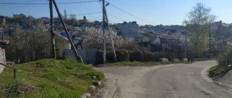
Vyatka, as the Kirov region is often called, is one of the most cozy provincial regions of Russia. There are ancient settlements, Orthodox shrines, and magical lakes here. Local residents are still engaged in folk crafts today, covering toys with the famous Dymkovo painting and carving nesting dolls, weaving bast shoes and composing legends about mysterious places. And the natural attractions of the Kirov region cause genuine delight and surprise, because such wonderful places as on Vyatka land are still worth finding.
Natural monuments of the Kirov Region
The most numerous specially protected natural areas in the Kirov region are natural monuments - these are unique, irreplaceable, ecologically, scientifically, culturally and aesthetically valuable natural complexes, as well as objects of natural and artificial origin.
Depending on the object of protection, the following types of natural monuments of regional significance are distinguished:
- landscape (including protected areas);
- geological and paleontological;
- geomorphological (orographic);
- hydrological;
- biological;
- natural-historical (including religious);
- complex.
Natural complexes and objects can be declared natural monuments, including:
- scenic areas;
- reference areas of untouched nature;
- areas with a predominance of cultural landscape (ancient parks, alleys, canals, ancient mines, etc.);
- places of growth and habitat of valuable, relict, small, rare and endangered species of plants and animals, including at the borders of their ranges;
- forest areas and forest areas that are especially valuable for their characteristics (species composition, productivity, genetic qualities, planting structure, etc.), as well as examples of outstanding achievements of forestry science and practice;
- small dendrological parks;
- natural objects that play an important role in maintaining the hydrological regime;
- unique landforms and associated landscapes (groups of rocks, moraine-boulder ridges, karst caves, etc.);
- geological outcrops of scientific value (reference sections, stratotypes, outcrops of rare minerals, rocks and minerals, known in an extremely limited number);
- geological and geographical polygons, including classic areas with especially expressive traces of seismic phenomena;
- locations of rare or particularly valuable paleontological objects;
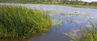
- sections of rivers, lakes, wetland complexes, small rivers with floodplains, lakes and ponds;
- natural hydromineral complexes;
- mineral springs, deposits of medicinal mud;
- coastal objects (spits, isthmuses, peninsulas, islands, bays, lagoons, etc.);
- individual objects of living and inanimate nature (bird nesting sites, long-lived trees and trees of historical and memorial significance, plants of bizarre shapes, single specimens of exotics and relics, volcanoes, hills, boulders, waterfalls, springs, river sources, manifestations of karst, caves , grottoes, etc.).
Natural monuments can be identified within the boundaries of state nature reserves, natural parks and health-improving areas.
173 natural monuments of regional significance on the territory of the Kirov region
. The following are some famous natural monuments of the Kirov region:
— “Kotelnich locality of pareiasaurs”
, created in order to preserve the unique location of rare paleontological objects from the Permian period of the Paleozoic era (about 255 million years ago). The fossil fauna of the Kotelnichsky locality includes about 20 species of ancient reptiles and amphibians. The natural monument is located in the outskirts of the city of Kotelnich, starting from the city’s cargo port, 0.5 km below the railway bridge over the river. Vyatka and extends to the village of Volki, located 20 km south of the city.
— “Vicinities of the village of Ryabovo” in the Zuevsky district
, created in order to preserve the natural-historical complex, which includes the Vasnetsov estate in the village of Ryabovo and the surrounding territory.
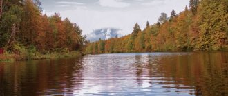
— “Lake Lezhninskoye” in Pizhansky district
- the deepest karst lake in the Kirov region. The depth of the lake is more than 30 m, the mirror area is 4 hectares, the protected area is 49.64 hectares. The natural monument has scientific, educational, environmental significance and is a place of mass recreation for the population.
— Natural complex “Christophorov swamps” (Luzsky district)
created to preserve a site of relict old-growth oxalis and fern spruce forests with linden in the undergrowth and a wetland complex, which is the habitat and growth of plant and animal species listed in the Red Book of the Russian Federation and the Red Book of the Kirov Region.
— "Zaramenskaya Cave"
- a geological natural monument with an area of 14.96 hectares - created to protect the karst grotto, demonstrating an example of the corrosion-erosion form of the relief and exposure of limestones of the Kazan stage of the Permian system. The natural monument has scientific and educational significance.
— "Arboretum of foresters of the Kirov region"
created in order to preserve a specialized collection of trees and shrubs with the possibility of using various species for ornamental gardening and landscape design.
The natural monument is located in the settlement of Lyangasy, Novovyatsky district of the city of Kirov
. The area of the natural monument according to the territorial land management project for the land plot within the boundaries of the specially protected natural area is 49.44 hectares.
On the territory of natural monuments and within the boundaries of their protective zones, any activity that entails a violation of the preservation of natural monuments is prohibited. Owners, possessors and users of land plots on which natural monuments are located undertake obligations to ensure a regime of special protection of natural monuments.
Mountains, rocks and caves of the Kirov region
It is believed that the relief of the Kirov region is not diverse. However, there are also mountains and caves. Moreover, the processes of their formation did not end many centuries ago. They continue in our time, creating new amazing objects.
Remnant Sentinel
- Coordinates: 57.426111, 48.939480.
The rock with this name is located on the territory of the Chimbulat botanical-geological complex. This is an 8-meter remnant of a limestone massif. It is included in all excursion routes and is extremely popular among tourists.
Many take photos next to him against the backdrop of the picturesque surroundings. And some even try to climb right onto it. True, no one has ever succeeded in doing this. Next to the outcrop there is another interesting rock - Chimbulat, where you can see a stern male face.
Zaramenskaya Cave
- Coordinates: 57.541853, 48.938562.
The cave near the village of Zaramenye is the most famous in the Kirov region. And for a long time she was the only one. It is a grotto carved into limestone rocks by underground waters. The length of the cave is about 15 m, the rest of the cave is impassable.
Its second name is the Devil's Oven, because the entrance resembles a furnace. In the old days, gangs of robbers hid here, and at the beginning of the 20th century, clayey limestone (opoku) was mined.
Red Mountain near the village of Paska
- Address: Paska village, Kilmez district.
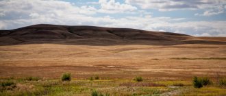
One of the most picturesque places is located in the Kilmez region, on the banks of the river. Lobani. The steep bank, up to 35 m high, is covered with dense mixed forest. From here you have a beautiful view of the river itself and its surroundings. Rare plant species grow on the slopes of the mountain, among which is the Lady's Slipper orchid.
Mukhinskaya Cave
- Address: city of Vyatskie Polyany.
This cave appeared naturally, but was later expanded by people. It is assumed that this could have been done by local residents when they explored it in search of cuprous sandstone.
The entrance to it is located on the rocky shore of Vyatka near the town of Vyatskie Polyany, at an altitude of 13 m. Therefore, it is not so easy to find it. The cave itself is a small grotto, which can only be reached by crawling or on all fours through a very low hole.
Boom Mountain
- Address: pos. Pervomaisky, Slobodskoy district.
A high 30-meter hill on the bank of the Vyatka in the village of Pervomaisky has long been considered a place of power. This is an ancient mound. Previously, there was a wooden church on its top, destroyed during Soviet times. Now only an Orthodox cross and a sign remain, saying that temples have always stood in this place and the ancestors of the Vyatichi people prayed.
There are many legends and rumors associated with the hill. For example, that it was here that the mythical Chud people hid in the 16th century. The name of the hill is also associated with popular belief. It’s as if the hill is empty inside and if you hit it, you can hear a rumble.
Medvedsky Bor (Nolinsky district)
This is a relict pine forest on sand dunes with the presence of forest-steppe animal species (tarantula, antlion) and more than 30 species of steppe plants (feather grass, paniculata, sand clove). Here you can find lilies of the valley, lungwort, and corydalis. In summer - the kingdom of strawberries and mushrooms.
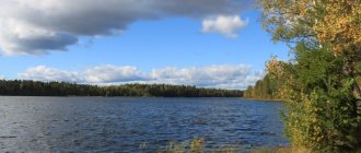
The karst relief of the forest is clearly expressed: there are many sinkholes, sinkholes, and lakes.
This picturesque karst lake is formed by twenty merged karst sinkholes, hence its second name - Provaly.
The length of the lake is more than a kilometer, width from 50 to 120 meters, depth up to 14 meters. The water is amazingly clear, the bottom is sandy.
Tourist complex "Poroshino"
An excellent option for winter events. You can celebrate the New Year holidays at the local camp site or come here for Maslenitsa. There are ski slopes here, and festivals and sports competitions take place here.
When visiting Poroshino, you should only take a good mood and warm clothes with you. The complex provides all sports equipment for rent
However, there is something to do here in the summer. Tourists can enjoy horseback riding and well-maintained walking eco-routes.
Tourist complex "Poroshino"
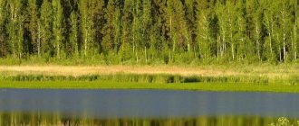
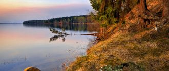
Bykovshchinskoye Lake (Black) (Sovetsky district)
Protochnoe, a spring flows in, and the Maslenka River flows out. Depth – 12 m. It has an oval shape with a length of 280 m and an average width of 140 m.
In the morning hours, a multi-meter thick layer of white fog oscillates over the water surface. Gradually it evaporates. A light breeze drives water vapor to one shore. But the dense wall of the forest turns him back. In the middle of the lake, the streams collide and a high column of water vapor rises.
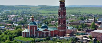
Velikoretskoe
The village is famous for the Velikoretsky Castle, a vast temple complex from which the religious procession begins on Orthodox holidays. The cathedral complex includes several churches, the Nikolo-Velikoretsky Monastery , a chapel, a bell tower and shopping arcades. All buildings date back to the 18th-19th centuries.
Velikoretskoye is also known for its picturesque natural monuments.
Velikoretskoe
Rare plants growing in the Sovetsky region, including on the rocks
Named after the now defunct village of Beresnyata. The total height of the waterfall is 25m. It consists of 6 ledges, with a height of 1 m, 2.5 m, 1.5 m, 2.5 m, 4 m, 7.5 m.
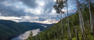
Suvodsky Bor (Sovetsky district)
The picturesque pine forest, located on the left bank of the Vyatka River, lies on sandy hills - ancient dunes formed more than a hundred thousand years ago. Giant larch grows in the forest, which is more than 300 years old. Height 39 m, diameter – 84 cm.
location of the remains of ancient animals (pareiasaurs)
During excavations
Historical landmarks
Each region has attractions that tell its history in detail and in colors, showing the path traveled from antiquity to the present day.
Zhukovlyansky boulders
- Coordinates: 58.304727, 48.018566.
One of the mysteries of the Zhukovlyansky sand quarry is the huge round boulders. Their size reaches 3 m, and their quantity is 1500 pieces. It is still unknown where the stones among the sands came from. There are rumors among the locals that the stones are alive and can breathe. And if you touch them and make a wish, it will definitely come true.
Kovrov settlement
- Coordinates: Kovrovy village, Kotelnichesky district.
An ancient settlement at the mouth of the river. Moloma, not far from the village of Kovrovy, was discovered back in 1881. It is believed that it was one of the first settlements of the Vyatichi. During excavations of the settlement, archaeologists found a conflagration of an ancient Russian dwelling dating back to the 13th century and products from the same period.
In addition, the finds include the remains of an adobe oven, arrowheads, various tools and lead seals. Unfortunately, the archaeological monument is now under threat of destruction due to the proximity of arable land to it.
Pareiasaurus Cemetery
- Address: Kotelnich city.
One of the world's largest cemeteries of ancient pareiasaurs is located in the Kirov region. These ancient lizards are much older than dinosaurs; they went extinct about 250 million years ago under unclear circumstances.
This place is located under Sokolya Mountain, not far from the town of Kotelnich. Here, bones and skulls of fossil reptiles can be found anywhere on the beach. Currently, excavations under Sokolya Mountain are underway, but the excitement caused by the finds is gradually fading.
Istoben settlement
- Coordinates: 58.425827, 48.826946.
Istobensk in the Orichevsky district is a legendary place. Not far from it is the ancient Istoben settlement - a historical and archeological monument of federal significance. The first studies of the ancient settlement were carried out at the end of the 19th century. Thanks to this, the history of the settlement of the Vyatka land by the ancestors of the Mari and Udmurts was studied.
Lake Padun (Verkhnekamsk region)
A round lake with a diameter of 350 meters, a basin of 700 meters, a depth of more than 28 meters (the second deepest lake in the region), at the beginning of the 20th century the deepest lake was 38 meters
rare mineral paint
Museum-estate of A. N. Bakulev
The historical museum of Academician Bakulev, which was opened in the village of Bakuli, Kirov Region in December 1991, is very popular. The museum-estate is located in the house in which the outstanding surgeon, scientist, and public figure Academician A. N. Bakulev was born and spent his childhood.
This place contains collections of crafts and rural household items, things of the Bakulev family, surgical and medical equipment, as well as various documentary materials. On the territory of the estate there are outbuildings, a bathhouse, a mill, an agricultural pavilion and a working forge.
Ukhtymskoe volkonskoite deposit (Bogorodsky district)
That’s what it’s called in Udmurt, but it’s better known as Shaymy. This is a puga (ridge), formed by the Lumpun and Uninka rivers, which came very close to each other, forming this watershed ridge. At the top there is a road from Unei to Porez, on both sides of which there are large sand and gravel quarries. Previously, gravel was mined here. Shaymy is located at a distance of two kilometers from the district center. A deposit of volkonskoite, an excellent natural dye, has been discovered here. Ocher and completely black sandstone, containing up to 54% manganese, are also found here.
Reserve "Nurgush"
The nature reserve consists of two different areas. Crystal clear lakes surrounded by coniferous and mixed forests attract travelers with the opportunity to relax from the bustle of the city in the fresh air.
“Nurgush” offers several ecological excursions , as well as a museum, which includes three halls of different directions.
Reserve "Nurgush"