Famous rivers and lakes of the Vologda region
This region is one of the richest in water resources in Russia. Many of its rivers originate in neighboring regions, others are born here and are included in the list of the most beautiful water areas in the country.
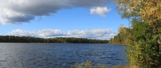
White Lake
- Coordinates on the map: 60.176882, 37.646238.
At dusk, when the stars light up in the sky, or in bad weather, when the sun hides behind lead clouds, the entire surface of the lake begins to glow with phosphorescent light. This effect is produced by fine white clay that rises from the bottom and mixes with water.
Because of this, the lake is called White. Although some linguists believe that its name is a literal translation from the Vepsian language.
This is one of the largest reservoirs not only in the Vologda region, but also in Europe. Its area is almost 1290 square meters. km. The lake has long been famous for its abundance of fish, especially its northern shore: sterlet, sturgeon, roach, pike, bream. Some of them, with the exception of sturgeon, live here and now
Kubenskoye Lake
- GPS coordinates: 59.640575, 39.442751.
One of the most picturesque lakes in the Vologda region is Kubenskoye. About 30 rivers flow into it. One of them is Kubena, after whom he was named. And only Sukhona flows out.
The reservoir is navigable. It is believed that it was precisely this that Peter I initially wanted to use for the construction of his flotilla. But I changed my mind because of the shallow depth. For the same reason, fishing on the lake can only be done from a boat or in the winter when the ice freezes. There is plenty of fish here, especially perch. And there is even nelma, which is very rare in our time. Previously, it was considered a “royal” fish and could only be found on the tables of the nobility.
The lake is also famous for the fact that in the middle of it there is a small island on which the oldest monastery of the Russian North is located - Spaso-Kamenny. The monastery, built in 1260 by Gleb Vasilkovich, was destroyed during Soviet times. But now work is underway to restore the ancient temple. You can get to the island along a narrow embankment or by boat.
For tourists, bases and rest houses, as well as campsites, have been built on the banks of the reservoir. Those who like to relax with savages were less fortunate. Where the coast is not landscaped, everything is overgrown with grass and algae.
Sukhona River
- Coordinates: 60.029490, 43.060438.
“River with a dry bottom” - this is the name given to it by the Slavs who settled on its banks in the 9th century - a historical place. It was known to people back in 17 thousand BC. e., as a place suitable for living. It was here that the Finno-Ugrians and Aryans became related, giving birth to new tribes. Vepsians, Meryas, Komi, Sami, and later Slovenes, the same ones who founded Novgorod.
The largest and most beautiful river in the region has always been mysterious. The nature of its flow is inconsistent; narrowings occur in the lower reaches, and not in the upper reaches, like other rivers. If the current constantly moves in a north-easterly direction, then during a flood it can sharply reverse.
As a tourist attraction, Sukhona will interest any person. Wild beach holidays, visits to boarding houses and tourist centers, fishing spots and hunting grounds - all this is on the banks of the ancient northern river. The bravest ones can try rafting or kayaking along the numerous rapids.
Sitskoye Lake
- Coordinates: 59.824959, 38.870830.
The lake, located near the Russian North park, is loved by both fishermen and tourists. Its shallow depth and powerful channels that prevent the water from blooming make it very attractive for recreation.
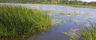
Uloma swamp
- Coordinates: 59.010938, 37.186992.
The reservoir, located on the territory of 4 districts of the Vologda region, is one of the three largest wetland systems in Europe. It was formed approximately 12 thousand years ago as a result of the shallowing of an ancient lake, but swamp-forming processes continue today.
Its development began in the middle of the 20th century. It was assumed that peat would become the main fuel for the Cherepovets State District Power Plant, but it turned out to be unsuitable for combustion. Then it was decided to preserve part of this ecosystem in its original form.
The Uloma swamp is a real book of nature. Here you can find trees, shrubs, grasses and mosses. Many of them, such as English sundew, common water lily, snow-white water lily, etc., are listed in the Red Book of Russia.
Ornithologists also consider it one of the most favorable habitats for waterfowl. The largest population of black-throated geese within the European part of Russia is observed here, as well as peregrine falcons, golden eagles, osprey, golden plover, etc.
Murmansk region | Area 145 thousand square meters. km
The Murmansk region is in ninth place among the largest regions of the Russian state. It occupies an area of 145 thousand square meters. km. — 0.85% of the entire territory of the Russian Federation. The date of its formation is considered to be May 28, 1938. The territory of the subject is home to 762 thousand 173 people, which is a density of 5.26 people/sq. km. About 70% of the area is occupied by the Kola Peninsula. On the territory of the region there is the Baltic crystalline shield, which is a real mineralogical treasury, unparalleled in the world in terms of the diversity of minerals and minerals. Some of them are not found anywhere else.
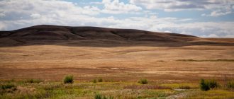
Vologda region: beautiful mountains and rocks
Hilly hills and mountain peaks are one of the features of the relief. Many of them are completely unremarkable, but there are others that amaze with their beauty and unusualness.
Mount Andoma
- Coordinates: 61.282282, 36.365155.
The multi-colored steep slope towering above Lake Onega is one of the most beautiful places in the region. Here sediments that are millions of years old come to the surface: red, green, purple sandstones.
They even contain fossilized trees and ancient fish covered with shells. The mountain is part of the Great Andoma Upland and has a height of 85 m above sea level. It was formed as a result of the movement of a large glacier.
Mount Maura
- Coordinates: 59.866807, 38.278809.
The mountain, unremarkable at first glance, already at the stage of ascent turns into a bastion of tranquility. And at its top, even the most tired traveler begins to feel an extraordinary surge of energy and vigor. It seems that lightness is diffused in the very air around Maura.
This phenomenon is explained by the fact that several water streams intersect at once under the mountain, and such places have always been filled with the energy of life. In addition, this is an excellent observation deck. From the top there is a wonderful view of the Russian North park and the Kirillo-Belozersky Monastery.
Mount Sandyrev
- Coordinates: 59.882586, 38.294504.
Another mountain of the national park is Mount Sandyreva. It differs from other hills in the almost complete absence of vegetation, standing out as a gray spot against the backdrop of a riot of greenery. Thanks to this, the mountain offers wonderful views of all directions. From it you can see the largest islands on Sheksna, the village of Sandyrevo, the village. Goritsy and nearby fields, meadows and forests.
Until 1968, limestone was mined here, as evidenced by two abandoned quarries. Development stopped after Nikolai Barbot de Marny, Doctor of Geological Sciences at the St. Petersburg Mining Institute, compiled a complete description of the unique fossil deposits. Now, due to its conservation status, it is prohibited to conduct any economic activity on the mountain, including grazing.
Mount Malgora
- Coordinates: 60.678056, 35.378611.
The highest point of the Vologda region is located in the Vytegorsky district and has an altitude of 304 m above sea level. This is part of the Vepsian Upland, slightly elongated and consisting of several hills. Its steep slopes are covered with spruce forest. At the foot splashes Malozero with its swampy shores and Malruchey, which received their names from the name of the mountain.
Tomsk region | Area 314 thousand square meters. km
Among the largest regions of the Russian Federation, the Tomsk region ranks sixth. It accounts for 314 thousand square meters. km, which is 1.84% of the entire territory of the state. About 63% of the total area is occupied by taiga forests, and 29% is swamps. In terms of territory, the Tomsk region is slightly larger than Poland (310 thousand sq. km). The subject is part of the Siberian Federal District. The date of its formation is August 13, 1944. More than 1 million people live in the Tomsk region, which is a population density of 3.42 people/sq. km. As for natural resources, the territory is replete with them: there are about 100 oil fields, the largest reserves of coal, non-ferrous and ferrous metals, peat and natural gas.
The most beautiful waterfalls in the Vologda region
Sparkling splashes, the sound of thundering water churning boiling white foam - what could be more beautiful than this miracle of nature? Waterfalls in the Vologda region, although small, are very spectacular and impressive.
Padun Waterfall
- Coordinates: 60.891973, 36.572891.
A small 1.5-meter waterfall drowns out all sounds in the area - hence the unusual name. The Tagazhma River is considered one of the most picturesque corners of the Vologda region, and the water cascade is undoubtedly one of its wonders.
A deep, at least 3.5 m, hole with a rocky bottom formed right underneath it. It is especially loved by fishermen, because it is home to huge graylings, and a little further upstream you can catch rainbow trout. You can watch the roaring waterfall at any time of the year.
Vaskin's key
- Coordinates: 60.595060, 45.283031.
The waterfall in the Veliky Ustyug region has been known for more than 300 years. The water passes about 5 m underground, after which it comes to the surface between the villages of Nizhnyaya Tozma and Poldarsa, falling down from a 14-meter height.
According to local legends, it was formed in the place where an imp named Vaska stamped his hoof, angry at people. The impact split the rock into two parts and subsequently a spring began to flow there.
The water in it has amazing properties. Thanks to its carbonate composition, it not only does not destroy the rock, but, on the contrary, strengthens it. The area around the waterfall is colored in all shades of green due to mosses and is classified as a specially protected area.
Arkhangelsk region | Area 590 thousand sq. km
The Arkhangelsk region opens the top three regions of the Russian Federation in terms of area. The territory occupied by the subject is 590 thousand square meters. km, which is equal to 3.5% of the area of the entire country. According to this indicator, the region surpasses such states as Spain (504 thousand sq. km) and France (547 thousand sq. km). The formation of the subject occurred in 1937, when the Northern region of the RSFSR of the USSR was divided. About 1.2 million people live here, which is 1.22% people/sq. km. The largest deposits of gypsum, limestone and anhydride are concentrated in the region.
Sacred sights of the Vologda region
Places revered and sacred in these parts are found at every step. Here everything is given divine significance and meaning.
Vytegorsky boulder
- Coordinates: 60.789314, 37.788152.
The largest stone in the Vologda region is located in the Vytegorsky district. This is a boulder whose shape most closely resembles a pyramid, because all 4 faces of the stone are oriented strictly to the cardinal points. It rises 5 m above the ground, another 4 m remain hidden underground.
Scientists believe that the Vytegorsky boulder was part of the rock during the Ice Age. But how he ended up on the territory of the Vologda region is unknown. Perhaps it came to these regions along with the glacier.
Megaliths in Kovrizhnovo
- Coordinates: 59.792352, 38.265933.
Two flat granite slabs lying on several round stones were discovered at the end of the 20th century near Mount Maura, 100 meters from the shore of the Sheksna. On one of them there is an Orthodox cross and an illegible inscription, apparently some kind of date.
Local residents use the names Dolmens of Belozerye and “holy bowls”. These stones were revered here, and even at the beginning of the last century, prayer services were constantly held near them. Attempts to study the boulders more deeply showed that the image of the cross dates back to the 17th century, but the cult meaning has not yet been unraveled.
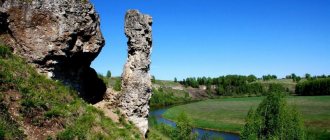
Stone Elk
- Coordinates: 59.962398, 42.941910.
Our ancestors thought that the moose was the largest animal in the world. Therefore, a huge boulder in the Sukhona riverbed, very similar to the head of an elk swimming across the river, was named after him.
The 8-meter-long and 4-meter-wide grayish-pink stone rises 2.5 meters above the water, but only at the end of spring, when the ice has completely melted, and in the summer. In autumn, during the season of heavy rains, it is hidden by water. Scientists believe that it had sacred meaning for our ancestors. Perhaps it was an altar on which elk were sacrificed.
The boulder also has another name - “The Tsar’s Table”, associated with Peter I. During one of his travels, the Russian emperor dined directly on it. The huge stone contained not only him, but also his entire retinue.
Stone woman
- Address: Kharovsk, st. Leningradskaya, 7.
A stone with a carved human face was discovered by accident in the Kharovsky district. Idols of this kind are quite common finds. It is believed that they are associated with the cult of ancestors and represent the head of the clan. Pagans usually asked such stones for harvests and childbirth.
The Kharovsky baba weighs about 3 quintals, and its height is almost 120 cm. The approximate age of the idol can be more than 2.5 thousand years. He has clearly distinguishable eyes, nose, mouth, a cross is carved on his chest, shoulder blades and the back of his head.
Similar artifacts have not been found here before, and the surrounding area does not look like pagan sanctuaries. Most likely, the idol was brought here along with sand during the construction of the road. Now it is on display at the Kharovsk Art Museum.
Iron-stone
- Address: Pustosh village, Totemsky district.
It is located near the village of Pustosh, on the left bank of the Edenga. He is not as famous as the Elk, although he is considered more serious in power and reverence. In ancient times there was a sanctuary of Perun here.
Despite its impressive dimensions (about 5 m wide, 2 m high and 8 m long), it is not at all easy to detect. There are huge steps on the east side of the stone. Once there were 12 of them, now there are only five left. And the depression on the southern side is called the trace of God, who sat down here to rest.
Not far from Utyug there is an ancient burial ground, which dates back to the 10th century. Presumably the burial belongs to Chudi, a mysterious Slavic tribe. However, there are no traces of their permanent presence in these places.
Today, the Boulder goes deeper into the ground, and on its surface people more often burn fires and barbecue than pray. But the local old-timers still remember how the old people cast spells on the stone: they covered it with towels and walked around it, whispering incantations and prayers.
Tiunovskoe sanctuary
- Coordinates: 60.413723, 43.694007.
An unusual archeological monument is located in the town of Tarnog, not far from the Korzha River. This is an altar slab and a large stone, which is most often called a “cross”. It looks like an irregularly shaped square, but closer to the top it begins to round. The entire surface of the stone is dotted with strange designs.
There are silhouettes of people, buildings, geometric figures, and letters of the Cyrillic and runic alphabets. Presumably, this is how the tribes who lived in these places in the 14th-16th centuries saw the model of their world. But, interestingly, they still cannot decipher the mysterious signs.
Amur region | Area 362 thousand square meters. km
The Amur region is in fifth place among the largest regions of Russia. It occupies an area of 362 thousand square meters. km, which in percentage terms is equal to 2.12% of the entire area of the Russian Federation. The date of formation of the subject is considered to be October 20, 1932. For a long time it was part of the Khabarovsk Territory, but in 1948 it was separated into an independent region. In total, 805 thousand 689 people live in the region, and the population density is 2.23 people/sq. km. Currently, one of the world's largest gas processing plants is being built here, which will include the largest helium production complex. In addition, this region is rich in minerals and has huge reserves of timber.
Geological natural monuments
Our planet is an amazing place. Day after day, century after century, different events took place: the earth's crust moved, volcanoes erupted, glaciers melted, only to form again after some time. We can see the results of such cataclysms now. And it is very beautiful, like everything created by nature.
Geological outcrop Myakolitsa
- Coordinates: 60.681344, 45.942800.
This natural monument is located on the left bank of the Sukhona. The shore in this place is high, up to 70 m, and steep. Time and wind have done their job, giving it bizarre shapes. But the most interesting thing is that sandy lenses are clearly visible among the Permian red flowers. These discontinuous layers of sand are about 250 million years old.
At the end of the 19th century, a paleontological study was carried out here for the first time and the fossilized remains of ancient reptiles, distant relatives of modern hippopotamuses, were found in the lenses. Some of those finds are now stored in the Vologda Museum-Reserve.
Cape Bull
- Coordinates: 60.660529, 45.718764.
The banks of the Sukhona are places of amazing beauty. Where the Verkhnyaya Erga flows into it, there is one of them - an erosional remnant named Bull. It is generally accepted that it looks like a bull drinking water, but still this name most likely comes from the field of architecture. After all, the “bull” in it is called a pyramidal protrusion that supports bridge supports.
The cape is made up of many layers of limestone and brightly colored marls, in which the fossilized remains of ostracods - lower crustaceans - are found. Limestone was once mined here, and even the old adit has been preserved. But the entrance to it is covered for security reasons.
In 1987, the outlier received the status of a geological natural monument. Now it is protected by the state in order to preserve the unique natural landscape, as well as endangered plant species.
Tract Colored flints
- Coordinates: 60.666983, 45.852027.
The landscape natural monument is located on the right bank of the Sukhona near the village of Krasavino. A geological outcrop 2 km long and 60-70 m high stands almost vertically above the river.
Between the layers of clay and marls there are colored flints interspersed with ornamental stones: amethyst, quartz, calcite. Actually, because of them the natural monument got its name.
The nature of the tract is also protected. Here, on the same territory, European and Siberian species of taiga plants coexist, many of which are listed in the Red Book of Russia and the Vologda region.
Olarevskaya ridge
- Coordinates: 59.383452, 40.078968.
The horseshoe-shaped moraine ridge on the border of the Sokolsky and Vologda regions is a landscape natural monument. Its length is more than 10 km. The Olarevskaya ridge appeared after the Valdai glaciation - the most recent in the northern part of Russia. Even now you can see huge boulders, up to 1.5 meters high, overgrown with lichen. This is all that remains of the glaciers.
The ridge is composed of loams, in which inclusions of igneous rocks, gneiss, and quartzite are found. There are also stones with a small admixture of iron ores. Sometimes they cause magnetic anomalies, causing travelers to wander in circles.
By the way, one of the interesting facts about this place is that most of the boulders are arranged in families: a large stone is Dad, next to it is Mom (slightly smaller) and around there are many small Children. Almost the entire ridge is covered with forest. There are aspen trees, spruce trees, birch trees, and even artificially planted cedar trees.
Irkutsk region | Area 774 thousand sq. km
The Irkutsk region ranks second among the largest regions of Russia. The total territory occupied by the subject is approximately 774 thousand square meters. km, which is almost 5% of the entire area of the state. In terms of territory, it is almost equal to Turkey, whose area is 780 thousand square meters. km. The founding date of the region is considered to be September 26, 1937, when the East Siberian region of the RSFSR was divided into Irkutsk and Chita. As of 2016, about 2.5 million people live here, which in terms of density is 3.11 people/sq. km. The Irkutsk region is one of the main suppliers of petroleum products, timber, coal and aluminum.
Holy and mineral springs
The Vologda land is very rich in miraculous springs. Each of them has its own legend or tradition. And rumors of healing properties spread far beyond the region.
Shelokhach sulfur springs
- Coordinates: 58.983371, 36.583570.
The group of hydrogen sulfide springs in the floodplain of the Chagodosha River received its name from the nearby settlement - the village of Shelokhach. Today they have been given the status of a hydrological natural monument.
The water in them is slightly mineralized, and, due to the high content of hydrogen sulfide, has medicinal properties. Most often people come to the springs with various skin diseases, radiculitis, rheumatism, etc.
Novsky source
- Coordinates: 59.191667, 39.529167.
Today there is a balneological resort on this site, but the healing spring was discovered completely by accident. In the middle of the 20th century in the village. New on the river bank The sick people began to conduct geological exploration.
For this purpose, a 270-meter well was laid, from which a water fountain unexpectedly began to flow. Chemical analysis showed that the composition and properties of the water are almost identical to the mineral springs of Solvychegodsk or Staraya Russa.
Sources of Dmitry Prilutsky
- Coordinates: 59.172383, 40.642267.
In the Mezhdurechensky district there is a unique natural monument - Dyakonovskaya Polyana. It is considered a place of power and is inextricably linked with the life of Dmitry Prilutsky, one of the most important saints of the Vologda region. A stone with his image and a worship cross were installed here, and a chapel was built. But the springs are considered the most revered in Dyakonovskaya Polyana.
There are three of them, located strictly according to the movement of the sun. The water in each has its own specific properties and is used differently.
The morning spring is called Afanasy. You need to drink its water for three days in a row; it is believed that only then will it remove all toxins from the body. Water from Nastasya, the daily spring, will relieve general ailments, and Paraskeva will help with skin diseases. It is recommended to collect water from sources only at certain times and drink strictly according to the plan.
Kirika-Ulitta tract
- Coordinates: 59.136693, 39.861674.
In the Vologda region, not far from the village of Kiriki-Ulitta, there is a tract with the same name. People often call it “Vologda Switzerland”. This hilly area covered with spruce forest, with a river flowing through it, really is somewhat reminiscent of alpine landscapes. Here is also one of the most revered holy springs in the region - Sokolovsky spring.
No one remembers how and where it was formed. The history of the spring goes back centuries. But old-timers say that even during a drought, when all the reservoirs dried up,
The Sokolovsky spring remained the only source of fresh water in the area. Today the area around it has been landscaped, a chapel has been built, consecrated in honor of St. Nicholas the Pleasant. And for 10 years now, on the feast of Epiphany, prayers have been served and the waters of the source are blessed.
Novosibirsk region | Area 177 thousand square meters. km
The Novosibirsk region ranks eighth among the largest regions of the Russian Federation. The area it occupies is 177 thousand square meters. km, which is 1.4% of the entire territory of Russia. The region is home to about 2.7 million people, and the population density is 15.54% people/sq. km. The bulk of the population is Russian (93%), about 7% are Germans, Ukrainians and Tatars. The subject was formed in 1937, when the West Siberian Territory was divided into the Altai Territory and the Novosibirsk Region. More than 500 deposits of various natural resources of the country are located here.
Anomalous places in the Vologda region
The supernatural has always excited the minds of people. Any oddity that could not be explained immediately became anomalous. The Vologda region is no exception. And here there are places that are of interest to paranormal researchers and ufologists.
Lake Ivachevskoye
- Coordinates: 59.163977, 38.077914.
A few kilometers from Cherepovets there is a reservoir that is considered a dead place. The anomaly is also evidenced by the twisted trees growing around it. Local residents say that people here begin to wander, losing their bearings, and often disappear.
Those who are lucky enough to return soon go crazy or commit suicide. People begin to have auditory hallucinations, believing that the lake is forcing them to submit and return.
Those who have lived in these places for a long time believe that the reservoir, like a higher mind, somehow influences the human psyche, forcing them to do strange things.
Judah aspen
- Address: Vytegorsky district.
As usual, aspen is called the Judas tree. It is believed that it was on it that the one who betrayed Christ hanged himself, although in fact this is not so. Now the name of the biblical money lover is associated with any oddities of a tree trembling in the wind. There is something like this in the Vytegorsky district of the Vologda region.
A twisted 12-meter aspen grows among the swamps. According to local residents, any clockwork stops next to it. One day, a group of ufologists decided to check whether this was actually true. Everyone's watches rose. An explanation for this anomaly has not yet been found.
Tyumen region | Area 1,464 thousand sq. km
Tyumen region is the largest region in Russia. The area of the subject is 1464 thousand square meters. km, which is equal to 9% of the entire territory of the Russian Federation. If we unite Germany, Italy, France and Great Britain, then the territory they occupy will be exactly equal to the Tyumen region. Its foundation took place in 1944 by separating some areas of the Kurgan and Omsk regions. The population as of 2016 is 3,615,485 people, density is 2.47 people/sq. km. Approximately 90% of the districts belong to the Far North. It is here that the main deposits of such minerals and natural resources as gas and oil are concentrated.
116 24
What places can you visit with children?
The Vologda region is exactly the region where it is recommended to come for a family holiday. What is a family without children? Even the little ones will find an adventure to their liking that they will remember for the rest of their lives.
Russian North Park
- Address: Siverskaya st., 9A, Kirillov.
A specially protected area located between the Arctic and Atlantic oceans was created to preserve not only the unique nature of the Vologda Lake District, but also its rich historical past.
The national park includes lakes and rivers, endangered flora and fauna, monuments of Russian northern architecture and archeology, and ancient historical villages. For tourists, park employees have developed special routes (on foot and on water) and eco-trails that allow them to cover as many attractions as possible.
Sugorye
- Address: Kirillovsky district, Goritsy village.
15 km from the Kirillo-Belozersky Monastery there is an unusual open-air museum. Once inside, you are completely immersed in the atmosphere of Ancient Rus' of the 11th-12th centuries. Several interactive programs have been prepared for guests, thanks to which they can
- introduce yourself as a warrior of the prince and take part in the military council;
- visit a forge and make a forged souvenir with your own hands;
- learn some secrets of blacksmithing.
The Viking House exposition will introduce visitors to the way of Scandinavian housing.
Holiday programs and master classes are often held on the territory of the museum complex. For example, here you can walk a special hunting trail with obstacles, shoot with a bow and crossbow, or practice throwing the ancient Russian sulitsa spear.
And then come to a gathering with an ancient samovar, heated on coals with traditional northern treats and Russian drinking songs.
Sverdlovsk region | Area 194 thousand sq. km
The Sverdlovsk region is one of the largest in Russia. Its lands are located on 194 thousand square meters. km, as a percentage of the country's area this is 1.14%. The subject is part of the Ural Federal District. Its foundation took place in 1732. The administrative center is the city of Yekaterinburg, which was previously called Sverdlovsk. More than 4 million people live here, which is 22.28 people/sq. km. This is one of the most densely populated regions of the state. On its territory there are deposits of gold, platinum, asbestos, bauxite, nickel, iron, manganese, chromium and copper. The largest chemical plant in the Russian Federation, Uralkhimplast, is located here.
Administrative division
Urban districts of Vologda and Cherepovets, Districts: No. Name of the district, administrative center. 1 Babaevsky district, the city of Babaevo 2 Babushkinsky district, the village named after Babushkin 3 Belozersky district, the city of Belozersk 4 Vashkinsky district, the village of Lipin Bor 5 Veliky Ustyug district, the city of Veliky Ustyug 6 Verkhovazhsky district, the village of Verkhovazhye 7 Vozhegodsky district, the town of Vozhega 8 Vologda district, the city of Vologda 9 Vytegorsky district, the city of Vytegra 10 Gryazovetsky district Gryazovets town 11 Kaduysky district Kaduy township 12 Kirillovsky district Kirillov city 13 Kichmengsko-Gorodetsky district Kichmengsky Gorodok village 14 Mezhdurechensky district Shuiskoye village 15 Nikolsky district Nikolsk city 16 Nyuksensky district Nyuksenitsa village 17 Sokolsky district Sokol city 18 Syamzhensky district Syamzha village 19 Tarno gsky district village Tarnogsky Gorodok 20 Totemsky district, Totma city 21 Ust-Kubinsky district, Ustye village 22 Ustyuzhensky district, Ustyuzhna city 23 Kharovsky district, Kharovsk city 24 Chagodoshchensky district, Chagoda town 25 Cherepovets district, Cherepovets city 26 Sheksninsky district, Sheksna town