The most beautiful places in the Tver region: TOP-3
The most popular natural sites of the region are known far beyond its borders. Their names are often mentioned in the media, historical films and books.
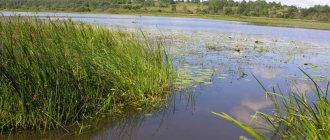
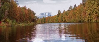
Lake Seliger
- Coordinates on the map: 57.239082, 33.034332.
One of the largest bodies of water in Russia has become famous due to its participation in important historical events and the annual youth festival that takes place on its banks. One half of the lake is part of the Tver region, the other belongs to the Novgorod region.
There are about 160 islands of different sizes protruding from Seliger, the largest of which is Khachin. The lake is fed by hundreds of rivers and streams, but only one flows out - the Selizharovka River.
The shores of this attraction are covered with dense forests. In the south of the reservoir, the city of Ostashkov grew up, and the ancient estate of New Yelets has been preserved nearby. The lake is sometimes called Ostashkovsky, but in other regions it is still better known as Seliger.
Uglich Reservoir
- GPS coordinates: 57.115324, 37.713252.
The reservoir for the Uglich hydroelectric power station was built back in 1939 and became an integral part of the local landscape. A small part of the reservoir is located in the Uglich district of the Yaroslavl region, but the majority belongs to the neighboring region. Controlled by man, the elements swallowed up dozens of settlements and churches in three districts of the Tver region.
Particularly popular among tourists is the section of the reservoir, which is located in the Kalyazinsky district. The reservoir became widely known thanks to the submerged bell tower protruding from the water near the city of Kalyazin. Tourist ships regularly visit the structure. The reservoir also attracts fishing enthusiasts: its waters are home to pike, ruffe, bream, burbot and other types of fish.
Source of the Volga
- Coordinates: 57.251276, 32.467764.
In the Ostashkovsky district, the largest river in Central Russia, the Volga, originates from springs. It is difficult to imagine that these trickles of muddy water after a few kilometers will turn into a wide, full-flowing river, along which multi-ton ships can easily glide.
During the Soviet years, a dam was built at the source of the Volga, but years later it was destroyed. Around the spring there are still huge stone boulders - the remains of the structure.
Several years ago, the source was improved: a wooden bridge was stretched over it, a large arch with a dome and a cross was placed in front of it, and a small chapel in the same style was erected above the spring itself. Souvenir sellers and artists can often be seen near the bridge.
Interesting Facts
As of 2022, the population density of the Tver region is 2,600 people per 1 sq. km. The city has many areas with one-story buildings, especially in the historical part. During the Soviet period, Tver was actively developing, many factories and large industrial facilities appeared, for example, a thermal power plant, a worsted plant, a pharmaceutical factory and a fiberglass production plant.
After the collapse of the USSR, the population of the Tver region found itself in a difficult situation. The region traditionally specialized in light industry and food products, and after the annexation of the “fraternal” republics, trade turnover fell sharply. Between 1990 and 2000, virtually no construction or improvement work was carried out in the city.
A new life for Tver begins in the mid-2000s, when four high-rise microdistricts appeared on the map. In addition, with the initiative of the mayor, Tver is beginning to hold the largest economic forum in Russia, which gives the region additional dividends.
The main nature reserves of the Tver region
The ancient lands of the Tver region store priceless gifts of nature. So that future generations could see the wonderful nature of the region with their own eyes, large nature reserves were created.
Central Forest Reserve
- Coordinates: 56.457173, 32.974151.
An extensive nature reserve was founded in 1930 in the vicinity of the city of Nelidovo. 52 years later it was given biosphere status. The protected area of approximately 70,000 hectares is covered by relict forests, numerous rivers and swamps. The reserve includes the ancient Okovsky forest.
The flora includes more than 540 species and is unique in its own way, because this is the only place in all of Europe where you can see southern taiga spruce forests untouched by humans. In addition to spruce trees, the forests contain linden, oak, birch, pine, ash and other trees. A significant part of the protected area is occupied by sphagnum swamps, among which the Katin Moss swamp stands out especially.
The CLZ is home to 56 species of mammals, 11 species of reptiles and amphibians, and many insects. Some species are very rare; birds need special protection: out of 200 species of birds, 16 are listed in the Red Book of Russia, and 2 - the black stork and the white-tailed eagle - are even under international protection.
Zavidovo National Park
- Coordinates: 56.418889, 36.129722.
It was founded in 1972 on the border with the Moscow region. According to UNESCO experts, a huge park with an area of 125,000 hectares is the cleanest area on the planet. The protected area covers 86 settlements with a total population of more than 20,000 people. The largest is the village of Zavidovo, which gave the name to the park.
The reserve's lands are covered by meadows, as well as coniferous, deciduous and mixed forests. A significant area is occupied by reservoirs, and part of the non-surface area is swampy.
One of the residences of the President of the Russian Federation is located on the territory of the national park. The rules in Zavidovo are not as strict as in many other Russian nature reserves; construction, industrial and agricultural activities can be carried out in unprotected areas, but cutting down trees is prohibited in the forests.
Reserve "Staroselsky Moss"
- Coordinates: 56.475833, 33.036111.
The picturesque swamp with an interesting name has the status of a nature reserve of regional importance. The area of “Staroselsky Moss” is more than 600 hectares, the average depth is about 3 meters. Spruce and pine trees grow along the banks of the swamp, and birch trees are occasionally found. In total, there are several dozen valuable plants on the territory of the reserve. Tourists should not visit the swampy area alone, so as not to accidentally fall into its traps.
Konakovsky Bor
- Coordinates: 56.701003, 36.753133.
A wonderful pine forest near the city of Konakovo is a wonderful place for outdoor recreation. Coniferous aroma, evergreen plants, distance from city noise - this is not all that this wonderful forest park can offer its guests.
On its territory there are wooden sculptures of fairy-tale characters that young children love: Kolobok and the Fox, Bunny, Leshy, Mikhailo Potapych, Baba Yaga and many others. After a long walk, you can quench your thirst at the local spring and relax on the comfortable wooden benches.
Facts about the residents of the region
The population of the Tver region: the number of Russians is 92%, of other peoples the largest number are Ukrainians - 1.5%, Armenians - 0.5% and the small peoples of Tver Karelians, just over 14 thousand people live in the region. In addition, Chuvash, Germans, Chechens, Moldovans, Georgians and Uzbeks were registered here.
In the region there are 23 cities of varying density, mostly with a population of no more than 30-40 thousand people, with the exception of the city of Rzhev with 59 thousand population.
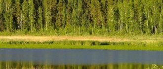
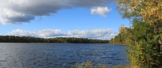
Interesting lakes and waterfalls in the Tver region
The Tver region is a lake region; there are more than 1,700 reservoirs on its territory. Some lakes are especially popular among tourists, fishermen and athletes.
Lake Brosno
- Coordinates: 56.836825, 31.940022.
A small but deep lake is located in the Andreapolsky district. The average depth of the reservoir is about 17 meters, the lowest point is at 42 meters. Popularly called the “Russian Loch Ness,” ancient legends say that a huge monster, similar to the Scottish monster, lurks in its dark waters. Few saw the creature, but many men and women claimed to have heard the dragon's roar and felt the unbearable stench emanating from its mouth.
Modern experts have found a scientific explanation for this myth. Rotting processes are continuously taking place at the bottom, the resulting hydrogen sulfide rushes upward, bubbles of poisonous air come to the surface and, bursting, spread a stench around. The seething water and unpleasant smell frightened local residents and gave rise to stories about a terrible dragon living in the lake. Nevertheless, even today, some tourists come to Brosno in the hope of seeing some fantastic creature on its shores.
Lake Bologoe
- Coordinates: 57.863357, 34.077465.
One of the largest reservoirs in the Tver region is located at the border of the region, near the city of the same name. The lake is relatively shallow, with an average depth of only 3 meters. In the middle of this attraction there is an island on which a hydrogen sulfide spring gushes out like a fountain.
Bologoe is conventionally divided into two parts: the one closer to the city is polluted with waste, the further part is clean and suitable for recreation. At the end of the 19th century, archaeologists excavated a site of primitive man on one of the banks. Later, scientists discovered the skull of an ancient dog that lived in these parts almost 10,000 years ago.
Lake Velikoye
- Coordinates: 57.890755, 33.873286.
A large relict reservoir in the Rameshkovsky district is all that remains of a huge periglacial lake. Velikoye is part of the Orsha-Petrovsky lakes system, consisting of more than 140 reservoirs, and is significantly larger in size than all its counterparts.
The even oval of the lake stretches from north to south; getting to the water is very difficult, since the banks are swampy and densely overgrown with reeds. Nevertheless, all these difficulties do not stop avid fishermen who come to Velikoye every year for a rich catch of fish. Connoisseurs of local swamps also visit the lake to pick cranberries and other edible berries.
Konstantinovsky quarry
- Coordinates: 56.846622, 36.006103.
Located near Tver. In Soviet times, sand was mined in the quarry, but in the 80s, work stopped and the quarry was flooded. Now there is a pond splashing on this place, and the sandy beaches attract local residents and tourists in the summer.
The entry into the water is gentle, so the quarry is suitable for families with children. Vacationers not only swim and sunbathe, but also dive from small islands in the middle of the reservoir, fish, spend the night in tents, go diving and sailing.
Waterfall in the village of Panika
- Coordinates: 57.000978, 35.081362.
The endangered village of Panika in the Torzhok region has practically lost its inhabitants in recent years, but receives hundreds of tourists every year. Near the settlement there are rocks with a small opening in them. In the late 80s, quarrying was going on near the village. One fine day, workers accidentally drilled a well to an underground river, and a stream of water gushed out.
Later it turned out that inside there were karst cavities in which the lake was hidden. The river began to flow through the resulting passage and fall from a height of several meters, running down three stone steps.
The picturesque waterfall attracted tourists and became a local attraction. The area around the waterfall was landscaped, steps were laid to the grotto, and a neat stone bridge appeared at the foot of the rocks. In the hot summer the waterfall dries up, but in the spring it is filled with fresh moisture again.
Districts
There are 36 districts in the Tver region, the largest are Torzhoksky, Ostashevsky, Nelidovsky, Likhoslavalsky, Kashinsky, Kalyazinsky, Vyshnevolotskaya with a population of over 20 thousand people. Over 30 thousand people already live in the Bezhetsky, Bologovsky, Kalininsky districts, and 419 thousand live in Tver itself. In addition, over 250 rural settlements of varying population densities are recorded in the region.
In the Tver region there are two closed administrative points: Ozerny, where the Guards Missile Division is located, as well as ZATO Solnechny - an urban-type settlement located on one of the islands of Lake Seliger; back in Soviet times, a plant for the production and study of chemical weapons was opened here.
Mineral and holy springs of the area
The Tver region is rich in springs; each district boasts the presence of a dozen clean springs. Many of them are associated with stories of healing from serious illnesses and other miracles.
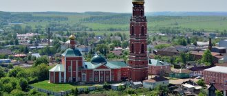
Kashinsky mineral springs
- Coordinates: 57.363200, 37.601390.
The mineral waters of the city of Kashin are known throughout the country. The Three Springs have long been a place of pilgrimage for believers. Orthodox Christians came to the city to venerate Saint Anna of Kashin, and at the same time collected water from holy springs.
At the beginning of the 19th century, local doctor D. Chernyavsky investigated the healing properties of mineral water and contributed to the creation of the Kashin balneological resort. The springs were soon abandoned, but in 1883 the area found a second life and became a popular resort.
At the beginning of the 19th century, next to the well-equipped sanatorium, a mud bath was erected, in which peat mud treatment was carried out. Some experts noted that Kashinskaya mineral water is richer than Zheleznovodskaya.
During the Soviet years, springs were also used to treat and prevent many diseases. In addition to already known sources, several new wells have appeared. Nowadays, mineral water is used not only in the local sanatorium, but is also bottled and sold in almost all regions of the country.
Mshenskie springs
- Address: s. Mshentsy, Bologovsky district.
Nature has given the ancient village of Mshentsy many cold and clean springs, among which the two largest stand out: the Vmch spring. Paraskeva Fridays and the source of the Kazan Icon of the Mother of God. The first was named after the temple of the same name, the only building that survived from the destroyed monastery. In the second, according to legend, in 1812 the miraculous image of the Blessed Virgin Mary appeared.
At the beginning of 1916, the archaeologist and writer N. Roerich described the springs in his essay “The Undrinking Cup.” Years later, local historian L. Bricker immortalized an excerpt from the work on a tablet, which he later hung on a large stone boulder near the springs. Today the springs are recognized as a natural monument; a wooden chapel rises above one of them.
Red key
- Address: village Kholokholnya.
An unusual source is hidden among the forests in the vicinity of the village of Kholokholnya. The waters of the spring are known for their high iron content, due to which the ground through which the spring flows turns red-brown, as if covered with rust. A stormy stream runs briskly along a steep slope, forms a picturesque waterfall and flows into the Kholokholnya River.
Yeletsky spring
- Address: pos. Elets.
The spring near the city of Yeltsy was named “Zdorovets” and was consecrated in honor of St. Paraskeva Fridays. The first mention of the holy spring dates back to the end of the 15th century. Currently, a high chapel has been erected above the spring, inside of which there is a font for immersion. Outside you can get water from a special tap. The holy spring belongs to the territory of the Zhitenny Monastery.
Maslovskie springs
- Address: village Maslovo.
The springs near the village of Maslovo are popularly called “the springs of living and dead water.” One of the springs was consecrated in honor of St. John the Baptist, with fonts and a small church built above it. The second spring is nicknamed “eye”, as its waters can heal eye diseases.
The water temperature in the two springs does not rise above 4°C all year round. The springs are saturated with minerals and truly have healing properties; many pilgrims claim that they can see better simply by washing their faces with cold water.
Okovetsky key
- Coordinates: village Okovtsy.
A clean, cold spring gushes out of the ground near the village of Okovtsy like a stormy stream and runs down the drain into the nearest river. In Okovtsy, the legend about the origin of the holy spring is passed down from generation to generation.
In 1539, two thieves were hiding in the Okovets forest and suddenly saw an icon of the Holy Cross above a spring. A monk of the Selizharov Monastery named John came to the place of the miraculous phenomenon. Arriving in the village, the monk discovered an icon of the Mother of God with the Child Christ.
Pilgrims flocked to the icons and the spring, many believers were healed of illnesses. Metropolitan Joasaph ordered the construction of two churches nearby: in honor of the Hodegetria icon of the Mother of God and in honor of the Origin of the Honest Trees. During the Soviet years, the icons disappeared without a trace, and the source was desecrated.
After the collapse of the USSR, a new church was erected on the site of the destroyed churches and comfortable wooden baths were installed for immersion in holy water. Every year at the end of July, after the festive liturgy, believers go in procession from the temple to the source.
Age and gender composition
As throughout the world, the prosperity of a region is determined by the ratio of young and old people. If a lot of young people live in an area and children are born, it means that it is promising and is developing correctly; it is not profitable for the new generation to leave here.
According to the latest census in the Tver region, there are more women than men by 10-12%. But the same indicators are observed throughout Russia. And the number of working-age population is not much greater than the number of people of retirement age.
The beautiful islands of Seliger
Lake Seliger is rich in islands. Many of them played an important role in the life of the entire country and are of great importance not only from a natural, but also from a historical point of view.
Khachin Island
- Coordinates: 57.268942, 33.036542.
Spacious Khachin is the largest island of Seliger. Despite its size, its four villages are home to fewer than 20 people. The main inhabitants of Khachin are wild animals: bears, foxes, hares, wild boars, moose, badgers, muskrat. Waterfowl nest along the banks, among which the rare bittern stands out.
The island is so large that it contains 13 lakes rich in fish. Small reservoirs contain pike, perch, burbot and roach. In some, eel and tench are found, and beavers settle on the banks. There are two summer boarding houses on Khachin.
Gorodomlya Island
- Coordinates: 57.202670, 33.065800.
The second largest island of the great Tver Lake has witnessed many historical events. The first settlements appeared here several thousand years ago. In the 16th century, the island belonged to the boyar Belsky, who then granted it to the boyar Lykov. After 20 years, Lykov transferred the land of the Nilo-Stolobenskaya desert. The monks founded the Gethsemane monastery on Gorodomlya.
In the 1930s, a scientific institute for the study of foot-and-mouth disease appeared on the island. Virologists under the leadership of A.L. Skomorokhov were looking for a vaccine against a terrible disease. During the Great Patriotic War, a military hospital was located here. After the war, a machine-building plant was built, and the island itself became a sensitive facility.
Currently, Gorodomlya remains a closed island, but getting to it has become much easier. The island is covered with relict coniferous forest; among the trees, ancient monastery houses and a tall wooden church have been preserved. On Gorodomlya you can see a kind of smaller copy of Seliger: in the middle of the island there is a small lake, which in turn contains several small islands.
Klichen Island
- Coordinates: 57.180168, 33.087952.
The island with an area of about 90 hectares on Lake Seliger has the status of a natural monument. Klichen is so big that it contains a lake. From a bird's eye view, the island looks like an uneven donut. The island is covered with pine trees; among the evergreen trees there are willows, alders, junipers, birches and maples.
Centuries ago, the city of the same name, which belonged to the Principality of Suzdal, rose on the island. The Klichen fortress stood in the way of merchant ships. According to one version, the name of the town comes from the word “cry”.
When enemies attacked the island, the watchmen sent out a cry throughout the village so that the local residents would hide behind the high walls, and the warriors would rise to defend the fortress. In the 14th century, Novgorodians razed the proud and independent city to the ground.
Today no one lives on the island, but in good weather it can be quite crowded. Residents of nearby Ostashkov and tourists from other cities and regions come to Klichen to relax in silence, enjoy the wonderful pine aroma and pick berries. Raspberries, lingonberries, blueberries and strawberries grow in abundance in the pine forest.
Stolobny Island
- Coordinates: 57.234679, 33.061775.
The green island of land in the north of Seliger became famous thanks to the Orthodox monastery, which was built on it in the 16th century according to the behest of St. Neil of Stolobensky. The monastery occupies the entire territory of the small island; part of the monastery buildings is located on the neighboring Svetlitsa peninsula. A strong bridge stretches from Stolobnoye to the “mainland”, so you can get to the Nilo-Stolobenskaya hermitage by car.
The Nilo-Stolobenskaya hermitage flourished until the October Revolution, when the Bolsheviks who came to power closed the monastery and turned it into a colony for juvenile delinquents.
Later, a prisoner of war camp, a military hospital, a nursing home, a camp site and other secular organizations were located on the island. In the early 90s, the deserts were transferred to the Russian Orthodox Church and restored. Today, pilgrims from all over the country come to Stolobny to join the Orthodox shrines and enjoy the natural beauties of Seliger.
Places of work of the population
The population of the Tver region is mainly employed in the manufacturing industry: the production of furniture, building materials, textiles and leather goods. In addition, the region has developed the production of equipment for Russian Railways: passenger cars, electric trains, excavators, etc. The production and distribution of electrical energy reserves brings large income to the regional treasury. The Kalinin NPP and Konakovskaya GRES provide electricity to several neighboring regions.
The local lands are rich in peat deposits, which is why the largest peat mining company in Russia operates here. Even 20 years ago, coal was actively mined here, but the surface deposits have dried up, and developing new ones is unprofitable and expensive.
In the field of transport, the Tver region is in a very advantageous position. There are two highways, 4 railway lines, and two civil airports operating near Tver with daily domestic and international flights.
Agricultural output has fallen by half since 1990, but is still gradually returning to strength. The fields are sown with flax, wheat and vegetables.
Unusual trees
Ancient forests have been preserved in many areas of the Tver region. Some unique relict trees have received special status and have become popular tourist attractions.
umbrella pine
- Address: village Ivanishchi.
In the village of Ivanishchi there grows a rare and valuable tree from a botanical point of view. The girthless six-meter trunk of the pine tree holds an evergreen canopy of the crown, which, like a huge umbrella, protects visitors from rain and snow. The age of the amazing tree is 300 years.
Kashinskaya pine
- Address: village Sudnikovo.
Another unique pine tree adorns the outskirts of the village of Sudnikovo. Local residents estimate that the tall tree is 800 years old. The pine tree consists of four trunks-branches that are intertwined at the base. Unfortunately, two large branches were “cut down” by lightning; dry stumps stick out from the trunk like snake heads. In 2022, Sudnikovskaya pine represented the Tver region at the all-Russian competition “Russian Tree of the Year”.
Alexander Nevsky Oak
- Address: city. Toropets.
In the ancient city of Toropets there is a tree, unremarkable at first glance, surrounded by a fence. A sign on a pole nearby explains such close attention to the plant: according to legend, the tall oak is a direct descendant of the oak that Prince Alexander Nevsky planted in 1239 in honor of his wedding. Local residents are proud of the landmark and carefully protect it.
National composition
The population of the Tver region is 1.29 million people with an average density of 15 people. per 1 sq. km, which is the lowest figure in the Central Federal District. Most people live in cities, more than 70%, and only 30% in rural areas. This trend is connected with the general trend towards the extinction of the village in Russia. According to the latest census of the Tver region, the population is now at its lowest level since 1926. The reason is the high percentage of people leaving for the capital or neighboring, richer regions, especially from the countryside, where there is neither work nor decent social conditions.
Where else to go in the Tver region
In addition to reservoirs, springs and islands, dozens of other rarer natural monuments can be found in the Tver region.
Staritsa caves
- Coordinates: 56.448755, 34.916780.
Hidden in the rocks on the banks of the Volga is a wonderful natural attraction with a rich past - dark caves with a total length of 30 kilometers. Some of the underground passages are of natural origin, the rest were created by human hands back in the 13th century. The quarries produced building material for the most important structures: fortress walls, temples, princely chambers.
Artels of stonemasons worked for about 7 centuries and ceased to exist only in the 1920s during collectivization. The underground tunnels are so long and intricate that speleologists have not yet been able to fully explore them; narrow corridors with magnificent stalactites and stalagmites are fraught with many surprises. Some paths were filled up during the Soviet period.
According to some reports, during the Great Patriotic War, some quarries were used as weapons warehouses. Research of the caves has been carried out since 1993; over the past decades, more than one expedition has gone to the catacombs, but the treasured treasures have never been found. Currently, scientists continue to study the Staritsky caves, and excursions are held for brave tourists.
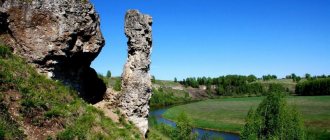
Rocks on the river holding
- Coordinates: 56.216547, 34.790228.
The main natural attraction of the Zubtsovsky district is atypical for the Tver region: on the banks of the Derzha River there are white cliffs up to 30 meters high. The limestone ledges are overgrown with trees and shrubs; the dark greenery of the vegetation emphasizes the whiteness of the rocks and makes them even more picturesque.
From the top of the hill there is a dizzying view of the river and surrounding forests. Extreme sports enthusiasts love to raft along the Dyorzha River and admire the rocks. Tourists who prefer a relaxing holiday simply enjoy the magnificent scenery, take photographs or fish at the foot of the cliffs.
Orchid slide
- Address: village Ilyinskoe.
A small plot of land in the Vyshnevolotsky district is one of the most beautiful and fragrant places in the region. Delightful orchids bloom every year on an area of 1 hectare. In addition to the delicate flower, dozens of other valuable plants grow on the hill, including rare flowers and herbs. In 1986, Orchid Hill was given the status of a natural monument, and since then any activity harmful to the environment has been prohibited in the protected area.
Filimonovsky Fountain
- Address: village Filimonovo.
A unique hydrogen sulfide spring gushes like a fountain on the banks of the Berezayka River directly opposite the village of Filimonovo. A stream of clear water rises 40 centimeters above ground level, sparkling cheerfully in the sun. Finding a natural monument is not easy, since the fountain “plays” in the middle of a small lake. Tourists not only drink water rich in iron and hydrogen sulfide, but also swim in it.
Belsky stone altar
- Coordinates: 55.836192, 32.931430.
In the Tver region there are interesting stone boulders recognized as tourist attractions. Gray giants stand out from many other stones due to their unusual shape, strange marks and imprints, and most often due to their connection to the pagan past of the region.
Thus, in the Belsky district, at the foot of the Cathedral Mountain, a rectangular boulder was found that looks like an ancient altar. It is believed that in this place ancient tribes performed special rituals and, possibly, sacrifices. Not far from the boulder there was a similar stone, but it disappeared in an unknown way several decades ago.
Do not miss the sights of the cities of the Tver region - Torzhok, Bezhetsk, Vyshny Volochek, Likhoslavl, Rzhev and Kimry
You may also be interested in interesting places in the neighboring Yaroslavl, Novgorod, Vologda and Pskov regions
The Tver region is a place where historical sights are perfectly combined with luxurious nature. In this wonderful region you can break away from the hustle and bustle of everyday life, forget about daily stress and truly relax your soul and body.
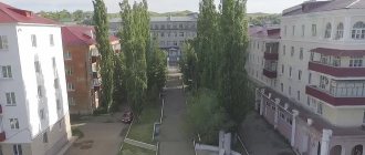
Population
The main city of the region has a rich and glorious history. The city is located in a picturesque location, located on both sides of the Volga River. Today, the population of Tver exceeds 400 thousand. The city stands on the Upper Volga Plain, with only low hills and elevations.
The Volga has always been of great importance in the history of Tver. Merchants rafted along the river, transporting timber and other goods directly to Moscow. The widest point of the river within the city is 552 meters. The first mention of a rural settlement in these parts dates back to the 11th century. In the 13th century, the first city was completely destroyed by the Tatars, but was quickly rebuilt. There is a version that after the devastation on the left bank, the population of Tver moved to the right side of the Volga and built a new settlement here.
At the end of the 15th century, Tver became an important trade and cultural center. Here are the routes of communication between Novgorod and Vladimir. In addition, it was in Tver that unique monuments of ancient Russian literature were created: “The Tale of Mikhail Alexandrovich”, “A Word of Praise to the Tver Prince Boris Alexandrovich”. The city has preserved many churches, the Kremlin with examples of traditional Russian architecture.
Today, 419 thousand people live in Tver, a fairly high figure; over the past decades, there has been no sharp departure of residents to other regions. The highest numbers were recorded in the late 90s, when over 450 thousand people lived in the city.
Crime
The cities of the Tver region have been in crime news more than once. Back in the early 90s, as throughout the country, bandits or “new Russians” operated here. Among all, the Tver Wolves gang stood out, committing murders in the region for several years. The leader of the gang, Alexander Kostenko, or Lom, already in the late 90s took over almost the entire shadow business of Tver. The group, in addition to fighters and killers, included corrupt officials, well-versed lawyers and some security officials.
The manner in which the Tver Wolves conducted business kept the entire population of the cities of the Tver region in fear. From obedient and faithful people, Lom put together a brigade of terrorist killers, they did not spare anyone and acted on the principle “the more victims, the better.”
They killed their enemies en masse, for everyone to see, to demonstrate their power and avoid any disobedience. One of their bloodiest crimes was the massacre of the market director’s family; the killers spared no one, not the director’s wife, nor his two minor children. It is this gang that is suspected of murdering the famous singer Mikhail Krug.
One of the latest high-profile cases is the murder of 9 people in the Tver region. The tragedy occurred in June 2022, when in a friendly cooperative Sergei Egorov without regret dealt with 9 people, sparing no one, not even an old disabled woman. This story thundered throughout the country; Yegorov himself practically did not give interviews, once telling reporters that he killed people because they laughed at him. In the fall, Egorov was sentenced to life imprisonment.
Cities[ | ]
| № | Name | district / district[30] | municipal district/city/mun. district[31] | population (persons) | founding/first mention | city status | coat of arms | former names |
| 1 | Andreapol | Andreapol municipal district | Andreapol municipal district | ↘6703[7] | 1907 | 1967 | Andreyapol | |
| 2 | Bezhetsk | Bezhetsky mun. area | Bezhetsk municipal district | ↘20 097[8] | 1137 | 1775 | Gorodetsk (until 1766) | |
| 3 | White | Belsky municipal district | Belsky municipal district | ↘3057[9] | 1350 | 1350 | ||
| 4 | Bologoe | Bologovsky municipal district | Bologovsky municipal district | ↘20 178[10] | 1495 | 1918 | ||
| 5 | Vesyegonsk | Vesyegonsky municipal district | Vesyegonsky municipal district | ↘5846[11] | 1564 | 1776 | ||
| 6 | Vyshny Volochyok | Vyshnevolotsk city district | Vyshnevolotsk city district | ↘44 722[12] | 1471 | 1770 | ||
| 7 | Western Dvina | Zapadnodvinsk municipal district | Zapadnodvinsk municipal district | ↘7608[13] | 1900 | 1937 | ||
| 8 | Zubtsov | Zubtsovsky municipal district | Zubtsovsky municipal district | ↘6084[14] | 1216 | 1216 | ||
| 9 | Kalyazin | Kalyazinsky municipal district | Kalyazinsky municipal district | ↘12 294[15] | 1434 | 1775 | ||
| 10 | Kashin | Kashinsky city district | Kashinsky city district | ↘13 576[16] | 1238 | 1238 | ||
| 11 | Kimry | city district city of Kimry | city district city of Kimry, | ↘42 301[17] | 1546 | 1917 | ||
| 12 | Konakovo | Konakovsky municipal district | Konakovsky municipal district | ↘35 407[18] | 1806 | 1937 | Kuznetsovo (until 1929) | |
| 13 | Red Hill | Krasnokholmsky municipal district | Krasnokholmsky municipal district | ↘4950[19] | 1518 | 1776 | ||
| 14 | Kuvshinovo | Kuvshinovsky municipal district | Kuvshinovsky municipal district | ↘8853[20] | 1624 | 1938 | ||
| 15 | Likhoslavl | Likhoslavl municipal district | Likhoslavl municipal district | ↘11 285[21] | 1624 | 1925 | ||
| 16 | Nelidovo | Nelidovo city district | Nelidovo city district | ↘17 639[22] | 1900 | 1924 | ||
| 17 | Ostashkov | Ostashkovsky city district | Ostashkovsky city district | ↘15 187[23] | 1371 | 1770 | Klichen | |
| 18 | Rzhev | city district city of Rzhev | city district city of Rzhev, | ↘56 399[24] | 1216 | 1216 | Rzhev Volodimirova , Rzhevka , Rzhov . | |
| 19 | oxbow | Staritsky municipal district | Staritsky municipal district | ↘7222[25] | 1297 | 1297 | Gorodok , Gorodesk | |
| 20 | Tver | city district city of Tver | city district city of Tver, | ↘424 969[26] | 1135 | 1135 | Kalinin (1932—1990) | |
| 21 | Torzhok | city district city of Torzhok | city city of Torzhok, | ↘43 614[27] | 1139 | 1139 | New Bargain | |
| 22 | Toropets | Toropetsk municipal district | Toropetsk municipal district | ↘11 527[28] | 1074 | 1074 | ||
| 23 | Udomlya | Udomelsky city district | Udomelsky city district | ↘26 726[29] | 1478 | 1981 |
Settlements that have lost their city status[ | ]
Preserved, but lost city status:
- Vertyazin is now the village of Gorodnya. The city in the XIV-XVI centuries.
Destroyed:
- Korcheva - flooded by the Ivankovsky reservoir in 1937. City since 1781.
Pastime of the population
There are many monuments of historical and cultural heritage in Tver and the region. There are especially many preserved monasteries and temples, some of which are more than 500 years old. The Ascension Cathedral in Tver was built in the mid-18th century and today has the status of a bishop's courtyard. The church burned more than once and was rebuilt; today the relics of the holy martyr Thaddeus are kept here.
A real work of art is the Staritsky Holy Dormition Monastery, which is located in a picturesque location on the banks of the Volga. The monastery was founded in the 12th century, but the first buildings have not survived to this day and were destroyed in the 14th century. Almost a hundred years later, the monastery was rebuilt from scratch; it is these white stone buildings that have survived today.
The unique temple is located in the city of Torzhok; the wooden building, built in the 18th century, has stood with minimal restoration for more than 200 years. Even a painting from the mid-18th century has been preserved in almost intact condition.
Education and science
There are 17 universities in Tver (including branches of Moscow universities), 11 secondary specialized educational institutions and the Suvorov Military School.
The total number of students annually receiving education in educational institutions in Tver exceeds 50 thousand people.
//
Higher educational institutions in Tver:
Tver State University (TvSU)
Founded in 1970. The university traces its history back to 1870, when the private pedagogical school of P.P. Maksimovich was opened in Tver, transformed in 1917 into the Tver Teachers' Institute, and then into the Kalinin Pedagogical Institute. In 1970 the institute was reorganized into Kalinin State University. In 1991 it was renamed Tver State University. The university has 16 faculties: biology, history, mathematics, pedagogy, geography and geoecology, foreign languages and international communications, advanced training for educators, applied mathematics and cybernetics, psychology and social work, management and sociology, physical education, physics and technology, chemical, economic, legal.
The structure of the university includes an Internet center, a botanical garden, a Center for International Relations, a museum, graduate school, doctoral studies, a patent department, a technology park, an open education center, and a Regional Informatization Center. There are scientific research laboratories. The scientific library has 1.2 million items, incl. about 150 thousand rare publications of the 19th-20th centuries.
Tver State Technical University (TSTU)
TSTU has seven faculties and an institute of further education. They train 6,000 students in all forms of education in more than 40 specialties and areas.
Tver State Medical Academy (TSMA)
Faculty of Medicine, Faculty of Dentistry, Faculty of Pediatrics, Faculty of Pharmacy, Higher Nursing Education, Dental Hygienist.
Tver State Agricultural Academy (TSA)
The Tver State Agricultural Academy (TSAHA) traces its history back to 1972, when the agricultural institute was organized. In 1995, it was transformed into an academy, which included four faculties: agronomy, biotechnology, engineering and economics.
Branch of the State Academy of Slavic Culture in Tver (GASK) Verkhnevolzhye Institute (IV) Tver branch of the Moscow State University of Economics, Statistics and Informatics (MESI) (MGUESI) Tver branch of the Moscow Humanitarian-Economic Institute (MGEI) Tver branch of the Moscow University of the Ministry of Internal Affairs Russian Federation (MU Ministry of Internal Affairs of the Russian Federation) Branch of the Russian State Humanitarian University (RGGU) Branch of the Russian Correspondence Institute of Textile and Light Industry (RZITILP) Tver branch of the Modern Humanitarian Academy (SHA) Branch of the St. Petersburg State Engineering and Economic University in Tver (SGIEU) Tver branch of the St. Petersburg State University of Technology and Design (SGUTID) Branch of the North-Western Academy of Public Administration in Tver (SZAGS) Tver Institute of Economics and Management (TIEIM) Tver Institute of Ecology and Law (TIEIP)
Secondary specialized educational institutions - colleges:
- Tver Industrial and Economic College named after. A. N. Konyaeva
- Tver Mechanical Engineering College
- Tver Chemical Technology College
- Tver Trade and Economic College
- Tver Art School named after. A.G. Venetsianova
- Tver Music College
- Tver College of Culture named after. ON THE. Lvov
- Tver Medical College
- Tver Pedagogical College
- Tver Industrial and Economic College
- Tver Technological College
Back to contents