Zheleznogorsk on the modern map of Russia is a city of regional significance, located in the northwestern part of the Kursk region. Based on government decree No. 1398-r dated July 29, 2014, it is included in the category of single-industry towns.
It ranks second in the region and 170 in Russia in terms of population with an indicator of 100.6 thousand people. The settlement acquired city status in 1962. Today it has a developed infrastructure, thanks to which it has repeatedly won various competitions among small towns in the country. It included nearby village settlements that had lost their independent status.
Routes on the map of Zheleznogorsk. Transport connection
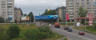
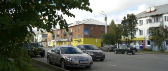
Zheleznogorsk has developed transport links. A142 highway passes through the city , which connects the M2 and M3 . It is laid across flat terrain and is a regular two-lane road.
In the eastern part of the settlement there is a single-track non-electrified railway line Orel-Lgov , on which the nearest station is Mikhailovsky Rudnik. It is the terminus for commuter trains coming from Orel. Transit passenger trains going to Lgov also pass through it.
Population[ | ]
| Population | |||||||||||
| 1959[9] | 1967[10] | 1970[11] | 1976[10] | 1979[12] | 1986[10] | 1987[13] | 1989[14] | 1992[10] | 1996[10] | 1998[10] | 2001[10] |
| 1897 | ↗19 000 | ↗30 953 | ↗57 000 | ↗65 280 | ↗79 000 | ↗81 000 | ↗85 192 | ↗90 400 | ↗94 900 | ↗96 300 | ↗98 200 |
| 2002[15] | 2003[10] | 2005[10] | 2006[10] | 2007[10] | 2009[16] | 2010[17] | 2011[10] | 2012[18] | 2013[19] | 2014[20] | 2015[21] |
| ↘95 528 | ↘95 500 | ↗96 200 | ↗96 400 | ↗97 436 | ↗98 069 | ↘95 049 | →95 049 | ↗95 827 | ↗96 563 | ↗97 601 | ↗98 756 |
| 2016[22] | 2017[23] | 2018[24] | 2019[25] | 2020[26] | 2021[2] | ||||||
| ↗99 683 | ↗100 671 | ↗100 740 | ↘100 499 | ↘100 446 | ↗100 554 | ||||||
As of January 1, 2022, in terms of population, the city was in 202nd place out of 1116[27]cities of the Russian Federation[28].
Sights of Zheleznogorsk
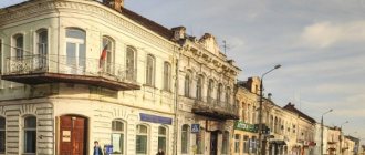
The city is rich in monuments reflecting its industrial purpose. Here you can find monuments dedicated to the excavator bucket, the first ore and the pioneer miners.
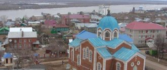
Over a dozen churches have been built in Zheleznogorsk, among which the Church of All Saints and the Holy Trinity Church .
history museum , which shows the main milestones in the history of the city, is of great cultural interest
On the territory of the Central City Park you can see the Memorial Sign to the Mikhailovsky Partisan Detachment.
History[ | ]
In 1950, an iron ore deposit was discovered on the territory of the Mikhailovsky district of the Kursk region, confined to the Kursk magnetic anomaly. On August 3, 1957, the Council of Ministers of the USSR adopted a resolution on the construction of a mine in this place. To service the quarry under construction, construction began on a workers' settlement for 10 thousand inhabitants. The site chosen for the construction of the village was a large buckwheat field to the west of the village of Chernyakovo[5].
The founding date of Zheleznogorsk is considered to be October 2, 1957 - on this day the construction of houses began on what is now Oktyabrskaya Street. By November 7, the first 2 two-apartment residential buildings were put into operation. At first, the working settlement was called Oktyabrsky
. On June 24, 1958, by decision of the Kursk Regional Council of Workers' Deputies, the village of Oktyabrsky was renamed Zheleznogorsk.
On September 7, 1959, the Zheleznogorsk secondary school, the future Gymnasium No. 1, opened[6].
On September 28, 1961, the village of Chernyakovo, the villages of Ermolaevsky and Chernyakovsky Gorki of the Razvetyevsky village council were included in the boundaries of the working village of Zheleznogorsk [7]. On May 28, 1962, the village was given the status of a city; at that time, 16.5 thousand people lived in it. On January 12, 1965, the Zheleznogorsk district was formed with its center in the city of Zheleznogorsk.
By 1970, more than 30 thousand people lived in the city, and there were 5 schools.
In 2008, the villages of Alekseevsky, Platonovsky, Khutorskoy, the villages of Trubicheno and Panino, and the village of Luzhki, which were previously part of the urban district of Zheleznogorsk, were annexed to the city. In 2015, these settlements received the status of city microdistricts[8].
In 2022, the city's population exceeded 100 thousand people.
Architecture and housing stock of Zheleznogorsk
On the map of Zheleznogorsk with houses you can find a wide variety of housing stock. In total, there are about 500 houses of different years of construction in the city. Most of them (32%) are houses that appeared in the 70s of the last century. The earliest buildings were erected in the 50s.
In the second decade of the 21st century, several dozen modern houses with comfortable apartments were built in the city. These include panel and prefabricated frame multi-apartment residential buildings,
main feature
When designing the city, engineers tried to preserve the natural beauty of the taiga as much as possible. Therefore, the old and new quarters of Zheleznogorsk are designed in such a way that there is greenery everywhere. There are no frequent buildings here, as in other cities; if you look at the streets from the neighboring island, it seems that the houses are adjacent to the taiga.
In addition, next to residential areas on a hill there are ski slopes of different heights and distances. The city was designed by Leningrad engineers, and the park was originally planned without a lake. But local residents, on their own initiative, cleared the floodplain under the reservoir and built dams. Now there is a park with ancient trees and the pearl of Zheleznogorsk - a beautiful and clean pond.
Economy and industry of Zheleznogorsk
A satellite map of Zheleznogorsk shows several gardening partnerships, an industrial zone and a quarry of the Mikhailovsky Mining and Processing Plant on the territory of the city. The latter has the status of a city-forming enterprise. Every third resident works there, and the local budget is 70% generated from the company’s tax revenues.
In addition, there is a brick and car repair plant, as well as a clothing factory. Also in the city there are about 700 small and medium-sized businesses.
Education[ | ]
- 8 secondary schools, 2 lyceums, 2 gymnasiums, 1 correctional school
- Zheleznogorsk Mining and Metallurgical College (former technical school)
- Zheleznogorsk Polytechnic College (formerly PU No. 16)
- Zheleznogorsk College of Service and Commerce (former PU No. 17)
- Zheleznogorsk Vocational School No. 18
- Zheleznogorsk Art College
- Zheleznogorsk branch of the Modern Humanitarian Academy
- Zheleznogorsk branch of Southwestern State University (Kursk)
- Zheleznogorsk branch of the Russian New University (RosNow)
- MOUDO "Zheleznogorsk Children's Art School"
- MOUDO "Children's Music and Choral School named after G. Struve."
- Municipal government institution of additional education “Station of Young Naturalists”
Sports[ | ]
- Gornyak Stadium
- Yunost Stadium
- Swimming pool "Neptune" (Oktyabrskaya st., 44)
- Pool "Albatross"
- Sports complex OJSC "Gotek"
- Skating rink "Yubileiny"
- Sports and Wellness Complex “Start”
- Military sports club "BU-DO"
From 1999 to 2012, the Magnit football club took part in the third division of the Chernozemye zone of the Russian Football Championship. In November 2012, it was announced that the management of MGOK OJSC intended to allocate funds annually for the football team to other sports, which is due to the low number of fans at home matches. Because of this, FC Magnit refused to participate in third division matches.
Notes[ | ]
- Number of residents of Zheleznogorsk population. Photos and maps
- ↑ 123
The permanent population of the Russian Federation by municipalities as of January 1, 2022 (Russian). Retrieved April 27, 2022. Archived May 2, 2022. - THE USSR. Administrative-territorial division of the union republics on January 1, 1980 / Comp. V. A. Dudarev, N. A. Evseeva. - M.: Izvestia, 1980. - 702 p. — P. 157.
- Order of the Government of the Russian Federation of July 29, 2014 No. 1398-r “On approval of the list of single-industry towns”
- Project “Quarterly Report”: Chernyakova | Directory of Zheleznogorsk (unspecified)
(inaccessible link). Access date: August 7, 2012. Archived October 20, 2012. - History of the municipal educational institution "Gymnasium No. 1" of the city of Zheleznogorsk, Kursk region
- Guide to the holdings of the State Archive of the Kursk Region | www.archive.rkursk.ru (unspecified)
. Archived on February 22, 2014. - Renamed microdistricts (undefined)
(inaccessible link). Date accessed: February 6, 2016. Archived December 11, 2022. - All-Union Population Census of 1959. The size of the urban population of the RSFSR, its territorial units, urban settlements and urban areas by gender (Russian). Demoscope Weekly. Access date: September 25, 2013. Archived April 28, 2013.
- ↑ 123456789101112
People's encyclopedia "My City". Zheleznogorsk (Kursk region) - All-Union Population Census of 1970 The size of the urban population of the RSFSR, its territorial units, urban settlements and urban areas by gender. (Russian). Demoscope Weekly. Access date: September 25, 2013. Archived April 28, 2013.
- All-Union Population Census of 1979 The size of the urban population of the RSFSR, its territorial units, urban settlements and urban areas by gender. (Russian). Demoscope Weekly. Access date: September 25, 2013. Archived April 28, 2013.
- National economy of the USSR for 70 years: anniversary statistical yearbook: [arch. June 28, 2016] / USSR State Committee on Statistics. - Moscow: Finance and Statistics, 1987. - 766 p.
- All-Union population census of 1989. Urban population (undefined)
. Archived from the original on August 22, 2011. - All-Russian population census 2002. Volume. 1, table 4. Population of Russia, federal districts, constituent entities of the Russian Federation, districts, urban settlements, rural settlements - regional centers and rural settlements with a population of 3 thousand or more (unspecified)
. Archived from the original on February 3, 2012. - The size of the permanent population of the Russian Federation by cities, urban settlements and regions as of January 1, 2009 (unspecified)
. Retrieved January 2, 2014. Archived January 2, 2014. - All-Russian population census 2010. Volume 1. Number and distribution of the population of the Kursk region (unspecified)
. Retrieved January 31, 2014. Archived January 31, 2014. - Population of the Russian Federation by municipalities. Table 35. Estimated resident population as of January 1, 2012 (unspecified)
. Retrieved May 31, 2014. Archived May 31, 2014. - Population of the Russian Federation by municipalities as of January 1, 2013. - M.: Federal State Statistics Service Rosstat, 2013. - 528 p. (Table 33. Population of urban districts, municipal districts, urban and rural settlements, urban settlements, rural settlements) (undefined)
. Retrieved November 16, 2013. Archived November 16, 2013. - Table 33. Population of the Russian Federation by municipalities as of January 1, 2014 (unspecified)
. Access date: August 2, 2014. Archived August 2, 2014. - Population of the Russian Federation by municipalities as of January 1, 2015 (unspecified)
. Access date: August 6, 2015. Archived August 6, 2015. - Population of the Russian Federation by municipalities as of January 1, 2016 (Russian) (October 5, 2018). Retrieved May 15, 2022. Archived May 8, 2022.
- Population of the Russian Federation by municipalities as of January 1, 2022 (Russian) (July 31, 2017). Retrieved July 31, 2022. Archived July 31, 2022.
- Population estimate of the Kursk region as of January 1, 2018 (unspecified)
(inaccessible link). Archived from the original on March 29, 2022. - Population of the Russian Federation by municipalities as of January 1, 2022 (Russian). Retrieved July 31, 2019. Archived May 2, 2022.
- Population of the Russian Federation by municipalities as of January 1, 2022 (Russian). Date accessed: October 17, 2022. Archived October 17, 2022.
- taking into account the cities of Crimea
- https://rosstat.gov.ru/storage/mediabank/bul_Chislen_nasel_MO-01-01-2021.rar Population of the Russian Federation by municipalities as of January 1, 2022 (1.85 Mb, 07/30/2021)
- Central Library Library (undefined)
. Archived from the original on December 11, 2014. - Official website of the municipal formation City of Zheleznogorsk
Geography
| Distance from Zheleznogorsk to the nearest major cities (by road)[7] | |||||||||
| St. Petersburg ~ 1129 km. Smolensk ~ 469 km. Bryansk ~ 226 km. | Moscow ~ 463 km. Kaluga ~ 299 km. | Tula ~ 283 km. Orel ~ 93 km. | |||||||
| Warsaw ~ 1060 km Berlin ~ 1639 km. | Lipetsk ~ 387 km. Voronezh ~ 341 km. | ||||||||
| Kyiv ~ 447 km. Odessa ~ 942 km. | Belgorod ~ 253 km. Kharkov ~ 329 km. Sevastopol ~ 1070 km. | Kursk ~ 110 km. Rostov-on-Don ~ 904 km. Sochi ~ 1465 km. | |||||||
Media[ | ]
Online publications:
- Information portal of the city of Zheleznogorsk https://zhel.city/
Printed publications:
- Weekly newspaper "Kursk Ore"
- Teleradio
- Radio "Iron FM"
- Weekly newspaper “Zheleznogorsk News”
- Weekly newspaper "Echo of the Week"
- Weekly newspaper of free advertisements “Making Choices”
- Weekly newspaper "City newspaper"
- Weekly newspaper “Zheleznogorsk Panorama”
- Weekly newspaper "Zhelezka"
Radio:
- 92.8 Humor FM
- 95.8 Love Radio
- 96.9 Traffic radio
- 98.6 Radio Dacha
- 99.0 Iron FM
- 100.2 Europe Plus
- 100.6 Radio 7 on Seven Hills
- 101.9 Radio Chanson
- 102.7 Autoradio
- 103.2 Russian radio
- 105.2 Radio Course
A television:
- 25 TVK - DVB-T2 digital (1mp)
- 27 TVK - DVB-T2 digital (2mp)
- TNT / TRC "Zheleznogorsk" Cable broadcasting