Sights of Zarinsk.
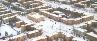
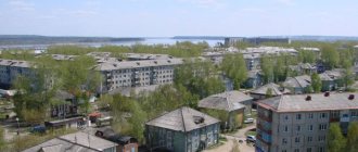
The city of Zarinsk today. The city of Zarinsk is located in the Altai Territory, 100 km northeast of Barnaul. The Zarinsky district includes 50 settlements. Geographically located on the Biysk-Chumysh Upland, on the Chumysh River (a tributary of the Ob). This is a very young city, it was founded in 1979. Large transport hub - there is a railway station.
The area of the city is 79.16 km/sq., the population is 46 thousand people.
Book a hotel in Zorinsk on Booking.com =>>
Historical reference
The city arose by merging the regional center of Sorokino with the Zarinskaya railway station.
- The village of Sorokino on the banks of the river. Chumysh has been mentioned in historical sources since 1748. According to legend, it was founded by a wanderer nicknamed Soroka. Since the 18th century By decree of Elizaveta Petrovna, the peasants of the village were assigned to the Demidov copper smelters in Barnaul as seasonal labor.
- In 1920, not far from the regional center of Sorokino, the “Dawn of Communism” commune was formed. Soon the communards were shot with fists, but the memory of the commune was preserved by the name of the future city - Zarinsk.
- In 1953, the Altai-Kuzbass railway line was built near the village of Sorokino, and the Zarinskaya station with a workers’ settlement appeared.
- 1968-1981 – the plan for the construction of the Altai Coke and Chemical Plant, which gave rise to the city of Zarinsk, is being implemented.
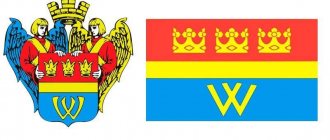
- In 2000, the coat of arms of the “city at dawn” appeared: against the background of a blue sky, a golden lark soars above the rays of the rising sun - the symbolism reflects the aspiration of the residents to the future.
Barnaul
From a stone oven to a glass mug
The coat of arms of Barnaul has the shape of a shield. On a blue background, among silver rocks on green grass, there is a smoking red blast furnace with a golden fire inside, signifying melting. Above the stove there is a white galloping horse - a symbol of the main transport force, which means moving forward and overcoming obstacles.
A story that failed...
The Barnaul silver smelter operated until 1893 - and was closed due to a decrease in smelting volumes and the cost of metal. Later, a sawmill was located on its premises, and in 1942, a match factory evacuated from the Gomel region was opened, which was declared bankrupt in February 1998.
Real coats of arms of the cities of the Altai Territory.
Altapress.ru.
The last match was released there in 2001. Today, the monument of urban planning and architecture, despite attempts at restoration and renovation, is in a deplorable state.
At the same time, in recent years, Barnaul, having lost its powerful old industry, has experienced a real boom in the construction of shopping centers. Today their total area has probably already exceeded a million square meters, which is reflected in short parables: “Soon we will live in shopping centers.” Another feature of today’s Barnaul is the abundance of beer stores, where revenue reaches “industrial” proportions.
As for the white horse, it also ceased to be a symbol of the main transport force.
Alternative coat of arms of Barnaul.
Altapress.ru.
New coat of arms
A burning match broken in half among shopping centers and a mug of beer.
Zarinsk on the map of Russia: geography, nature and climate
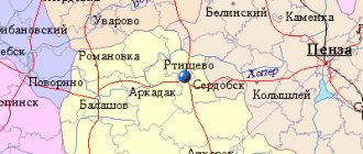
Zarinsk is located in the northeast of the Altai Territory, on the Chumysh River , which is a right tributary of the Ob River . The distance to the capital of the region - Barnaul - is 100 km. Time in the region is Krasnoyarsk, the difference with Moscow is 4 hours.
Altai is located inland, the climate here is sharply continental. The average temperature in January is -19°C Celsius, in summer the air heats up to +20°C Celsius, but there is little rain. The landscapes of the Zarinsky district are diverse:
- areas of black pine-fir taiga on the Salair ridge (it runs through the area in an arc from north to south, on the satellite map of Zarinsk it has a dark green color);
- forest-steppe expanses with birch groves - groves;
- thickets of willow, bird cherry, and hawthorn along the banks and floodplains of rivers;
- The forest-steppe zone is mainly plowed and sown with grain and fodder crops.
There are a lot of fish in rivers and lakes, and mushrooms in forests. Not far from Zarinsk there is the Red Mountain Nature Reserve, a deposit of colored clay.
Aleysk
Canned beets with pasta, butter and sugar
The coat of arms of Aleysk has the shape of a blue shield, in the center of which there is a golden ear and gears, reflecting the development of industry and agricultural achievements. In the lower part there is an elevator, to which the sown fields approach in golden rays. The coat of arms was developed in Soviet times, it was made in the spirit of the era of industrialization.
A story that failed...
Aleysk was founded in 1913 on the site of the village of Maloponyushevo, which arose back in 1834, and at first it was a station village on the West Siberian Railway. Gradually, the station grew into a developed city with a large cargo-passenger hub, which contributed to the development of enterprises in the processing and food industries. Already in 1926, a mechanized butter factory was launched, which used steam engines and other innovations. The Aleysky sugar factory appeared in 1931, it was mothballed in 2007, and now there is silence there. And in 1932 they built a milling plant, where they built an elevator and a grain dryer with warehouses.
Alternative coat of arms of Aleysk.
Altapress.ru.
The city is located among large agricultural areas, which connected its economy with the processing industry. Among the largest enterprises are Aleyskzernoprodukt, which produces cereals, flour, pasta, vegetable oil and animal feed, as well as Aleysk Meat Processing Plant and Aleysk Butter and Cheese Plant.
New coat of arms
In the center there are ears of wheat curved in the shape of a dollar sign. They are complemented by sticks of sausage and cheese.
Routes on the map of Zarinsk. Transport infrastructure
Zarinsk is connected to the regional center and settlements of the region by a network of roads and a railway line.
Rail routes:
- The railway connection between Zarinsk and Kuzbass is of industrial importance; raw materials for the coke plant are delivered from there.
- 10 passenger trains from Barnaul to Kemerovo, Novokuznetsk, Abakan run through Zarinskaya station
- Electric trains go to Barnaul 6 times a day.
Highways:
- The regional center is directly connected to the capital of the region by the Zarinsky Highway ; motorists call it a “minefield”. Buses to Barnaul run 10-12 times a day.
- The highway leads to the south of the city to Togul, and to the north – to Zalesovo.
- Moving to Zalesovo, you can go onto the more comfortable Altai-Kuzbass highway. To the north along it the road leads to Belovo, Kemerovo; to the south - to the federal highway P 256 Novosibirsk-Biysk-Gorno-Altaisk. (“Chuysky tract”). There are daily flights to Novosibirsk from Zarinsk.
City transport is represented by 5 routes, all of them start from the Station and go to:
- Depot,
- State Farm,
- Timber mill,
- village Dawn,
- village Mironsky.
Biysk
A new stronghold of science around an old fortress
The coat of arms of Biysk has the shape of a shield and is divided into two equal parts horizontally. In the upper part, on a green background, there is a white horse galloping to the left. At the bottom on a blue background is a mountain mine on a golden mountain.
A story that failed...
The coat of arms of Biysk was granted by a personal decree of Emperor Alexander I in 1804. The image of the mine appeared only because at that time it was a district town belonging to the Altai Mining District (Imperial Chancellery of the Kolyvan-Voskresensk Mining Plants). In fact, the mines were not developed here on a large scale. And the presence of the horse is explained by the fact that the district was formally part of the Tomsk province, so the white horse on a green background is a reference to the coat of arms of the provincial city of Tomsk (vicerious).
Naturally, Biysk has long needed its own coat of arms, which would not collect alien elements, but would become native - from the point of view of the history of the city, which was a fortress, then became a city, then a village, then again a city, then again a village, and then back to the city.
Alternative coat of arms of Biysk.
Altapress.ru.
Today Biysk, as one of the scientific and industrial centers of Southern Siberia, has the status of a science city. The city is home to the largest Russian manufacturer of dietary supplements, Evalar, and two enterprises producing explosives.
New coat of arms
A mountain of open books with an explosion at the very top and an energy bar for weight loss floating above it.
Sights of the city of Zarinsk
On the map of Zarinsk with houses you can find all the main attractions of the city and explore them in 1 day.
- Settlement Museum , where 10 thousand exhibits are presented: from archaeological finds to works of local artists. The museum building itself is an architectural monument of the early 20th century (Lenin St. - 25).
- The Memorial of Glory with the Eternal Flame and the Alley of Heroes; the museum building contains relics of the war years. Nearby there is a monument to internationalist soldiers who died in Afghanistan (Karl Marx Street - 8).
- Obelisk “Field of the Communards” (2 km from the city along the Zarinsk – Barnaul highway).
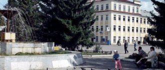
- The Fountain of Happiness , the Tree of Lovers, the striking clock, and the milestone in memory of Dostoevsky are located in the modern city center. (microdistricts No. 1-2, intersection of Stroiteley Avenue with Metallurgov Street).
- Church of the Ascension (Taratynov St. -1a).
- The Stroitel House of Culture is an example of 20th-century architecture, with stained-glass windows on the windows and metal sculptures on the roof (25 Party Congress Street - 7).
Yarovoe
Through the thorns of bankruptcy to the stars of show business
Yarovoy's coat of arms is a shield. On it, in a green field, a ball is depicted, crossed with gold and azure, burdened with wavy silver belts, rays emerge from the ball.
A story that failed...
Yarovoye became a city in 1993, although the point of its foundation can be considered the emergence of a village of chemists (the bromine plant was evacuated here from Perekop in 1943, which later became the Slavgorod Chemical Plant). Initially, the village was subordinate to Slavgorod, now it is a city of regional subordination.
The city-forming enterprise was the plant, renamed Altaikhimprom, which produced paints and varnishes, decontamination agents, anesthetics and household chemicals. But this enterprise went through the stage of bankruptcy, and Altai Chemical Industry was created on its basis. Today Yarovoye is primarily a resort town.
Alternative coat of arms of Yarovoy.
Altapress.ru.
New coat of arms
Liquid pours out of a tilted flask, forming a lake in which tourists swim and relax. Olga Buzova entertains tourists.
Main streets of Zarinsk
Using the street map of Zarinsk, you can trace how the main highways of the city connect its microdistricts.
- St. Molodezhnaya (4 km) – starts from Stroiteley Ave. in the 1st microdistrict, passes by the Lnyschenskoye tract to the street. Zarinskaya in the village. Sorokino.
- Ave. Stroiteley (2.3 km) departs from the Zarinsk-Barnaul highway, stretches east through the central microdistricts, ends at the street. Youth. Along the highway there are gas stations, a Central Department Store, the Breeze shopping center, and the Pancake Cafe.
- St. Taratynova (3 km) starts from the Zarinsk-Barnaul highway, runs along the railway through the 3rd and 4th microdistricts. There are hotels at Zarinskaya station and in the 3rd microdistrict.
- St. Green (2.5 km) departs from the Zarinsk-Kytmanovo highway and stretches to the east, separating the residential areas of the Privokzalny microdistrict from the industrial zone of the city, turns into st. Victory.
- St. Gorky goes from the bridge over the river. Chumysh along the right bank of Sorokio past numerous shopping centers, goes to the city cemetery and further to the Zarinsky tract in the direction of Zalesovo and the Altai-Kuzbass highway.
- St. Zarinskaya (2 km) runs from the street. Molodezhnaya in the south of the left bank part of the village. Sorokino to the bridge over the river. Chumysh. On the territory of the North-Eastern DSU there is a sculpture of the Dz-6 grader.
Notes
- ↑ 12
www.gks.ru/free_doc/doc_2016/bul_dr/mun_obr2016.rar Population of the Russian Federation by municipalities as of January 1, 2016 - Order of the Government of the Russian Federation of July 29, 2014 No. 1398-r “On approval of the list of single-industry towns”
- [www.altai-koks.ru/company/history/ History of OJSC Altai-koks]
- [demoscope.ru/weekly/ssp/rus59_reg2.php All-Union Population Census of 1959. The size of the urban population of the RSFSR, its territorial units, urban settlements and urban areas by gender] (Russian). Demoscope Weekly. Retrieved September 25, 2013. [www.webcitation.org/6GDOghWC9 Archived from the original on April 28, 2013].
- ↑ 12
www.MojGorod.ru/altajsk_kraj/zarinsk/index.html People's encyclopedia “My City”. Zarinsk - [demoscope.ru/weekly/ssp/rus89_reg2.php All-Union Population Census of 1989. Urban population]. [www.webcitation.org/617x0o0Pa Archived from the original on August 22, 2011].
- ↑ 1234567891011121314
ak.gks.ru/DBINET_DG/DBInet.cgi?pl=171205 Resident population as of January 1 - [akstat.gks.ru/wps/wcm/connect/rosstat_ts/akstat/resources/b69359804ea235f088bfb9189c529309/Volume 1. Number and distribution of population.pdf Results of the 2010 All-Russian Population Census for the Altai Territory. Volume 1. Number and distribution of population]. Retrieved March 6, 2015. [www.webcitation.org/6WpRPTbQK Archived from the original on March 6, 2015].
- ↑ 12
ak.gks.ru/DBINET_DG/DBInet.cgi?pl=171105 Population by municipalities as of January 1 (including by settlements) according to current records - [www.gks.ru/free_doc/doc_2013/bul_dr/mun_obr2013.rar Population of the Russian Federation by municipalities as of January 1, 2013. - M.: Federal State Statistics Service Rosstat, 2013. - 528 p. (Table 33. Population of urban districts, municipal districts, urban and rural settlements, urban settlements, rural settlements)]. Retrieved November 16, 2013. [www.webcitation.org/6LAdCWSxH Archived from the original on November 16, 2013].
- [akstat.gks.ru/wps/wcm/connect/rosstat_ts/akstat/resources/db0b3b8042d06d268d4bed553db9bdfa/prenumber.htm Altai Territory. Preliminary population estimate as of January 1, 2014 and average for 2013]. Retrieved May 14, 2014. [www.webcitation.org/6PZJQt0dD Archived from the original on May 14, 2014].
- [www.gks.ru/free_doc/doc_2015/bul_dr/mun_obr2015.rar Population of the Russian Federation by municipalities as of January 1, 2015]. Retrieved August 6, 2015. [www.webcitation.org/6aaNzOlFO Archived from the original on August 6, 2015].
- taking into account the cities of Crimea
- [www.gks.ru/free_doc/doc_2016/bul_dr/mun_obr2016.rar Population of the Russian Federation by municipalities as of January 1, 2016. Table “31. Population of cities and towns by federal districts and constituent entities of the Russian Federation as of January 1, 2016.” RAR archive (1.0 MB)]
- [www.tourprom.ru/country/russia/zarinsk/all_attr/ Monument to the Commonwealth with Afghanistan]
Economy of Zarinsk
The main enterprise of the city is the Altai-Koks coke-chemical plant; its products are exported to Europe and Asia. Construction companies:
- "Metallurg-Cemremont"
- Reinforced concrete products plant,
- OJSC "Rost" produces reinforced concrete structures and materials for road construction.
The food industry is represented by the Kholod dairy processing plant and an elevator. Zarinsk is a single-industry town with single-profile economic development; there is a tendency for the standard of living to decline. Environmental problems are acute. At the regional and regional levels, a search is underway for ways to solve these problems.
Rubtsovsk
The tractor ran over it twice and scattered the pasta.
The coat of arms of Rubtsovsk has the shape of a shield, in the middle of which, against the background of a solar circle, is a part of a gear, symbolizing the engineering profile. Inside the solar circle there is a scroll on which the founding year is marked. The blue ribbon dividing the shield diagonally symbolizes the water artery - the Alei River. In the upper left part, against the background of a blue sky, there is a falcon soaring over a wheat field on which a tractor is located - the brainchild of the Altai Tractor Plant.
A story that failed...
The Altai Tractor Plant appeared in 1941, when a decision was made to hastily evacuate equipment from the Kharkov Tractor Plant and the Odessa Agricultural Engineering Plant to Rubtsovsk. And the company actually began to “die” in 2007: a slow bankruptcy, which led to reorganization, and then to bankruptcy. The property was divided for a long time, the plant remained idle and was sold in parts as building material until it turned into a ruined wasteland.
Now some of the largest enterprises in the city are a timber processing plant, an agro-industrial plant producing flour, pasta, cereals and more, and a dairy plant owned by the transnational corporation PepsiCo.
Alternative coat of arms of Rubtsovsk.
Altapress.ru.
Rubtsovsk is also known for its four large correctional colonies. And a few kilometers from the city there is an abandoned airport, plans for the resurrection of which have been discussed for many years.
New coat of arms
A wheel of cheese against the background of the sky with planes flying over a field on which a broken tractor stands. There is barbed wire running through the coat of arms, symbolizing hope for life.
Slavgorod
They evacuated so the children could take it apart.
The coat of arms of Slavgorod is a shield on which, as a symbol of glory, a laurel branch with leaves of variable colors is depicted; the seeds on the branch are golden in a green field, and red in a golden field.
A story that failed...
Slavgorod was founded in 1910 and received city status in 1914. Officially, the founder is considered to be the great Russian reformer Pyotr Stolypin, who, while making an inspection trip along the Trans-Siberian Railway, visited the settlement and said: “There will be a glorious city here.” Over the course of several years, railway workshops, an iron foundry, and enterprises for processing agricultural products were created in Slavgorod.
At the beginning of the war, a forging and pressing equipment plant was evacuated here from Serpukhov, which was liquidated in 2017. A brewery had been operating since 1918, but it was also liquidated. The history of the radio equipment plant also began in 1918, and it is a little more optimistic. After the war, a dairy and canning plant and a furniture factory were launched in the city, as well as a meat processing plant and a clothing factory, which also died out for a long time.
Alternative coat of arms of Slavgorod.
Altapress.ru.
New coat of arms
On one side of the laurel branch there is a black and white TV and a skein of thread, and on the other there is a mug of milk and a sofa as a symbol of hope for a bright future.
Miner
Lead was melted to a bankrupt and unprofitable state
The city does not have an official coat of arms, but sometimes they use an image that previously symbolized the Loktevsky district. The picture shows the Altai mining and processing plant.
A story that failed...
Gornyak became a city in 1969, although its history began with the Zolotushinsky polymetallic mine opened in 1751, near which a miners’ settlement appeared in 1942. The basis of the city's economy was the extraction and processing of polymetallic ores, and the largest enterprise was the mining and processing plant, which also produced copper, zinc, lead, tin and aluminum.
in the mid-90s it was declared unprofitable and went bankrupt. In addition, the mine, which occupied one of the first places in the USSR in terms of labor productivity, was flooded. A similar fate befell almost all representatives of the old large industry in the city - they were either liquidated or on the brink. Although the resource potential of the territory is diverse.
Alternative coat of arms of Gornyak.
Altapress.ru.