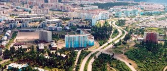
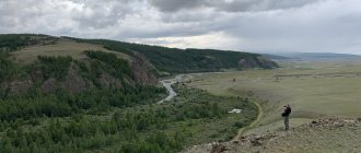
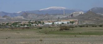
NERYUNGRI, a city in the Russian Federation, Republic of Sakha (Yakutia), is located on the northern spurs of the Stanovoy Range, near the Amur-Yakutsk highway, 740 km south of Yakutsk. Railway stations: freight - Berkakit, passenger - Neryungri. Airport. Population 72.6 thousand people (2001). Founded in 1975. City since 1975.
Coat of arms of the city of Neryungri.
The coat of arms of the city of Neryungri and Neryungri district was adopted on October 29, 2003. In an azure (blue, light blue) field there are three golden hitching posts in the form of carved pillars. On the sides there are five golden fish (graylings). On top are seven silver Yakut diamonds.
Coat of arms of Neryungri. 1984
Coat of arms of Neryungri. 1984 The heraldic shield depicts a coal seam, a dump truck, a trolley, hitching posts and a gear above them.
STANOVOY RIDGE , a system of mountain ranges in the Russian Far East. It stretches for 700 km from the middle reaches of the Olekma River to the sources of the Uchur River (a tributary of the Aldan). Height up to 2412 m. Watershed of the Arctic and Pacific oceans. Deposits of gold, rare metals, iron ores.
Neryungri. Main square.
Center of the South Yakut coal basin. Coal mining (SUE "Yakutugol"). Processing plant for the production of coking coal concentrate. Neryungri State District Power Plant. Factories: mechanical repair, electrical repair, dairy, bakery. House-building plant. Founded as a city in connection with the development of the Neryungri coal deposit. Scientific, educational and cultural institutions: South Yakut geological exploration expedition. Branch of Yakut State University. Museum of the history of construction of the South Yakutsk TPK.
Neryungri. Temple of the Kazan Icon of the Mother of God.
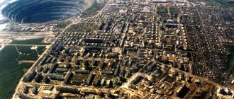
MIRNY , a city in the Russian Federation, Republic of Sakha (Yakutia), is located on the border of the Vilyuisky and Prilensky plateaus, on the river. Irelyakh (Vilyuy river basin), 1193 km from the Lena railway station, 820 km west of Yakutsk. Connected by road with the city of Lensk (on the Lena River, 230 km south of Mirny). Airport. Center of Mirninsky ulus. Population 36.5 thousand people (2001). Founded in 1955. City since 1959.
Flag of the city of Mirny.
Flag of the city of Mirny . On the blue part of the panel in the center there is a stylized image of a diamond with two white edges and two faces in the color of the panel with a white border. On the green stripe are two small stylized white diamonds, separated into four sides by green lines.
| The coat of arms of the city of Mirny was adopted on May 12, 1989. Later, on June 9, 2004, the coat of arms was approved with minor changes. “In an azure field there is a silver key with two bits, instead of an eye there is a larch cross with a rhombus in the middle, above a four-step recessed green tip, thinly bordered with silver and burdened with two rhombuses of the same metal.” |
Mirny is the center of the diamond industry. Food industry enterprises, building materials plant. It arose in connection with the development of a diamond deposit (the Mir kimberlite pipe), from which it received the name Mirny. Scientific and cultural institutions: Research and Design Institute of the Diamond Mining Industry; historical and production museum.
Peaceful. Trinity Church.
ALDAN , a city in the Russian Federation, Republic of Sakha (Yakutia), is located on the Aldan Highlands, in the river basin. Aldan (right tributary of the Lena River), on the Amur-Yakutsk highway, 215 km north of the Neryungri railway station, 290 km north of the Berkakit railway station, 530 km south of Yakutsk. Airport. Center of Aldan ulus. Population 21.2 thousand people (2001). Founded in 1923. City since 1939.
| The coat of arms of the city of Aldan was adopted in 1984. The shield is divided horizontally by a blue wavy belt, at the top on a red field there are three stylized golden hills and the Moon in the form of a bezant (ball) hemisphere dissected into blue on the right and golden on the left. Below on the green field is an ancient Yakut rock painting of gold color. |
The center of the mining region (gold and mica mining) of Southern Yakutia. Metalworking. Production of building materials (Aldan Woodworking Plant LLC).
Aldan. Panorama of the winter city.
It was formed in 1939 from the mining village of Nezametny (1923), which arose among the taiga in connection with the discovery of rich gold deposits.
There is a local history museum in the city. A monument to the discoverers of the Aldan gold deposits was erected.
| UDACHNY , city (since 1987) in the Russian Federation, Yakutia, 550 km northwest of Mirny. Population 17.8 thousand people (2002). Diamond mining. Mining and processing plant. It emerged in 1968 as a village in connection with the discovery of the Udachnaya diamond pipe. |
TYNDA , a city in the Russian Federation, Amur region, is located on permafrost in the valley of the river. Tynda (Amur River basin) and Getkan (Zey River basin). Large railway junction. Airport. District center. Population 45.6 thousand people (2001). Founded in 1917. City since 1975.
Coat of arms of Tynda.
The logging industry has been developed (OJSC Timber Logging Complex Tyndales). Enterprises for servicing the Baikal-Amur railway. Food industry (bakery, meat and dairy plant).
Tynda. Railway station.
Since 1928, it developed as a working settlement called Tyndinsky to serve the Amur-Yakutsk highway. During the construction of the Baikal-Amur Mainline, it became one of the strongholds of construction, the administrative center for the construction and operation of this railway. In 1975 it received the name Tynda.
Tynda. Panorama of the city.
Tommut , in the Aldan region of Yakutia, 451 km south of Yakutsk. Located in the zone of distribution of perennial rocks, in the north of the Aldan Highlands, on the river. Aldan, the right tributary of the river. Lena (pier), on the Amur-Yakutsk highway, 87 km northeast of Aldan (airport), 280 km from the Neryungri railway station. Population 9.9 thousand people (1992; 6.4 thousand in 1979). The city was founded in 1925 in connection with the construction of the Ukulan pier on the river. Aldan. It was a transshipment base for the developing gold mining industry of the Nezametny mine. In the early 1940s. hunter V.N. Zakharov discovered a deposit of mica - phlogopite (insulating material) on the Emeldzhak spring in the den of a killed bear. Mining has been carried out since 1942. In modern T.: mining, timber industry; production of building materials. Under construction (1994) Baikal-Amur railway from Berkakit station to T. Monument to V.N. Zakharov.
TIXI , an urban-type settlement (since 1939), the center of the Bulunsky district in Yakutia, 1270 km (by air) north of Yakutsk. It is located in a permafrost zone. Seaport on the shore of Tiksi Bay (Laptev Sea), near the river delta. Lena (Bykovskaya channel). Airport. Motor ships ply for navigation along the Lena between T. and Yakutsk. The climate is harsh. There are up to 120 days with blizzards per year. Average temperatures in January are -35AC, in July 11AC. Winter lasts 8 months, summer - 2 months. From May 10 to August 2 - polar day, from November 17 to January 25 - polar night. Population 11.6 thousand people (1990; 9.9 thousand in 1979). The bay was first put on the map of the northern coast of Russia in 1739 by Dmitry Laptev under the name Gorelaya Bay; since 1823 it has been called Tiksi (translated from Yakut - a place where you can land on the shore). In the vicinity of T., in the Lena delta, there were NKVD camps. In 1934, a port was built on one of the most inaccessible sections of the Northern Sea Route. A modern port is a well-equipped enterprise with a motor vehicle fleet and a port fleet: cargo is transshipped from sea vessels for settlements on the banks of the Khatanga, Olenek, Yana, Indigirka, and Kolyma rivers. The highest cargo turnover of the port was recorded in 1987 - 850 thousand tons during a short navigation. Ship repair base. In T. - services of the Northern Sea Route. Arctic Shipping Company. Laboratory of the Institute of Cosmophysics, directorate of the State Committee for Hydrometeorology, directorate of Tiksistroy. Production and technical (national fur clothing, souvenirs). People's Museum of the Arctic Shipping Company (two departments: an art gallery and a department of the history of development of the shores of the Central Arctic). Monument to political exile M.I. Brusnev. Near T. - polar station (since 1932); 45 km from T., on the northern coast of the Bykovsky Peninsula, there is a fish factory.
SREDNEKOLYMSK , regional center in Yakutia, 1485 km (by air) northeast of Yakutsk. It is located in the Kolyma Lowland, in the zone of permafrost. Pier on the left bank of the river. Kolyma, at the confluence of the river. Ankudinka. Airport. Population 4.9 thousand people (1992; 538 people in 1897; 3.2 thousand in 1979). Founded in 1644 by the Cossacks as a fort (called Yarmanka), in 1775 it was renamed the city of S. - the center of the Kolyma Okrug. S. was a place of exile; Decembrist N.S. Bobrishchev-Pushkin and others settled here. In the 19th century. S. is a district city. At the end of the 19th century. in S. there were 147 houses (including 53 residential), 22 yurts, 12 trading establishments, a wooden church, a parochial school, and a small hospital were opened. Residents were engaged in fishing, fur trading, bird hunting, and collecting mushrooms and berries. In modern S. there is a meat and dairy plant, an oil depot, and other enterprises. In the area there is fur fishing, fur farming (including breeding of silver-black foxes), fishing, and livestock farming (cattle, horses, deer). Museum of Local Lore (founded in 1921 as a museum on a voluntary basis; in 1989 transformed into the regional local history branch of the Yakut United Museum of History and Culture of the Peoples of the North). The city is divided by the river. Ankudinka in two parts. Monuments: the first discoverers of the river. Kolyma and the founders of the city; gravestone monument to the victims of the Kolyma exile; victims of the Civil War.
Basic information
The Republic of Sakha (Yakutia), or, as it was then called, the Yakut Autonomous Soviet Socialist Republic, was formed in the first years after the establishment of Soviet power in the region. It is the largest administrative-territorial unit, but in terms of population density it occupies one of the last places in the Russian Federation. At the same time, its land is incredibly rich in natural resources, which, if used correctly, can become the source of a real breakthrough in the economic sphere of the republic.
Yakutia borders the Chukotka Autonomous Okrug, Magadan, Irkutsk and Amur regions, Khabarovsk, Krasnoyarsk and Transbaikal territories. In addition, in the north its shores are washed by the East Siberian Sea and the Laptev Sea.
Sakha (Yakutia): capital
On the vast territory of the republic there are only a little more than two dozen cities and towns. Among them, the main one is the capital of Yakutia. This is the city of Yakutsk, where 294 thousand people live, most of whom belong to the indigenous nationality. It consists of 8 districts, which also include seven suburban villages.
In 2010, the capital of the Republic of Sakha (Yakutia) was included in Forbes magazine's list of the twenty best cities in Russia for business, in which it took thirteenth place.
Why go to Batagay
Most tourists who reach Batagay say that there is nothing to do there. However, if you are interested in the aesthetics of the real Russian outback, then it’s worth taking a walk around the city, and at the same time visiting the geological museum of JSC Yangeology. However, most travelers come to Batagai for its surroundings.
Pointer to Batagai
Batagaika
Near the city there is “Batagaika” - a huge “pit”, or as it is also called a “crater”, where you can very clearly see what permafrost is. In fact, this is neither a crater nor a pit, but a fault formed in the last century, when forests began to be actively cut down in those places for the construction of the city. The earth literally opened up along a small, barely noticeable stream, the sun warmed the walls and widened the rift. Now its width reaches 700 meters, length - about a kilometer, depth - from 45 to almost 100 meters. Every year the fault increases by several meters.
Fault near Batagai
At the edges of the giant fault, scientists examine layers from different times and claim that now, descending to its bottom, you can travel back almost 200 thousand years. In these same places, “mammoth hunters” find tusks and skeletons of animals that lived in these areas tens of thousands of years ago: not only mammoths, but also horses, bison, and wolves. By the way, this business is quite profitable: the price per kilogram of mammoth tusk on the “black” market reaches 25-30 thousand rubles, the weight of one tusk is 40-60 kilograms.
Being near Batagaika, you can hear the earth breaking: strange loud sounds are constantly heard in the “crater”, something between a crash and gunshots.
You can get to the fault by taxi. It is about 7 kilometers from the city, that is, it is better to take a car for a couple of hours (it costs about 500 rubles per hour) in order to get there calmly, walk about a kilometer to the fault, look at it, listen and return. If you plan to descend into the “crater” and walk along the bottom, allow much more time. Please note that there are no stairs there, the soil is slippery, so you need to do this very carefully.
Fault-crater Batagaika
Mount Kester
Approximately 65 kilometers from Batagay, near Mount Kester, the buildings of YanLager are preserved - one of the camps of the Gulag system, in which several thousand prisoners mined tin in the 40s of the last century. In total, during the Stalin era, there were 105 camps on the territory of Yakutia, but now most of them are practically inaccessible, while this can be reached by hiring a car (this will cost about 12-15 thousand rubles, because the road is very bad).
Many buildings have been destroyed, but some can still be seen, as can the road on the rock along which prisoners transported wheelbarrows of ore. There is a memorial slab in the middle of the cobblestones.
Betenkes
About 50 kilometers from Batagay is the village of Betenkes, where a very good paleontological museum was opened several years ago, which everyone who comes to this area is advised to visit. The museum houses rare finds - bones of ancient animals found nearby. A taxi to Betenkes will cost 3000-4000 rubles.
History of Yakutsk (briefly)
In 1643, the Lensky fort, founded by centurion Pyotr Beketov 20 years earlier, was moved to the territory of the modern city. At the same time, it was renamed Yakutsk, and also proclaimed the administrative center of the entire Lena region. Despite this, for a long time the city more closely resembled a large settlement, and its development began only in 1907, when, by a personal royal decree, I. Kraft was appointed governor there. By his order, the capital of Yakutia was electrified and telephoned, and the first museum was opened there.
How to get to Batagay
All year round you can fly to Batagai by plane from Yakutsk by air. Round-trip tickets cost about 20-35 thousand rubles. Travel time is 1.5-2 hours.
You can also get to Batagai by car at the end of winter and spring, but you don’t need to: the “winter road” starts operating - a route that exists only in winter. The distance from Yakutsk to the main city of the region is 1068 kilometers. The road is not particularly good, and therefore the entire journey will take more than three days.
By the way, winter in these places lasts 7 months, and spring comes at the end of May, when green shoots appear, and by the end of September the ground is covered with snow again.
Architectural sights of Yakutsk
As already mentioned, the capital of Yakutia was founded more than 370 years ago, so you can see many different historical and cultural monuments there. In particular, in the Old Town area you can see many ancient buildings and their modern reconstructions, giving an idea of what Yakutsk looked like 100-200 years ago. In general, it is considered the best place for walking excursions; even the sidewalks and roadways are paved with chocks. Therefore, tourists remember the capital of Yakutia as a place where they walked along “wooden” streets.
Why go to Verkhoyansk
Verkhoyansk is one of the coldest cities in the Northern Hemisphere. Local authorities decided that this could become a tourist “trick” and installed a memorial sign stating that Verkhoyansk is a “pole of cold” and give “diplomas” to visitors to this place.
Verkhoyansk - Pole of Cold
Indeed, this is the coldest place in Yakutia, where, due to the sharply continental climate, there is a huge temperature range and very little precipitation. In winter, the usual air temperature is -38--48 degrees.
Do you, like me, remember from school that the “pole of cold” and the frostiest place on Earth is Oymyakon? This village, indeed, tried to retain its former glory and compete with the city, but the authorities of Yakutia not so long ago gave the palm to Verkhoyansk. They motivated this by the fact that it was in Verkhoyansk in February 1892 that the lowest temperature outside Antarctica was recorded - -67.8 degrees. Whereas in Oymyakon in February 1933 they measured -67.7 degrees. However, some scientists agree. They do not agree that Verkhoyansk won, because the average annual temperature is 0.3 degrees lower in Oymyakon.
You will be told in more detail about why Verkhoyansk is the coldest place on the planet in the local history museum, which is called “Pole of Cold” (entrance ticket - 200 rubles).
If you have a lot of time, you can get to know this region more thoroughly. For example, visit natural monuments: a sacred place of the northern peoples and one of the highest mountain peaks of the Verkhoyansk region “ Mother Mountain ” (Mount Ulakhan-Ynnakh ) and “ Kisilyakh Kihileekh Mountains ) with bizarre remains that from a distance look like a group of people, a resource reserve “ Tuostakh ” (Tuostakh locality), where you can meet rare animals and see a variety of plants.
Monuments
The capital of Yakutia, Sakha, whose photos will decorate your travel album, will also be of interest to lovers of monuments and sculptural compositions. In particular, there you can see a unique statue of a mammoth, which was installed in the courtyard of the Institute of Permafrost Science, on the site where the well-preserved corpse of this animal was found. Another image of a prehistoric relative of modern elephants is located next to the new building of the Yakut circus. Moreover, on the back of the mammoth there are two gilded acrobats. In addition, in the capital of the republic you can see a monument to friendship, depicting the first family created by a Russian and a Yakut woman, and their mixed-breed baby. Like all citizens of the former USSR, residents of Yakutia took part in the defense of their great Motherland during the Second World War. In memory of those who never returned from the battlefield, the Victory Stele was erected.
Olekminsk
Olekminsk , a regional center in Yakutia, 651 km southwest of Yakutsk. Located in the south of the Lena Plateau. Pier on the left bank of the river. Lena. Airport. Population 10.6 thousand people (1992). Founded by a detachment of Yenisei Cossacks under the command of P. Beketov in 1636 as a small fort opposite the mouth of the river. Olekma, then moved 12 km upstream of the Lena, to a more convenient, flood-free place. Located at the junction of two waterways (Lena and Olekma), the Olekminsky fort was a rallying point for Cossack detachments moving to the river. Amur. Later it acquired the importance of a trade and administrative point on the way to Yakutsk. In 1783 it became a district town of the Yakut region, in 1822 - a district town. The Decembrists N. A. Chizhov, A. N. Andreev, and others served their exile in O. In 1897, there were 120 wooden houses, 26 yurts, 2 churches, a hospital (with 8 beds), a parochial school, and 2 colleges in O. , about 1 thousand people lived here. The annual Olekma fair lasted several days; merchants traded in textiles and other goods, local residents traded in furs, fish, meat, leather, etc. In modern O.: timber industry enterprises; meat processing plant, bakery; power station. Geological party "Oil Exploration" and others. Center of the agricultural region (grain crops - wheat, rye, oats, barley; vegetable growing; livestock - cattle, horses, deer). Museum of Local Lore. The city has preserved wooden houses from the 19th century. with carved cornices and applied carvings on windows, gates, and wickets.
LENSK , regional center in Yakutia, 840 km west of Yakutsk (by air). Located on the Prilensky plateau, on the left bank of the river. Lena. A large river port for receiving and transporting goods for the diamond mining industry of Yakutia. Connected by road with the city of Mirny. Airport. Population 30.9 thousand people (1992; 23.9 thousand in 1979). Founded as a settlement of “industrial” people on the site of the Evenki camp Mukhtuy (Mukhtukuevskaya village; in Evenki - big water) no later than 1663. In the 1730s. To serve the 2nd Kamchatka expedition of V. Bering, the Yamskaya (postal) station Mukhtuya was opened here. In the XIX - early XX centuries. - a place of political exile. The city grew in connection with the discovery and development of diamond deposits in the Vilyuya basin. The village of Mukhtuya, as the closest Lena village to the Mir kimberlite pipe, became the base for the construction of the city of Mirny. In 1956, construction of a road began from Mukhtui to the future Mirny, and the first port berths appeared on the outskirts of the village. In 1963, the working-class village of Mukhtuya was transformed into a city of regional subordination of Leningrad. In modern Leningrad: NPO Yakutalmaz; forestry and woodworking industry enterprises; building materials plant; large-panel house-building plant. Food enterprises. Branch of the Bashkir Geophysical Institute. Expeditions: geophysical, oil and gas exploration NPO "Lenaneftegazogeologiya". Museum of History and Local Lore. The main streets of the city are lined with multi-storey buildings. On the embankment there is a square with an obelisk monument in memory of the residents of Mukhtui who died during the Great Patriotic War of 1941-45. In the western part of Leningrad there are fields and hayfields; meat and dairy farming, crop farming. In the vicinity of the city there are oil and gas fields.
Museums
The Republic of Sakha (Yakutia) (capital - Yakutsk) has a distinctive culture. To get to know it, it’s worth visiting local museums. There are just under a dozen of them, but there you can see unique examples of decorative and applied art of the republic. For example, magnificent collections are presented in the United Museum of History and Culture of the Peoples of the North and in the Museum of Hummus Music.
Map
| Yakutsk: maps |
Yakutsk: photo from space (Google Maps) Yakutsk: photo from space (Microsoft Virtual Earth)
| Yakutsk Nearest cities. Distances in km. on the map (in brackets along roads) + direction. Using the hyperlink in the distance , you can get the route (information courtesy of the AutoTransInfo website) | |||
| 1 | Nizhny Bestyakh | 12 () | SE |
| 2 | Zhatay | 15 () | WITH |
| 3 | Hatassy | 15 () | YU |
| 4 | Mayan | 43 () | SE |
| 5 | Pokrovsk | 68 (97) | SW |
| 6 | Namtsy | 76 (81) | WITH |
| 7 | Mohsogolloh | 81 (115) | SW |
| 8 | Borogontsy | 102 (171) | NE |
| 9 | Churapcha | 140 (160) | IN |
| 10 | Berdigestakh | 158 () | Z |
| 11 | Amga | 174 (205) | SE |
| 12 | Yteuk-Kyuyeol | 201 (240) | IN |
| 13 | Sangar | 239 () | NW |
| 14 | Khandyga | 307 (410) | IN |
a brief description of
Located on the left bank of the Lena (port) on permafrost, 8468 km east of Moscow. A large transport hub in the northeast of Siberia. Road junction. Connected by the Amur-Yakutskaya highway with the railway. Berkakit station.
The climate is sharply continental. The average January temperature is -43. Summer is short, but warm and dry. Precipitation is about 200 mm per year.
Territory (sq. km): 3553
Information about the city of Yakutsk on the Russian Wikipedia site
Historical sketch
Founded in 1632 as the Yakut (or Lensky) fort by a detachment of Yenisei Cossacks under the leadership of Pyotr Beketov on the right bank of the Lena (about 70 km below the current city). Over time, the name Yakutsk fort stuck. In 1634, a new fort was built higher than the previous one on the same bank of the Lena. In 1642-43 Due to flooding, the fort was moved to its modern location - on the left bank in the Tuymaada valley (the center of Yakut settlements). The official founding date of Yakutsk is 1632.
In the 1680s. To the west of the fort, a city was founded and a wooden fortress was erected. In the 17th - first half of the 18th centuries. Yakutsk is the military-administrative and commercial center of North-Eastern Siberia and a stronghold for the Russian development of the Far East.
From 1708 the city of Yakutsk (later Yakutsk) in the Siberian province, from 1719 in the Tobolsk province, from 1724 in the Irkutsk province. Since 1764 in the Irkutsk province, since 1783 the center of the region in the Irkutsk governorate (since 1796 - Irkutsk province). Since 1805 - the center of the Yakut region; in 1852 the Yakut region received the rights of an independent province.
In 1856, in the regional city of Yakutsk, Yakutsk region, there were 12 churches, 342 houses, 150 shops.
In 1922-90. capital of the Yakut Autonomous Soviet Socialist Republic.
Municipal indicators
| Index | 1990 | 1999 | 2001 | 2003 | 2005 |
| Demography | |||||
| Number of births, per 1000 population | 17.9 | 14.1 | 15.5 | 17.6 | 16.7 |
| Number of deaths, per 1000 population | 8.4 | 11.4 | 11 | 10.1 | 9.5 |
| Natural increase (decrease), per 1000 population | 9.5 | 2.7 | 4.5 | 7.5 | 7.2 |
| Standard of living of the population and social sphere | |||||
| Average monthly nominal accrued wages, rub. | 0.515 | 3150 | 5863 | 9544 | 13576 |
| Average housing area per inhabitant (at the end of the year), sq.m. | 12.7 | 16.6 | 16.6 | 16.6 | 16.8 |
| Number of preschool institutions, pcs. | 90 | 50 | 49 | 50 | 50 |
| Number of children in preschool institutions, thousand people | 14.1 | 8 | 8.4 | 8.9 | 10.4 |
| Enrollment of children in preschool educational institutions (at the end of the year), as a percentage of the number of children of the corresponding age, % | 59 | 52 | |||
| Number of daytime educational institutions (at the beginning of the school year), pcs. | 44 | 55 | 55 | 55 | 54 |
| Number of students in daytime educational institutions, thousand people | 32.3 | 32.1 | 31.6 | 32.8 | 32.6 |
| Number of doctors, people. | 1859 | 2201 | 2115 | 2512 | 2520 |
| Number of nursing staff, people. | 2994 | 4326 | 3874 | 4828 | 4668 |
| Number of hospital institutions, pcs. | 24 | 25 | 27 | 24 | 26 |
| Number of hospital beds, thousand units | 4.4 | 4.3 | 4.3 | 4.6 | 4.9 |
| Number of medical outpatient clinics, pcs. | 31 | 39 | 58 | 41 | 39 |
| Capacity of medical outpatient clinics, visits per shift, thousand units. | 4.6 | 7.2 | 7.2 | 6.8 | 7.3 |
| Number of registered crimes, pcs. | 7834 | 6682 | 8094 | 10240 | |
| Persons who committed crimes were identified, persons. | 2709 | 2801 | 1751 | 2465 | |
| Economy, industry | |||||
| Number of enterprises and organizations (at the end of the year), pcs. | 9113 | 10200 | 11903 | 13331 | |
| Number of operating enterprises by type of activity: mining (at the end of the year), pcs. | 16 | ||||
| Number of operating enterprises by type of activity: manufacturing (at the end of the year), pcs. | 248 | ||||
| Number of operating enterprises by type of activity production and distribution of electricity, gas and water (at the end of the year), pcs. | 100 | ||||
| Volume of shipped goods of own production by type of mining (in actual prices), million rubles. | 11517 | ||||
| Volume of shipped goods of own production by type of manufacturing (in actual prices), million rubles. | 8908.9 | ||||
| Volume of shipped goods of own production by type of production and distribution of electricity, gas and water (in actual current prices), million rubles. | 13786.4 | ||||
| Construction | |||||
| Volume of work performed by type of activity “Construction” (until 2004 - volume of work performed under construction contracts), million rubles. | 409.7 | 2295 | 3533.4 | 5486.2 | |
| Commissioning of residential buildings, thousand sq.m. of total area | 122 | 60 | 45 | 118.8 | 145.9 |
| Commissioning of residential buildings, apartments | 761 | 746 | 1565 | 2094 | |
| Commissioning of preschool institutions, places | 280 | 0 | 0 | 0 | 0 |
| Commissioning of educational institutions, places | 974 | 844 | 650 | 350 | 0 |
| Commissioning of hospital facilities, beds | 155 | 0 | 0 | 477 | 80 |
| Commissioning of outpatient clinics, visits per shift | 750 | 0 | 0 | 600 | 0 |
| Transport | |||||
| Number of bus routes (in intracity traffic), pcs. | 18 | 17 | 16 | 17 | 15 |
| Number of passengers transported by buses per year (in intracity traffic), million people. | 87.2 | 45.2 | 45.2 | 25.8 | 21.1 |
| Connection | |||||
| Number of telephone sets of the city public telephone network, thousand units. | 31.9 | 48 | 56.7 | 74.4 | 80.4 |
| Number of residential telephone sets of the city public telephone network, thousand units. | 20.9 | 38 | 44.8 | 61.1 | 61.2 |
| Number of payphones of the city telephone network (including universal ones), pcs. | 380 | 380 | |||
| Trade and services to the population | |||||
| Retail trade turnover (in actual prices), million rubles. | 0.558 | 5050.8 | 8571.3 | 15487.4 | 20732 |
| Retail trade turnover (in actual prices), per capita, rub. | 2.6 | 25704 | 42508 | 61433.5 | 80108.3 |
| Index of physical volume of retail trade turnover, % compared to the previous year | 125 | 103.4 | |||
| Index of physical volume of public catering turnover, % compared to the previous year | 126.9 | 113.8 | |||
| Number of stores, pavilions (at the end of the year), pcs. | 133 | 183 | |||
| Sales area of shops, pavilions (at the end of the year), sq.m. | 27689 | 14817.1 | |||
| Volume of paid services to the population (in actual prices), million rubles. | 0.085 | 1434.9 | 3023.3 | 6672.7 | 10556.1 |
| Volume of paid services to the population (in actual prices), per capita, rub. | 0.5 | 7344 | 15246 | 31064.7 | 44126 |
| Volume of household services to the population (in actual prices), million rubles. | 0.022 | 357.1 | 375.1 | 543.1 | 780.8 |
| Volume of household services to the population (in actual prices), per capita, rub. | 0.115 | 1827.5 | 1882.1 | 2528.3 | 3263 |
| Investments | |||||
| Investments in fixed assets (in actual prices), million rubles. | 0.359 | 2949.9 | 5980.3 | 7865.7 | 15296.7 |
| Share of investments in fixed assets financed from budgetary funds in the total volume of investments, % | 80.1 | 78.7 | 63.2 | 54.7 | 56.4 |
Data sources:
- Regions of Russia. Main characteristics of the constituent entities of the Russian Federation: statistical collection. Goskomstat of Russia. - M:, 2003.
- Regions of Russia. Basic socio-economic indicators of cities. Statistical collection. Rosstat. - M:, 2005. p. 345
- Regions of Russia. Basic socio-economic indicators of cities. 2006. Statistical collection. Rosstat. - M:, 2006. p. 341
Culture, science, education
The scientific center of the Siberian Branch of the Russian Academy of Sciences unites about 30 scientific institutes: history, language and literature, biology, mining of the North, etc. Research Institute of Permafrost Science (the only one in Russia).
Design institutes: “Yakutgrazhdanproekt”, “Zolotoproekt”, “Agropromproekt”, etc.
University named after M.K. Ammosova. Agricultural Institute.
Theaters: Yakut Drama named after P.A. Oyunsky, Russian drama, opera and ballet. Philharmonic.
Museums: local history, fine arts, literary named after P.A. Oyunsky, archeology and ethnography, music and folklore. International Jew's harp Museum, house-museums of E.M. Yaroslavsky, M.K. Ammosova.
National Library named after A.S. Pushkin.
Botanical Garden.
Decembrists A.A. served their exile in Yakutsk. Bestuzhev-Marlinsky, S.G. Krasnokutsky, Z.G. Chernyshev, writers N.G. Chernyshevsky, V.G. Korolenko and others.
Monuments: the first Komsomol members of Yakutia (1966, sculptor Yu.G. Ozhegov). “Sherginskaya Mine” - a well with a depth of 116.6 m for studying permafrost (mid-19th century)
Museums, galleries, exhibition halls
Gallery of Foreign Art named after.
prof. M.F. Gabysheva 677000, Republic of Sakha (Yakutia), Yakutsk, st. Petrovsky, 4 Memorial House-Museum of M.K. Ammosov 677891, Republic of Sakha (Yakutia), Yakutsk, st. Ammosova, 3/4 Phone(s): 3-4077
Museum “History of Political Exile in Yakutia” 677000, Republic of Sakha (Yakutia), Yakutsk, st. Yaroslavskogo, 5 Phone(s): 2-4108
National Art Museum of the Republic of Sakha (Yakutia) 677000, Republic of Sakha (Yakutia), Yakutsk, st. Kirova, 9 Phone(s) Website: https://www.sakhamuseum.ru/
Yakut State United Museum of History and Culture of the Peoples of the North named after. Eat. Yaroslavsky 677000, Republic of Sakha (Yakutia), Yakutsk, Lenin Ave., 5/2 Phone(s) Website: https://yakutmuseum.ru/
Architecture, sights
The city has regular renovations.
Wooden hipped tower of the Yakut fort (1685), stone buildings of the Spassky Monastery (1664), St. Nicholas Church (1852), former Bishop's chambers, public library (1911), treasury house (1909).
Academic building of the University (1967, architect I.N. Bondarev and others), City Executive Committee (1975, architect N.V. Sukhanov), House of Soviets (1976, architect N.V. Sukhanov).
| Population by year (thousands of inhabitants) | |||||||
| 1856 | 2.8 | 1976 | 137 | 2003 | 210.6 | 2015 | 299.2 |
| 1897 | 6.5 | 1979 | 152.4 | 2005 | 235.6 | 2016 | 303.8 |
| 1913 | 10.3 | 1982 | 165 | 2006 | 239.2 | 2017 | 307.9 |
| 1926 | 10.6 | 1986 | 184 | 2007 | 245.6 | 2018 | 311.8 |
| 1939 | 52.9 | 1989 | 186.6 | 2008 | 255.8 | 2019 | 318.8 |
| 1959 | 74.3 | 1992 | 197.6 | 2010 | 268.0 | 2020 | 323.0 |
| 1962 | 79 | 1996 | 191.4 | 2011 | 269.6 | 2021 | 330.6 |
| 1967 | 95 | 1998 | 195 | 2012 | 278.4 | ||
| 1970 | 107.6 | 2000 | 195.4 | 2013 | 286.5 | ||
| 1973 | 126 | 2001 | 196.8 | 2014 | 294.1 | ||
Theaters and concert halls
In Yakutsk there are several places for organizing cultural leisure. For example, lovers of classical music can visit the local Opera and Ballet Theater, founded in 1971, and at the Pushkin Russian Drama Theater they will be invited to become spectators of performances based on the works of Russian and foreign playwrights.
This cultural institution is also known for the fact that all the most significant events in the public life of the republic, including the inauguration of the president, take place within its walls.
Circus and zoo
The Republic of Yakutia (the capital is Yakutsk) has been pursuing a policy for more than one year under the motto “All the best for children,” as the authorities understand how important it is to provide the most comfortable conditions for their young citizens, who, due to harsh weather conditions, are deprived of many entertainments available to their peers from other countries. regions. In particular, for them, the only Diamond Circus in the Arctic operates in the capital, the troupe of which constantly employs more than 60 artists.
A favorite place to visit for Yakut children is also the Orto-Doidu Zoo - the only one in the world that operates in extreme cold conditions. There you can see not only animals living in the region, but also “guests” from Africa, North and South America and Australia. In addition, the zoo has a department where they are ready to receive and treat any wild animal in trouble.
Capital of Yakutia: temples
The city has several churches and religious buildings built over the years. In particular, you can visit the St. Nicholas Church, which is the only building of its kind that has preserved its original architectural appearance from the 19th century. The church is notorious for the fact that in the first years of Soviet power, in its fence, the “Reds” shot those who at that time were considered “counter” - representatives of the intelligentsia and clergy, as well as businessmen, among whom there were many philanthropists. Another ancient temple of Yakutsk - the Gradoyakut Transfiguration Cathedral - was built in the 20s of the last century at the expense of the Solovyov merchants. It is the main church of the Yakut-Lena Diocese.
Since 1997, the city has also operated the Chapel of Innocent, Metropolitan of Moscow, which is located in the courtyard of the Museum of History and Culture of the Peoples of the North.
Since 2005, there has also been a mosque for Muslim believers in the city.
Zhigansk
Zhigansk , village, regional center in Yakutia, 754 km north of Yakutsk. Located on the river. Lena, 40 km north of the Arctic Circle" Population 4.5 thousand people (1989; 300 people in 1897). Founded in 1632 as a fortified point. In 1783 Zh. was transformed into a district town of the Yakut region of the Irkutsk governorship, then left to the state, after 1917 - a rural settlement.
VILYUYSK , a regional center in Yakutia, 592 km northwest of Yakutsk. Located on the Central Yakut Plain. Pier on the right bank of the river. Vilyui (left tributary of the Lena). Airport. Population 9.1 thousand people (1992; 611 people in 1897; 1.3 thousand in 1926; 7.4 thousand in 1979). It was founded in 1634 as a Cossack winter hut (Tyukanskoe or Verkhnevilyuiskoe), which in 1775, when the Irkutsk province was divided into provinces and voivodeships, was transformed into a commissariat, and was included in the Olekminsky fort of the Yakut province. The participants of the Pugachev uprising, exiled to this region for hard labor, built a city in a new place, named Olenskoye in 1783, which became the center of the vast Vilyuisky district of the Yakut region of the Irkutsk province. In 1821 it was renamed Vilyuysk. In 1869, there were 40 buildings in V. (about 1/3 were yurts, the rest were small wooden houses), located on two parallel streets; on the only square in the city there was a two-story wooden church - St. Nicholas Cathedral (1800); there were primary and parochial schools, a hospital, wine, gunpowder and bread shops; Once a year, two or three ships (pauzka) arrived from Yakutsk with government or merchant cargo. The population of V. was engaged in petty trade. Nowadays there is livestock farming and fur farming in the area; natural gas field. Museum of Local Lore. Monuments: N. G. Chernyshevsky; M. N. Zhirkov, the first Yakut composer; heroes of the Great Patriotic War 1941-45, etc.
VERKHOYANSK , in the Verkhoyansk region, in Yakutia, 900 km northeast of Yakutsk. Located north of the Arctic Circle, on the northern edge of the Yana Plateau, on the banks of the river. Yana. Pier. Airport. Population 1.9 thousand people (1992; 351 people in 1897; 1.7 thousand in 1979). Founded in 1638 as a Cossack winter hut (ostrog) on the river. Dulgalakh, 90 km southwest of modern V.; in 1775, for the convenience of collecting taxes, it was moved under the name Verkhoyansk Zimovye to the left bank of the river. Yana. In the 1860s. — 1917 — place of political exile. The main occupations of the population: fur hunting (arctic fox, squirrel, sable) and livestock raising. In the Eastern region there is one of the cold poles of the Northern Hemisphere (the absolute minimum is about -71°C, the average January temperature is about -50°C). Obelisk with the inscription: “Pole of Cold.”
Universities
The main educational center of the Republic of Sakha Yakutia is the capital, Yakutsk, where there are more than ten different universities, including the North-Eastern Federal University, named after M.K. Amosov. The city's higher educational institutions also train specialists in the field of agriculture, pedagogy, art and culture, as well as engineers of various profiles, economists, lawyers, etc. In addition, there are medical, pedagogical, industrial-pedagogical and other colleges in Yakutsk.
Sports objects
In Yakutsk there is a large and excellently equipped ice palace, which is called “Elley Bootur”. There are also several stadiums with artificial turf. Among them are “Tuymaada” and “Youth”. Sports sections for children and adults operate in the sports palace “50 Years of Victory”, as well as at the sports complexes “Triumph”, “Sterkh”, “Dolgun”, “Nugget”, “Tandem”, “Modun” and “Cholbon”.