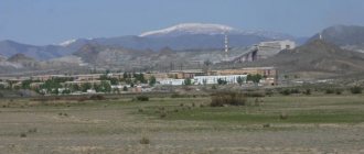
The city of Neryungri is located in Southern Yakutia and is the center of the region of the same name. National composition: Russians, Yakuts and Evenks. In 2016, 57,791 people lived there, which is quite a lot for the Republic of Sakha. The city of Neryungri is the second largest in it. It was formed on November 6, 1975, on the basis of a concentration of geological exploration parties, a settlement of miners and workers of the territorial production complex. In modern Russia, this cultural and industrial center is considered quite promising. This is largely facilitated by the fact that the federal highway Lena and the Berkakit - Tommot - Yakutsk railway pass through it.
| Population: 57,791 people. | City area: 93.00 km2 |
| Time zone:UTC +9 | Telephone code:+7 (41147) |
| Postal code:678960 | Automotive region:14 |
| Housing cost per m2: RUR 29,194. | Average salary: RUB 36,066. |
Geographical location of Neryungri
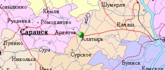
Neryungri is located in Eastern Siberia at latitude 57, seventy kilometers from the confluence of the Chulman River with the Timpton River, about eight hundred and twenty kilometers from the capital of the Sakha Republic, along the Lena Federal Highway. Neryungri - Passenger - the main railway station of the Republic.
The territory of the Neryungri district is 105 thousand square kilometers. Most of which is occupied by the Aldan Highlands.
Seismicity of the zone is 7-8 points. Up to 250 earthquakes of magnitude 1-3 occur in the area per year. This explains the high requirements for city development. It is located in the northern foothills of the Stanovoy Ridge (a large linearly elongated relief with pronounced slopes in the southern part of the Far East of the Russian Federation) with an altitude above sea level of 800 - 850 meters.
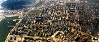
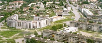
The relief of Neryungri is so rugged that one part of the city is located on the planes of the peaks, and the other on steep slopes. However, some parts of the city are located in the lowlands of the region. The old town of Neryungri, now an industrial zone, is located 6 kilometers from the center and 100 meters below the level of the new city. Also, the Neryungri-Pasazhirskaya railway station is located near the river. Ammunakta. Interesting fact: the temperature between the city center and low-lying areas can differ by 10 degrees Celsius in winter. However, the main part of the city is located on the peaks.
Neryungri on the map of Russia
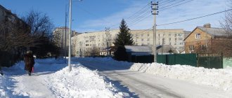
The region of Eastern Siberia, where Neryungri is located, belongs to sharply continental climatic zones. In winter, temperatures can drop to -61°C. True, this is an absolute minimum; such frosts do not happen very often. Usually the temperature is kept at 30-35 °C. In summer, the air temperature can rise to + 34 °C.
The city of Neryungri in Yakutia lies at the same latitude as Moscow and is located on the right bank of the Chulman River, in an area with a rather complex topography of the spurs of the Stanovoy Range, so the topography of the streets is also rugged, but some parts of the city are located in the lowlands that form the valleys of the Ammunakta and Chulman rivers .
The distance from Yakutsk to Neryungri along the Lena highway is 810 km.
You can get to the city not only by car or train, but also by plane. 40 km from it is Neryungri Airport, owned by FKP Airports of the North. The second name is “Chulman”, after the name of the village located 8 km from it. This is a civil airport, which was created taking into account the possibility of receiving large aircraft, such as the An-124 Ruslan or Boeing 757-200. Regular air connections are provided with Moscow, Irkutsk and Novosibirsk.
Story
From Timptonsky district to Neryungrisky district
1925, August 6 – The beginning of the zoning process in Southern Yakutia. The Presidium of the YACEC forms an independent Aldan administrative district, consisting of Aldan - Timpton, Tungiro - Olekminsky districts.
1926 - Formation of an independent Timpton ulus, the center of which was the Yakut station on AYAM.
1926, December 29 - The First Congress of the Natives of the Timpton Ulus was held, at which the Plenum of the Executive Committee of 13 people was elected: 4 Russians, 2 Yakuts, 7 Tungus. According to the All-Union Demographic Census of Yakutia in 1926, there are 360 people in the Timpton ulus: 309 of them are men and 51 women.
1927 – Organization of the Timpton-Buyaginsky (Evenki) Tribal Council at the request of the indigenous population. This clan council was subordinate to the Aldan District Executive Committee.
1927, December - the village of Nagorny becomes the center instead of the Yakut station. The route of the Amuro-Yakutsk highway under construction passed through Nagorny. As a result, Nagorny becomes the most densely populated area in Southern Yakutia. All administrative institutions and organizations are moving here. In Nagorny there is also a Soyuztrans base serving the Amuro-Yakutsk highway by road, an office of the AYAM section, a large cooperative and a number of institutions of regional importance. In the villages of Khatymy, Razdolny, Berkakit, Zolotinka and Chulman, formed during the construction of the Bolshoi Never-Aldan highway, institutes of commissioners are being created.
1930, May 5 - Timpton ulus is reorganized into a district subordinate to the Council of People's Commissars of the Yakut Autonomous Soviet Socialist Republic. Until 1941, the center of the Timpton district remained the village of Nagorny.
1932 _ – The Timpton district includes: Belletsky, Delmetsky and Algamine national councils; Chulmansky, Nagorninsky, Apsakansky, Kolbachinsky rural councils.
1938 - Apsakan and Kolbachinsky rural councils are abolished. Instead of them, Kabaktan and Nerechinsky rural councils appear.
Until 1939, the region was subordinate to the Council of Ministers of the Yakut Autonomous Soviet Socialist Republic.
1939, January 16 - The settlement of Kabaktan becomes a workers' village,
1939, April 8 - The Aldansky district is re-formed with a center in the city of Aldan, as part of the Aldansky, Tommotsky, Timptonsky and Uchursky districts.
1939, August 16 - Nagorninsky rural council is divided into Nagorninsky and Zolotinsky rural councils. The Zolotinsky Village Council included a territory with a population of 950 people, including the mines Gorbylyakh, Akurdan, Kholodnikan, Stary Nezametny, Chainyt, etc., as well as the Tokarikan collective farm.
1940, January 1 - For this period, the population of the Timpton district is 7153 people, including rural - 1628 people, urban - 5525 people, population of the regional center - 2333 people.
1941, March 7 - The settlements of Nagorny, Chulman and Nerechensky village council are classified as workers' settlements.
The Timpton district includes the following village councils: Nagorninsky (center - Nagorny village), Kabaktinsky (center - Kabaktan village), Chulmansky (center - Chulman village); rural councils: Algama center - Algama village), Belletsky (center - B Khatymy village), Delmetsky (center - Sutam village), Zolotinsky (center - Zolotinka village), Nerechinsky (center - Kabakchi Ave.).
1941, April 24 – By decree of the Presidium of the Supreme Council of the Yakut Autonomous Soviet Socialist Republic, the center of the Timpton region is moved from the village of Nagorny to the village of Chulman. This decree was confirmed by the Presidium of the Supreme Soviet of the RSFSR only on September 25, 1943.
1943 – The Belletsky Village Council is abolished with the inclusion of its territory in the Chulmansky Village Council
1947, July 11 – Based on the Decree of the Presidium of the Supreme Soviet of the RSFSR, the Aldan District is liquidated. Aldan, Timpton, Tommot and Uchur districts began to report directly to the Council of Ministers of the Yakut Autonomous Soviet Socialist Republic.
1951 - Timptonsky district consists of one district Council of Workers' Deputies and 5 Councils: the village Chulmansky and Nagorninsky, the rural Zolotinsky, the hereditary Delmetsky and the nomadic Algaminsky.
1956, May 11 – The Swan-Tiit Village Council is formed on the territory of the Timpton district with its center in the village of Swan-Tiit. The reference book on administrative-territorial division for 1956 mentions the village of Neryungra, which by this point had already existed for 2 years.
1958 – Algama, Delmet village councils and Kabaktan village council are abolished.
1960, January 1 – The Timpton district includes the Chulmansky and Nagorninsky village councils, Zolotinsky, Nerechinsky, Swan-Tiitsky village councils
1963, February 1 - Based on the Decree of the Presidium of the Supreme Council of the Yakut Autonomous Soviet Socialist Republic, the Timpton district is abolished and the territory of the district is transferred to the Aldan district.
1972, February 24 – Based on the Decree of the Presidium of the Supreme Council of the YASSR, the settlement of Neryungri was classified as a workers’ settlement. The Neryungri Village Council is formed. The Nerechinsky village council is abolished, and the settlements of Ugolny and Bolshoy Durai are subordinated to the Neryungri village council.
1975, November - Based on the Resolution of the Presidium of the Supreme Council of the YASSR, the working village of Neryungri in the Aldan region is transformed into a city of republican subordination.
1975, November 12 – Based on the Decree of the Presidium of the Supreme Council of the YASSR, the Neryungri City Council is approved with a center in the city of Neryungri, consisting of the working villages of Chulman, Nagorny, the village of Berkakit, the village of Zolotinka of the Zolotinsky village council, the village of Bolshoy Khatymy Suon - Tiitsky village council and settlements Bolshoi Durai and Ugolny of the former Neryungri village.
Historical essays
Despite the fact that the birthday of the city of Neryungri is considered to be 1975, the development of the lands of Southern Yakutia began much earlier. The first explorers of this territory are considered to be Russian explorers Vasily Poyarkov (1643) and Erofey Khabarov (1667). They began their march from Yakutsk, located on the Lena River, along the South Yakut river valleys to the Amur.
At the beginning of the 19th century, this region was actively explored by expeditions from the Russian Academy of Sciences, the Ministry of Railways and the Geographical Society. In 1891-1892, large-scale development of the area began. In those days, at the headwaters of the Timpton, Sutam and their tributaries there were approximately 80 mines, at their peak industrial. season, there were about 3.5 thousand miners. The Evenks are local indigenous people who worked as guides and transported goods. “River of Graylings” - this is how the name of the city is translated from the Evenki language.
By the middle of the 20th century, about 80 mines were already operating in the Timpton River valley, and the territory was inhabited by gold miners and local Evenki (indigenous people of the North), who were guides and workers.
Beginning in 1967, the first wooden two-story houses began to be built, sewage treatment plants, a boiler room, a hospital, a school, a car garage, a store, a canteen, a bakery, and a high-voltage power line from Pullman to Neryungri were erected.
On June 15, 1975, the Yakutuglestroy plant, at a distance of seven kilometers, began the construction of the new city of Neryungri using only its own resources. A few months later, on November 6, 1975, the city of Neryungri became a city of republican subordination.
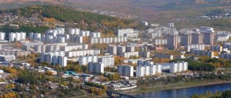
The first buildings of the new Neryungri were two-story wooden buildings. And in 1980, a house made of panels from the Neryungri Large-Panel House Construction Plant was commissioned. The first nine-story buildings were built only in 1985.
The design of the city followed the norms of the USSR, but despite this, the city has its own original design of buildings. The construction was hampered by the mountainous terrain, but thanks to this it was possible to create individual spatial solutions. The individual design of buildings in Neryungri is significantly different in its bright colored houses. Separately designed balconies and loggias add their own flavor to the city.
The All-Russian competition for the best landscaping awarded diplomas to the city of Neryungri in 1997-1999, as well as in 2002 and 2005.
Over the course of thirty years, 1,300,000 m2 were put into operation.
5 Russian cities, including Neryungri, were awarded an early loan from the International Bank for Reconstruction and Development to introduce new technologies in public utilities.
In 2007, city residents set a record - they wrote the most love letters in Russia. The letter was included in the Guinness Book of Records.
Symbols of the city
Emblem of the city of Neryungri 1985
In 1984, the coat of arms of Neryungri was established for the first time: three stylized serge on a Varangian shield - denotes Yakut hospitality, united gears - a symbol of developing industry; against the backdrop of the blue sky and green hills, a heavy-duty dump truck and a railway car filled with coal are depicted; Below is a coal seam, which is the basis for the development of the city.
The city emblem was approved on July 17, 1985.
Author of the emblem: Sergey Nefediev.
Coat of arms of the city of Neryungri and Neryungri district 2003
The updated coat of arms reflects the onomastics of Neryungri. The name of the river, in honor of which the city was named, is translated from the Evenki language as “a thousand graylings”, “a lot of fish”, “grayling” - hence the image of golden fish on a blue background, which are arranged in a ring in the shape of the sun. Three Yakut pillars are a symbol of generosity and hospitality, as well as reliability and constancy. The azure color of the background of the coat of arms denotes the beauty of nature, and also symbolizes honor, devotion, beauty, truth, and virtue.
Attractions
The peculiarity of the sights of Neryungri is that they are all either natural or modern. The buildings that were erected before 1940 have not survived. However, travelers will find something to see.
Bottle Rock
First of all, mention should be made of the Bottle Rock in the Neryungri ulus. The rock of this rock has a special structure - it resembles compressed broken glass, which was the reason for its name.
It is located 100 km from the city and belongs to the Stanovoy Range. Since ancient times, many beliefs have been associated with this rock. The simplest thing is that long contemplation of it can heal eye diseases. More romantic is that the contemplator, if he looks correctly, will see in the depths of the rock the Bird of Destiny, which will reveal to him the secrets of the universe and the purpose of his own life.
Getting to the rock is not so easy. Cars cannot drive closer than 30 km - the dense taiga begins. They make their way on foot, with great difficulty. The Evenks joke that this rock will either heal or send you to the next world. The main mineral of the rock is chrome diopside, which translated from Greek means “shape-changing stone.” And indeed, there are people who claim that they see a bird inside the rock. Maybe it's a hallucination, maybe some kind of optical effect. There is also a version that this bird is man-made and placed inside by the legendary master Soshnikov, who is the local analogue of Danila the Master or the Tula Lefty.
Timpton Cascade
The spring waters of the Timpton Cascade are also of some interest. These are more than 50 springs that flow with the purest melt water. They are located next to each other, among the stones, in the peculiar valley of the Timpton River. The water does not freeze even in the most severe frosts.
The cascade is located 55 km from the village of Chulman, the same one where the airport is located. Local historians fear that the springs could be damaged by the planned construction of the Cancun hydroelectric power station, so it wouldn’t hurt to look at them and taste the water now.
Nahot
Separately, it is worth highlighting the Nakhot thermal spring in Neryungri. As we already know, the weather here in winter is frosty. All the more admirable is the hot spring, which is located 30 km from the city and 23 from Chulman along a dirt road. A recreation center of the same name “Nakhot” was built next to it.
The temperature of the healing water is always + 32 °C, even if there is severe frost around. Once upon a time, during the years of the USSR, they planned to build a huge all-Union health resort here, but the state ceased to exist. We only managed to pave the road. And the Nahot recreation center was opened in the mid-90s by enthusiasts.
Museum of the History of the Development of South Yakutia named after. I.I. Pyankova
The most interesting museum for a traveler in Neryungri may be the Neryungri Museum of the History of the Development of South Yakutia named after. I. I. Pyankova. It was founded in 1976 on a voluntary basis. For some time it was called the “Neryungri Museum of the History of the Construction of the Small BAM and the South Yakutsk TPK,” but soon it was renamed and named after Ivan Pyankov, one of the first leaders of the city, who made a great contribution to the development of the museum.
In February 1992, a new exhibition was opened here, prepared by the museum staff together with the methodological center of the Moscow State Historical Museum. The museum's exposition presents the flora and fauna of Southern Yakutia, local minerals, information about the ancient history of the region, Russian explorers, and the material and spiritual culture of the indigenous peoples of the North. Here you can get acquainted with the geological study of the South Yakut region and the history of its industrial development, learn about the construction of the South Yakut territorial production complex, the Small BAM and the city of Neryungri itself. Address: st. Pioneernaya, building 4/1. Phones: +7 (41147) 441-82, +7 (41147) 439-33.
Actor and Puppet Theater
In Neryungri there is the only Actor and Puppet Theater in Siberia and the Far East. The history of the puppet theater began in 1985, when the Minister of Culture of the RSFSR Melentyev signed an order to create the theater “in order to further improve the aesthetic and moral education of the younger generation of Yakutia.” The birth of the theater was first welcomed by People's Artist of the USSR, Hero of Socialist Labor Sergei Vladimirovich Obraztsov.
On his recommendation, Andrei Konstantinovich Yartsev arrived from the State Central Puppet Theater and was appointed chief director of the theater. It was from this moment that work began on creating a theater team - the first actors arrived in Neryungri. The first performance was staged based on V. Korostylev’s play “What the Wizards Told About.” In 1992, the need arose to serve not only children, but also adults. On the initiative of artistic director Igor Utkin, the institution was given a new status - Actor and Puppet Theater. Address: st. Pioneernaya, house 4a. Phones: +7 (41147) 470-71, +7 (41147) 444-85.
Employment Center
It is unlikely that the employment center can be called a landmark of Neryungri, but its work should inspire respect among guests and residents of the city. The employment center is located at: Neryungri, st. Oyunskogo 1/1, phone: +7 (41147) 435-40. All those who come to this city in search of work on a rotational basis or on a permanent basis are required to visit it. Only here you can get a list of all available vacancies in the city of Neryungri in a short time. This center will tell you which company is best for you to find a job, which of them provide a social package, where they pay the most, etc.
Gornyak Stadium
On the territory of the city of Neryungri there is one of the largest sports facilities in the Far East - the indoor stadium "Gornyak". Construction of this sports facility with 3 thousand seats began in May 2006. On August 24, 2007, the opening ceremony took place. This facility became the largest of all that were built in the capital of South Yakutia in preparation for the 55th anniversary of the development of the republic’s coal deposits. In addition to the football field, the stadium has athletics tracks, a gym, and rooms for table tennis and aerobics. Address: st. Churapchinskaya, house 33.
With the opening of the Horizon ski resort in 2010, the stadium began a new chapter in sports life. The range of health services provided has expanded, and rental of downhill and cross-country skis, snowboards and tubing has been organized. In 2012, a significant event for the base was the holding of the second winter Olympics in alpine skiing and snowboarding. Since then, the Russian national biathlon team has regularly trained on the roller ski track.
In total, there are 143 sports facilities in the Neryungri district: the Shakhtar and Bogatyr sports complexes, an indoor skating rink, gyms and swimming pools, tennis courts.
The city has its own radio; two federal channels provide time for local television. Among the entertainment establishments, there is a Burger Club restaurant and the famous beer restaurant “Zastolye”. There is also a printing house where more than 10 newspapers are published, and one of them is called “Simply Nyurka”. The fact is that the residents jokingly call their city Nyurka. Local media is known not only for its paper form, but also for its online form.
So, Neryungri is far from the last place on the map of Yakutia and Russia. Despite the small number of inhabitants, this region brings many benefits, is rich in minerals and famous for its traditions. It is worth visiting first of all in order to feel the spirit and special beauty of Siberia.
Bottle Rock in Neryungri District
Bottle Rock is a mystical place about which little is known. Local residents claim that the rock can cure eye diseases. The rock got its name due to its peculiar structure: the rock resembles broken and pressed glass. If you press your face to the rock and peer for a long time into the translucent depth, your visual acuity sharpens - “you can see a bird in the sky and even its feathers.” Geologists decided to figure out what was going on and found out that the stone consists of the mineral chrome diopside, similar in composition to emerald, which, according to ancient physicians, has the ability to heal eye diseases.
Museum named after I. I. Pyankov
Any traveler should visit this historical place, dedicated to the difficult development of South Yakutia. The museum has been operating since 1976, named after Ivan Pyankov, who was one of the first leaders of the new city. He made a significant contribution to the development of the attraction.
The new exhibition appeared at the beginning of 1992. It introduces visitors to the flora and fauna of the southern part of Yakutia. Here you can come into contact with the spiritual culture of the local northern inhabitants, the ancient history of the harsh region and its first explorers, and examine the mineral resources available in the region. The exhibition also tells:
- on geological exploration of a territory little developed by man;
- industrial development;
- construction of the Small BAM;
- construction of a territorial production complex;
- creation of the city.
Future prospects for the city of Neryungri
Today, the city of Neryungri is one of the most strategically important and promising cities in Yakutia. The Federal Highway “Lena” passes through the Neryungri district, which connects the Republic of Sakha with the Far East and Russia, as well as the railway, which today has reached the village of Nizhny Bestyakh, 30 km away. from Yakutsk and will be launched in 2022.
The construction of the Power of Siberia gas pipeline is underway in the region to transfer gas from Yakutia to the Primorsky Territory. Also, the Eastern Oil Pipeline passes through the Neryungri region, which supplies oil from the fields of Eastern Siberia to the USA and Asian countries, with a length of 4,740 km.
In December 2016, an Advanced Development Territory was created in the Neryungri district on two investment sites: the Inaglinsky mining and processing complex and the Denisovsky mining and processing complex with an area of about 23.2 thousand hectares.
In 2022, a large-scale reconstruction of Chulman airport is planned with the assignment of “international” status.
Historical reference
The official formation of the city dates back to the 70s of the last century, but settlements appeared on its territory a long time ago, around 1643, with the advent of the first expeditions. An active period of development occurred in the 19th century, when mines began to appear along the river. The territories of the modern city were inhabited by Evenks, gold miners . In 1967, the following began to line up:
- two-story buildings;
- hospital with school and shop;
- treatment facilities;
- bakery and cafeteria;
- boiler room;
- high voltage line.
On November 6, 1975 (recognition and day of the city of Neryungri), construction of a metropolis began near the village of the Yakutuglestroy plant of regional significance, which subsequently came under republican subordination. It has its own time zone, index, phone number (code - 14), chapter. The first blocks were represented by houses with 2 floors. But already in 1980, the first townspeople moved into a panel residential building built from materials from the Neryungri plant. After 5 years, 9-story buildings appeared.
The modern industrial center was planned according to the standards in force in the USSR. But this fact did not prevent him from acquiring a bright personality. The mountainous landscape was an obstacle to construction work, while at the same time helping to find original solutions in architecture. This is how a settlement appeared, radically different from other northern cities. The balconies with the facades of the houses are painted with bright colors and set a unique flavor. Neryungri has repeatedly received a diploma for impeccable landscaping at the All-Russian competition.
Population
Population in Neryungri for all time
In 1959, the number of residents of the city was 500 people. In 1970 the population increased to 700 people. Until 1996, the city's population grew steadily and amounted to 76,700 people. From 1997 to the present day, the population has been declining. Over the course of 20 years, the city lost 20,000 residents. As of 2017, the city's population is 57,247 people.
National composition of the population
Russians - 92%, Sakhas - 5%, other nationalities - 3%.
The main language is Russian.
Timpton Cascade
It is one of the attractions of Neryungri, carrying clean spring waters and spewing them out with several dozen springs. The location is the Timpton River Valley. Melt water maintains above-zero temperatures all year round; ice does not form even in the most severe frosts.
The cascade is located 50 km from the village of Chulman, on whose territory the airport operates. Experts agree that the creation of the Cancun hydroelectric power station could cause irreparable damage to the natural monument.
Another place worthy of attention is the Nakhot thermal spring. Even in winter, the hot spring does not freeze and is a delight. A recreation center of the same name with comfortable rooms was built in the immediate vicinity.
The healing water maintains a temperature of +30 °C throughout the year. During the Soviet era, it was planned to create an all-Union large-scale health resort here. However, before the collapse of the state, only a road was built. The designated recreation center appeared in the 90s on the initiative of enthusiasts.
Business life
The most promising area of activity in the region today is entrepreneurship. The number of people employed in small and medium-sized businesses is approximately 8,000 people.
To support business and interaction, the following were created: Association of Young Entrepreneurs; Public Coordination Council for Entrepreneurship, District Entrepreneurship Council. These structures provide assistance and support to small and medium-sized businesses and entrepreneurship in the area.
Gornyak Stadium
This is a large-scale sports facility and the pride of Siberia. The creation of an indoor facility designed to accommodate 3 thousand people began in 2006, and a year later it was opened. The Gornyak stadium surpassed in scale all the facilities built in South Yakutia in preparation for the anniversary of the development of coal deposits in the republic. The sports complex includes:
- table tennis rooms;
- training facilities;
- athletics tracks;
- football field;
- aerobics rooms.
The stadium began its new sports page due to the opening of the Horizont ski complex. The list of health services has increased, rental points for cross-country and alpine skis, tubing, and snowboards have opened. In 2012, the second winter sports competition took place on the base’s territory. After such an event, the Russian biathlon team regularly trains on the ski slope.
The Neryungri district has more than 140 sports complexes, which include numerous tennis courts, swimming pools, gyms, indoor skating rinks, the Bogatyr and Shakhtar complexes.
The city is equipped with federal channels and radio broadcasting news. Local residents and tourists often relax in the Burger Club restaurant and the Zastolie beer pub. The local printing house regularly publishes newspapers (more than 10 titles). City media work not only with paper information, but also with electronic media.
Neryungri occupies an important place on the map of harsh Yakutia and the Russian Federation as a whole. Despite the fact that the population is small, the region bears an important cultural heritage, traditions, and is rich in minerals. Only here can a person truly experience the beauty and free spirit of Siberia.
Transport support
Today there are no problems with transport in the area. The only railway in the Amuro region, the Yakutskaya Railway, passes through Neryungri. From the city you can travel by train to Aldan, Tommot and Nizhny Bestyakh (the station was put into operation in 2022), and in the opposite direction to any corner of Russia. The travel time of the direct train Neryungri – Moscow is 5 days.
35 km. From the city there is the Chulman airport. Twice a week there are flights Neryungri - Moscow, Neryungri - Novovsibirsk, as well as flights to Yakutsk, Khabarovsk, Irkutsk and Krasnoyarsk. The airport is expected to undergo reconstruction in 2022.
Travel time to Yakutsk along the Lena highway will be approximately 12 hours. Approximately 2 times a week such flights are carried out from the city to the capital of the republic, exclusively by private cabs.
There is a daily commuter bus service between the village. Serebryany Bor, town. Chulman, village Berkakit, village Iengra.
In the city itself you can use both bus and taxi.
Bus routes: No. 3, No. 4, No. 5, No. 2, No. 12, No. 8.
Taxi companies: “Lux”, “Grand”, “Favourite”, “Indriver”, etc.
City map
Neryungri is a rather small town by Russian standards. But for a traveler who comes here for the first time, it won’t be difficult to get lost. Therefore, before visiting it, we suggest that you carefully study the map of Neryungri with streets given below.
The city is divided into 12 quarters. The central ones are blocks A, B and K. You can download a more detailed map of Neryungri with blocks here.
Education, culture, medicine, sports
Educational institutions in Neryungri:
Higher and secondary vocational education:
- Technical Institute branch of the North-Eastern Federal University named after M.K. Ammosov
- Neryungri Medical College
- South Yakutsk Technological College
- Institute of Professional Innovation
Primary and secondary education:
- 27 kindergartens
- 12 schools
- 1 lyceum
Healthcare in Neryungri:
- Neryungri City Hospital
- Clinical diagnostic laboratory
- Bacteriological laboratory
- Laboratory of Clinical Immunology and AIDS Diagnostics
- Ambulance station
- Dermatovenerological dispensary
- Tuberculosis dispensary
- children's Hospital
- Psycho-neurological clinic
Culture:
There are 4 libraries operating in the area: Neryungrinskaya, Berkakitskaya, Chulmanskaya and the Serebryany Bor village library. Three museums: Cultural-Ethnographic and Central City Museum, as well as the Museum of Construction of the South Yakut Territorial-Industrial Complex.
There are several Orthodox churches in the city.
Cultural centers include the A. S. Pushkin Center for Culture and Spirituality, which is located opposite the city administration.
Also in the city there is the only Actor and Puppet Theater in Eastern Siberia and the Far East.
The children's art school and the children's choir school “Nightingale”, located in Neryungri, are winners of awards at many festivals and competitions, both in Russia and abroad.
Gornyak Stadium - built in 2007, is the largest indoor stadium in the Far East, with a capacity of 3,000 seats. In addition to the Gornyak stadium, the city has: the Bogatyr sports complex, the Shakhtar sports complex, an indoor skating rink (in Neryungri and Serebryany Bor), the Erel wrestling school, a swimming pool, the Snowman ski base, the Atlant sports and fitness complex and many others. There are 143 sports facilities in Neryungri.
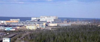
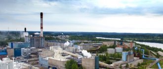
Industry
Neryungri is famous for the largest deposit of coking coal in Russia. Coal is mined here in open pits in large open pits. Coal mining is the main industry in the city of Neryungri. One of the most important enterprises of the city is the Closed Joint-Stock Company "Small Open-Gap Neryungri".
The company was founded relatively recently - in 2000. Most of the residents are employed in auxiliary production of the territorial production complex. This is a coking coal processing plant, a plant for the repair of mining equipment, and a state district power station.
administrative districts
The district includes seven municipalities, a total of nine settlements.
Municipal composition
| Cities/Cities | Population | Male | female | Populated areas in jurisdiction |
| Neryungri Urban District (Neryungri) | 61,747 | 29,674 (48.1%) | 32,073 (51.9%) |
|
| Urban settlements | Population | Male | female | Populated areas in jurisdiction |
| Berkakit Urban District (Berkakit) | 4,291 | 2,036 (47.4%) | 2.255 (52.6%) |
|
| Urban District Zolotinka (Zolotinka) | 620 | 304 (49.0%) | 316 (51.0%) |
|
| Urban district Serebryany Bor (Serebryany Bor) | 4,163 | 2,034 (48.9%) | 2,129 (51.1%) |
|
| Khan urban district (Khani) | 764 | 407 (53.3%) | 357 (46.7%) |
|
| Chulman Urban District (Chulman) | 10,077 | 4,722 (46.9%) | 5,355 (53.2%) |
|
| Rural settlements | Population | Male | female | Judicial rural settlements * |
| Iengirinsky Nasleg (Iengrinsky) | 1,104 | 516 (46.7%) | 588 (53.3%) |
|
Branch source:[10] Population source:[4] *Administrative centers shown on bold
Avenue of Friendship of Peoples
Not far from the puppet theater is the central city Lenin Square and the “Friendship of Peoples” Avenue. If you are lucky enough to visit on New Year's Eve, then you will be attracted here by the twinkling lights of the city beauty Yolka and the shine of ice sculptures. A few weeks before the beginning of December, huge blocks of ice are brought to the city square. And right there in the central square, skilled craftsmen bring fairy-tale characters to life. At night, most of the sculptures are additionally illuminated. Every year the masters surprise with new characters from the purest ice.
Forged figures with color installations excite the imagination.
Winter's Tale next to the Actor and Puppet Theater.
And for those who decide to remember their childhood, there is the opportunity to slide down a real ice slide.
Traditionally, local children gather around a carved slide made of pure ice, competing to see who can go the farthest.
Chiryaev City Park
Be sure to visit the city park named after Gabriel Iosifovich Chiryaev and take a walk among the huge trees; in summer and winter it has its own atmosphere. When you go to the park, take with you a treat for its inhabitants.
These unusual dark brown squirrels live in a city park in Neryungri.
Squirrels are completely tame, and it’s easy to take a couple of photos with them.
There are feeders for squirrels, and the black-brown beauties themselves are not afraid of vacationers. On the contrary, they quickly descend from the centuries-old pines for a treat.
Therefore, if you want to take a couple of positive photos and get a lot of positive emotions, a walk in a city park is “just what the doctor ordered.”
Also, in the center of the park there is a Memorial of Glory. It was opened in 2005, in honor of the 60th anniversary of Victory in the Great Patriotic War. The memorial is simply huge; it consists of a bowl with the Eternal Flame and a statue of the Goddess of Victory - Nike, towering on top of a concrete pedestal. Nika’s height is 7 meters, and the goddess holds a laurel wreath in her hands.
Memorial of Glory.