During any travel around the world, be it a business trip or a tourist voyage, a map is an indispensable assistant.
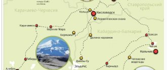
If you need to go to the mountains of the North Caucasus, then a satellite map of Kabardino-Balkaria will serve you well: it will not let you get lost in an unfamiliar area.
You can easily find any areas, cities, natural sites, attractions, tourist centers of the republic on the road map of Kabardino-Balkaria, where all the main objects are marked in detail.
Tourism as a brand of the Kabardino-Balkarian Republic
After the collapse of the USSR, our country Russia abruptly changed course and switched to a market economy. The years of perestroika were a big shock for the economy, production became unprofitable, old ties between enterprises were broken, imports took over the market. For such Republics as Kabardino-Balkaria, the main task for survival was the struggle for market. Today it is clearly visible that tourism can become one of the levers in the struggle for the market. In Kabardino-Balkaria there are more than thirty thousand beds (resorts, hotels, boarding houses and children's camps) that can provide more than 20% of the budget and occupy more than 10% of the working population. It is difficult to calculate the dividends received from the growth of the brand of Kabardino-Balkaria as a tourist republic, with its developed infrastructure and skillfully providing this service. It is impossible not to note that a good name, that is, a brand, will lead to an increase in sales in the field of agricultural production and intellectual property, which will significantly strengthen the economy of the republic and lead to general prosperity. By developing this type of business as tourism, we will receive highly qualified specialists in demand in labor exchanges in Russia, which will also lead to selection and strengthening of ties, so necessary for coexistence in the modern world. From year to year, the leadership of the Kabardino-Balkarian Republic skillfully leads the fight for the tourist flow, where the prerogative of the republic’s leadership is to conclude contracts with transport and logistics companies to buy tickets at preferential prices in advance, so necessary in the competitive struggle. The creation of a tourist bus fleet will become one of the key tools in the tourism business. The release of a single voucher, which includes transfer, accommodation, food, medical and recreational part, will become a product that will be the hallmark of our Republic. One of the final steps would be the opening of representative offices in large cities of Russia to present the tourism product. It would be rational to attract students studying in these cities from our republic to these representative offices, which would help partially solve the return and employment of our youth. TO BE CONTINUED…………
What to see if you come to Nalchik with a child
The most striking attractions for children are perhaps the following:
- Puppet Theatre;
- fountain "Elephants";
- entertainment town "Treasure Island".
Puppet theater in Nalchik
The Kabardino-Balkarian Republican Puppet Theater was created in 1986. Its first actors were such famous artists as Panina, Tehazhev and Kumykova, and the play was the production “My Friend is the Sun”. Subsequent works brought creative success to the theater, for example, “The Good Lion” (the performance was performed in Russian and Kabardian languages).
Now a child may be interested in the works of modern directors:
- “Tricks of a Cunning Parrot” by S. Belov, I. Shamrova;
- “The Pipe of Ashamaza” by S. Zhiletezhev (based on the Nart epic);
- “Golden Chicken” by V. Orlov;
- “White Rose” by B. Junger;
- “The Best Carrot” by K. Abramtsev, etc.
The theater has been repeatedly awarded with certificates from the Ministry of Culture of the Kabardino-Balkaria, and has more than once been awarded the prize of the Union of Theater Workers of the Kabardino-Balkaria in various categories
. The Puppet Theater is located on Keshokova Street, 60. A ticket to the performance costs 70 rubles.
Table: theater operating schedule
| Day of the week | Operating mode | Lunch break |
| Monday | From 9:00 to 18:00 | From 13:00 to 14:00 |
| Tuesday | ||
| Wednesday | ||
| Thursday | ||
| Friday | ||
| Saturday | Weekend | — |
| Sunday | — |
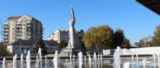
Fountain "Elephants"
A fountain with elephants appeared in Nalchik in 2010. The composition is made in oriental style. The bowl of the pool itself has an octagonal shape, and a rotunda is installed on the backs of four elephants. Jets of water flow from the trunks and fall into the center of the bowl.
The sides of the pool bowl and the dome of the rotunda are covered with oriental patterns and ornaments - this cannot leave any passerby indifferent
The famous fountain is located on one of the walking alleys of the Atazhukinsky Garden. You can get to it by almost any minibus (stop “Kindergartens”).
Nalchik Zoo
The Nalchik Zoo was founded in 1927 at the Lenin educational campus. Initially, this object should become something like a manual for studying natural science. And when the territory of the zoo was inhabited by exotic animals, all the townspeople became interested in it. The total area of the facility is about 7 hectares. There is a special children's playground with free entry.
Currently, zoo guests can watch 350 animals (150 species), including:
- brown and black bears;
- macaques, hamadryas, marmosets;
- birds (parrots, finches, pigeons, peacocks, etc.);
- aquarium fish;
- lions, tigers, puma, leopards, etc.
Photo gallery: inhabitants of the Nalchik Zoo
The zoo is located at Dolinsky Lane. It is open daily from 9.00 to 18.00, ticket prices start from 60 rubles.
"Treasure Island"
"Treasure Island" is a children's entertainment center, which is a play town. The following services can provide entertainment for your child:
- work of animators;
- cafe with children's menu;
- safe trampoline attractions;
- dry pools with plastic filling;
- slides, mazes, etc.
Photo gallery: Treasure Island play areas
The play town is located in the Deya shopping center (Kirova Street, 30). It is open every day from 10.00 to 22.00, tickets cost from 150 to 200 rubles.
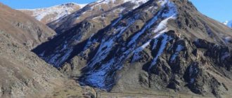
Adyr-Su Gorge
A picturesque place located on the territory of the Elbrus National Park. At the beginning of the gorge you can admire the mesmerizing waterfall, which is formed by the stormy waters of the Adyr-Su River. There are many mountain peaks here (Dzhailyk, Sullukol, Tyutyu-bashi, Kayarta, Sakashil, Killar and others), to which routes of varying difficulty levels have been laid.
In Adyr-Su, the reserve regime is observed, there are few casual visitors and tourists. Aurochs live in these places, and bears live in the berry patches and thickets of undergrowth. Among the screes and rock walls live mountain turkeys - snowcocks. However, this bird is rarely seen, but often in the silence of the mountains you can hear its melodic singing.
The lowlands of the gorge are covered with forests, but with height they thin out, giving way to alpine meadows, and behind them are snowy peaks, inaccessible cliffs, and glaciers.
Elbrus and Elbrus region
Among tourists who come to the republic in order to improve their health, play sports and capture natural beauty as a souvenir, the Elbrus region is most famous. A detailed road map of Kabardino-Balkaria will tell you how to get there in the most convenient way.
The district adjoins the Zolsky and Baksansky districts, and its administrative center is the city of Tyrnauz. This city is a real attraction in itself. Built in Soviet times to mine and process tungsten discovered in Kabardino-Balkaria, today it is slowly dying out as the plant has long been abandoned. A schematic map of Kabardino-Balkaria will indicate the exact location of Tyrnauz high in the mountains. Everyone who travels to Elbrus crosses the city.
The Elbrus region includes a large number of industrial enterprises. The ethnic composition of the population is mainly Balkars. Here, in the Elbrus region, the flow of tourists who want to climb Elbrus does not dry out. In winter there are ski slopes and in summer there is a ski lift. The government of the republic plans to eventually turn Tyrnauz into a tourist center and thereby save the city from destruction.
The Elbrus region is famous as a balneoclimatic zone of the republic, where resorts are located. Most of this territory is included in the Elbrus region national park, protected by the state.
Kabardino-Balkaria has enormous recreational (i.e., used for health and recreation) resources. There are many unique natural attractions here. You can come here either on a tourist package or on your own, only in the second case you must stock up on a detailed map.
What sights to see in the vicinity of Nalchik
In the surrounding area from Nalchik there are also many interesting places that tourists should definitely visit. For lovers of active recreation, the mountains of Bolshaya and Malaya Kizilovka will be an excellent pastime. The mountains are especially attractive in autumn.
Mount Bolshaya Kizilovka is a flat mountain in the vicinity of the city of Nalchik, from the top of which a magnificent view of the surrounding nature opens.
The excursion is worth visiting for the stunning views and wide range of flora. Some tourists prefer to stay here with tents for the night.
There are a large number of luxurious monuments on the territory. The establishment is located near the city, so tourists can also visit other interesting places. Additionally, you will be able to improve your health and gain strength and energy.
For complete recovery of the body and drinking mineral water, it is recommended to visit the Water and Mud Bath.
The staff carefully approaches all guests and selects an individual complex. It is guaranteed to have a positive effect on the human body. He will return to his hometown several years younger.
Where is it, how to get there
Prokhladny in Kabardino-Balkaria is the administrative center of the Prokhladnensky region and is considered a settlement of republican subordination. It is listed as an urban district of the municipality and is the only settlement included in its composition.
Prokhladny ranks 2nd in terms of the number of residents among the cities of Kabardino-Balkaria. According to the latest population census, in 2019, the number of residents was almost 58 thousand people. The residential density in Prokhladny is 1,650.03 people per square meter. km. The total area of the city is 35.08 square meters. km.
Prokhladny is a cosmopolitan city, home to:
- Russians;
- Turks;
- Armenians;
- Germans;
- Koreans;
- Kabardians;
- gypsies;
- Ukrainians.
Due to the multinational composition of the population, several religious denominations have been formed here:
- Orthodox;
- Catholics;
- Sunni Muslims;
- Adventists;
- Baptists;
- apostolic Christians.
Geographic coordinates of the city: 43°45′26″ N. w. and 44°01′46″ E. d, the height of its center above ocean level is 208 m. The city is located in the northeast of the region, on the left bank of the Malka River and is located 50 km from the northeast side of the city called Nalchik. The length of the city from east to west is 11 km, from north to south – 4 km.
The main territory of the city is a forest-steppe zone with a relatively flat surface. The hills in some places rise to a height of 214 km above sea level. The Baksan River flows into a river called Malka, in the southeast of the republic. Downstream the Malki River, it flows into the Terek.
On the southern side of the city there are several deep lakes, the largest of which is called Komsomolskoye. On the northern side of the city is the Bolshoi Prokhladnensky Canal. There are various ways to get to the city.
By plane
The city does not have its own airport.
The city of Prokhladny, Kabardino-Balkaria, does not have its own airport. You need to get to Nalchik by plane.
The nearest airports that you can fly to and then get to Prokhladny by car or bus are:
| airport | distance to Prokhladny, km |
| Nalchik | 42 |
| Mozdok | 44 |
| Beslan | 75 |
| Magas | 91 |
| Mineral water | 94 |
Prokhladny (Kabardino-Balkaria) is an important railway and road junction.
By train
At the address: Prokhladny city, st. Vokzalnaya, house No. 1, there is a railway station called “Cool”. It is located at a distance of 2.4 km from the city center. At a distance of 15.1 km from the center of Prokhladny, at the address: Maysky city, st. Zheleznodorozhnaya, house No. 120, is the Maysky railway station.
By bus
There is a large bus station in the city of Prokhladny. It is located 1.6 km from the city center at the address: Prokhladny, st. Gagarina, house No. 38. At a distance of 15.1 km from the center of Prokhladny, the Maysky bus station is located. Its location: Maysky city, st. named after May 9, house No. 162.
Administrative division
Kabardino-Balkaria appeared on the map of Russia in 1921 as an autonomous region, becoming a republic only in 1992. The capital of the republic is the resort city of Nalchik.
According to the administrative and legal structure, it is divided into 3 urban districts and 10 districts with rural settlements and towns:
| Municipality | Name | Settlements of the municipality |
| Urban district | Nalchik | 1) City of Nalchik; 2) 8 villages. |
| Baksan | 1) Baksan city; 2) the village of Dugulubgey. | |
| Chill | Prokhladny city | |
| Area | Elbrus | 1) the city of Tyrnyauz; 2) 6 settlements. |
| May | 1) City of May; 2) 4 settlements. | |
| Tersky | 1) Terek city; 2) 17 settlements. | |
| Prokhladnensky | 1) Prokhladny city; 2) 19 settlements. | |
| Chereksky | 1) Kashkhatau town; 2) 9 settlements. | |
| Baksansky | 1) Baksan city; 2) 13 settlements. | |
| Urvansky | 1) The city of Nartkala; 2) 11 settlements. | |
| Zolsky | 1) Urban settlement Zalukokoazhe; 2) 15 settlements. | |
| Chegemsky | 1) City of Chegem; 2) 9 settlements. | |
| Leskensky | 9 settlements. |
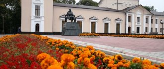
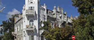
Restaurant "Sosruko"
“Sosruko” is a famous Nalchik restaurant dating back to Soviet times. It is located on Mount Kizilovka and is clearly visible from almost all corners of the city. The restaurant's structure represents the head of the hero Sosruko with an outstretched arm holding a torch. According to legend, it was Sosruko who brought fire to the heroes who lived on this mountain.
The building was built in the middle of the last century and has received various prizes and awards many times. After major renovations in 2004, a beautiful waterfall was installed next to the restaurant, above which statues of birds rise, and makhsyma, the national low-alcohol drink of the residents of Kabardino-Balkaria, flows from the tap of the waterfall into a bowl. The restaurant has a very warm and cozy atmosphere, and the menu here consists of national dishes.
Location: Lermontov street - 25.
Cultural and historical recreation
Kabardino-Balkaria on the map of Russia looks like a large cluster of mountain ranges and massifs, which occupy more than 60% of the republic’s area. The most beautiful sights of the region are located in the mountains and foothills. But, in addition to natural beauties, there are many cultural and historical attractions, mostly concentrated in Nalchik.
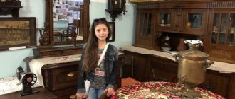
- The National Museum of the Republic of Kabardino-Balkaria is located in the capital of the region (on Gorky Street) and consists of 10 halls. The entire local history collection of the republic is collected here, including natural, archaeological and ethnographic exhibits. Lectures are often held on the territory of the museum, there is a history club and a library.
- Restaurant Sosruko - one of the most recognizable architectural structures of the mid-20th century, depicted on many souvenirs and advertising brochures. The unusual building is made in the shape of the head of the hero of local legends - Sosruko. A helmet is placed on the head, and next to it is the hand of a hero holding a fiery torch. The restaurant is located in Nalchik, on Mount Bolshaya Kizilovka, at 640 meters above sea level. You can climb the mountain using a cable car. The helmet's observation deck offers a beautiful panoramic view of the surrounding area. The restaurant itself is not open, but the observation deck is open to the public.
- The City of the Dead is a cultural and historical monument near the village of El-Tyuby in the Chegem region. It is an open-air museum of burial structures. The earliest burials date back to the 10th century. Previously, it was believed that the sacred element of the earth should not be desecrated by the bodies of the dead, therefore, for their repose, special houses of the dead, keshenes, were built, which were like family crypts. The City of the Dead is included in the list of anomalous zones in our country, since at the end of the 20th century. Mysterious flashes of unknown origin were observed here.
- Arch of Friendship - is called “Forever with Russia” and was installed at the entrance to Nalchik in 2007. The memorial complex is made in a conservative style and is dedicated to the reunification of Kabarda and Balkaria with Russia. It has become one of the city's most recognizable landmarks.
- The Mountaineering and Hunting Museum of V. Vysotsky is actually of a local history and educational nature and includes hunting trophies, equipment of climbers from different years, information about the first conquerors of the peaks. The central place of the collection is given to materials related to the film “Vertical”, in which Vysotsky played the main role. The museum contains his personal belongings, songs and records, a gun and a tent from the filming. The museum is located in the Tyrnyauz region of the Elbrus region, in the village of Tegenekli, where in the middle of the 20th century. The film was being filmed. The unique building is built from volcanic rocks.
Cities and villages
Nalchik
Nalchik is a republican center. The founding date of the city is considered to be 1822. Previously, in its place there was an aul of Toghlats, which grew by the beginning of the 19th century. to the administrative center of Kabarda. It was the residence of the Kabardian princes. For the defense of Nalchik, a fortress was built, the defenders of which were Russian soldiers.
Today Nalchik is the industrial, cultural and educational center of the republic.
Guests of the city can visit:
- Balneological and mountain climatic resort. Built on the outskirts of the city, next to the Belorechensky mineral springs. Silt mud from Lake Tambukan is also used for treatment.
- Nalchik city park. It contains rare plant species. There are tourist routes by cable car over artificially created reservoirs.
- Bolshaya Kizilovka is a 750 m high mountain with an equipped observation deck. There are walking healing routes there.
- House-museum of Marko Vovchok. The writer lived the last years of her life in this small house. The exhibition introduces the life and work of the Russian-Ukrainian writer.
- State United Museum of the Kabardino-Balkarian Republic. Introduces interesting pages of history, culture and traditions of the peoples inhabiting Kabardino-Balkaria. A large collection of national clothing and household items of the indigenous peoples of the republic is presented.
- Kabardino-Balkarian Museum of Fine Arts named after A. L. Tkachenko. A large collection of paintings, engravings, porcelain, watches, and clothing is presented. The museum has a large collection of works by Russian, Western and local artists.
Terskol village
Until the middle of the 20th century. on the site of the village of Terskol there was the Kochkarovsky farm - the ancestral village of the Balkars. In 1944, the inhabitants of the village were deported. People were able to return home in 1957. Today Balkars make up about 75% of the village's population. Terskol developed exclusively as a tourist center to serve vacationers in the Elbrus region. Terskol is one of the largest ski resorts in Russia. In addition to sports, you can watch:
- The monument to reporters and correspondents who died in the Caucasus was erected in memory of the tragic events of 1944.
- Military burial place of the fallen Soviet soldiers who fell in battle with the Edelweiss mountain division in September 1942.
- Museum of the Defense of the Elbrus Region - collected exhibits (photos, military maps, personal belongings) telling about the feat of Soviet soldiers who defended the Elbrus region during the Second World War.
In the village of Terskol, routes to natural attractions located in the area begin: the Maiden Spit waterfall, the Narzanov glade, the Adyr-Su gorge, the Djily Su tract, the Azau waterfall.
Chill
The city of Prokhladny is the second most populous city in Kabardino-Balkaria. There is a legend according to which the city owes its name to the governor of these places, P. Potemkin. Allegedly, in the summer he passed by the Malka River and stopped to rest in a small settlement. This place abounded in plants. The governor had a pleasant time in the shade of the trees and the coolness of the river and called this settlement Cool.
The history of the settlement began in 1765. Prokhladny was originally a Cossack village through which the postal route passed. He connected Transcaucasia with Russia. Today the city is a transport hub and a republican industrial center.
In the city you can see:
- Cathedral of St. Nicholas the Wonderworker. Built in the shape of a cross in 1886 on the site of a burnt wooden church. The decision on construction was made by all residents of Prokhladny at a general meeting.
- Memorial House-Museum of K. Sh. Kuliev. The exhibits tell about the life of the Balkar poet.
- Museum of History and Local Lore. Exhibits related to the history of the settlement from its formation to the present day have been collected. The collected materials tell about the fates of famous fellow countrymen: Admiral A. G. Golovko, heroes of the Soviet Union G. D. Voronchenko and N. M. Didenko and others.
Brief description of Nalchik
Nalchik is a small cosmopolitan city in the southern part of Russia. It is the capital of the Kabardino-Balkarian Republic and bears the title of “City of Military Glory”. The mountains, like a horseshoe, encircle Nalchik on three sides. To the north is the Kabardian Plain, however, it also has an undulating topography.
Nalchik is located in the northern part of Kabardino-Balkaria, which borders the Stavropol Territory and North Ossetia
The average height of Nalchik above sea level is 512 meters, and its total area is 67 km2. About 240 thousand people live in the city, most of whom are Kabardians, Russians and Balkars.
Most of the nationalities living in Nalchik speak Russian and Turkic languages, so you can understand almost any person. I know Turkish and Tatar, but I also managed to communicate with Balkars. The most difficult and incomprehensible language for Russian is Kabardian. But, as a rule, Kabardians speak Russian well too
This is especially important in villages adjacent to the city (Muslim people live in many villages)
City `s history
Fort Nalchik was built by General Ermolov (in different sources this event dates back to 1724–1822). For several years, the fortress grew into a military settlement, and by 1871 more than 3 thousand people were already living in the settlement. By the beginning of the 20th century, the local population increased to 5 thousand. Nalchik received city status only in 1921.
In 1942–1943, the Nalchik-Ordzhonikidze operation took place, during which most of the city was destroyed. The residents of Nalya are true patriots, so they began to restore it during the war. But in 1944, the forced deportation of Balkars began. They were deported into lifelong exile to Kazakhstan and Kyrgyzstan. The situation improved a little only in the 60s.
The Caucasian people are famous for their hot character and fortitude, which is why various skirmishes and conflicts often occur. So, in 1968, mass riots began (allegedly due to the murder of a hooligan by police officers). An angry crowd besieged the stronghold all day, resulting in the death of a local police officer. Calls to calm down were in vain, so law enforcement officers had to take emergency measures. Almost 30 people were convicted, three of them to death.
In subsequent years, the life of the city was more than once overshadowed by economic problems, “holes” in the budget and coups. Troubles were also caused by natural disasters. Due to its close location to the mountains, earthquakes and mudflows occurred (and still occur) in Nalchik. In the early 90s, when the entire country was suffering economic decline, the capital of Kabardino-Balkaria also suffered from the presence of refugees from other republics.
During the Great Patriotic War, some battles took place directly on the territory of the city
The situation stabilized by the end of the 90s. The city authorities did everything possible to restore and improve the city. About 10 years ago I was lucky enough to meet a young Nalchik architect. He told me that during these years, landscaping was a priority in the development strategy of the urban district. And one of the important points in the construction of new houses was the creation of special earthquake-resistant pillows - foundations that are practically indestructible by any tremors.
In 1999, Nalchik was recognized as a resort city.
Holidays in the region
Kabardino-Balkaria occupies a fairly small area on the map, but at the same time it is one of the most favorable regions of Russia for recreation and tourism.
In the foothills of Balkaria there are cold and hot mineral springs. Thanks to the healing properties of water and mud, many tourists come here every year. The resort business is well developed in the republic, and all kinds of boarding houses and health centers are ready to offer their services.
The region is a leading center for skiing and mountaineering. The number of people wishing to conquer the heights of Elbrus and other five-thousand-meter mountains (with peaks above 5 thousand meters above sea level) is constantly growing. Kabardino-Balkaria offers sports recreation for both professionals and amateurs.
The most popular routes are the Elbrus and Cheget mountains, which are part of the Elbrus region. The ski slopes on Cheget are some of the most difficult to navigate, and avalanches occur quite often.
For the convenience of vacationers, there are cable cars and ski lifts with breathtaking views of wildlife. You can get the necessary sports equipment and equipment, as well as use the services of an instructor, at one of the many tourist centers.
Downhill trails are leveled and rolled using special equipment, and for extreme sports enthusiasts there are undeveloped slopes. It is here that one of the most spectacular annual events of the republic is held - freeride competitions.
In addition to sports recreation, excursion tours to mountain gorges, protected forests, waterfalls and lakes are popular among tourists. Mountain caves are also interesting, many of which have not yet been explored. In some of them you can find underground lakes, stalactites and traces of ancient people.
In the foothills of Kabardino-Balkaria, winters are milder than in the flat areas, and summers are moderately comfortable. Snow and glaciers on the mountain tops do not melt even in summer, while in the steppes it is hot and dry.
The summer ski season lasts until about mid-July, and sometimes longer. Therefore, tourists can be found here at any time of the year. Although a summer vacation will cost an order of magnitude cheaper than the winter tourist season.
Historical places
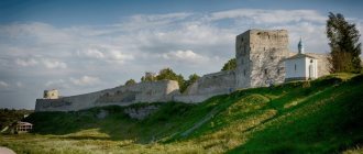
Archaeological and tourist complex "Upper Balkaria"
Address: A-154, Upper Balkaria, Upper Balkaria villageCoordinates: 43.125294,43.431015
On the territory of the archaeological and tourist complex there are numerous cultural heritage sites of Kabardino-Balkaria from the Middle Ages. In addition, this place attracts with wonderful views, clean mountain air, the opportunity to be in silence and admire the flight of eagles.
You need to spend a whole day exploring watchtowers and battle towers, feudal residences, underground and above-ground mausoleums.
Fierce battles with Mongol hordes were once fought on the territory of Upper Balkaria. Silent witnesses of those events are the fortifications of Malkar-kala, Zylgy-kala, Bolat-kala, Karcha-kala, and Kurnayat-bashi castle. For history buffs, the ruins of ancient Balkar villages are of interest.
City of dead
Address: s. El Tubu
Near the village of El-Tyuby there is a mysterious Town of the Dead. In it in the 10th-12th centuries. tetrahedral houses were built. Crypts and round mausoleums for burials of the nobility appeared in Balkaria in the 17th and 18th centuries. The burial grounds were built at different times and differ from each other in form and method of construction.
There are several versions of the construction of burial grounds. Some scientists argue that burial grounds were built because it was impossible to bury the dead in the ground due to the terrain. However, there is another version, according to which at that time followers of Zoroastrianism lived in the vicinity of El-Tyuby. According to this religion, it was forbidden to bury the dead in the ground. This was considered an act that desecrated the elements of earth and fire.
Tourists are attracted here by rumors that there is a place of power in the City of the Dead. This is confirmed by numerous legends about giant human skeletons allegedly found here. However, what is a fact is that there are a large number of centenarians in these places. But this is most likely explained by the excellent ecology.
Watchtowers in the village of Kunnyum
Address: Kunnyum village
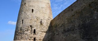
Not far from the village there are high stone towers. As a rule, the tower is named after the family to which it belonged - the Tubaev tower, the Akirov tower.
Watchtowers were erected next to the main dwelling. In case of danger, it was quickly evacuated. The buildings are about 300 years old.
Five-story towers were built. Supplies of provisions and water were raised into the twenty-meter building in case of a long siege. The whole family took refuge from enemies on the lower floors. The upper floors were occupied by soldiers. They watched through the loopholes as the enemies approached.
Monument to the “Heroes of the Elbrus Defense”
Address: Elbrus district, Terskol village
The monument was erected in honor of those who died in the Elbrus region during the Great Patriotic War. It was installed on the slope of Mount Elbrus in 1987.
Memorial complex “100 steps to Kaisyn”
Address: s. El tube
The complex was built with donations from ordinary people, admirers of the talent of the Balkar Soviet poet Kaisyn Kuliev. Lines from his works are carved on the monument.
Castle Chateau-Erquin
Route from Nalchik: along the P-288 highway to the village. Chernaya Rechka (about 20 km) Opening hours: 10.00-22.00, Tue-Sun, Mon – closed Telephone
An atypical castle for Kabardino-Balkaria, it looks like it came straight out of a postcard with views of Europe. It is built in the middle of a pond and surrounded by vineyards. The castle can be approached via an elegant bridge. Walking around the castle, which looks like an ancient fortress, you can watch peacocks, pheasants or see deer. Swans swim and fish splash in the lake.
The elite winery "Chateau Erken", created by Tembulat Erkenov, still produces the best varieties of wine in the republic. There is a tasting room in the castle.
If you have not yet chosen where you will live and want to save money when booking, we recommend using the RoomGuru service. Firstly, it contains hotels, apartments and guest houses from many different booking systems, so you won’t miss out on a worthwhile option. Secondly, you can immediately compare prices for one place in different services and book where it is cheaper (this is not always Booking!).
Sights of Kabardino-Balkaria
Kabardino-Balkaria is that part of Russia in which a great variety of natural beauties, historical monuments and unique places are concentrated in a relatively small area. It is impossible to see all its sights in one visit to the republic, but there is always something to return for.
Elbrus region and Elbrus
This two-headed extinct volcano with a height of 5642 m is visible from almost anywhere in Kabardino-Balkaria. The highest mountain in Russia is a place of constant pilgrimage for climbers. The ascent to Elbrus is most often done along the southern slope - there is all the necessary infrastructure, a shelter for those who are going to the top, and a transshipment base.
Not only lovers of high-altitude climbing come to the foot of Elbrus, but also ordinary tourists. Here they can rise to a height of 3750 m on a lift and look at the Elbrus region from above. You can improve your health in the famous Narzan Valley, where several springs with mineral water flow at once. Local residents often lead excursions to the surrounding area, for example, to the beautiful waterfalls on the Khasaut and Musht rivers. At the foot of the mountain there are several hotels and camp sites, so there will be no problems with accommodation. The Baksan Gorge, from which the path to Elbrus begins, is in itself a landmark of Kabardino-Balkaria due to its beauty and the stormy waters of the Baksan River.
Mount Cheget
Another famous peak of the republic and a favorite place to visit for ski lovers. Cheget is located next to Elbrus, as if in the shadow of a huge neighbor, having a height of 3769 meters. Several lines of cable car have been built on the mountain, which takes skiers and snowboarders to the beginning of slopes of varying difficulty.
At the foot of the mountain there is Chegetskaya Polyana, which in recent years has become a comfortable tourist village with hotels, restaurants, rentals and other necessary infrastructure. We can’t help but mention the legendary cafe “Ai”, which for many decades has been allowing tourists to dine on the mountainside in a large, bright room with incredible views of the surrounding mountains. Adding to the atmosphere is the fact that Yuri Vizbor loved to visit this cafe.
Chegem waterfalls
Among the attractions of Kabardino-Balkaria, numerous waterfalls occupy one of the key places. Chegem waterfalls, which are located 55 km from Nalchik in the picturesque Chegem gorge, are considered a real pearl of the republic. A group of three waterfalls are located in a gorge several kilometers from each other on different mountain rivers. The first waterfall is called Adai-Su (which translates as “Maiden’s Braid”), the second is a waterfall on the Sakal-Tup River and the third is the Main Chegem Waterfall. Water falls from steep cliffs in a narrow gorge surrounded by lush green vegetation, and due to the fall from a great height, water dust is formed, which allows the rainbow to appear. This whole picture fascinates with its beauty and attracts dozens of excursion groups here every day.
Cherek Gorge
There are several arguments for visiting this gorge in the Chereksky region of the republic.
Firstly, this is a historically important place: it is believed that this is where the Balkars originally settled. There are several monuments of ancient history in the gorge, for example, Amirkhan Tower, Zylgi Fortress, Kurnoyat Castle, City of the Dead
Later, a caravan route passed here; the road was so narrow that only one person holding a horse by the bridle could pass along it. This road, somewhat widened, is used to guide tourists. A narrow path among steep cliffs and with a river at the bottom of the gorge makes an indelible impression that will last a lifetime. The famous and unique Blue Lakes for the Caucasus are also located here.
Nalchik Central Park
The Atazhukinsky Garden is the heart of the capital of Kabardino-Balkaria and a source of pride for the entire republic. The history of the garden, which the townspeople call Central Park, began in 1847, when Prince Atazhukin brought seedlings of various fruit trees from Georgia and Crimea and planted them on his lands. Nowadays, there is everything for a wonderful walk: wide shady alleys, several swimming pools, numerous monuments and obelisks dedicated to the heroes of Kabardino-Balkaria. The Palace of Celebrations was also built on the territory of the park. A visit to Nalchik should certainly include a tour of the Atazhukinsky Garden.
What to bring as souvenirs
As a gift from Kabardino-Balkaria, both a bottle of healing water from mineral springs, which has a limited shelf life, and souvenir attributes symbolizing the Caucasus are suitable:
- Magnets, mugs, T-shirts, figurines with landscapes of mountains and lakes.
- Items made of natural sheep wool with traditional deer patterns.
- Wool carpets.
- Attributes of the life of the mountaineers - hats, daggers, horn cups.
- Details and decorations of national clothing created by the hands of local artisans.
- Wall horns of artiodactyl wild animals.
- Dishes made of black clay.
- A doll in national dress.
- Paintings by local artists with landscapes of Kabardino-Balkaria.
- Interior decorations made of felt, reeds and leather.
- Local cognac in crystal horns and daggers, which can only be bought at the market (officially discontinued).
It is not for nothing that Kabardino-Balkaria is considered the pearl of Russia. Despite such a small size on the map, in comparison with other regions, the republic is distinguished by its amazing natural beauty, variety of attractions and types of tourism.
The abundance of healing mineral springs located in ecologically clean areas makes it one of the most popular resort areas in the country.
Author: Anna Lalochkina
Article design: Vladimir the Great
Memorial complexes and memorable places of the city
The city has a wide range of memorial sites related to the history of the Great Patriotic War.
Within the city there is a monument to collective farmers who died on the battlefields. Next to it is the grave of unknown soldiers, cadets of the Poltava Tank School who defended the city in 1942. Here on the memorial plaque is immortalized a list of citizen soldiers who did not return from the war.
On Svoboda Street there is a Memory Square with a bust of Rear Admiral Arseny Golovko, commander of the Northern Sea Fleet. A city street is named after him.
In the central part of the city in the Factory Park there is a memorial complex with an eternal flame to the soldiers of the Soviet Army, commanders and cadets of the Poltava Tank School, residents of the city who died during its defense in 1942. Here is the largest mass grave of city residents and soldiers who died during the Nazi occupation of the city (there are about 960 bodies in the grave). In the factory park there is a monument to a soldier and a worker, which symbolizes the union of the rear and the front. The monument was opened in 1968. There is also a memorial sign to the Terek Cossacks who defended the city and died during the Patriotic War.
In 1997, a monument was unveiled to immortalize the dead Kolyonnaya townspeople in the Afghan War.
In 1998, a monument to the liquidators of the Chernobyl nuclear power plant accident was erected in the park.
On the territory of the motor transport enterprise there is a monument to the “Soldier Drivers” who died during the Patriotic War.
Near the House of Culture of Railway Workers in 1977 there is a monument to teenagers who took part in the fight against the German occupiers.
At the entrance to the city there is a monument to the soldiers of the Soviet Army who died in battle during the liberation of the city.
During the occupation, there was a concentration camp on the territory of the Food Processing Plant, in which 1,976 people died at the hands of the Nazis. In memory of them, an obelisk was erected in 1947.
Near the village of Vinsovkhoz, an unusual monument in the form of an arch with a bell was erected in memory of the city residents shot by the German invaders.
Cathedrals and churches of Nalchik
The population of Nalchik, which numbers more than 240 thousand people, is multinational. Representatives of all major world religions live in the city. They have the opportunity to participate in traditional rituals within the walls of their confessional churches, as in Kazan or, say, Makhachkala.
Mariinsky Cathedral
The majestic cathedral, which took 12 years to build and was consecrated in 2016 in the name of Mary Magdalene, became the largest temple in the republic. Up to 1000 parishioners can be accommodated under its arches at the same time. The building with graceful arched windows is covered with five voluminous domes, reminiscent of the helmets of knights, shining with gilding. The exterior of the temple corresponds to the canons of magnificent Byzantine architecture. A four-tier bell tower was erected next to the main volume. The main shrine of the cathedral is considered to be an ancient icon of Seraphim of Sarov, donated by Patriarch of All Rus' Kirill.
Cathedral Mosque
- Opening hours: daily, 24 hours a day.
- Telephone.
- Address: st. Shogentsukova, 133. Transport stop “Mosque”.
The main city mosque, opened in 2004, amazes with the originality of its architecture. The exterior of the building combines the traditions of Islamic architecture with the trends of ultra-modern high-tech style. The octagonal volume of the second floor rises above the square first tier. The building is crowned with a massive dome, reaching a height of 21 m. Two elegant 30-meter minarets were erected nearby. Natural minerals and materials imitating natural stone were used to decorate the façade. In clear weather, when the rays of the sun are reflected in the mirrored stained glass windows of the walls, it seems that the mosque emits a glow.
Temple of Simeon the Stylite
The Church of Simeon the Stylite was erected in 1851 and until the revolution it was the main religious building of the Nalchik fortress. The Bolsheviks who came to power did not spare the temple. In 1928 it was closed and then completely destroyed. Moreover, the authorities, fearing popular unrest, motivated the demolition of the structure by the need to move it to another location. However, the new church was built only in 1943. For the celebrations of the 1000th anniversary of Rus', the temple was expanded and the facade was repaired. Today it is in good condition.
Roman Catholic Church
- Opening hours: daily, from 9:00 to 18:00.
- Telephone.
- Address: st. Tolstoy, 88. Transport stop "Green Market".
Despite the fact that there are not too many Catholics in Nalchik, the community has its own church. The small elegant building, built of red brick, is a smaller copy of traditional Polish churches. The somewhat ascetic exterior of the temple is enhanced by figured masonry and pseudo-arches. The Gothic belfry tower, topped with an octagonal hipped dome, rises above the central entrance.
Agricultural areas of Kabardino-Balkaria
Thus, the Baksan district is mainly represented by rural settlements. On the map of Kabardino-Balkaria with villages you can see the location of all 13 settlements of this territory. Residents provide for themselves and supply various agricultural products to other areas. The Baksan region is also developing as a tourist center: there are hot mineral springs that have a healing effect on the body.
Among other areas on the map of Kabardino-Balkaria, one cannot help but mention Zolsky . Its economy also has a pronounced agricultural focus. Mostly Kabardians live here - excellent farmers. Of the 9 settlements, only 1 is a city, the remaining 15 are villages. The area is home to the Narzan Valley, which attracts locals and numerous tourists, with medicinal mineral springs, and the unique Tambukan Lake, the mud of which is used for medicinal and cosmetic purposes. Railway station in Terek.
In the Tersky region of the republic there is 1 city and several (17) rural settlements. The regional center, which is Terek, is marked on the map of Kabardino-Balkaria with all settlements.
Despite the fact that there is only one city, it is quite large: on its territory there are 5 large and several small and medium-sized enterprises. The North Caucasus railway line passes through Terek. The railway station is located in this city, so if you are traveling by train, the starting point of your trip around Kabardino-Balkaria will be Terek. The Yandex map of Kabardino-Balkaria will indicate in which direction to move next.
Industrial area
Maisky borders the Tereksky district . Its distinctive feature is that the majority of the population (63%) lives in cities, so industry is developed here. In terms of ethnic composition, there are many Russians. The basis of the economy of the Maysky district today is the food and processing industries. The following enterprises are located in the Maysky district:
- mechanical engineering;
- for the production of building materials;
- for the production of medical equipment;
- for the production of hot water and steam.