Historical documents of the city of Efremov Efremov district of the Tula province.
Populated areas of the city of Efremov, Efremov district, Tula province.
Temple in honor of the icon of the Mother of God “Recovery of the Lost”, Efremov, Efremov district, Tula province.
Church of the Archangel Michael, Efremov, Efremov district, Tula province.
Church of the Life-giving Trinity, Efremov, Efremov district, Tula province.
Temple chapel of the Smolensk Icon of the Mother of God, Efremov, Efremov district, Tula province.
St. Nicholas Church in the city of Efremov, Efremov district, Tula province.
Church of the Holy Matrona of Moscow, Efremov, Efremov district, Tula province.
Efremov Theological School in the city of Efremov, Efremov district, Tula province.
Efremov cemeteries, Efremov district, Tula province.
Efremov is a city (since 1777) in the Tula region of Russia, the administrative center of the municipal formation of the city of Efremov, with the status of an urban district. In 1727-1924 - a district city of the Efremovsky district of the Tula province, in 1951-2006 - a city of regional subordination, from 1924 to 2014 - the administrative center of the Efremovsky district, transformed into an urban district, one of the largest cities in the region in terms of population.
It is a major center in the fields of economics, industry, transport, culture, history and tourism in the Tula region.
It has the status of a single-industry town of the Russian Federation.
Efremov’s story is typical of many cities in the Black Earth Region and south Central Russia.
Walled City
Map of Tula province
The appearance of a settled population on the territory of Efremov dates back to the end of the 16th century. A few “willing people” were engaged in beekeeping. This or that section of forest land was named after the personal name or nickname of the owner. One of these areas was the Efremovsky (Ofremovsky) forest. During the years of military-agrarian colonization of the Black Earth Region territories in the 17th century, the owner of the Efremovsky forest became the nobleman Ivan Turgenev, who in the 1630s founded the village of Efremovskaya (according to other sources, the village of Efremovskoye).
By order of Tsar Mikhail Fedorovich in 1637, the Tula abatis line was reconstructed, during which an oak fort was built in Efremovskaya. The fortress was populated mainly by the children of boyars and city Cossacks, who served as border guards and received estates in the vicinity of the city for this. The influx of peasants to Efremov was initially voluntary (residents of the towns had a number of tax benefits). The Efremov fortress existed until the 1680s, after which the dilapidated log walls were demolished.
County town
Coat of arms (1778)
Under Peter I, all the service people who inhabited the city, who were not nobles, were transferred to the category of state peasants. The lands they owned were gradually transferred to the ownership of landowners, who settled them with serfs.
On January 15, 1731, from local single-lords and state-owned peasants - descendants of service people - the Landmilitsky cavalry regiment of the Ukrainian Landmilitia was formed, which on March 21, 1732 was settled in the Efremov fortress on the Ukrainian line. From December 11, 1732 - Efremov Landmilitia Regiment of the Ukrainian Landmilitia. On March 19, 1736, the regiment became part of the Ukrainian Landmilitary Corps. On December 15, 1763, the regiment was disbanded.
Administratively, from the moment Peter created the province in 1708, Efremov became part of the Azov province (in 1722, the Azov province was renamed Voronezh). When it was divided into provinces in 1719, Efremov became a district town in the Yelets province.
In 1777, Efremov was included in the Tula governorate (province). In 1781, Efremovsky district was expanded to include lands cut off from Yeletsky, Novosilsky, Donkovsky and Epifansky districts.
On March 8, 1778, Catherine II approved the coat of arms of the city of Efremov, which reflected the main thing in its economy of that period (still in use today).
In 1779, the reconstruction of the city began according to a regular plan with the elimination of the suburban division that had persisted since the 17th century. Since by this time Efremov was the center of an agricultural region, the city’s coat of arms depicted “three silver plow coulters, showing the practice of the people of this country in agriculture.” The basis of the economy of Efremov (as well as other cities of the Black Earth Region) was grain trade. Almost the entire serf population of the Efremov district was employed in its production. Since 1765, in order to reduce grain consumption by peasants, potatoes began to be introduced in the district.
At the beginning of the 19th century, 1,816 people lived in the city, mostly burghers. The appearance of manufactories and small factories in Efremov in the 1830s led to an increase in its population to 3 thousand people (1835). There were 18 small enterprises in the city, producing beer, bricks, soap, candles, wax, lard and leather; 83 people worked for them. After the abolition of serfdom in 1861, many peasants from the poor and agrarian overpopulated Efremov district began to go to work in Tula factories, to Moscow, and moved to areas of new agricultural development (Slobozhanshchina). After the construction of the Moscow - Tula - Orel - Kursk railway in 1868-1869, Efremov began to quickly decline as grain trade was reoriented towards rail transportation.
Trade and industrial center
| Population of Efremov in 1800-1939, thousand people |
| Malevanov N. A. “Efremov - a city on the Beautiful Sword” |
In 1874, the Tula-Elets railway passed through Efremov (it was originally planned that the tracks would reach Voronezh, but this never happened). The road revived grain trade and contributed to the development of processing industries in the city - flour milling and distillery. Other types of industrial activity did not develop in the city; Efremovsky district remained an impoverished agricultural hinterland. Grain trade in Efremov suffered greatly after Lebedyan, Ranenburg and Dankov, located to the east, had their own railway connections in 1890. In 1888, the local public bank was declared bankrupt, in 1891-1892 and in 1898 there was mass famine in Efremov and the district.
The city is mentioned in the stories of I. A. Bunin, I. S. Turgenev, L. N. Tolstoy, K. G. Paustovsky.
The 1897 census counted 9,038 people in Efremov (in 1861 there were 10.5 thousand), more than a third of whom were peasants. Of the 1,221 residential buildings in the city, three quarters were wooden. Small enterprises in the city and county employed 892 people, with an average of 15 people per plant. In the same 1897, the building of the religious school (now secondary school No. 1) was laid. In the 1900s, the city's territory was improved: street lighting appeared, a water supply system was built, and a cinema was opened in 1909. By 1914, the population of Efremov had reached 14.5 thousand people; the predominant type of building was two-story houses with a brick first floor and a wooden second floor, covered with tin sheets. Retail trade was actively developing in the city, the main shopping streets were Podyacheskaya, Dvoryanskaya and Moskovskaya (now Krasnoarmeyskaya, Karla Marx and Sverdlova, respectively).
A separate ethnographic group of Russians, the Novosilsk Cossacks, still lives on the territory of the former Efremovsky district, which is confirmed by research conducted at the beginning of the 20th century by the famous linguist E.F. Budde, St. Petersburg ethnographer N.M. Mogilyansky and Novosilsk writer, ethnographer and local historian V.N. Glagolev, as well as other sources.
Efremov district zemstvo assembly
At the end of the 19th and beginning of the 20th centuries, local self-government began to actively develop in Russia, and the city of Efremov is no exception. In 1864, the Efremov district zemstvo assembly was created. One of the first decisions adopted by the district zemstvo assembly was “A petition for the construction of a railway from the city of Yelets to its connection with the Oryol-Tula railway” (1866).
In the last years of the existence of the Efremov district zemstvo assembly, a great contribution to the development was made by: A. A. Arsenyev, Prince A. N. Lobanov-Rostovsky, D. D. Obolensky, P. I. Shakhovskoy In connection with the October Revolution of 1917, the Efremov district zemstvo the meeting ceased to exist.
The Efremov district zemstvo assembly was located on the corner of Gogol and Bolshaya Moskovskaya streets (now Sverdlova street). The building has survived to this day and is an architectural monument.
Soviet industrialization
Construction of the SK plant
| Population of Efremov since 1959, thousand people |
| Data from censuses and current population records (Rosstat) |
On January 16 (29), 1918, Soviet power was established in Efremov and Efremov district.
After the establishment of Soviet power, Efremov became a stronghold for grain procurements to supply food to the workers of Tula. Attempts to carry out food appropriation in the county were sabotaged by local authorities, since the poor county itself was in dire need of grain. During the peasant uprising of 1919, the local garrison refused to suppress it and was replaced by troops from Tula. The city's economy fell into decline; by 1926, 10 thousand people lived in Efremov - a third less than in 1914. The city's food industry partially revived during the NEP, but could not develop due to a shortage of raw materials - due to extreme poverty and agricultural overpopulation, agriculture became semi-subsistence; a third of farms did not have horses.
After collectivization, the main industry of the city became the processing of potatoes and grain into ethyl alcohol (industrial production was created in 1934). In 1933, a synthetic rubber plant was launched in Efremov, operating on ethyl alcohol for the first decades. To supply the plant with electricity, the Efremovskaya CHPP was built, and the railway (Moscow-Donbass highway) was reconstructed. A centralized service sector is developing in the city, the population of Efremov is growing (26.7 thousand in 1939).
Period of the Great Patriotic War
Combat operations in the southwestern direction from December 1941 to April 1942
From November 3 to November 13, 1941, during the fighting in the Teply area, the German 53rd Army Corps, with the support of the tank brigade of G. Eberbach, drove the Soviet troops back to Efremov, capturing more than 3,000 prisoners and a significant number of guns.
On November 20, 1941, the German 18th Panzer Division, after stubborn street fighting, occupied the city of Efremov and held it, despite counterattacks by Soviet troops.
Liberated on December 13, 1941 during the Yeletsk operation by units of the 283rd Rifle Division (commander - Colonel A. N. Nechaev) and the 6th Guards Rifle Division (commander - Major General K. I. Petrov), operating as part of the 3rd th Army of the Southwestern Front.
Post-war years
In the post-war years, the industrialization of Efremov continued. In the early 1960s, using the Komsomol construction method, the first stage of production of synthetic rubber SKD was built and launched at the Order of the Red Banner of Labor synthetic rubber plant named after Academician Lebedev, and in the mid-1970s the second stage of production of synthetic rubber SKD was built and launched. In 1970, the industrial alcohol plant was transformed into a biochemical plant. In 1982, the Efremov chemical plant was launched, producing sulfuric acid and mineral fertilizers. In the early 1980s, the Efremovsky glucose-molasses plant was built and put into operation, next to which a new microdistrict was erected. In the 1960-1970s. Due to the increase in the city's population, three microdistricts of standard five-story buildings were built (1st, 2nd and 3rd microdistricts), and the city center was reconstructed. In 1985, the Urengoy-Pomary-Uzhgorod gas pipeline passed through Efremov. In the second half of the 1980s, the South-Western microdistrict was built.
The appearance of the city in the seventies
The area under public gardens and parks has increased at least ten times compared to pre-revolutionary times. Asphalting the streets and regularly watering them in the summer did away with dust.
According to the general plan, revised in 1966, the blocks of the historical part of the city were enlarged by eliminating small cross streets. Freer development with several nine-story buildings shaped and made the appearance of the city much more expressive on the southern side. Historically significant buildings were preserved and taken under protection.
With the beginning of the 9th Five-Year Plan (1970), the city stepped beyond the Mecha to the Yelets side. On its right bank, behind the green belt of collective gardens, a new large enterprise was founded near Inozemka - a glucose and syrup plant. Next to it in the southern industrial zone there are a number of other significant facilities: a plant for microbiological plant protection products, a house-building plant, and a base for the production of non-standard sanitary equipment.
In the old, northern industrial zone there is a plant for synthetic rubber products, a bakery, a dairy, an experimental mechanical plant for the production of non-standard equipment and other enterprises.
Another new residential neighborhood has emerged near Bogovo.
| Population | |||||||||||
| 1800 | 1835 | 1856 | 1861 | 1897 | 1913 | 1914 | 1926 | 1931 | 1939 | 1959 | 1970 |
| 1800 | ↗3000 | ↗9800 | ↗10 500 | ↘9000 | ↗12 600 | ↗14 500 | ↘10 000 | ↘9300 | ↗26 708 | ↗28 672 | ↗48 156 |
| 1973 | 1976 | 1979 | 1982 | 1986 | 1987 | 1989 | 1996 | 1998 | 2000 | 2001 | 2002 |
| ↗51 000 | ↗53 000 | ↘52 967 | ↗54 000 | ↗58 000 | →58 000 | ↘56 740 | ↘55 800 | ↘55 100 | ↘53 500 | ↘52 700 | ↘47 256 |
| 2003 | 2005 | 2008 | 2009 | 2010 | 2011 | 2012 | 2013 | 2014 | 2015 | 2016 | 2017 |
| ↗47 300 | ↘45 600 | ↘42 500 | ↘41 187 | ↗42 350 | ↘42 200 | ↘40 714 | ↘38 964 | ↘37 608 | ↘36 773 | ↘36 181 | ↘35 505 |
| 2018 | |||||||||||
| ↘35 168 | |||||||||||
As of January 1, 2022, the city ranked 448th out of 1,113 cities in the Russian Federation in terms of population.
Content
- 1 Cathedral of the Icon of the Mother of God “Recovery of the Lost” (Efremov)
- 2 Temple of the Matrona of Moscow (Efremov)
- 3 Temple of the Life-Giving Trinity (Efremov)
- 4 Temple of Michael the Archangel (Efremov)
- 5 Temple of St. Nicholas the Wonderworker (Efremov)
- 6 Church of the Intercession of the Blessed Virgin Mary (Grace)
- 7 Church of St. Nicholas the Wonderworker (Big Rafts)
- 8 Church of Luke of Crimea (East)
- 9 Church of St. Nicholas the Wonderworker (Vyazovo)
- 10 Temple of the Kazan Icon of the Mother of God (Dubiki)
- 11 Temple of the Savior Image Not Made by Hands (Lobanovo)
- 12 Church of St. Nicholas the Wonderworker (Mechnyanka)
- 13 Temple of the Apostles Peter and Paul (Novokrasive)
- 14 Church of the Epiphany (Ovsyannikovo)
- 15 Temple of Demetrius of Thessalonica (Pozhilino)
- 16 Temple of the Kazan Icon of the Mother of God (Turten)
- 17 Church of the Assumption of the Blessed Virgin Mary (Khmelevoye)
- 18 Temple of Michael the Archangel (Khomyakovo)
Main streets of Efremov
Today there are about 100 streets in the city. On the detailed map of Efremov you can see not only large highways, but also small streets.
- Tula highway . Length – 3.6 km. It starts at the Efremov bus station, from the intersection of Lenin and Krasnoarmeyskaya streets.
Connects the city with the village of Yasenovaya. Passes through several blocks of Efremov.
It stretches along Bunin Park, intersecting with Trudovaya, Soyuznaya, Lev Tolstoy, Chekhov, Shkolnaya, Pionerskaya, Oktyabrskaya streets.
It runs along microdistrict 3, intersecting with Zhukovsky, Chernyshevsky, Gazovoy, Dalnyaya, Khimikov streets.
It goes outside the city to the Old and New cemeteries, runs next to the Mound of Immortality and leads travelers to Yasenova.
- Chemists Street . Length - 900 m. It originates at the Tula Highway, goes around the 3rd and 2nd blocks from the north-west, intersects with Druzhby Street. It turns into Stroiteley Street.
- Builders Street . Length – 2 km. It starts in the 2nd microdistrict from Khimikov Street, intersects with Mira Street.
Closes 1 microdistrict from the north, intersects with Schlichter Street. It ends in the Sukhanovka area at the intersection with Sverdlova Street.
- Krasnoarmeyskaya street . Length – 1.5 km. It starts from Red Square. Passes through blocks 44, 37, 34, 22 and 21, ending at the city bus station.
Intersects with Gorky, Komsomolskaya, Zemlyansky, Lenin streets.
- Lenin Street. Length – 2 km. It starts at Station Square, runs through blocks 14 and 15, intersecting with Lomonosov Street.
Closes blocks 16 and 26 at the intersection with Lermontov Street.
It runs through blocks 17 and 27, intersects with Sverdlova Street.
Closes blocks 18 and 24 at the intersection with Gorky Street.
It passes through blocks 19 and 23, intersects with Korotkova Street.
In the area of the 20th block it intersects with Sovetskaya, where the monument to the soldiers who liberated Efremov is located.
Lenin Street ends near the bus station.
- Sverdlova street. Length – 2 km. It starts from Red Square, runs through blocks 43 and 44, intersecting with Gogol Street.
It stretches past blocks 38 and 39, intersecting with Turgenev Street.
It passes through 33 blocks, where the city administration is located, and there is a monument to V.I. Lenin.
On the other side of the street - in the 32nd block - there is Komsomolsky Square with a memorial to the Great Patriotic War and a monument to paratroopers who died in Chechnya.
The blocks are closed by the intersection of Sverdlova and Komosomolskaya streets.
It runs through blocks 24 and 25, intersecting with Lenin Street; through 17 and 18 blocks, intersecting with Slavyanskogo Vosstaniya Street, through 3 and 4 blocks, intersecting with Moskovskaya Zastava.
In the area of Efremovsky Court it intersects with Novik Street, a little further - with Sovkhoznaya.
In the Sukhanovka area it turns into Stroiteley Street.
- Mira street. Length - 740 m. Stretches from Tula Highway to Stroiteley Street, intersecting with Mayorov and Druzhba streets; runs through Buninsky Park, as well as blocks 1, 2, 3.
Cathedral of the Icon of the Mother of God “Recovery of the Lost” (Efremov)[edit]
The Church of the “Seeking of the Dead” was built on the site of the Church of the Transfiguration of the Lord (Nikitsky) of the early 19th century, which was destroyed in the 1930s.
In the 1970s, Efremov’s believers could not regularly attend services - the nearest churches were in the suburbs.
In 1989, a small wooden church with a capacity of 250 people was built. In the fall of 1992, construction of a stone temple began.
In 1996, the main altar was consecrated in honor of the icon of the Most Holy Theotokos “Seeking the Lost.”
In 2012, the temple in honor of the icon of the Mother of God “Seeking the Lost,” which is the second department of the Tula diocese, was given cathedral status.
Address:
Tula region, Efremov, st. Dachnaya, 2.
general information
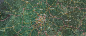
The city is located on the picturesque banks of the Beautiful Mecha River, a tributary of the Don. Efremov is the administrative center of the municipality and has the status of an urban district. It is located 149 km from the regional center of Tula and 310 km from Moscow. On the Moscow-Donbass line there is the Efremov station of the Moscow Railway. The federal highway M4 “Don” passes nearby, and a branch from the highway M2 “Crimea” is also adjacent.
In 2022, the city was awarded the status of a priority development area. Efremov is also a single-industry town, with city-forming chemical industry enterprises. The main products are synthetic rubber, feed additives and sulfuric acid. Since 2011, the American company has opened the largest production site in Europe, where food enterprises are located. The main products are vegetable oils, semi-finished poultry meat products, premixes and much more.
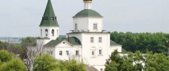
Church of the Life-Giving Trinity (Efremov)[edit]
The Trinity Church was the oldest in Efremov; its foundation dates back to the construction of the fort - the 1630s. Initially, the temple with the chapel of the Smolensk Icon of the Mother of God was wooden. The stone Cathedral Church was built in 1795. Closed in 1929, finally destroyed in 1945.
On November 6, 2000, the laying of the foundation stone for the modern Church of the Life-Giving Trinity took place.
In 2001 the church was built. The interior decoration differs from the previous temple: the wall paintings have been replaced by large human-sized icons.
Together with the Church of the Archangel Michael, it is part of the temple complex in the City Garden on Red Square.
Address:
Tula region, Efremov, Red Square, City Garden.
Education of the city
With the advent of a settled population, some areas of terrain or forest land were named by nickname or personal name. Thus, a small part of the forest began to be called Ofremovsky (Efremovsky). During the development of the territory of the Black Earth Region in the 17th century, the land became the patrimony of the nobleman Ivan Turgenev. Around 1630, he founded the village of Efremovskaya (according to another version, the village of Efremovskoye).
In 1637, by decree of Tsar Mikhail Fedorovich, an oak fort was built in Efremov, which stood until 1689, after which it was dismantled. The fortress was inhabited by boyar children and city Cossacks. They served to protect the country's borders and received land in the surrounding area as compensation. At first, peasants moved to Efremov voluntarily. Under Peter, the lands gradually passed into the ownership of landowners, where serfs began to be brought. During the ongoing administrative reforms in 1719, Efremov became a district town.
Church of St. Nicholas the Wonderworker (Efremov)[edit]
According to surviving legend, the wooden parish St. Nicholas Church stood in a different place until 1792. Due to the new layout of the city, the church was moved and replaced by a stone one, which existed until 1832.
Later, a new stone church was built on the same site. It has not survived to our time.
The modern church in honor of St. Nicholas the Wonderworker was built a little away from the last St. Nicholas Church.
Consecrated in 2009.
Address:
Tula region, Efremov, Komsomolskaya str., 19 a.
Population: between two wars
The post-revolutionary years had a hard impact on the city; surplus appropriation - the confiscation of food from an already poor population - caused famine and a peasant uprising. As a result, by 1926, the population of Efremov, Tula province, decreased by a third, to 10,000 people. Due to extreme poverty, the population lived on a semi-subsistence basis and by 1931 had already decreased to 9,300 inhabitants. After the start of the industrialization policy, several industrial enterprises were built in the city, including factories for the production of ethyl alcohol and synthetic rubber. The population of Efremov more than doubled by 1939, to 26,708 people.
Church of Luke of Crimea (East)[edit]
In April 2015, believers in the village of Vostochny approached the diocese with the initiative to build a church.
We managed to find a former pumping station, where reconstruction began with the help of parishioners and benefactors. A bell tower was attached to the building.
On June 11, 2015 – the day of the saint’s Dormition – the first liturgy was served in the church.
On October 26, 2015, the consecration of the temple took place.
The temple became the first in the Tula region to be consecrated in honor of St. Luke (Voino-Yasenetsky).
In the temple there is a particle of the relics of St. Luke of Crimea.
Address:
Tula region, Efremovsky district, Vostochny village, no. 14.
Church of St. Nicholas the Wonderworker (Mechnyanka)[edit]
The wooden church in the village was consecrated in 1766.
The stone church was built in 1810 at the expense of parishioners and donors.
In December 1937, the rector was arrested, the temple was looted, and a warehouse was set up in the building.
In 1991, local residents began work on restoring the temple: the bell tower, iconostasis, and wall paintings.
On June 14, 2007, the discovery of the relics of St. John Sezyonovsky, secretly buried in a crypt near the southern altar wall of the St. Nicholas Church, took place.
Address:
Tula region, Efremovsky district, Mechnyanka village.
Temple of Demetrius of Thessalonica (Pozhilino)[edit]
The temple in honor of the Holy Great Martyr Dmitry of Thessalonica was built in 1845 by Alexei Levshin, the landowner of the village of Pozhilino, with the help of parishioners.
It was closed in 1922. Since 1936, a village club has been organized in the refectory, and a grain warehouse has been organized in the summer church.
In 1997, the dome collapsed and the temple began to collapse.
In 2012, restoration work began: a dome was erected, an iconostasis was purchased, and a sculpture of the Mother of God was installed.
On December 7, 2014, the temple was consecrated.
On December 17, 2022, the consecration of the chapel took place in honor of Alexy, the man of God.
Address:
Tula region, Efremovsky district, Pozhilino village, Tsentralnaya st., 6a.
Temple of the Kazan Icon of the Mother of God (Turten)[edit]
The Kazan Church was built in 1802 by Prince Pyotr Ivanovich Odoevsky. In 1840, a chapel was built in it to Flora and Lavra. Instead of the ancient chapel, a stone chapel was built on the site of the appearance of the icon in 1848.
In the 19th century, the icon of the Mother of God was placed at the royal gates, and in the chapel at the source there was a copy of it. On the day of the Kazan Icon, many pilgrims gathered in Turten.
In 1937, the temple was closed, and later the chapel at the source was destroyed.
In 1947, the temple was returned to believers.
The temple was returned to believers in 1989 and restored. The spring and bathing area have been improved.
Address:
Tula region, Efremovsky district, Turten village.
Church of the Assumption of the Blessed Virgin Mary (Khmelevoye)[edit]
The Assumption Church was built in 1837 - 1850 on the site of a dilapidated wooden church.
Expanded in 1872.
Under Soviet rule, the temple was closed and destroyed.
Returned to believers in 2002, it was restored by the efforts of parishioners and management of the farm.
On November 15, 2012, the consecration of the restored church in honor of the Dormition of the Mother of God took place.
On December 24, 2012, the chapel of the blessed Prince Alexander Nevsky was consecrated, and on February 2, 2013 - the Great Martyr George the Victorious.
Address:
Tula region, Efremovsky district, village. Hoppy.
Population in pre-revolutionary times
The first people settled on the territory of modern Efremov in the 16th century; the settlements were small. Almost the only trade was beekeeping. The first data on the population of Efremov dates back to 1800. At that time, the population of 1,800 people consisted of burghers who were mainly engaged in the production and trade of grain. The development of manufactories and small handicraft industries led to an increase in the number of residents to 3,000 people. The population then continued to grow, reaching 9,800 people in 1856, and by 1861 it had grown to 10,500 people.
After the abolition of serfdom, peasants began to leave the poor agricultural region to work in industrial centers - Tula and Moscow. In 1897, the population of Efremov fell to 9,000 people. After the construction of the railway, grain trade revived again, and the processing of agricultural products - flour milling and distillery - developed. Due to this, the number of residents increased to 12,600 in 2013. The latest pre-revolutionary data from 1914 showed the number of inhabitants at 14,500 people.