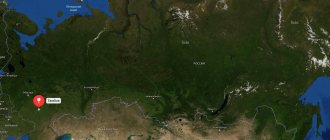
Novocherkassk is located in the Rostov region, 40 km north of Rostov-on-Don. From the east its outskirts are skirted by the Tuzlov River. You can view the location of the city relative to other large settlements in the Rostov region online on a map of Novocherkassk from a satellite.
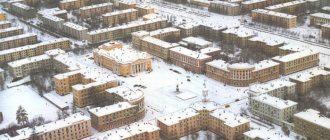
The founder of the settlement was the Cossack ataman Platov. At the beginning of the 19th century. he chose a place on a hill for the construction of the capital of the Don Cossacks. The construction of the city was carried out by civil engineer F.P. Devolan, who chose a radial-rectangular arrangement of streets for the settlement. The map of Novocherkassk with streets shows that they depart from Trinity Square in different directions.
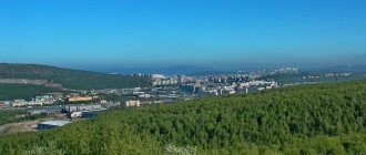
In the middle of the last century, industrial enterprises began to grow in the city. Factories and factories are concentrated in the industrial zone, which is separated from residential areas by the river's floodplain and is located several kilometers from the center. In terms of production volumes, Novocherkassk often took first place in the USSR and remains a leader today.
Map of Novocherkassk with streets
The historical center of the city is separated into a separate area, which is called “Center”. Its main city highways cross it crosswise:
- Baklanovsky Avenue;
- Herzen's Descent;
- Moscow street;
- Ermak Avenue.
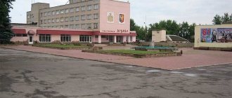
They connect on Trinity Square, in the center of which there is a “Worship Cross”. In the city center there are several restaurants, banks, and hypermarkets. A map of Novocherkassk with diagrams will help you find the bus station and railway station.
A railway track runs through the city, which was built at the beginning of the last century. The railway connects Novocherkassk with Bataysk in the south and the city of Shakhty in the north of the Rostov region, and is also one of the main railway connections between the central part of the country and the North Caucasus.
Bataysk is located away from the M-4 Don federal highway. The Rostov Highway leads out to it from the city. Urban transport is represented by bus and tram services. Residents of the city face difficulties when moving from one area of the city to another, since they are located at a distance from each other. On a map of Novocherkassk with streets and houses you can see the distance between residential areas.
What is Novocherkassk famous for?
- In the western part of the city there are the Triumphal Arches, which were built by order of Platov in the style of late classicism. Every night the arches are illuminated with lanterns. The northern arch separates the central part of the city from the villages.
- In the center of Novocherkassk there is the Ataman Palace - a small building (2 floors), which was built in the classicism style. The design and construction of the palace was carried out by I. O. Valprede in 1863. Today, the mansion is a branch of the Don Cossack Museum: on the ground floor there is an exhibition of museum exhibits; the interior gallery has been recreated on the second floor. Near the Ataman Palace there is a small square with a fountain.
- Directly behind the Ataman Palace is the Alexander Garden, which was founded by Ataman M. G. Khomutov in the 1850s. At the moment it is a city park, on the territory of which there is a cafe, a water park, children's attractions and a small pond.
- In 2003, a monument to Franz Pavlovich de Volan, a military engineer, lieutenant general, was unveiled in the city, according to whose design the city of Novocherkassk was built. Thanks to the layout of the city, Novocherkassk is called “little Paris”.
- In 1906, a stone temple in the Old Russian style was built in Novocherkassk - the Temple of Constantine and Helena. It took 3 years to build the temple. Already in 1909 the church was consecrated. Initially the temple was wooden.
- The city also has the first botanical garden in Russia - Tolokonnikov Park or Ginkgo Park. The park opened in 2001 on the site of a clay quarry. The designer of the project was Alexander Tolokonnikov.
Maps of Novocherkassk with houses
About 172 thousand people live in the city. Most of them work at local enterprises or go to work in Rostov-on-Don. Good conditions for education have been created. On the map of Novocherkassk by district you can find:
- 74 preschool and general education institutions;
- 13 colleges;
- 3 universities;
- 9 research institutes.
There are a lot of visiting students in Novocherkassk from neighboring villages and cities. True, most of them, after receiving their education, go to live in other cities.
The city has cultural and entertainment centers. But most of all, local residents are proud of the historical sights. Thus, in the city center, every building “breathes” the glorious history of the Cossacks. On the map of Novocherkassk with houses you can find the Ascension Military Cathedral, on the walls of which in the evening pictures with scenes from the Holy Scriptures are projected, as well as 2 new churches that are not inferior in the luxury of decoration to the ancient temple.
The houses in the city center have been preserved since the construction of the capital of the Cossacks, when every owner of the house wanted not only strong walls, but also a special, beautiful appearance of the building. Therefore, 2- and 3-story mansions are decorated with stucco, enfilades, spiers on the roofs and columns at the entrance. If you look at a map of Novocherkassk with house numbers, you can find one of the most beautiful architectural complexes of the city - the building of the South Russian State Technical University.
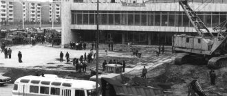
Train Station
The Novocherkassk railway station is a station in the Rostov region of the North Caucasus Railway, which has the status of an intermediate station. The station is located at st. Vokzalnaya, 1. Next to the railway station building there is a park. The station is open every day from 8:00 to 19:50.
Long-distance trains run through the Novocherkassk railway station in the following directions: Moscow, St. Petersburg, Kislovodsk, Rostov-on-Don, Arkhangelsk. Suburban trains are also serviced at the station.
Economy and industry of Novocherkassk
Industry is actively developing in the city. Here is the plant where most of the electric locomotives that run daily on Russian Railways came off the assembly line. The company employs more than 10 thousand people, but young, highly qualified specialists are always required.
On a detailed map of Novocherkassk you can also find where the state district power station on the Tuzlov River is located and the largest giant plant in the country that produces electrodes.
Novocherkassk factories also produce;
- Petrochemical equipment;
- Glass containers;
- Clothes;
- Bread;
- Meat;
- Beer;
- Wine and vodka products;
- Milk;
Despite the huge number of jobs, many young people prefer to go to work in the metropolis, especially since it is only half an hour away by car.
Novocherkassk
(Rostov region)
OKATO code:
60427
Founded:
1805
City since:
1805 City of regional subordination
Telephone code (reference phone)
| 86352***** | 23-209 |
Deviation from Moscow time, hours:
0
Geographic latitude:
47°24′
Geographic longitude:
40°06′
Altitude above sea level, meters:
80 Sunrise and sunset times in the city of Novocherkassk
Settlement history
Novocherkassk, whose population we are considering, has a unique history. It was immediately planned and built as a capital city. In 1805, for a number of economic, political and environmental reasons, it was decided to move the capital of the Don Cossacks from Cherkassk to a new location. The former capital was flooded every year, so first of all they looked for a new location where such disasters were impossible. The Emperor of the Russian Empire favorably accepted the request to move the capital and sent the famous city planner General Devolan to carry out the decision.
Novocherkassk was planned in the best traditions of European culture. Wide avenues, boulevards with green spaces, and spacious squares were laid out here. Despite the attractiveness of the new capital, the local population was in no hurry to move, and construction proceeded slowly. Therefore, in the first decades the city developed primarily as a location for military units. Many administrative and public buildings and government housing were erected here, but there was almost no private development. Only with the advent of industrial enterprises did the influx of residents gradually begin to the city, but this process was very slow. During the years of revolutionary events in the country, a center of white resistance was formed in Novocherkassk, which led to a significant increase in population.
In 1920, the city was finally taken by the Bolsheviks. During Soviet times, the settlement developed as a large regional, industrial and scientific center. Then the Cossack past of the city was carefully hushed up, and only in 1993 Novocherkassk was declared the capital of the World Cossacks.
Climate and ecology
Novocherkassk is located in a temperate continental climate zone, with mild, short winters and long, hot summers. The average annual temperature is about 9 degrees Celsius. Winter in the city begins in December and ends at the end of February. In January, the coldest month of the year, the thermometer can drop to minus 20-25 degrees, but on average it stays around -8. Summer in Novocherkassk begins in May and lasts until the end of September. In August, the thermometer can rise to 40 degrees Celsius, but the average summer temperature is +23. At the same time, in summer the population of Novocherkassk, Rostov region, experiences a rather acute lack of moisture, especially in August. It receives approximately 60 mm of precipitation throughout the year, with the wettest months being January, February and June.
While the climatic conditions of Novocherkassk are generally favorable for living, the environmental situation leaves much to be desired. The city is experiencing big problems due to water pollution in the rivers, and hence there is a shortage of drinking water. The region's industry significantly pollutes the city's soil and air. The Novocherkassk administration is working to solve these problems, but has not yet achieved much success in this direction.
Employment
A large number of stable economic enterprises provide employment for a large number of residents. The Employment Center (Novocherkassk), which collects vacancies from all enterprises in the city, records one of the lowest unemployment rates in the region - only 0.5%. The main vacancies are associated with a shortage of blue-collar workers. But people with higher education, especially young professionals, do not always manage to find a suitable job. Women under 40 with higher education experience the greatest difficulties in finding a job.
Economy of the city
During Soviet times, Novocherkassk, whose population is closely connected with its economy, became a major industrial center. In 1936, an electric locomotive plant was built here, which today is an important enterprise for the economy of the region, employing almost 10 thousand people. In the 50s, a synthetic products plant was launched in the city. At its best, up to 3 thousand people worked here. Today the plant is almost stopped, only one workshop is functioning. At the same time, the electrode plant began operation, which today is one of the largest metallurgical enterprises in the region.
The stability and profitability of the city's economy is also ensured by an enterprise for the production of petrochemical equipment, several large food and construction companies, two clothing factories, and enterprises in the social and cultural spheres. There are two universities and about a dozen secondary specialized educational institutions in Novocherkassk. The volume of production per capita in the city is 67 thousand rubles.
City infrastructure and quality of life
Small cities in Russia generally cannot compete with large, developed settlements, and Novocherkassk is not a happy exception. The city's population experiences a shortage of large cultural, healthcare, and trade facilities. But this problem is being successfully solved by nearby cities. But difficulties with buying housing and finding employment for young people lead to the fact that school and university graduates often leave the city. The infrastructure is poorly modernized, there are problems with roads. All this, of course, reduces the quality of life of people and their loyalty to the place.