The Kemerovo region has been inhabited by people since the Middle Paleolithic. Ancient sites found by archaeologists prove a rich historical and cultural layer.
The Kemerovo region appeared as an administrative unit in 1943. This is one of the largest regions of Western Siberia.
The region is also called Kuzbass - this is where the largest coal basin, Kuznetsk, is located. The mineral was first discovered in 1721 by ore miner from the Kuznetsk fort Mikhailo Volkov.
Currently, the Kemerovo region is a large industrial center supplying the country with coal and metal. The tourist attractiveness of the region is due to the cultural heritage of the small indigenous peoples of Siberia, nature, and archaeological finds.
For ease of route planning, we have marked all mentioned cities and attractions on the map of the region:
Tomsk writing
A unique museum-reserve is located on the banks of the Tom - this is the Tomsk Pisanitsa. Its uniqueness lies in the fact that ancient people lived here and left evidence of their existence in the form of rock paintings.
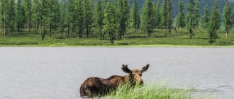
More than 280 drawings dating back to 3000-4000 BC. The images of the sun, moose, bears, birds and even boats are well preserved. Some drawings depict the life of the people who lived here then.
In this reserve, the life of the indigenous inhabitants of the region - the Shors - is studied. A whole complex has been created telling about the life and everyday life of these people. They didn’t forget about the nomadic Mongols - a “Mongolian yurt” was erected. In the 17th century, the Slavs appeared in the region, and tourists can get acquainted with their way of life.
The nature here is incredibly beautiful, which you can admire from observation platforms and while walking. The unique virgin nature attracts tourists here, for whom special routes have been created, one of which leads to the Itkarinsky waterfall.
TOP-3 – beautiful places in the Kemerovo region
Most of the most striking sights of the Kemerovo region are among the so-called “seven wonders of Kuzbass”.
Reserve "Kuznetsky Alatau"
- Coordinates on the map: 54.365000, 88.119722.
In the vicinity of Novokuznetsk there is the only nature reserve in the region. The reserve was founded in 1989 on an area of over 400,000 hectares. The main goal of its creation is to preserve the unique biodiversity of the Kuznetsk Alatau mountains. Alatau covers sections of the Novokuznetsk, Mezhdurechensky and Tisulsky districts.
The reserve's lands include part of the Stanovoy Range, the valley of the Rastai River, glaciers, and many picturesque swamps and lakes.
You can visit the beauty of Kuznetsk only with the permission of the reserve administration. Passes and excursions must be agreed upon in advance. There are several trails for hiking, river rafting, fishing and snowmobiling. The reserve also has a museum, an eco-center, a rehabilitation center for injured birds, and horse rentals.
Shorsky National Park
- GPS coordinates: 52.772964, 87.926010.
The south of the region is occupied by a stunningly beautiful mountainous region, nicknamed Siberian Switzerland. Like the Swiss Alps, Mountain Shoria attracts many athletes, professionals and amateurs.
Local ski resorts are in demand among tourists from all over Russia. In addition to recreational resources, the peaks provide people with rich mineral reserves. So, for more than 150 years, since the mid-19th century, iron mining has been carried out here.
In the same year, a vast national park with an area of more than 410,000 hectares was created in the Gornaya Shoria reserve. “Shorsky” is entirely located on the territory of the Tashtagol region and includes five forest districts.
Within the boundaries of the park there are dozens of attractive attractions: rock outcrops, caves, waterfalls, and an ethnographic museum. More than 500 species of plants grow in Shorsky, including such rare specimens as Rhodiola rosea and Siberian kandyk, 62 species of mammals and 180 species of birds live.
Ecological routes of varying degrees of difficulty have been developed for tourists. There are three cordons on the border of the park, with guest houses built next to each.
Lake Big Berchikul
- Coordinates: 55.611043, 88.343891.
Near the village of Tisul there is a vast freshwater lake, the largest in the entire region. The name of the reservoir is translated from ancient Turkic as “wolf lake”. Not only the reservoir is beautiful, but also its surroundings: on the banks of Big Berchikul there are light coniferous forests, forest-steppes and mountain taiga, in which a dozen rare plants listed in the Red Book grow.
The lake has no drainage; only a small channel connects it with the Dudet River. Not a single major river flows into Berchikul. Despite this feature, the reservoir does not change in size even in the summer heat, when the water actively evaporates and many other lakes simply dry up.
The huge bowl of this Kuzbass landmark is filled with underground springs and small streams all year round. There is a tourist base near the lake; vacationers can enjoy fishing and horseback riding. Berchikul is rich in fish; it is home to carp, pike, perch, tench, bream, silver carp and many other species.
Itkarinsky waterfall
Itkarinsky waterfall - its waters cascade from one ledge of the bank of the Tom River. The water can be drunk without fear; doctors consider it mineral water, table water.
The waterfall is surrounded by a mixed forest. The guide will tell you an interesting legend about the people who previously lived on the edge of the forest where the waterfall ledge is located. There is also a parking lot for tourists.
Tutal Rocks
Fans of mountaineering and mountain tourism will certainly be interested in the Tutal Rocks. They were formed as a result of the washing out of shale rocks by the waters of the Tom River. Depending on the distance from the railway, tourists call them near and far. These picturesque rocks are loved by rock climbing enthusiasts. Here, tourist clubs conduct training sessions with mountaineering enthusiasts.
Prices for accommodation and tours
Air tickets from Moscow to Novokuznetsk cost about 20 thousand rubles round trip per person. Accommodation in a hotel, according to the Russian housing booking service, will cost from 2 thousand rubles for two per room per day, from 12 thousand per day - up to 13 people in a cottage.
“Basically, travelers go on vacation in groups of more than 6 people for 2-3 days and spend an average of 5.3 thousand rubles per day on accommodation. A vacation in the Kemerovo region costs an average of 14.4 thousand rubles. Most tourists book houses, cottages and apartments at the Sheregesh resort. Hotels and recreation centers are less popular. In the winter season people go to Sheregesh to ski. Bookings for winter start from the beginning of September. In the summer they rent houses and go hiking along hiking trails. They often request wooden cottages with a wood-burning sauna,” said Oksana Shustikova, director of development and communications for the reservation service .
According to her, demand for vacation in the region fell by 40% compared to last year, and the average check increased by 17.24%.
“Ethno- and ecotours around Mountain Shoria and Kuznetsk Alatau last 4-6 nights. Tourists get acquainted with the traditional way of life, see the Shor National Park, the Tazgol eco-museum and Shor villages, where people still live without electricity and gas, learn to cook Shor cuisine and archery, make amulets and play national games. The cost of one day of the tour is 5.5-6 thousand rubles including meals, accommodation and excursions. There are also more intense programs, for example the 10-day “Kuzbass Reserve”. The price for it starts from 47,600 rubles,” says Olesya Kolesnikova. — Bus tours from the cities of Kuzbass — Kemerovo, Leninsk-Kuznetsky and Novokuznetsk — are designed for 2-3 weekends. Here guests can already get acquainted with the Shor National Park, the Museum of Ethnography and Nature of Mountain Shoria, the Three Rivers Museum-Reserve and the Tengrian Temple. Price - from 4.5 to 9.3 thousand rubles per person, depending on the intensity of the program.”
The editors thank Rostourism for assistance in organizing the press tour
Linden Island
3 km from the village of Kuzedeevo, Novokuznetsk district, there is an unusual natural monument - Linden Island. It was discovered by the Russian scientist P. N. Krylov in 1889. The age of this extraordinary island, according to scientists, is several million years. The area of the relic grove is 110 square meters. km. The trees are in a special microclimate, here the temperature is 2-3 degrees higher than usual.
After the Ice Age, Southern Kuzbass is characterized by fir-cedar forests, and here broad-leaved linden trees grow. Scientists explain this phenomenon by the fact that the glacier did not touch this territory and the linden trees survived. When the glacier retreated, a linden island was formed, the territory of which in 1964 received the status of a natural monument.
Natural attractions
Itkarinsky waterfall
Coordinates: 55°58′02″ N. w. 84°58′46″ E. there : 2 km from the village. Itkara
The waterfall is located on the Tom River - it falls from the root ledge. Its height is 4 meters.
Above the waterfall, on the shore, there is a clearing. According to legends, peasants lived on it and had a special method of saving themselves from the raids of nomads. They built their houses in such a way that they could lower them underground at any moment: it seemed that the place was lifeless.
Not far from the waterfall is the village of Itkara, where a huge poplar tree grows (several people can grasp it) and there is a burial site according to Siberian traditions.
Tourist routes to these places with a visit to Itkarinsky are organized by Kemerovo travel agencies and various clubs.
Tutal Rocks
Coordinates: 55.713557, 84.933869 How to get there: from Kemerovo to Yurga by train, cost - 110 rubles, travel time - 3.5 hours
Tutal rocks are the bank of the Tom River opposite the city of Yurga. The official names of the rocks are Zmeinye and Nikolskiye.
This place is popular among climbers. Climbing training takes place here. There are also tourist routes.
When visiting the Snake Rocks, you must be careful - there are vipers here.
It is believed that there is an underground city under the Tutal Rocks. According to the memoirs of Tomsk local historian Loktyushin, as a child he and his friends explored the catacombs. But in the 60s, after several children were lost in the passages, the authorities decided to blow up the caves. Modern expeditions confirm the presence of underground passages.
Linden Island
Coordinates: 53.337027, 87.191838 How to get there: from Kemerovo to the village. Kuzedeevo by car 270 km, travel time - 3 hours
Linden Island is the name given to a section of forest that survived the Ice Age. In the 30s, a reserve was formed here.
Broad-leaved heat-loving lindens, which are not typical for modern Siberia, grow in a small area. It is believed that the glacier did not affect this area, so the linden trees are millions of years old. On the “island” the average air temperature is always 2-3 degrees higher than in the surrounding area.
The village of Kuzedeevo itself, next to which Lipovy Island is located, is interesting because the Vepsian people live here. In the 30s they left the Leningrad region and founded a large colony in Siberia. They speak the South Vepsian language and maintain their way of life, culture and traditions.
Royal Gate
Coordinates: 53.051094, 88.415074 How to get there: 10 km from the village. Ust-Anzas Website: https://shorskynp.ru Phone: +7 38473 3‑33-38, +7 38473 3‑33-39
The Tsar's Gate rocks are included in the Shorsky National Park. The rock is located on the banks of the Mrassu River. Its height is about 100 meters, and closer to the top there is a natural through hole in the rock. Because of him, the rock got its name.
Like many interesting natural sites, the Royal Gate is shrouded in legends. One of them tells about the brave hero Aylotai. He fought with the evil spirit Kara-Kan. He built an obstacle in the way of the hero in the form of a high powerful rock, but Aitolai’s arrow pierced the stone and hit Kara-Kan. A hole in the rock reminds of these events.
On the slopes of the upper part of the rock, primitive rock paintings have been preserved.
Gavrilovskie caves
Coordinates: 54.256934, 85.841338
Old-timers claim that before the Civil War, the length of the caves was much greater, but due to the fact that children and livestock were lost in them. Some of the passages were blown up.
Currently, the caves are relatively safe to visit on your own.
Gavrilovsky caves are two natural objects, mainly limestone. In the grottoes you can see stalactites and various rocks.
Lake Big Berchikul
Coordinates: 55.614363, 88.333165
The name of the reservoir comes from the Turkic phrase “wolf lake”. The largest lake in the Kemerovo region.
Rocks found around Berchikul indicate that there was previously an ancient sea in this place. The lake itself was also 2-3 times larger many centuries ago.
Berchikul has only one tributary, but even in the hottest summer months the water level in it does not change.
On the northern shore of the lake, mounds were found - 4 burials with the remains of 44 people, bronze items. The find dates back to the 1st-4th millennium BC.
Reserve "Kuznetsky Alatau"
Address: Mezhdurechensk, Shakhterov Ave., 33-1 Phone: +7 (38475) 5-06-11, 3-19-05 Website: https://www.kuz-alatau.ru/ Cost: 100-1000 rubles
The project to create a reserve was discussed back in the 80s. last century. However, immediate action was constantly postponed. And Siberian forests, including trees listed in the Red Book, continued to be cut down.
The reserve appeared thanks to the miners' strike in 1989. Its creation was one of the strikers' demands.
Among the unique objects of the reserve one can note: 32 small glaciers, Srednetersinskoye Lake, mountain-glacial Lake Rybnoye, the remains of ancient mountains, Krestovsky swamps.
Celestial teeth (Tiger-Tysh Ridge)
Location: 60 km from Mezhdurechensk
The mountains are located in close proximity to the Kuznetsky Alatau nature reserve, but are not part of it.
Celestial teeth are popular among mountain tourists. Therefore, there are many shelter houses where travelers can stay.
The mountain range consists of several ridges with clearly protruding mountain peaks. The highest is located on the Tiger-Tysh ridge - the Big Zub peak, more than 2 thousand meters high.
The territory contains several mountain tarn lakes, glaciers, waterfalls, rapids, and rivers.
Near the Snow Leopard shelter there is a chapel that is different from the others. The icons in it are made not in the traditional way, but in mosaics - due to the low temperatures. The chapel itself was made in parts in different cities, and then it was assembled by professional climbers.
Lake Tanay
Coordinates: 54.776170, 85.027938 How to get there: 100 km from Kemerovo to the Tanay ski complex
The shores of the lake have been considered a wonderful place to live since ancient times. Traces of people from the Stone and Bronze Ages have been found here.
By the middle of the 20th century, due to anthropogenic impact, the lake was on the verge of extinction, but it was restored in time.
Currently, crucian carp live in the reservoir, and various birds nest on the banks.
Not far from the lake there is the Tanay ski complex, where you can book a tour of the surrounding area including a visit to the lake.
Shorsky National Park
Address: Tashtagol, st. Sadovaya, 8A Phone: +7(38473) 3-33-38 Website: https://shorskynp.ru/ Opening hours: Mon-Fri 8:00-17:00
The territory of the park occupies the southern part of the Alatau-Shor Highlands.
The national park includes many karst caves and individual grottoes, the Mrassu, Pyzas, Kondoma and Kabyrzu rivers, flooded quarries and swamps.
Within the boundaries of the Shorsky Park there are several remote villages that are interesting from an ethnographic point of view. One of them is Ust-Kabyrza with a population of about 700 people. Civilization is in no hurry to enter these lands, so the village consists of wooden houses, and the residents are engaged in fishing and agriculture.
On the territory of Ust-Kabyrza, three Bronze Age sites were discovered, as well as the burial of the so-called Kabyrza princess. Coincidence or not, after the grave was opened, the harshest winter in the last hundred years came to the Kemerovo region.
Near the village there is the Azas Cave. It is believed that the yeti lives in it. Visiting the cave is possible only with permission from the Shor Park administration.
Ice mountain Mustag
Coordinates: 53°00′35″ N. w. 87°57′47″ E d.
Mustag is the highest point of Mountain Shoria. The name is translated from Shor as “ice mountain”
Currently, Mustagh is a place for alpine skiing, with ski and freeride trails, a ski lift, and a cafe.
According to legend, the mountain appeared from the Barti heroes who fought with each other. Each of them wanted to marry the beautiful Ak Puba. They did not share the girl and in the fight they turned into a mountain. Ak Puba could not stand the grief and disappeared. Every time a white cloud appears over Mustag, it is believed that Ak Puba is again mourning the heroes.
Local residents, descendants of the ancient Shors, still perform sacred rituals and pray, turning towards where Mustag stands.
Azas cave
Location: 18 km from the village. Ust-Kabyrza, Karga ulus How to get there: as part of an excursion group from the Shorsky National Park
The length of the cave is several kilometers. The Azas stream flows out of it.
There are eyewitnesses who claim to have seen Bigfoot in the cave. The existence of the Yeti has not been proven, but such rumors are spread regularly. At the same time, during the 2011 expedition, traces were found near the cave, whose identity could not be established.
You cannot visit the cave on your own. It is part of the Shorsky National Park, so it is necessary to obtain special permission.
Pine with rings - a botanical natural monument
In the Promyshlennovsky forestry enterprise you can see an extraordinary pine tree, which has become a botanical monument of nature. This tree attracts nature lovers with its unusual appearance. At a height of 16 meters there are unusual rings on the trunk. The tree is about 60 years old, quite healthy and without signs of pine tuberculate cancer.
Scientists suggest that while still a seedling, the pine tree suffered a tumor-like bacteriosis and, as a result, growths formed on the trunk, which are a very valuable and expensive material from which various kinds of crafts, boxes, smoking pipes, hairpins and other souvenirs are made. These products have an unusual texture.
Royal Gate
Ten kilometers from the village of Ust-Anzas, along the Mras-Su River, travelers are offered an amazing, beautiful view, which is the decoration of Mountain Shoria - the Royal Gates.
This Siberian corner attracts extreme sports enthusiasts, where they can enjoy skiing. Mountain Shoria in winter serves as a ski resort for all Siberians.
In these picturesque places there are sheer hundred-meter cliffs. These amazing rocks change color depending on the weather. On a bright sunny day they look pink, and on a cloudy day they look gray.
Rock paintings are visible on the inaccessible rock. In the rock itself, time and water have formed a hole that resembles a drop. And, of course, there will be someone who will tell vacationers another legend about the Royal Gates, with which the Siberian land is rich. In fact, the Royal Gate received its name, presumably, from its similarity to the Royal Gate in the Orthodox iconostasis.
Historical places
Tomsk writing
Where is it located: village. Written Website: https://gukmztp.ru Phone: +7 3842 75‑10-90
In the Lower Tomsk region, a group of rocks stretches for 50 kilometers, becoming famous thanks to the petroglyphs found.
The rocks are covered with ancient drawings and inscriptions from the Bronze and Early Iron Ages. In total, 280 samples of rock art were discovered.
Museum of Ethnography and Nature of Mountain Shoria
Address: Tashtagol, st. 8 March, 4 Phone: +7 38473 3‑20-19 Website: https://www.shor-museum.ru Opening hours: 09:00-18:00 Tue-Sun
The museum appeared in the early 90s to study and preserve the traditions and language of the Shor people. To replenish the fund, museum staff conducted ethnographic expeditions throughout the Kemerovo region and Khakassia for several years.
Among the exhibits of the museum there are rare samples: the alphabet of 1906 for Shor children, a collection of ancient icons, household items of the Siberian hermit A.K. Lykova.
Cholkoy Museum
Address: s. Bekovo, st. Central, 6 Phone: +7 38452 5‑92-81, +7 38452 5‑92-73 Website: https://cholkoi.ru Opening hours: Mon-Fri 10:00-18:00
This is a historical and ethnographic museum dedicated to the Altai-Siberian Teleut people.
Some of the museum's exhibits are located in the open air: a fort, a yurt, altars. Objects telling about the Teleuts before and after the arrival of Russian settlers to these lands are kept in closed rooms.
Most of the exhibits, for example, elements of traditional clothing, were brought by residents of the region belonging to the Teleuts. In the museum, visitors will learn not only historical facts from the life of this people, but will also hear legends about the Master of Altai, his daughters and the origins of people.
Museum-Reserve "Historical Mariinsk"
Address: Mariinsk, st. Lenina, 10 Phone: +7 38443 5‑20-19, +7 38443 5‑27-54 Website: https://mariinsk-museum.ru Opening hours: 10.00-19.00
The museum represents the ancient part of the city of Mariinsk - 73 wooden and stone houses built in the 19th century.
Here you can get acquainted with the life of a merchant, visit the house of the writer Chivilikhin, visit the birch bark museum and learn the birch bark craft.
The museum constantly hosts historical and city festivals, master classes, and children's events.
Ethnographic Museum "Tazgol"
Coordinates: 53.051094, 88.415074 How to get there: 100 km from Tashtagol to the village. Ust-Anzas
The museum was created on the basis of the village of Ust-Anzas, an ancient settlement site of the mountain Shors. Medieval buildings, two-hundred-year-old manors and gold mines have been reconstructed here.
“Tazgol” is intended to tell about different periods of the mountain Shors from primitive to present times.
Local residents still lead a measured lifestyle, engaged in fishing, hunting, blacksmithing, and gold panning.
Worship Cross on Mount Kurgan
Location: village. Sheregesh How to get there: from Kemerovo, Novokuznetsk or Tashtagol by bus or train, travel time - 7 hours
Placing worship crosses on high places is a long-standing tradition of Orthodox Christians. There is a 15-meter cross on Mount Kurgan, which is visible from many points.
The weight of the structure is more than 7 tons, so it was delivered to the mountain by helicopter.
Tomsk Pisanitsa Museum-Reserve
Address: pos. Written Website: https://gukmztp.ru/ Phone: 8-3842-75-86-33 Opening hours: 10:00-18:00 Wed-Sun (winter period); 10:00-18:00 Mon-Fri, 10:00-19:00 Sat, Sun (summer period) Cost: 200-250 rubles - adults, 150 rubles - children
At the beginning of the 17th century, drawings and inscriptions of primitive people were discovered on the rocky banks of the Tom River. This find became the basis for the creation of the museum.
The most valuable exhibit of the museum is nature. Thanks to the creation of the reserve, it was possible to preserve rare species of trees, shrubs, and grasses. Some of them survived the Ice Age and are listed in the Red Book. Scientists have the opportunity to observe wild animals in their natural habitat.
The museum-reserve has an “Adopt a Pet” program. You can choose any animal from the reserve and become its guardian. Funds from guardianship are used to improve the living conditions of animals.
Museum of Ethnography and Nature of Mountain Shoria
In the small town of the Kemerovo region, Tashtagol, there is a museum of life and nature in the southern region of Western Siberia - Mountain Shoria. It was created in 1987. One of the museum halls is equipped for exhibitions. There is a hall where the visitor can get acquainted with the life and material values of the indigenous people of this region - the Shors.
The nature of the region - the Shor taiga - is well shown. The guide will introduce you to the history of the development of the gold mining and mining industries.
Address: Tashtagol city, 8th March street - 4.
Kuznetsky Alatau
The motley mountains of the Kuznetsk Alatau (from the Turkic “ala” - motley, “tau” - mountains) stretch for almost 300 km from south to north, covering Western Siberia from the south and connecting the Kemerovo region with Khakassia.
A set of ridges of medium height, the largest of which is the Old Fortress plateau with a height of 2211 m, is dissected by amazingly beautiful river valleys. The unique vegetation of this part of Siberia is represented by steppes and forest-steppes, pine and deciduous forests. Along the slopes of the mountains there is a taiga with a predominance of fir and cedar; in some places there are birch and aspen copses, smoothly flowing into subalpine meadows and ridges of the mountain tundra. Despite the exceptionally high snow cover, reaching up to 5 meters, maral, elk, roe deer, sable, musk deer and wild reindeer manage to survive here. And in the summer the brown bear fattens up for hibernation. The areas of Kuznetsk Alatau adjacent to the cities, combining pristine nature with good access roads, have long been developed by ski tourists; training camps are also held here, since the landscape allows you to choose a ski track for every taste.
Worship Cross
An Orthodox cross is often placed at crossroads so that a traveler can pray on a long journey. This cross is called the “Worship Cross”.
In Gornaya Shoria on Mount Kurgan at an altitude of 1555 meters , a Worship Cross was erected for the 2000th anniversary of the Birth of Christ. Together with the base (5 meters), this structure has a height of 20 meters and weighs 7.5 tons.
Mountain Shoria is a well-equipped ski resort, here you can ski, relax comfortably and see natural monuments. Vacationers have the opportunity to visit the Poklonnaya Cross by riding a snowmobile for about 20 minutes. Physically fit tourists can get to the Cross on foot along two trails. The Worship Cross attracts thousands of pilgrims every year.
Parks, entertainment and more
Ski resort "Sheregesh"
Address: pos. Sheregesh, st. Turistskaya (Green Mountain) Website: https://www.sheregesh.su Phone: +7 933 300‑50-00, +7 3843 33‑93-33 Opening hours: 09:00-17:00
The popular ski resort in Russia Sheregesh has 15 slopes. Their length is from 700 to 5000 meters, and the elevation changes are from 120 to 630 meters.
There are several hotels and guest cottages, equipment rental, and a cafe on the territory of the complex.
On the resort's website you can find travel companions, order a transfer, and book accommodation.
Cholkoy Museum
Siberians tirelessly study the life of the peoples who inhabited these lands before the arrival of the Slavs. In the city of Belovo, Kemerovo region, you can visit the Cholkoy Museum.
There are always a lot of people here: tourists are interested in the life, traditions and way of life of the peoples who lived here previously. The museum has a lot of exhibits that introduce visitors to the life and way of life of the small peoples of Siberia. The guides will show you household items, labor items, furniture, dishes and tell you about the customs of this region.
Address: Belovo, Tsentralnaya street-6.
Celestial Teeth
Celestial Teeth (Tiger-Tysh) is one of the most beautiful mountain regions of Kuzbass, located 60 km east of the city of Mezhdurechensk. The highest peak is Verkhniy Zub (2,178 m above sea level). Located on the border of the Kemerovo region and Khakassia near the Luzhba railway station. Here you will find extraordinary beauty of nature and crystal clear air. Celestial teeth attract tourists making winter and summer hikes from all over the Kemerovo region. Many clear streams and rivers flow along the slopes of blue tarn lakes. And of course, the local aquatic fauna will not leave indifferent any person who decides to go fishing among the majestic mountain landscapes. Taimen, perch, pike, Siberian grayling - you can catch all this in the lakes and rivers of the south of the Kemerovo region.
Kuznetsk Fortress
The Kuznetsk fortress, which is located in the Novokuznetsk region, was recognized as the main symbol of the city in 2008.
Emperor Paul I gave an order to build a fortress in this place, which was supposed to protect Southern Siberia from the Chinese invasion. In 1820 the fortress was built. The construction of this military structure took more than 20 years. Fortunately, she has never had to participate in wars throughout her existence. As a result, in 1846 the fortress lost its military significance.
Now there is a museum here. The museum was opened in 1991 and has an area of almost 21 hectares. On its territory there are other historical and natural monuments, including a waterfall. Museum employees protect and study archaeological monuments and archival documents. The museum's exhibitions are updated periodically.
Various military-patriotic events are held here. There is a permanent exhibition of gold and silver items.
Address: Novokuznetsk city, Krepostnoy proezd-1.
Churches, cathedrals and temples
Holy spring in the village of Gavrilovka
Location: village. Gavrilovka Nearest town: Salair
For a long time, the source was just a spring to which a path was trodden. In 1995, the spring was consecrated, after which its arrangement began.
Now this place is a complex of a small chapel, a dressing room and a soup kitchen.
It is believed that the spring appeared after priests and parishioners were shot at this place during the Civil War. They were taken out of the church right during the liturgy.
Coal Museum
In Kemerovo on the street. Rukavishnikov there is a unique, the only Coal Museum in Russia, created in 1999.
It is in Kemerovo that the main coal mining takes place. Here is the largest development of industrial production of black gold in the entire Kuzbass, which is constantly growing.
The museum presents a unique collection of mined coal, all its diversity. Museum guides will introduce visitors to the history of coal mining. Here they will talk about the hard and dangerous work of miners.
A tourist can expand his knowledge of modern technology for the extraction and processing of raw materials. Museum workers carry out various types of research, environmental and educational work, as well as career guidance for young people aimed at working as miners.
Address: Kemerovo, Rukavishnikova street-21.
Red hill
In 1991, the open-air museum “Krasnaya Gorka” was created in Kemerovo on the territory of a spent coal mine.
On the banks of the Tom River there is a mining complex preserved in its natural form. This complex unites different stages of development of industrial Kuzbass.
Here is Gorelaya Mountain, where coal was found in 1721. One of the adits has been preserved, as well as civil structures and residential buildings that were built during the period of activity of the Kuzbass AIK.
AIK is an autonomous industrial colony of foreign workers, which from 1921 to 1926 participated in the development of heavy industry in the Kuznetsk coal basin. Workers of 30 nationalities helped the Soviet government raise this region.
In 2003, a sculpture of a Kuzbass miner created by Ernst Neizvestny was installed in the museum. In addition to viewing the museum's exhibits, visitors can get acquainted with the history of the mine through newsreels by visiting the museum cinema.
Address: Krasnaya Gorka street-17.
Cities and villages
Kemerovo
The founding date of Kemerovo is considered to be 1701. The city grew out of the village of Komarovo, which was founded by the first settlers named Kemerovo. There is another explanation for the name - the Turkic word “kemer”, meaning “cliff, shore”.
The village of Shcheglov was located very close by, so during the formation of Soviet power the city bore the names Shcheglov and Shcheglovsk. It received its modern name Kemerovo in 1932.
Despite its history, the city received its status only in 1918 and developed as a Soviet mining town. Therefore, from the point of view of historical architecture, Kemerovo can only imagine buildings in the style of socialist classicism - a mixture of Empire, Gothic, and eclecticism. At the same time, the city has interesting parks, museums, sculptures and beautiful modern religious sites.
- Park of Miracles. The oldest park in Kemerovo is over 80 years old. Before the park, this place was a wasteland. Now there are many attractions, playgrounds, sculptures. Holidays are held regularly. And on weekends there is an orchestra.
- Coal Museum. The exhibitions will tell about all types of coal mined in Kuzbass. Various coal samples are displayed on display cases. Here you can learn about the stages of coal mining and processing, and the work of miners.
- Tyulbersky Nature Reserve. An ancient settlement found near Kemerovo was turned into a museum-reserve. Medieval buildings and household items are stored here; a 17th-century fort with workshops, a sacrificial altar and various outbuildings is reproduced. The reserve has natural protected areas.
- Monument to Mikhailo Volkov. The monument to the discoverer of the deposits was donated to the city in 1968 by sculptor G. Baranov. Volkov is depicted clutching a valuable find to his chest. Not far from the monument there is one of the buildings of KuzGTU.
Even more interesting places in Kemerovo in this material.
Novokuznetsk
The city appeared as the Kuznetsk fort in 1618 on the banks of the Tom River. It is considered one of the oldest cities in Siberia.
In the early years of Soviet power, Novokuznetsk became notorious for its too brutal manifestation of the “Red Terror”. Partisan Rogov killed more than seven hundred people whom he considered class enemies.
Modern Novokuznetsk is a city with developed industry. Despite the typological Stalinist development, many architectural monuments of past centuries have been preserved here.
- Transfiguration Cathedral. Its history begins with a small chapel built by the priest Anikoudimos in 1618. Construction of the stone cathedral took place from 1792 to 1835. Due to the long construction period, the style of the temple is mixed - from classical to “Siberian baroque”.
- Kuznetsk fortress. It was built on Voznesenskaya Mountain in the early 19th century as protection against a possible Chinese attack. However, she never took part in hostilities. Now the fortress houses a museum. In this room there is a collection of rare items made of silver and gold.
- House of F. M. Dostoevsky. The Literary and Historical Museum would not exist if it were not for the writer’s love for local resident Maria Isaeva. He came to Kuznetsk periodically, staying here for a total of less than a month. But Dostoevsky got married to his beloved right here, in the Church of the Virgin Mary.
Useful and interesting facts about Novokuznetsk and its attractions.
Prokopyevsk
Prokopyevsk was founded in 1651, previously bore the name of the village. Monastyrskoe. The city emerged from several nearby villages.
During the heyday of the coal industry, there were 16 mines in Prokopyevsk, but now only one operates.
The city has become home to many famous Russians. Among them: kickboxer A. Vakhitov, cosmonaut B. Volynov, hockey player S. Zinoviev, geologist A. Kontorovich and others.
- Drama Theater. The building, built in the Stalinist Empire style, is the only theater in the city. It stands at the end of a wide pedestrian street.
- Sculptures of Prokopyevsk. There are many amazing sculptural compositions in the city. For example, a monument to a plumber, Adam and Eve, an electrician.
- Cathedral of the Nativity of John the Baptist. A relatively young temple, built in memory of the dead miners. It is located in a quiet, uncrowded place - in a pine forest.
Leninsk-Kuznetsky
Until 1925, instead of the city there was the settlement of Kolchugino, known since 1759. The city was named in honor of V.I. Lenin during the life of the leader.
The city developed at the end of the 19th century, when the Success mine was opened. It turned out that on the site of the former village there are large deposits of high-quality coal.
Modern Leninsk-Kuznetsky gives the impression of a low-rise Siberian city. In the southern part, wooden buildings predominate; the city center is represented by low buildings of Stalinist classicism.
- The site of the first mine. The place where coal was first mined is located at the intersection of Furmanov and Gorky streets. The famous “Success” mine was located here. It has not been functioning for a long time. A memorial plaque has stood in its place since the 30s of the last century.
- Cinema "Victory". The first sound cinema in Siberia, it was opened in 1938. Now it is an entertainment center with cinema halls, billiards, bowling, and a cafe.
- Terrarium. It houses reptiles such as Cuban and Nile crocodiles, iguanas, and the oldest snakes in Russia - an anaconda and a boa constrictor, both 24 years old.
Dostoevsky Museum
In Novokuznetsk there is a museum of F.M. Dostoevsky. It was opened in the spring of 1980.
The writer’s first wife, Maria Isaeva, lived in this house from 1855 to 1857. Here they got married on February 6, 1857. Museum workers will tell visitors about the writer’s first love and how it influenced his work.
The museum has created a unique exhibition occupying five halls: “Road”, “Kuznetsky Piglet”, “Mrs. Moskaleva’s Salon”, “Triangle”, “Wedding”. Having visited these halls, museum guests will better understand the philosophy and symbolism of the writer’s works.
The furnishings in the house were recreated using archival materials. All the items in the museum are original, many books were donated by the writer’s descendants, there are many works of applied art, photographs and posters. The library contains about 24 thousand volumes .
After leaving the museum, you can continue the tour of the places described by Dostoevsky in Crime and Punishment. The classic of Russian literature stayed in Novokuznetsk for 22 days.
Address: Novokuznetsk city, Dostoevsky street-29.
Trekhrechye Museum-Reserve
In the village of Ust-Kabyrza, Tashtagol district, the only Gulag camp museum in the Kemerovo region is located. The open-air exhibition in the form of a typical logging camp is dedicated to the memory of the victims of political repression.
“There were several large camps in the Tashtagol region - Gorshorlag, in the villages of Shalym and Sheregesh. They specialized in the construction of ore mines, railroads, and logging. In 1942, special settlements with dispossessed peasants and representatives of deported peoples, such as the Germans, appeared in Ust-Kabyrze. Our camp for prisoners sentenced to more than 5 years was organized in 1947. 300-350 men and women were “sat” in it at the same time on political, administrative and criminal charges. Over the years, the regime and category of prisoners have changed. Since the mid-1960s, “political” prisoners began to disappear. The camp was closed only in 1995,” says director of the Trekhrechye Museum-Reserve Ekaterina Iptesheva .
The camp occupies 1.8 hectares of land. It is surrounded by a high wooden fence and barbed wire, forming a restricted area with observation towers. Entrance is through a checkpoint. Guests can get acquainted with the punishment cell, the club-dining room, the bathhouse-laundry and the paramedic station. The headquarters and living barracks display the furnishings of the camp chief's office from the 1930s to the 1950s, stands with photographs, diagram maps, documents and original objects.
“People lived in barracks designed for 50 people and slept on planks. In winter, despite the presence of two stoves, the rooms still froze. The best places, near the stoves, were occupied by criminals. The “thieves” controlled the lives of political prisoners. When political prisoners came to bed, they went to bed in damp clothes. They ate sparingly - they gave water, 600-800 g of bread, 70 g of cereal, 30-50 g of meat. The workers worked all day long - that's 10-11 hours every day. The main indicator of a prisoner’s life is to consistently carry out the plan. If it couldn’t be done, the rations were cut. Violations were punished by being sent to punishment brigades and a punishment cell. In such conditions, according to official statistics, from 5 to 7% of the total number of prisoners did not survive,” explained Ekaterina Iptesheva.
This year a new permanent exhibition opened, which reflects the history of the deportation of Germans. Since the beginning of the Great Patriotic War, more than a million Germans - 95% of the entire German people in Russia - were deported from the Volga region and southern regions to the Kemerovo region.
GULAG in facts and figures. Infographics Read more
Drama Theater of Novokuznetsk
The Drama Theater of Novokuznetsk was created in 1931. The troupe consisted of 60 people and the symphony orchestra - 15 musicians. Due to the fact that the old building was destroyed by fire, a new one with 1,200 seats . The first performance of the theater was “Intervention” by L. Slavin.
During the Second World War, the theater gave up its stage to evacuated theaters from Moscow, Ukraine and other Russian cities, and it began staging its own performances in Leninsk-Kuznetsky.
In 1963, a new building in the imperial classical style was built in Novokuznetsk. The theater is very popular not only in the Kemerovo region, but also often tours various cities of Russia and former Soviet republics.
Address: Metallurgists Avenue - 28.
Caves and quarries of the Kemerovo region
On the territory of Kuzbass there are many caves, quarries and mines created by people or nature itself.
Azas cave
- Coordinates: 52.765790, 88.497888.
One of the most visited attractions in the national park is a huge cave. The total length of all tunnels is 120 meters. Travelers are interested not only in the beauty and size of the cave, but also in the legends associated with it.
There are rumors that a yeti, or Bigfoot, lives in the area, so paranormal hunters often meet near the natural monument.
Great Kizas Cave
- Coordinates: 52.642450, 88.683452.
Another less known, but no less interesting cave can be found on the banks of the Mras-Su River near the mouth of the Kizas River. The attraction is located on a hill; to get to it, you need to walk along a dangerous steep path.
The entrance to the tunnel is hidden among limestone blocks. The cave consists of two tiers with a total length of more than 200 meters. It is very cold and humid inside in any weather. The distant halls are decorated with small ice stalagmites and beautiful stains on the walls.
Gavrilovskie caves
- Coordinates: 54.257814, 85.858618.
The most famous caves in the Guryevsky region are located above the Bolshaya Tolmovaya River, 2 km from the village of Gavrilovka. The two caves are located a short distance from each other in rocks composed of crystalline limestone. The entrances are located near the river and are wide crevices in the rocks.
Gavrilovskaya-1 goes 15 meters deep into the mountain, the length of the tunnel is about 250 meters. The dimensions of the Gavrilovskaya-2 cave are not precisely known. It’s cold inside the caves even in summer; the floor is in some places littered with boulders and wet red clay, which makes it difficult to move inside the passage.
Kuzbass open-pit mines
The Kuznetsk coal basin is one of the richest coal deposits on the planet. Solid fuel mining has been carried out in the region since 1721. Coal is both a gift and a curse for the Kemerovo region.
On one side of the scale is a mineral resource that provides heat, on the other is irreparable harm to the environment and the tragedy in the mines that claimed the lives of hundreds of people. Coal mines of amazing size have become not only the main economic resource of the region, but also its colorful attraction.
Memorial Museum of Military and Labor Glory of Kuznetsk Metallurgists (Novokuznetsk)
Metallurgists of Kuzbass made an invaluable contribution to the victory in the Second World War. In memory of their feat, a memorial museum was opened on Victory Day in 1985, in which the names of all Kuzbass metallurgists who gave their lives during the Second World War are engraved on memorial plates.
The Eternal Flame also burns here, lit from the open-hearth furnace that produced the first steel for armor in 1941.
The museum has collected more than 2,500 exhibits telling about the life and struggle of metallurgists. Excursions here are conducted with musical accompaniment; the original voice of Levitan sounds, announcing the beginning of the war and Victory. This evokes deeper emotional feelings about wartime.
Address: Pobedy Square - 1/1.