Reading time 5 min.
Udmurtia is a spring region with beautiful nature. The birthplace of dumplings and national baked goods. Where the traditions of the Udmurt people are observed to this day. Taiga region with the mother river Kama. Modern cultural, museum centers and natural monuments coexist harmoniously here.
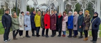
Visiting museums plays a big role in the patriotic education of children of different ages, as well as for cultural family recreation. The museums of famous people are of great pride: P. I. Tchaikovsky and M. T. Kalashnikov.
TOP 3 most interesting places in Udmurtia
Those who want to touch the nature of the Udmurt Republic, to better know its features and differences from other regions, should first of all visit the three most striking natural attractions.
National Park "Nechkinsky"
- Coordinates: 56.684720, 53.755029.
The main national park of Udmurtia was founded on the banks of the Kama River in 1997. On the territory of the reserve there are mountains, swamps, springs, and tracts. The reservoirs are rich in fish; in the meadows and forests in summer and autumn there are a lot of berries and mushrooms.
During the walk, you can refresh yourself with the gifts of nature and quench your thirst in the Makarovsky mineral spring. Many visitors are attracted by the Sidorov Mountains, where the fossilized remains of ancient plants are preserved. Migratory birds also nest in the reserve.
Tourists come to Nechkinsky to enjoy nature in comfortable conditions: the park has a recreation center and a ski resort. Convenient tourist routes are organized for lovers of hiking and walking.
The national park is interesting not only from an environmental but also from a historical point of view. A site of primitive people, as well as the ruins of ancient settlements, were found on its territory. One of the most valuable archaeological finds is dinosaur bones.
Chegandinsky caves
- Coordinates on the map: 55.915000, 53.529722.
The most famous Udmurt caves are located on the banks of the Kama River, in the vicinity of Ust-Belsk. Mysterious, hidden on a 6-meter hill, they are overgrown with legends and superstitions. The origin of the stone corridors is still unknown. According to one version, the underground passages were created by human hands; perhaps copper ore was once mined in them.
According to local legends, in tsarist times gangs of bandits from the Volga Cossacks operated in these parts. Cruel criminals attacked merchant ships sailing along the river, took away all goods and money, and then hid the loot in caves. During the Civil War, White Guards hid inside.
Time has made its own adjustments to the size of the caves: most of the natural monument was buried as a result of landslides. Today, all that remains of the once long underground passages are corridors approximately 100 meters long. Finding the entrance and getting inside is not easy, so tourists sometimes use the help of guides.
Mount Baigurez
- GPS coordinates: 57.651935, 53.758140.
This hill is located 3 kilometers from the village of Debessy. The word “bai” translated from Udmurt means “rich”, “gurez” means “mountain”, although the elevation is an ordinary hill. Locals call it Mount Baigurez: for a flat area, the high hill seems huge. The most remarkable thing about it is the colorful sandy slope that looks like a bloody slice.
The remaining slopes are covered with dense forests, so the red-orange sand contrasts brightly against the background of green leaves and pine needles. From the top there is a breathtaking view of the Cheptsy River and the forests at the foot of the mountain.
The green peak has been shrouded in mystery since ancient times; indigenous peoples have composed many legends about the mountain. So, local residents believed that she was protected by a certain spirit. Modern scientists take a more prosaic approach to history and believe that several centuries ago there was a fortified settlement on the hill. Today Baigurez attracts tourists with its picturesque landscape and fragrant medicinal herbs that grow on its slopes.
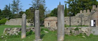
Museum-reserve "Idnakar"
Historical and Cultural Museum-Reserve of the Udmurt Republic…
Glazov
Not far from the city of Glazov, on the site of the Chepetsk settlement, the Idnakar museum-reserve is located. According to legend, it was founded by the Udmurt hero, Prince Idna. The city is named after him. In the 9th–13th centuries, Idnakar was the capital of the craft, trade and cultural life of the Udmurts. Merchants from many countries of the world brought their goods here.
At the end of the 20th century, at the site of the ancient settlement, archaeologists discovered the remains of dwellings and household items of the ancient Udmurts. They made up the collection of the Idnakar museum-reserve. In total, the exhibition includes about 500 items: stone tools of the Mesolithic era, pottery, models of medieval dwellings, weapons, armor, jewelry and clothing of the Finno-Ugric peoples.
The most famous Udmurt reserves and sanctuaries
Dozens of natural parks, reserves and other reserves have been founded on the territory of Udmurtia. All environmental protection zones are under the control of regional authorities. Let's talk about the most remarkable of them.
Zayakinskaya cedar grove
- Coordinates: 57.682308, 53.397513.
The cedar grove in Zayakino is one of the oldest natural monuments in Udmurtia; it recently celebrated its centenary. In 1920, Alexey Smirnov, a simple teacher from a local school, planted several trees in his garden from pine cones, which were sent to him by a friend from Siberia.
Later, he transported the seedlings to the village of Zayakino and planted them on a free plot. The settlement disappeared from the face of the earth long ago, but the name “Zayakinskaya” was forever assigned to the grove. Today, the natural monument consists of about 80 tall, centuries-old cedars that stand out among other trees and fill the air with a delightful aroma.
Natural Park "Ust-Belsk"
- Coordinates: 55.921356, 53.512988.
In August 2001, the authorities of the Udmurt Republic took the territory near Ust-Belsk under their protection. A natural park was created to protect valuable flora and fauna. At this place, two large rivers connect - the Kama and the Belaya, in which rare species of fish such as sterlet and sturgeon are found. The territory is home to hundreds of species of animals, birds, fish, insects, and rare plants grow.
Dozens of representatives of the animal and plant worlds are on the verge of extinction and are included in the Red Book. Scientists are doing everything they can to save endangered species.
The reserve is divided into three unequal parts, each zone has its own characteristics and restrictions for tourists. In the first area, any human activity that could cause harm to the environment is prohibited. In the second area it is allowed to pick berries, fish and even hunt. The third area is the most free for people; all necessary economic work is carried out here.
Ershovskaya oak grove
- Coordinates: 56.485098, 53.849267.
Near the city of Sarapul there is a wonderful green oak grove, almost untouched by human hands. The Ruff oak grove is considered a protected area and is protected by the state. The name of the reserve comes from the nearby village of Ershovka. The heart of the oak forest is Ershovsky Pond.
Most of the trees are oaks, but there are also lindens and pines among them. Some oaks celebrated their centennial anniversary; some specimens are 120 years old. Tourists come to the grove to admire the mighty trees and pick acorns and strawberries.
Nature Park "Sharkan"
- Address: Sharkan village, Sharkan district.
An extensive natural park stretches between the Ita and Sharkan rivers. The flora of the reserve is incredibly rich: more than 500 plant species grow on its territory, six of which are listed in the Red Book of the Republic.
The fauna is no less diverse and valuable; out of almost two hundred species of mammals, amphibians, reptiles, fish and birds, 23 species are close to extinction and are also included in the Red Book of Udmurtia.
The park is divided into five zones, each of which has its own special functions. In some areas you can farm, others are intended for recreation, in others they try to preserve nature in a pristine state.
Andreevsky pine forest
- Address: Krasnogorsk district.
In the Krasnogorsk region of the Republic there is a reserve with an area of about 1000 hectares, in which rare plants listed in the Red Book of Udmurtia have been preserved. Particularly worth noting is the dwarf birch; this tree grew here back in the era of mammoths.
Among the animals there are also interesting species, for example, peregrine falcon, clint and meadow tench. The territory is almost entirely occupied by pine forests and sphagnum swamps, overgrown with medicinal herbs and delicious berries: blueberries, lingonberries, cranberries and blueberries.
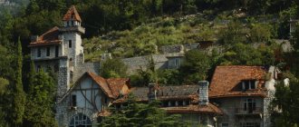
Museum-reserve "Ludorvai"
Architectural and Ethnographic Museum-Reserve "Ludorvai"
Zavyalovsky district
What is a tarantass? What do the bottom ends look like from the fairy tale about Kolobok? Why did the Udmurts build houses without floors and ceilings? Why, when entering a national home, the first thing you need to do is touch the stove? All this can be found out in the architectural and ethnographic complex “Ludorvai”.
The open-air museum consists of ancient wooden buildings. Some of them were originally built here, and some were brought from other settlements. Guests will see huts and a barn, a stable and a bathhouse on the territory of the museum-reserve, as well as a kuala, a family sanctuary in which important ceremonies were held.
One of the oldest buildings is a windmill with a recreated mechanism and wooden utensils. The exhibition tells about the life and history of the Udmurts, Besermyans, and Russian settlers. Inside the buildings you can see rugs and dishes, carts and national clothes.
On the territory of the museum there are excursions, festivals and folk festivities for holidays - Maslenitsa, Peter's Day, Honey Savior. Visitors are offered interesting photo sessions and tastings of Udmurt dishes.
What natural springs of Udmurtia are worth seeing?
In Udmurtia they take good care of springs. Almost every natural spring is equipped and marked with a sign.
Source of the Kama
- Address: Kuliga village, Kez district.
A small spring near the village of Kuliga is the “birthplace” of the most famous and largest river in Udmurtia. It is difficult to imagine how a huge, full-flowing river grows from such a thin stream.
The source is beautifully equipped, above the pipe from which clear water flows there is an arch of large stones, and wide steps lead to the source. There is a comfortable wooden platform in front of the key.
Tourists often stand over the spring, with their feet on either side of the stream, and joke that they have been on both banks of the river at the same time. Every year on July 12, on the day of remembrance of the Holy Apostles Peter and Paul, a festival of Old Believer culture is held near the source.
Zuev's keys
- Coordinates on the map: 55.882050, 53.289949.
Natural springs in the south of the republic near the village of the same name. There are eight springs in total in the area, the most famous of which are called Gremyachiy and Holy and resemble fairy-tale springs with “living” and “dead” water.
There are fonts above the springs, and a chapel was built nearby. The Gremyachiy Spring flows over the stones, forming a small but very picturesque waterfall. Every year, pilgrims from all over the republic and even from neighboring regions come to the Zuev Keys. Many people believe that holy water heals serious illnesses.
Living Key
- Coordinates: 56.447778, 51.851944.
An amazingly clean spring is located a few kilometers from the village of Kizner. The key is called “living” for its extraordinary sensitivity to surrounding sounds: it is believed that water reacts to noise and begins to bubble when it “hears” loud speech.
In 2008, the spring was given the status of a natural monument. The area around was brought into proper shape and made convenient for tourists. On a small hill there is an observation deck, a cozy gazebo and places for making fires. Wooden steps lead down to the spring.
Spring "Gift of the Earth"
- Address: Tatarskie Klyuchi village, Yukamensky district.
The largest spring in Udmurtia is located near the village of Tatarskie Klyuchi. Initially, the spring itself was called the Tatar Key, but later it was renamed “Gift of the Earth.” The name of the source says: every second the earth gives people 50 liters of clean, cool water.
29 streams flow directly from the ground, merge into a single stream and flow into the Lema River. According to some estimates, this amazing spring can feed several thousand people a day.
Local Tatar residents love their spring; many villagers’ traditions are inextricably linked with life-giving water. Water from the “Gift of the Earth” is used for the first bath of a newborn baby, and Sabantuy, Eid al-Adha and Kurban Bayram are celebrated near the spring itself.
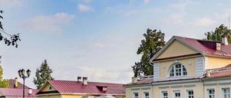
Bashenin's dacha. Art and exhibition complex.
The complex is located in the city of Sarapul. It is a monument of federal significance. The dacha was built in Art Nouveau style at the beginning of the 20th century. And it belonged to the head and honorary citizen of the city, Pavel Andreevich Bashenin . The complex is located in the middle of a park with beautiful alleys; in front of the dacha there is a fountain with figures of a girl and a boy. After the end of the revolution, the dacha was used as a hospital surgical department, a military commissariat, a homeless shelter, a dispensary for the treatment of tuberculosis patients, and a sanatorium for children. At the moment, the dacha has been restored and welcomes its guests, art master classes are held here, many weddings, theatrical performances, concerts and exhibitions related to the merchants of the city of Sarapul and is the hallmark of a small town on the Kama.
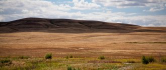
Mountains - beautiful places in Udmurtia
There are no real high mountains of solid rock on the territory of the republic, but there are several notable hills.
Mount Kargurez
- Coordinates: 57.359763, 53.896001.
This peak on the territory of the Sharkan nature reserve has several names: Kargurez, Kar-gora, Yablonovaya mountain. The word "car" has two main meanings: "nest" and "city". Centuries ago, at the foot of the remnant there was a settlement, and on the slopes covered with forests, prayers and festive celebrations took place.
Today archaeological research is periodically carried out on Kargurez, scientists are looking for traces of a settlement of the 18th century. Tourists come to Kar Gora to enjoy the magnificent panorama and get water from the local spring. From the top you can view the surrounding area within a radius of 25 km.
Tatar hill
- Address: s. Pudem, Yarsky district.
The picturesque hill is located in the Tatar Grove tract, a few kilometers from the village of Pudem. According to ancient legend, during the time of the Golden Horde, Tatars passed through these regions. The Tatar Khan’s beloved daughter died, and the inconsolable father ordered his soldiers to build a huge hill over the girl’s grave.
Today, the slopes of the mountain are covered with low grass, while the top is decorated with a kind of “cap” of trees. In a small grove, as well as in a tract, there are pines, birches, spruces, rowan trees, etc. In autumn, the leaves of the trees turn bright colors, making the Tatar Hill even more beautiful.
Babinskie Mountains
- Address: Russkaya Babya village.
Several low mountains near the village of Russkaya Babya were formed many centuries ago as a result of glacier movement. Well-trodden paths lead to the green peaks; locals and visitors love to walk here and pick berries. A river flows at the foot of the hill, which offers a wonderful view from the high slopes. Sometimes folk festivals and excursions for children are held on the mountain.
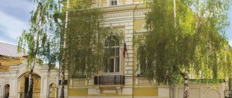
Museum-estate of P. I. Tchaikovsky.
The museum is located in the northeast of the capital of Udmurtia in the city of Votkinsk, where the famous composer P. I. Tchaikovsky spent his childhood. The estate where the composer spent his childhood is located near the lake that inspired him to write the work “Swan Lake”. The museum was created in 1940 . At first he was small and was in a local music school; later the museum began to be replenished with exhibits. After restoration, the estate has several halls. Among the exhibits is the composer's piano and personal belongings that were transferred from the city of Klin. The estate of P.I. Tchaikovsky is visited by many admirers of his talent; concerts, classical music evenings, and theme evenings are held. On the territory of the estate, based on preserved photographs, a stable, a shed for carriages, imports, flocks, greenhouses and gazebos, which are surrounded by an orchard, were erected.
Beautiful Udmurt lakes
The republic's lands are fed by numerous rivers, streams and lakes. Rare natural reservoirs have formed in oxbow lakes.
Black Lake
- Coordinates: 57.054254, 53.229771.
One of the most beautiful bodies of water in the Yak-Bodinsky district is Black Lake. The water in it seems black, like fuel oil, which is why the lake received such a gloomy name. The attraction is surrounded on all sides by pine and birch trees, and the sandy shores are mostly overgrown with tall grass.
In the middle of the pond there is a small floating island spinning, which changes its position under the influence of strong winds. The surroundings of Black Lake are a great place for leisurely walks in the fresh air and contemplation of the scenery. There are places for fires and picnics on the shore.
Lake Svetloe
- Coordinates: 56.181539, 54.153293.
The beautiful lake near the village of the same name fully lives up to its name. Trees grow along the banks of the reservoir, but even they do not shade the water surface and in clear weather the lake shines in the light of the sun's rays.
Like many other reservoirs, Svetloye is an oxbow lake of the large Ural river Kama. In the warm season, vacationers come to the shore to catch fish and have a picnic in the fresh air. Swimming in the lake is unpleasant due to the muddy bottom, but there are a lot of good fish in it.
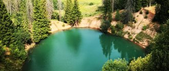
Lake Wild
- Coordinates: 56.210137, 54.132991.
The unusual natural reservoir was nicknamed Wild not for its violent nature, but for its location: the lake is located deep in the forest, among swamps and gloomy trees. The water is surprisingly clear, but appears black due to the dark peat bottom.
The lake is home to many valuable and tasty fish. Because of the swamps, it is not easy to get to Dikoye, and it is even more difficult to get into the water, since the shore is overgrown with dense bushes, but avid fishermen find ways to fish in the reservoir.
Izhmash Museum. Exhibition complex named after M. T. Kalashnikov.
The Armory Museum, which is located in the city of Izhevsk, the capital of Udmurtia. The museum was created during the time of Nicholas the First in 1847. The richest exhibition of the entire weapons revolution is presented here. Part of the museum and exhibits are dedicated to the designer of the famous M. T. Kalashnikov assault rifle. There is also a shooting range where you can try your hand at shooting.
Unusual trees of the Republic
A significant part of the Republic of Udmurtia is covered with forests. Some trees stand out from others due to their age, unusual shape or amazing history and are recognized as natural monuments.
Egorovskaya pine
- Address: Egorovtsy village, Seltinsky district.
A remarkable pine tree near the village of Yegorovtsy stands out among other natural monuments due to its venerable age and colossal size. The prickly old-timer, standing alone in the middle of the meadow, is already more than 500 years old.
The height of the pine tree is about 30 meters, the girth is more than 5 meters. The unique tree has two honorary titles at once: “the tallest pine tree in the republic” and “the widest coniferous tree in girth.”
Relict pine in Zur
- Address: s. Zura, Igrinsky district.
An old tree grows alone on the top of a hill near the village of Zura. For more than three and a half centuries, the long-lived pine has been observing the course of life and the change of eras. For a long time, local residents did not know how long the pine queen reigned on the hill.
In 2012, specialists from the Moscow center were able to establish the approximate age of the tree – 360 years. The mighty beauty is the only large plant on the hill; except for short grass, nothing takes root on the hill. In August 2011, the unique pine was included in the register of old-growth trees.
Sosna-Bort
- Coordinates: 57.203833, 53.160517.
Another amazing century-old pine tree grows near the village of Yakshur-Bodya. The height of the tree is about 20 m, the wide straight trunk is crowned with a spreading crown. At a height of about 3 meters, a narrow vertical crack appears black in the trunk - the side where wild bees used to live. It is believed that it was thanks to the extraction of honey from this hive that beekeeping flourished in local villages.
Since ancient times, beads have been hollowed out directly in the trunks of living trees; only centuries later people began to make beads in chocks and place them in apiaries. Today, hives are made from boards, and beekeeping has sunk into oblivion. There are practically no trees with edges left in the region; the pine near Yakshur-Bodya is one of the few surviving specimens.
Devil's tree
- Coordinates: 57.586894, 53.214078.
The most mysterious and gloomy tree in Udmurtia is located near the village of Igra. The withered, blackened pine has a dark past; many terrible stories and legends are associated with it. Hundreds of years ago, the infamous Siberian Highway ran past the tree, along which shackled prisoners were driven to hard labor. In the same area, robber gangs operated, robbing trade carts and ordinary people.
According to one legend, a tall pine tree absorbed the blood and suffering of innocent victims and dried up from the evil and grief that the merciless criminals brought. Today, the ebony tree stands out among its green neighbors and reminds of the atrocities that happened on Igrinskaya land. The only living things in the dead trunk are wild bees that have settled in the dry hollow.
Alenskaya spruce
- Address: Alen tract, Kezsky district.
Not far from Kez there grows a giant long-lived spruce. The height of the miracle tree is 25 meters, the width of the girthless trunk is about 3 meters. The coniferous giant has been towering in the Alen tract for almost two centuries.
In the old days, the Udmurts considered spruce sacred and created legends about it. Many years ago, during a severe thunderstorm, lightning struck the record holder at a height of 6 meters and split the trunk into two parts.
Even after such a serious test, the tree did not die and continued to grow. In March 2012, the natural monument was included in the list of old-growth trees. Today, the road to the centenarian is one of the most popular tourist routes in the Kez region.
Pander cedars
- Address: Sarkuz station, Kiznersky district.
Two Siberian cedars near the Sarkuz station are all that remains of the disappeared village of Panderka. Centuries-old trees were planted during the life of the village and witnessed its death. In 1912, several families from Staraya Panderka moved to Siberia, but soon returned to their native lands. One of the families brought with them about 50 cedar seedlings, 20 of them successfully took root in the new land. The “Siberians” quickly grew and within a few years reached 2-3 meters in height.
After the Revolution, collectivization began, and agriculture began to actively develop. Local communists cut down almost all the cedars; only two trees miraculously escaped the bitter fate of their fellows. The surviving cedars survived the offenders and many villagers. Years later, the village was deserted, but the long-lived trees still delight the eye with their lush crowns and powerful stature.
The main national museum of Udmurtia.
The museum is located in the capital of Udmurtia, in the city of Izhevsk, in a building at an arms factory. The museum's exposition is rich, dating back more than ten thousand years to the history of Udmurtia. There are archaeological finds with ancient exhibits and utensils here. All sorts of exhibitions on different topics , painting exhibitions and visiting museums are held
Other sights of the Udmurt Republic
In all corners of Udmurtia there are hidden various natural monuments that are atypical for this region. Small waterfalls, caves, canyons are real diamonds for ecotourism lovers.
Waterfall in the village of Kezdur
- Coordinates: 57.835760, 53.680925.
Waterfalls are a rare phenomenon for Udmurtia. Kezdur Waterfall is a small stream running down the red-orange slope of a high hill. A small, but quite stormy and noisy stream flows down the clay soil, breaks off a small ledge and flows into the Lyp River.
There is a steep descent to the foot of the hill; the steps are made of old car tires, partially dug into the ground and filled with stones. For the convenience of tourists, a railing is built next to the stairs.
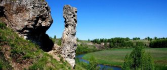
Abat caves
- Address: Staraya Bodya village, Kiznersky district.
An unusual surprise awaits guests of the village of Staraya Bodya: in the middle of the plain, three-meter caves suddenly appear in front of tourists. The caves got their name from the Abat River, which flows through the village. Almost no sunlight penetrates into the moss-covered stone chambers, so they are cool even in hot weather.
Cape of Love
- Coordinates: 55.991098, 53.658511.
The most romantic place on the banks of the Kama. The elevation offers a dizzying view of the river, surrounding meadows, spreading pine trees and small settlements at the foot of the cape. In spring, the cape is covered with fragrant flowers and herbs. The picturesque peak has long been chosen by loving couples and newlyweds; dates are often held here, photo sessions are held and declarations of love are heard.
Chemoshur-Uchinsky Canyon
- GPS coordinates: 56.637409, 52.264859.
The canyon of the Chemoshur River near the village of Chemoshur-Ucha is an amazingly beautiful place, shrouded in an aura of mysticism. Clear streams flow down the green walls of the canyon, and a clear river flows at the bottom, in which you can see literally every pebble. In some places, the greenish sandstone changes to bright red with white stripes.
The incredibly beautiful cliff could serve as a natural setting for science fiction films. There are also two small but colorful waterfalls in the canyon. The area of the attraction is especially beautiful in winter, when part of the water freezes and turns into ice floes, along which a noisy stream continues to run.
You may also be interested in interesting places in the regions neighboring Udmurtia - Kirov region, Perm region, Bashkortostan and Tatarstan
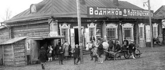
Museum in Bachkeyevo. Point of the Siberian Highway stage.
The museum building was built back in 1837 in the Igrinsky district of Udmurtia. The building was designated for overnight accommodation and recreation of prisoners and convicts who were sentenced to hard labor and exiled to Siberia. The shackles and hard bunks in which prisoners were shackled have been preserved here. You can taste porridge cooked over a fire, of course, not the same as what was fed to the prisoners; it used to be made from oats, but now it is cooked from millet. Museum workers will show you a well that has been preserved from those times and a forge where blacksmiths forged shackles. The museum hosts excursions, exhibitions and themed games with outfits in the style of two centuries ago. The museum building could not be restored; there was no need for it; it was perfectly .