Description and location of the island
Sakhalin is located off the eastern coast of the Eurasian continent. Its area is 76.6 thousand km2. The island has an elongated shape in the north-south direction, about 950 km long.
From a geological point of view, Sakhalin is the northwestern part of the Pacific “Ring of Fire”, which also includes the Kuril Islands and the Japanese Islands. Island formations included in the “ring of fire” are characterized by earthquakes, often destructive, as well as volcanic eruptions. There are volcanoes on Sakhalin - mud volcanoes, not dangerous for people.
It is believed that the name of the island arose from the name of the Amur on an ancient map. The name "Sakhalyan-Ulla", belonging to the river and erroneously attributed to the island, was established thanks to later maps, where the island was called Sakhalin.
For residents of Japan, there is another name - Karafuto Island. The island is surrounded by the Seas of Okhotsk and Japan. Between the island and the mainland there are 2 straits - Tatarsky and Nevelsky.
The Nevelskoy Strait is narrow, less than 7.5 km wide, and is covered with ice in winter. The Sea of Okhotsk and the Sea of Japan are connected by the La Perouse Strait, which separates the Russian territory - Cape Krillon in the south of Sakhalin, from the northern Japanese island of Hokkaido. The strait is deep, on average 20-40 m, and wide (even at its narrowest part 43 km), which makes it convenient for navigation.
The relief of Sakhalin emphasizes its shape. Mountain ranges stretch along the coasts, with low-lying areas between them. The northern part of the island is low-lying, the southern part is predominantly mountainous with steep, rocky shores.
The coastline is indented, there are many small bays of round, elongated and bizarre shapes. Some bays are separated from the sea by coastal ledges or islands.
A little about the project.
Search for the seven wonders of Russia. The competition was organized by the Izvestia newspaper, the Rossiya TV channel and the Mayak radio station. Voting took place online and via SMS. The results of the popular vote were announced on June 12, 2008.
Regional wonders that participated in the competition from the Sakhalin region: Lake Tunaicha is one of the largest inland reservoirs in the region and is classified as a natural monument, the cities of the region were also included: the city of Makarov, the sights of the city are considered to be the remains of Japanese buildings, called “temple” and “waterfall” , Korsakov is a port city and is the oldest of the Russian settlements in the Sakhalin region, received city status in 1946, the city of Dolinsk, the city of Aniva, the city of Nevelsk is located on the southern coast of Sakhalin, 127 km from Yuzhno-Sakhalinsk, it is one of the most avalanche-prone cities in Russia. The Small Kuriles Nature Reserve includes wintering, nesting and concentration areas for numerous species of migratory waterfowl and seabirds and was created to protect nesting, migrating and wintering birds and marine mammals living in the area, including species listed in the International Red Book and Red Book of the Russian Federation. Kurile Islands. Island natural complexes are always unusual and unique. The isolation of the territory, the specific island climate, the influence of sea currents, and the creative and destructive activity of the surf create landscapes that are unique in their beauty. The nature of the islands, where active volcanic activity still continues, takes on a very special flavor. All this applies to the islands of the Kuril chain, which stretches for more than 1200 km along the Pacific mainland coast of Russia. Sakhalin Regional Museum of Local Lore The pride of the museum is the ethnographic collections of the indigenous population of the island: the Ainu, Nivkhs, Sroevs - collections reflecting the activities of the Russian-American campaign for the development of the Kuril Islands, wonderful exhibits on the animal and plant world, the Poronai River is the longest river on Sakhalin Island, the Schmidt Peninsula is the northern tip of Sakhalin Island, about 50 km long, the Naiba River, the Kurilsky Nature Reserve is located on the southern Kuril Islands, the Sakhalin Regional Art Museum, the Poronaysky Nature Reserve was created to protect the taiga, mountain and swamp ecosystems of Sakhalin Island, Cape Krillon is the most the southern point of Sakhalin Island and other wonders...
How to get to Sakhalin
Sakhalin on the map of Russia gives an idea of the distance to it. The fastest way to get there is by plane. There are 2 options: fly to Yuzhno-Sakhalinsk or Vladivostok.
The most convenient way to get to the island is a non-stop flight from Moscow to Yuzhno-Sakhalinsk airport. The flight takes about 8.5 hours. Modern airliners are equipped with individual audio and video systems, and flight information is available to each passenger. Travelers are provided with hot meals, which are served twice. The time difference with Moscow is 8 hours.
If you were unable to purchase a ticket for a direct flight, you can fly to the international airport in Vladivostok, then by plane 2 hours to Yuzhno-Sakhalinsk.
Those wishing to see the country “from edge to edge” can be offered a train trip on the route Moscow – Vladivostok. There are 2 options: and the luxury tourist class “Imperial Russia”. The duration of the trip is at least 7 days. Then from Vladivostok in 2 hours by plane to Yuzhno-Sakhalinsk.
A more difficult option to get to Sakhalin is by ferry. The ferry service connects the mainland port of Vanino and the island port of Kholmsk. A regular bus runs between Kholmsk and Yuzhno-Sakhalinsk. You can get to Vanino by personal transport, but the road is of poor quality.
You can get to Vanino by train from Khabarovsk - 1 day, from Vladivostok - 2 days. The ferry journey takes about 12 hours. If desired, personal transport can be loaded onto the ferry by pre-booking a seat for it. There is a gas station in Kholmsk, the A-392 highway will lead to Yuzhno-Sakhalinsk in an hour.
The thrice-born Sakhalin region or history puzzles
It was this date, January 2, 1947, that the Sakhalin Regional Duma and the administration of the Sakhalin Region decided to consider as the region’s birthday. However, there is a practice in history, as a science, to consider the time of formation of any subject - the first mention of it. The first mention of the Sakhalin region was on June 17, 1909, reports RIA SakhalinMedia with reference to archival documents of the state archive of the Sakhalin region.
“The political system in the country may change, the Constitution may change, the area of the territory and the number of population may change, but not the date of birth,” says one of the famous local historians of Sakhalin, Grigory Smekalov.
On June 17, 1909, the Sakhalin Region was first formed with a total area of 33,400 square meters by the Law “On the Administrative Reorganization of the Primorsky Region and Sakhalin Island”. verst. A separate law of 1909 No. 32146 introduced new regional structures with powers of the central Russian regions. In the text of the Decree of 1909, the emperor’s hand says “to be according to this,” and this decree was approved by the 1st State Duma. Stolypin admonished the new governor of Sakhalin, Grigoriev, with a program of his vision for the future of the region. True, the Sakhalin region in 1909 was formed as part of the Amur Governor-General. And in November 1920, in connection with the formation of the Far Eastern Republic, the Sakhalin region was abolished. The short 11-year period of existence of the Sakhalin region, according to some politicians, is more likely a time of decline than the beginning of growth. According to local historians, this is a time of formation, different from the period of hard labor that preceded it.
In the Soviet Union, the date of the Sakhalin region was considered October 20, 1932. “Our Order of Lenin in the Sakhalin Region is celebrating its 50th anniversary. The regional archive contains documents telling about events half a century ago. Among them is the resolution of the All-Russian Central Executive Committee of October 20, 1932 “On the reorganization of the system of administrative-territorial division of the Far Eastern Territory.” Then, instead of districts, four regions were created: Amur, Primorsk, Kamchatka and Sakhalin,” wrote G. Dudarets and N. Kozlov, employees of the regional state archive, in the newspaper “Soviet Sakhalin” on October 20, 1982. Information about the celebration of the 50th anniversary in 1982 is also available in other publications of that time. On October 20, 1932, by decree of the All-Russian Central Executive Committee, the Sakhalin Region was formed as part of the Far Eastern Territory with its center in Aleksanrovsk-Sakhalinsky. The Amur and Kamchatka regions, formed simultaneously with the Sakhalin region, consider October 20, 1932, to be their date of birth. The date October 20, 1932 in some reference and information publications is still given as the date of formation of the Sakhalin region. For example, in the Small Soviet Encyclopedia (1960 edition) it is written: “The Sakhalin region is part of the RSFSR, formed on October 20, 1932.” The decision to create new regions was made on the eve of the country's entry into the second five-year plan. On January 17-20, 1933, the first Congress of Soviets of the Sakhalin Region took place. The issue “On zoning and the tasks facing the Sakhalin region in the second five-year period” was considered. The congress elected the first composition of the Sakhalin Regional Council of Workers and Red Army Deputies. But, calling 1932 the date of formation of the Sakhalin region, we leave outside the real historical context legal acts, including international agreements of the USSR, which ensured the extension of its sovereignty to the territory of South Sakhalin and the Kuril Islands. In addition, the Sakhalin region was part of the Khabarovsk Territory.
The Sakhalin region of the RSFSR is the fruit of the won Soviet-Japanese war of 1945, the ascending stage of Russian and Soviet statehood, which ended with the recognition of the region as a subject of the Russian Federation in the 1993 Constitution. The territory of the Sakhalin region in 1947 differs from the territory of the Sakhalin region in 1909 not only in area, i.e. quantitative indicator, but also qualitatively, since it includes the entire island of Sakhalin and the Kuril Islands. The region, formed in January 1947, became a direct subject of the RSFSR within its modern borders, separating from the Khabarovsk Territory. It was this date that the Sakhalin Regional Duma and the administration of the Sakhalin Region decided to consider as the region’s birthday, despite the fact that residents and all regional budget organizations are older than the region itself. Despite the fact that the history of the fight against intervention, the establishment of Soviet power on the island, the labor achievements of the first five-year plans and the military exploits of Sakhalin residents during the Second World War remain outside the region. Despite the fact that the Decree of the Presidium of the Supreme Soviet of the USSR “On the liquidation of the Yuzhno-Sakhalin Region and the inclusion of its territory in the Sakhalin Region,” which refers to the separation of the Sakhalin Region from the Khabarovsk Territory, confirms the existence of the Sakhalin Region before 1947. And, despite the interpretation of the word “region” in the Russian language dictionary: “a region is a part of the country, a territory or a large administrative-territorial unit,” the concept of “subject of the federation,” which appeared only in 1993, should not be key in determining the date education area. “And the decision to determine the date of birth of a subject of the federation should belong to all residents of the region through a referendum,” many Sakhalin historians and local historians believe. So, how old is the Sakhalin region today: 66, 103 or 81, remains a historical puzzle.
List of districts of the Sakhalin region with cities
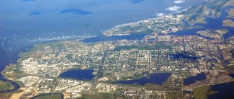
Sakhalin on the map of Russia shows the ratio of its area to the total area of the Kuril Islands. The area of Sakhalin significantly exceeds the total area of the Kuril Islands. The regional center is the city of Yuzhno-Sakhalinsk.
Sakhalin regions:
- Alexandrovsk-Sakhalinsky;
- Anivsky;
- Dolinsky;
- Korsakovsky;
- Makarovsky;
- Nevelsky;
- Nogliki;
- Okhinsky;
- Poronaisky;
- Smirnykhovsky;
- Tomarinsky;
- Tymovsky;
- Uglegorsky;
- Kholmsky.
Kuril regions:
- Kurilsky;
- North Kuril;
- Yuzhno-Kurilsky.
The names of district centers correspond to the names of districts.
They want to make the celebration of the 75th anniversary of the Sakhalin region nationwide
17:40 June 10, 2021
Holidays, Yuzhno-Sakhalinsk
A public forum was held to discuss the 75th anniversary of the Sakhalin region. 2022 will be a milestone year for the island region. The concept of the festive events began to be actively discussed with social activists, volunteers and all concerned residents of the region.
First Deputy Governor Sergei Baidakov spoke at the forum in the regional center of folk art. He stressed that the celebration should become nationwide.
— This is not a holiday for the authorities, but for every resident of Sakhalin and the Kuril Islands. The governor called to appeal to the public, to collect as much as possible proposals, projects, ideas from people on how to spend the anniversary year. The most important thing is not the celebration itself, but the content. Firstly, the history of the formation and development of the Sakhalin region. More than two thousand Soviet soldiers gave their lives for the liberation of the islands. We must not forget about this. Secondly, the anniversary year gives a reason to think about the future, about projects that are designed to make life on the islands more comfortable,” said Sergei Baidakov.
In the anniversary year, it is planned to begin the implementation of major investment projects, increase the volume of housing construction, and launch a climate experiment to achieve carbon neutrality.
Project “Care. Protection. Respect" will significantly improve the quality of service delivery and bring interaction between authorities and residents to a new level.
— Sakhalin and the Kuril Islands are our home. We are all one family. And now we, like a real family, will gather and discuss the upcoming holiday. Who should you invite to visit, what gifts should you give? We are waiting for proposals from all residents of the region, young and old. The anniversary year should be full of interesting events both for little Sakhalin and Kuril residents, and for honored fellow countrymen,” said Vladimir Ikonnikov, Chairman of the Public Chamber of the Sakhalin Region.
In honor of the 75th anniversary of the Sakhalin region, it is proposed to hold three large events. For example, a family sports competition project is planned. The Labor Dynasties competition is designed to tell the stories of families in which several generations live and work for the benefit of the Sakhalin region. The Sakhalin Alleys project is also planned. It will perpetuate the names of 75 islanders who made a significant contribution to the development of the region in different periods of history.
Currently, a website is being developed dedicated to the 75th anniversary of the Sakhalin region, where all proposals from residents for the anniversary year will be collected and all relevant information will be posted, reports IA Sakh.com with reference to PSO.
IA Sakh.com
- 7222
- 38
- 4
- To favorites
- Send
- Error
- Share
- Link
Climate features in different parts of the island
Sakhalin on the map of Russian climatic zones is located in the monsoon climate region of temperate latitudes. However, the climate varies from region to region. This is due to its geographical position (meridional elongation and location between seas with different characteristics), proximity to a huge continent and relief.
The proximity to Eurasia explains the general monsoon climate of the island - the wind direction is north and north-west in winter, and south and south-east in summer. The elongation of the island explains the difference in the amount of heat received by its northern and southern regions - it is colder on the northern shores than in the south.
The cold East Sakhalin Current runs along the coast of the Sea of Okhotsk, while the coast of the Sea of Japan is influenced by the warm Tsushima Current. Mountain ranges change the movement of air masses and protect river valleys from the invasion of cold. A special feature of the island is its seasonal temperature shift. Here February is the coldest month, August is the warmest month.
The most comfortable area for summer tourism is the Susunai Valley of southern Sakhalin, which opens wide into Salmon Bay, located in the intermountain basin.
The valley has moderately cold, rather humid winters with an average January temperature of -8°C, humid, not very hot summers from +15 to + 20°C. Summer precipitation prevails in August; in winter, snow drifts reach 0.5 - 1.0 m. However, snow does not last everywhere, so skiers are better off choosing other areas.
The Tymovskaya Valley of central Sakhalin is the most frozen place, as it is located between mountain ranges that prevent the penetration of wet sea masses that soften the frosts. The average February temperature is -26°C, the minimum is -54°C. Summer is hot, sometimes the temperature rises to +30-38oC, but frosts are possible at times.
In addition to special areas, there are typical climatic characteristics of the entire island, as well as its north and south. Summers are humid and cool, fog and rain are common, but the northern regions warm up less.
Winter is snowy, with snowstorms. Snow avalanches occur in the mountains, in some places the snow depth reaches 8 m. In the north, winter conditions have been observed since the last days of October; in the south, winter comes a month and a half later.
The specificity of Sakhalin is typhoons coming from the expanses of the Pacific Ocean. In summer there are strong winds reaching hurricane speeds and heavy rains, with possible floods, landslides and mud flows, and destruction in populated areas. In winter there are snowstorms for several days, snow drifts up to 2 m, broken wires, disruption of transport.
Sakhalin region of the Russian Federation - 75 years
Sergey Ponomarev, January 1, 2022, 19:09 — REGNUM The Sakhalin region of the Russian Federation in its modern borders and status, the 75th anniversary of its formation is celebrated on January 2, 2022, is the fruit of our country’s victory in World War II, which ended with unconditional surrender on September 2 1945 of the last German ally - Japan. Russia regained southern Sakhalin and the Kuril Islands, ensured the safety of navigation in the Sea of Okhotsk and its Pacific coast as a whole, and our country acquired the modern configuration of its Far Eastern borders.
Flag of the Sakhalin region of Russia
The parents of this victory were the geopolitical security interests of the Soviet Union/Russia in northeast Asia, perfectly understood and pursued by the leader of the USSR I. Stalin, which then coincided with the interests of our allies - Great Britain and the USA, who had long sought to involve our country in the war with Japan. This coincidence of interests was formalized on February 11, 1945 at the Crimean (Yalta) Conference by an agreement between the leaders of the three powers - Stalin, Roosevelt and Churchill. Stalin was then the Supreme Commander-in-Chief, Chairman of the Council of People's Commissars of the USSR and leader of the ruling party - the All-Union Communist Party (Bolsheviks).
One of the conditions for the USSR to enter the war against Japan, which unleashed the Second World War in the east by attacking China in 1937 and then the USA and Great Britain in 1941, was the return of southern Sakhalin, lost to Russia in 1905, and the transfer (essentially - also the return) of the Kuril Islands, transferred in parts to Japan under the treaties of 1855 and 1875 in exchange for the removal of claims to the island of Sakhalin.
Having violated these treaties by attacking the Russian Empire at the beginning of the 20th century, Japan remained the owner of the Kuril Archipelago, but lost the legal basis for its possession.
On August 9, 1945, our country entered the war with Japan and liberated southern Sakhalin and the Kuril Islands as a result of the Yuzhno-Sakhalin offensive and Kuril landing operations. By decree of the Presidium of the Supreme Soviet of the USSR dated September 2, 1945, September 3 was established as a day of national celebration - Victory Day over Japan. More than 1.8 million people were awarded the medal “For Victory over Japan”.
Kuril landing operation (August 18 - September 1, 1945)
Without this necessary historical preamble, the formation of the modern Sakhalin region is not very clear.
In pursuance of the Yalta Agreement, the Supreme Commander of the Allied occupation forces in Japan, General MacArthur, on January 29, 1946, with his memorandum to the Japanese government, excluded southern Sakhalin and the Kuril Islands from Japanese jurisdiction. Immediately, on February 2, 1946, the Soviet Union established the Yuzhno-Sakhalin Region of the Khabarovsk Territory of the RSFSR on the liberated lands.
This administrative-territorial entity was of a temporary, transitional nature; its establishment was a demonstration of the solidity of the intentions of the Soviet Union to integrate the acquired territories into its composition.
The Russian population that survived the Japanese occupation of 1905-1945 in southern Sakhalin was about 300 people. Soviet citizens in these territories in 1946 were a few specialists - managers of various profiles who arrived in the direction of sectoral ministries, and mostly - soldiers-liberators of units of the Second Far Eastern Front, transformed into the Far Eastern Military District (FMD) with headquarters in Toyohara (until 1905, the Russian village of Vladimirovka). The commander of the Far Eastern District is Army General Purkaev. A street is now named after him in Yuzhno-Sakhalinsk, and a cape on the Kuril Island of Urup. The bulk of the civilian population of the Yuzhno-Sakhalin region consisted of foreigners - Japanese and Koreans, transported for hard work from occupied Korea. As of September 1945, 358.5 thousand Japanese and 23.5 thousand Koreans lived in southern Sakhalin. About 17 thousand Japanese lived in the Kuril Islands. Until mid-February 1946, the Japanese yen was the means of payment.
Only from February 1946 was Soviet legislation fully applied, an 8-hour working day was introduced for Japanese citizens, the right to work and rest, free medical care and education were secured, and nationalization began.
A peculiarity of the South Sakhalin region was the absence of constitutional authorities - local Councils of Workers' Deputies and their executive committees. The management was of a military-administrative nature. The civil administration of southern Sakhalin existed as a division of the Far Eastern Military District, headed by Colonel D. Kryukov, former deputy chairman of the Khabarovsk Regional Executive Committee. A street in Yuzhno-Sakhalinsk was named in his honor.
It was he, with the support of the command of the Far Eastern Military District and Deputy Chairman of the Council of Ministers of the USSR A.I. Mikoyan, who initiated the formation of the new Sakhalin region and its separation from the Khabarovsk Territory. Mikoyan had a good grasp of the state of affairs as curator of Sakhalin and Kamchatka since 1928. On behalf of Stalin, in the fall of 1945, he visited Sakhalin, the Kuril Islands, Kamchatka, and made a number of important management decisions here (on the exchange rate of the ruble to the yen, on the food supply of the Japanese population, on the placement of personnel, on the deployment of military units, etc.). Cipher telegram from D. Kryukov and. M. Purkaev’s request for the unification of small regions of the Khabarovsk Territory and the need to improve their status, directed, bypassing the Khabarovsk Regional Committee of the All-Union Communist Party (Bolsheviks), directly to I. Stalin, was satisfied.
Meeting of the Sakhalin Regional Committee, in the center at the table - Dmitry Kryukov
The Resolution of the Presidium of the Supreme Council of the RSFSR “On the liquidation of the Yuzhno-Sakhalin Region and the inclusion of its territory into the Sakhalin Region” was adopted literally “under the Christmas tree” on December 31, 1946, signed by the Chairman of the Presidium I. Vlasov and Secretary P. Bakhmurov and sent for approval to Supreme Soviet of the USSR.
Just two days later - January 2, 1947 - the Decree of the Presidium of the Supreme Council (PVS) of the USSR was adopted, which read: “ To approve the proposal of the Presidium of the Supreme Council of the RSFSR on the liquidation of the Yuzhno-Sakhalin region and the inclusion of its territory in the Sakhalin region. Separate the Sakhalin region from the Khabarovsk Territory ."
The decree was signed by the Chairman of the Presidium of the Supreme Soviet of the USSR N. Shvernik and the Secretary of the PVS A. Gorkin. It was agreed upon by the Chairman of the Council of Ministers of the USSR I. Stalin, and the Administrator of the Council of Ministers of the USSR Y. Chadayev.
Intensive state building in the Soviet Union was not interrupted by the holidays. The country's leadership worked on its own and did not give officials, supported by the productive classes, the opportunity to rest for 10-12 days on a dependent basis, while maintaining a monthly salary, as we are seeing now.
On February 25, 1947, the Supreme Soviet of the USSR adopted a law amending the Constitution of the USSR. Thus, in Article 22 of the Constitution of the USSR, which listed all the territories, regions and autonomous regions of the RSFSR, the Sakhalin region of direct republican subordination within its modern borders appeared for the first time, and the Yuzhno-Sakhalin (1946−1947) and Sakhalin regions of the Khabarovsk Territory of the RSFSR (1938 - 1947) , limited only to Northern Sakhalin, ceased to exist, transferring part of their name to the new region.
Since that time, the Sakhalin region has not been part of other administrative-territorial entities of Russia. Corresponding changes were made to the Constitution of the RSFSR in 1948. By eliminating one region, but actually leaving a regional center on its territory, by uniting territories, removing them from subordination to the Khabarovsk Territory and raising the administrative status to a constitutionally enshrined one, a new region was formed - the Sakhalin Region of the RSFSR ( now - the Russian Federation ).
The unification of the Yuzhno-Sakhalin (formed on February 2, 1946) and (North) Sakhalin (formed on October 20, 1932) regions of the Khabarovsk Territory of the RSFSR was logical from the point of view of economics, demography, defense and optimal management. In the south of the island there was a more developed industry and the bulk of the population lived. Since 1945, the headquarters of the Far Eastern Military District has been located here. By the Decree of the Presidium of the Supreme Soviet of the USSR dated April 18, 1947, the center of the region was moved from Aleksandrovsk to Yuzhno-Sakhalinsk. There were no convenient harbors in the north of the island, and in the south of Sakhalin there were three ports with longer navigation times (than Aleksandrovsky). They provided sea communication with the mainland and the Kuril Islands.
Plot st. Lenin, where the mayor's office of Yuzhno-Sakhalinsk is now located. 1948
The Khabarovsk Territory then included seven regions, three national districts, and four separate districts, so funding for the two Sakhalin regions was carried out on a residual basis. The new region's access to direct republican funding under the conditions of a centralized budget system accelerated and increased the ability to resolve local issues. The leadership of the Khabarovsk Territory did not know the specifics of the tasks being solved here, which were not typical for other subordinate territories.
These tasks consisted of replacing the Japanese capitalist model of economic management with the Soviet economic system, establishing the missing constitutional local authorities and eliminating extraordinary authorities, while simultaneously repopulating the region and repatriating the Japanese population. The formation of the united region accelerated the integration of the annexed territory into the Soviet Union and contributed to the acceleration of its development.
On April 1, 1947, the Yuzhno-Sakhalin Regional Department for Civil Affairs (a department of the Far Eastern Military District) was abolished, replaced by departments under the regional executive committee of the Sakhalin Regional Council of Workers' Deputies.
In accordance with the Resolution of the Presidium of the Supreme Council of the RSFSR of February 15, 1947 “On the formation of district and city Councils of Workers’ Deputies on the territory of Southern Sakhalin and the Kuril Islands,” the Sakhalin Regional Executive Committee, by decision No. 139 of April 22, 1947, formed executive committees of district and city Councils on territory of the former South Sakhalin region.
The first Sakhalin regional party conference, which preceded elections to local bodies of Soviet power, was held in October 1947. In December 1947, elections were held in the new region in rural (107), settlement (25), district (19), city (8 and 11 city district subordination) Councils and regional Council of Workers' Deputies. D.N. was elected chairman of the executive committee of the Sakhalin Regional Council of Workers' Deputies in December 1947. Kryukov.
Among some people concerned with the search for their either noble or convict-Sakhalin roots, there is a widespread misconception that in fact the date of formation of the Sakhalin region should be considered June 17, 1909, when the Sakhalin region of the Amur Governorate General (Amur Region) of the Russian Federation was formed in northern Sakhalin empires.
At the same time, they omit the full title of the region, and stick out the words “Sakhalin Region”. People identify (and confuse) a phenomenon and part of its name. In simplification lies a methodological error. We are not celebrating the anniversary of words, but the anniversary of a specific area!
A region is an administrative-territorial unit of a state, usually including a complex of government institutions in a certain territory. The formation of the Sakhalin region of the Amur Governorate General of the Russian Empire in the northern half of Sakhalin in 1909 is a historical fact, but not at all a reason for celebration. This is a fact of the downward trend of statehood in this territory.
House of the Governor General of the Amur Region in Khabarovsk
There are many other, more important memorable dates in the history of Sakhalin Island. Here are some examples:
On May 14, 1805, the Russian round-the-world expedition of Krusenstern landed on Sakhalin in Aniva Bay. The Sakhalin branch of the Russian Geographical Society proposes to install a memorial sign at the landing site, and the new administration of the municipality reacted positively to this proposal.
On September 22, 1853, Captain 1st Rank Nevelskoy, in the territory of the present city of Korsakov, announced to the local Ainu and Japanese, who organized summer fishing here, that Sakhalin belonged to the Russian Empire.
On April 25 (May 7 - current style), 1875, the St. Petersburg Treaty was concluded on the renunciation of Japan's claims to Sakhalin Island in exchange for the northern part of the Kuril Islands.
On May 15, 1884, the All-Russian Emperor approved the Regulations on the management of Sakhalin Island. For the first time, the position of the head of the island is introduced, the island is removed from the Primorsky region and directly enters the newly formed Priamur Governor-General as an independent administrative unit. Management of the island begins directly from Sakhalin. There is a sharp increase in the Russian population and the number of settlements. In 1897 there were already 130 of them. The population of Sakhalin at the beginning of the 20th century was more than 40 thousand people.
The tragic date is June 24, 1905. Enemy landing in the area of the current settlement of Prigorodnoye (Korsakov area) and the beginning of the first occupation of Sakhalin by Japan.
August 23 (September 5 - current style) 1905 - Treaty of Portsmouth, according to which Russia ceded the southern half of Sakhalin to Japan, and Japan withdrew troops from the northern part of the island.
Therefore, it is somehow impossible to rejoice at the fact that in 1909 the phrase “Sakhalin Region” appeared, hiding the reduction of the administrative unit in territory - by half, and in terms of population - partly fled, and partly forcibly removed by the occupiers - decreased five times (to 8 thousand people in 1908).
The administrative center of this so-called “Sakhalin”, but in fact semi-Sakhalin region was soon moved from Sakhalin to the mainland in Nikolaevsk-on-Amur, and then it finally died under the second Japanese occupation of 1920-1925.
It should be recognized that there is no state-legal continuity between the Sakhalin region of the Amur Governor-General of the Russian Empire in 1909 and the Sakhalin region of the RSFSR/USSR in 1947, despite the partial commonality of the territory.
Toyohara airfield (now Yuzhno-Sakhalinsk), 1946
Only after the withdrawal of Japanese troops from northern Sakhalin in May 1925 did it become possible to form here first the Sakhalin District (1925) and then, with the development of the economy and population growth, the new Sakhalin (geographically - North Sakhalin) region (1932) as part of the Far Eastern (later - 1938 - Khabarovsk) region.
We can agree with those who believe that the current name of the region as “Sakhalin” does not take into account the presence in its composition of the Kuril subregion, which has geostrategic significance, and therefore proposes to rename the Sakhalin region of the Russian Federation to the Sakhalin-Kuril region.
On the territory of the Sakhalin region there are memorial sites and monuments in honor of the head of the Amur Expedition G. Nevelsky, who carried out the order to annex Sakhalin to the Russian Empire, there is a monument to Marshal of the Soviet Union A. Vasilevsky, the commander-in-chief in the liberation of Sakhalin and the Kuril Islands from the Japanese militarists. It would be logical to erect a monument to allied agreement in the return of Sakhalin and the Kuril Islands to Russia.
At one time, the famous sculptor Z. Tsereteli agreed to erect a monument to the Yalta “troika” (Stalin, Roosevelt and Churchill) in Yuzhno-Sakhalinsk. They would look good facing south, simply titled "Border Guards". For starters, it was possible to put up a memorial sign in honor of the Yalta Conference. As far as we know, such a sound idea was proposed by the Russian Foreign Ministry representative office in Yuzhno-Sakhalinsk.
Without waiting for the next anniversary of the Sakhalin region, Victory Day over Japan should be returned to the all-Russian calendar.
But this is not a matter of one day, and today we should congratulate the residents of Sakhalin and Kuril Islands on a wonderful date - the 75th anniversary of the Sakhalin region of Russia in its modern borders and the status of a full subject of the Russian Federation.
Happy holiday, dear fellow countrymen!
Inland waters
Sakhalin on the map of Russia is a region with a dense river network. However, most rivers are small rivers, mostly mountainous. There are only two rivers on the island more than 300 km long, and several more 120-130 km long.
There are more than 16 thousand lakes on the island.
The largest ones are of the lagoon type. Small lakes are represented by oxbow lakes, thermokarst and dammed lakes in mountainous areas.
Neva Lake on Sakhalin
| Rivers | Lakes |
| Poronai | Nevskoe |
| Tym | Tunaicha |
| Lutoga | Besse |
| Langeri | Ayinskoe |
| Rukutama |
Of these, the first 4 rivers flow into various bays of the Sea of Okhotsk, the last one into Lake Nevskoye.
Features of the flora and fauna of Sakhalin
Due to the peculiarities of the Sakhalin climate, the flora of the island requires separate consideration for each climatic region.
For the northern part, where plains and many wetlands predominate, mosses and lichens are ubiquitous. In rare meadows there are forbs and sedges. Taiga massifs consist mainly of larches and cedars. To the south, spruce and fir trees appear; dwarf cedar dominates the mountain slopes.
The most interesting is the flora of southern Sakhalin. Northern taiga and southern species coexist here. Spruce and larches are entwined with vines of wild grapes and lemongrass. Hydrangea and rhododendron shrubs among yews and yellow maples.
The dwarf cedar grows next to the cork tree, mountain sakura and weigela. The hollies are surrounded by ferns. In the undergrowth there are often impenetrable thickets of Kuril bamboo. In the river valleys, willows and alders common to the middle zone are common, and oaks and ash trees are also found. The fauna of Sakhalin is not rich.
These are mainly taiga representatives:
- Brown bear;
- wolverine;
- fox;
- white hare;
- squirrel;
- chipmunk;
- ermine;
- weasel.
There are still wild reindeer in the north. There are many birds on Sakhalin; some stop here to rest on their way if they fly from afar. Indigenous species are common to the taiga and forests of Russia. On some secluded lakes, white swans breed their chicks in the summer. In the forests of southern Sakhalin there are birds and butterflies characteristic of the more southern region - the island of Hokkaido.
The world's largest fur seal rookery is registered on Tyuleniy Island.
Geographical location, objects, areas, natural conditions
An online map with borders shows that the Sakhalin region is a unique region, as it is located on islands that are separated from the mainland by the Strait of Tartary.
In the east there are high mountains with a highest point of 1609 meters, in the west there are slightly lower mountains, and in the south there are ridges with plains between them. The largest among them is considered to be North Sakhalin, separated from other regions by ridges and hills. A satellite map of the region allows you to see the state border of the country. From the south there is a border with Japan through the straits and by land. The border with the Khabarovsk and Kamchatka territories runs along the sea.
The extended region covers territories of different climatic zones - from temperate continental to arctic. A milder and more favorable climate is in the south of the region. In the northern part, it is unfavorable for life and agriculture due to harsh climatic conditions: snowfall, fog, strong winds, low winter temperatures - up to -45 degrees. The climate on the Kuril Islands is constantly influenced by the Sea of Okhotsk, which brings precipitation, cold and wind. In the west, living is more favorable, since the territory is located in a warm-temperate climate zone. The eastern part is unfavorable for living and developing agriculture, but in the center of the region the climate creates conditions for comfortable living and cultivation of agricultural land.
Minerals
The island's mineral resources are very diverse. The main one is oil and gas deposits. Thanks to this, Sakhalin hosts a unique gas liquefaction facility, which, along with oil, is successfully exported.
High quality hard coal is actively mined and used locally. Deposits of gold and germanium are important. Currently, a rich deposit of chromite ores has been discovered. Large-scale construction is underway on Sakhalin, so the extraction of limestone for cement production is also a priority.
In addition, there are many small ore occurrences of non-ferrous metals, but they have not yet been developed. The region is characterized by valuable mineralized and hot underground waters, since the island is located in the Pacific “Ring of Fire” zone.
Economy
The Sakhalin region belongs to the category of Russian regions that combine the richest resource and raw material potential with extreme conditions for its development. Insufficient staffing and poor infrastructure development of the territory, typical for the regions of this group, on Sakhalin are aggravated by the island position of the region and the lack of stable year-round communications within the region itself. That is why Sakhalin is one of the problem regions with a difficult investment climate, the radical improvement of which requires significant funds and a long time.
The region has high natural resource potential, according to which it ranks 39th in Russia. In addition to the biological resources of the sea, for which Sakhalin is in first place in Russia, the main resource is hydrocarbon fuel, which is most in demand by the economy. In terms of the volume of explored reserves of gas condensate, the Sakhalin region ranks 4th in Russia, 7th in gas reserves, 12th in coal reserves, 13th in oil reserves. The region ranks 26th in Russia in terms of timber reserves. However, in the Sakhalin region there is almost completely no significant range of ore mineral resources, hydropower resources, and reserves of non-metallic minerals are insignificant, which generally reduces the overall resource potential of the region.
Attractions
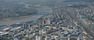
Sakhalin on the map of Russia is located far from major cities, and this is a good reason for an excursion route. There are interesting places in Yuzhno-Sakhalinsk that are accessible to visit, as they are located in the central part of the city. You can get there by city buses.
Sports and Tourist Complex "Mountain Air"
From a special platform on Mount Bolshevik you can see the city and the hills surrounding it. You can walk or take the cable car up.
It operates all year round and begins on Victory Square. At night, the complex glows with illuminated lights.
Bear Museum
The museum contains exhibits characterizing the life and culture of the 18th-21st centuries. Attention is drawn to numerous toys in the form of bears, as well as products from famous Russian creative centers.
Workshops of various types, a garden with live butterflies, and a planetarium are available to visitors. The museum is located on the 6th floor of the City Mall. You can get there by bus from any area of the city, including the airport and train station.
Memorial to Soviet soldiers
Memorial to the memory of soldiers who died during the battles of 1945 on the territory of Sakhalin and the Kuril Islands. This is an extensive complex with military equipment, sculptures, busts of Heroes of the USSR.
The dead are named on the wall of memory. The Eternal Flame burns in their honor. In 2022, the memorial's guns and tanks, which were damaged by bad weather, were restored. The complex is located on Glory Square in the city center.
Sakhalin Regional Museum of Local Lore
Located on Kommunistichesky Avenue in the building of the former Japanese Museum. On the territory of the museum complex there is a park with a fountain and interesting exhibits. Free admission. Internal exhibitions tell about the history and nature, the culture of indigenous peoples, and the modern development of the region. The paleontology department introduces organisms that inhabited the region millions of years ago.
Sakhalin Zoobotanical Park
The zoobotanical park occupies a vast area on Detskaya Street. True to its name, it is a botanical park with a zoo. Among the plants there are local wild plants, cultivated species, vines, herbs, and mushrooms.
The zoo contains mammals and birds, and it is interesting to visit the exatarium. At the petting zoo you can touch the animals. At the zoo you have the opportunity to see representatives listed in the Red Book.
Chekhov Peak
The Susunai mountains are not very high, only 2 peaks rise above 1 thousand m. These are the peaks of Pushkin and Chekhov. The height of Chekhov Peak is 1045 m, Pushkin Peak is slightly higher. Chekhov Peak is located near Yuzhno-Sakhalinsk. The climb is not the most difficult, but appropriate shoes are required. You can climb to the top along a path where dangerous areas are marked, ropes are stretched, and some stones are painted.
In some places there are plants and birds from the Red Book. Although this is a favorite vacation spot for many city residents, there are still areas of untouched landscapes. During the Japanese occupation of the island, a small temple was built on the highest platform, the remains of which are still visible.
When climbing to the top, you can get acquainted with plants typical of Sakhalin: dwarf cedar and Kuril bamboo, rhododendrons and dwarf birches. From the top a beautiful panorama opens up - hills, lakes, bays and Yuzhno-Sakhalinsk. From the city to the foot it is easy to reach by car or on foot from the Yuri Gagarin Park. You can purchase a 10-hour excursion from 9 a.m. to 7 p.m.
Cape Giant
The natural monument Cape Giant is a huge remnant of dense rock, ground by the wind over many thousands of years. But he is not the only one here; the entire coast up to Cape Ptichy looks like a museum of bizarre stone figures. The forest goes down almost to the water itself. Tourists can see bird colonies, seal rookeries, and the summer migration of pink salmon to spawn.
Fans of car trips should not rush to the shore in early spring, as part of the route passes along the coastal strip. The route is made more convenient by a bulldozer, which clears it at the start of the tourist season. If you wish, you can join the excursion, which lasts 10 hours and starts in Yuzhno-Sakhalinsk.
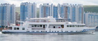
Korsakov sea trade port
The small town of Korsakov is located in Aniva Bay. Many berths, harbor cranes, and a clean area indicate the development and importance of the harbor. Tankers and dry cargo ships, small passenger ships and container ships are loaded here.
Cruise ships also arrive at the piers. The port provides connections between the island and the Kuril Islands and Japan. To see the panorama of the city and port, you can go up to the observation deck. The road to Korsakov does not take much time: about 1 hour by regular bus or train, less than 1 hour along the highway by private car.
The main lighthouse in Kholmsk
The small port city of Kholmsk is located on the southwestern coast of Sakhalin. There are 5 lighthouses in the city, some of them are Japanese, some are Soviet. The main lighthouse began operating in 1958.
It is a striped tower made of reinforced concrete, rising 67 m above sea level, although its height is 29 m. The lighthouse performs 2 tasks - it acts as a light and radio beacon. The light signal turns on every night, regardless of the time of year.
A regular bus leaves from Yuzhno-Sakhalinsk to Kholmsk every hour. By car you can drive along the highway in 1.5-2 hours. There is a dirt road from the city to the lighthouse, but it is not cleared in winter.
Yacht club "Vodnik" in the city of Kholmsk
The yacht club on Sovetskaya Street has existed since 1969, uniting children and adult lovers of sailboats. Club members participate in competitions and go on sailing trips. Children can receive professional training to work on yachts of various types.
Quiet Bay
In Quiet Bay the only noise is made by seagulls and waves rushing onto the shore. The bay is protected from the wind by wind-worn rocks. You can walk along the shore and look into the grottoes. Fishing, the underwater world, and the beauty of coastal plants also attract lovers. Fans of mountain walks can climb the Zhdanko ridge, look into the distance, at the sea, and take interesting photographs.
Tikhaya Bay received its name from Ivan Kruzenshtern, a famous Russian navigator, but in winter strong winds and snowstorms rage here. Therefore, a winter visit to the bay may only appeal to professional climbers and athletes. You can get here by car or by train from Yuzhno-Sakhalinsk station . The journey by train will take no more than 3 hours, the further journey is on foot.
Moneron Island
The island is located near the southwestern coast of Sakhalin and is a national natural marine park. This is a specially protected area with the possibility of educational tourism, so before your trip you need to familiarize yourself with the rules for visitors.
This is a small island, rising 440 m above the sea, an ancient, already collapsed volcano. The main advantage of the protected area is the unique combination of landscapes in a small area. The relative inaccessibility for most tourists makes the tasks of park staff easier.
Picturesque mountains, alpine meadows, gorges with steep walls, waterfalls, stone sculptures, small caves - all this can be seen on Moneron. A path made of boards has been laid especially for tourists, there are houses for those who come to the island, and routes to the main attractions have been developed.
Around the island in summer the sea is warm and the water is clear, so underwater photography here is especially successful. Of particular interest is the unique rookery of sea lions, to which a special route has been laid.
They can only get here by boat from the Nevelsk port, which is not always possible due to the weather. To be on the safe side, you can buy a 2-day tour from Yuzhno-Sakhalinsk. Then you will not need to worry about transport and excursions.
Rocks "Three Brothers"
In order to get to the rocks, you need to take the train in Yuzhno-Sakhalinsk, get to the Tymovskoye station, change there to a bus and get to the first capital of Sakhalin, Aleksandrovsk-Sakhalinsky.
Further - by taxi or on foot along the shore. If you decide to travel around the island in a personal car, you need to follow the highway. The final destination of the route is Cape Jonquiere. This is where the Three Brothers natural monument is located. These are three rocks, similar to each other, but different in size. Like brothers - eldest, middle, youngest. The picturesque group is placed on the coat of arms and flag of the city.
Fossil enthusiasts can add specimens of coal, ancient shells and plants to their collections.
On the shore you can see a lighthouse that has existed since the end of the 19th century, but is now dilapidated. Another interesting object is a tunnel through the rock, built at the same time for a horse-drawn railway.
It was never used because it was flooded at high tide, but it is still walkable. At the exit from the tunnel, another group of three rocks is visible - “Three Sisters”. They are smaller and less impressive than their “brothers”.
General information about the Sakhalin region
Distinctive features .
The only region in Russia entirely located on islands is the Sakhalin region. It includes the island of Sakhalin and the Kuril Islands. Perhaps this is, if not the most distant, then certainly the most inaccessible region of the Russian Federation. We learned about Sakhalin thanks to Russian pioneers who explored the shores of the Pacific Ocean in the 17th century. The Kuril Islands were discovered a little later - in 1711. Until the 19th century, no one laid claim to either the Kuril Islands or Sakhalin. The Ainu and Nivkhs lived there, who did not bother anyone, and were engaged in fishing and gathering. But over time, a struggle began between Russia and Japan for these islands, and questions about the ownership of the Kuril Islands are still periodically raised by the Japanese, who consider the four Kuril Islands to be their “northern territories.” What is the background to the conflict?
After the signing of the first border treaty between Russia and Japan in 1855, the island became the joint possession of the two states. In 1875, the countries “gave up”, and the southern part of Sakhalin passed to Russia, and Japan received all the Kuril Islands. In 1905, after Russia's defeat in the Russo-Japanese War, the southern part of Sakhalin officially passed to Japan. After the victory over Japan in 1945, the Soviet Union regained both Sakhalin and the Kuril Islands. Today Russia denies any possibility of changing the status of the Kuril Islands.
Geographical location . The Sakhalin region is located in the Far East and includes the islands of the Sea of Okhotsk - Sakhalin and the Kuril Islands archipelago. Therefore, it does not border any regions by land. By sea, its borders pass with the Kamchatka Territory in the north, the Khabarovsk Territory in the west, and with Japan in the south. The Sakhalin region is part of the Far Eastern Federal District.
Due to its large extent from north to south, the nature of the Sakhalin region is very diverse. If in the north of the Kuril Islands mostly shrubs grow, reminding us of the northern tundra, then in the south coniferous forests are already stretching with might and main, and the southern part of Sakhalin Island is also rich in deciduous forests. There are very few rivers; Sakhalin has several large rivers (Tum, Poronai, Lyutoga, Naiba).
Volcanoes of the Kuril Islands similar to giant waste heaps
Life on the islands has its own specifics. All of them are located in a seismically active zone. Therefore, there are many dangers for local residents. These include earthquakes and active volcanoes in the Kuril Islands. This includes tsunamis that can destroy entire cities. So, in 1952, a giant wave completely washed away Severo-Kurilsk, on the island of Paramushir. However, the city was rebuilt and people still live there.
Population. Although the Sakhalin region is located, from the point of view of a resident of the capital, almost at the end of the world, it is not such a sparsely populated region. In total, 493,302 people live here. Although in its best times, in 1990-1991, as many as 715 thousand people lived here.
80% of the population lives in cities. By national composition, 82% are Russians, 5% are Koreans, 2.44% are Ukrainians. Nivkhs make up only 0.44% of the region's population. The ratio of male to female population is 48% to 52%.
Residents of Yuzhno-Sakhalinsk have been accustomed to winter sports since childhood.
Crime . 29th place in the ranking of regions by the number of crimes committed. And this is not surprising. Harsh climate, drunkenness, corruption, unemployment - all this contributes to the development of crime.
The unemployment rate in Sakhalin is quite high - 7.66%. This corresponds to 60th place in the regional ranking. Needless to say, there are few businesses here. But in terms of domestic regional product per capita, the Sakhalin region is in third place.
Above are only Moscow (it’s clear why) and the Tyumen region (it’s also clear why - oil). The reasons for such success of the Sakhalin region are the oil, gas and gas condensate deposits found here. In terms of the volume of explored reserves of the latter, the Sakhalin region ranks 4th in the Russian Federation. On the Kuril Islands everything is much worse. In the southern Kuril Islands, people are mainly engaged in fish processing. Perhaps the joint exploitation of the southern islands with Japan, proposed by the Russian government, will somehow change the situation in the region.
The first gas power unit of the Yuzhno-Sakhalinskaya CHPP
The average monthly salary in the Sakhalin region is 39 thousand rubles. And the highest salaries are in the public administration sector (57 thousand rubles), financial activities (76 thousand rubles) and the extraction of fuel and energy minerals (64 thousand rubles). But this is not the case everywhere. For example, in various manufacturing industries the average salary is 13-14 thousand rubles.
Real estate value . Prices for apartments in the regional capital Yuzhno-Sakhalinsk are quite high: on average, a square meter here costs more than 70 thousand rubles. One-room apartments cost 2.7-3 million rubles. And these figures will only grow. But since salaries on Sakhalin are also decent, such housing is quite affordable for locals.
The climate of the Sakhalin region is influenced by the Sea of Okhotsk and the Kuril Current and is characterized by cold summers and severe frosty winters. The average temperature in February is −8°C, in August - from +10 to +17°C, depending on latitude. In summer there are frequent fogs, typhoons, and monsoon rains. The annual precipitation is 700-1000 mm.
Thermal springs
There are many thermal springs on Sakhalin, since the island is located in an area of active volcanoes. However, only 2 groups out of all are used.
- Daginsky springs located within the lagoon north of the village of Nogliki. During the Soviet era, a hospital was located here. Now only the Patriot spring has the appropriate design; the rest are hot puddles and pits with water. In summer, those wishing to take water or mud baths are accommodated in tents near the springs.
Supporters of organized treatment can purchase a ticket to the Dagi-Oasis sanatorium complex in the small village of Goryachiye Klyuchi. Those who are accustomed to life in hotels will be satisfied with a hotel room in the village of Nogliki. People get here by train from Yuzhno-Sakhalinsk, then by car along an asphalt road.
- Not far from Yuzhno-Sakhalinsk there are Sinegorsk springs. Their composition is unique because they contain arsenic. The sanatorium has a staff of highly qualified specialists to provide assistance to vacationers. The sanatorium is located in the village of Sanatornoye, which is easily accessible by bus or car from Yuzhno-Sakhalinsk.
Ski resorts
In winter, the capital of the island offers the following options for vacationers:
- The Mountain Air complex is located within the city of Yuzhno-Sakhalinsk. Comfortable accommodation, stable snow cover on several slopes, modern ski lifts, equipment rental.
- Winter resorts Tomari less known, but gradually developing. The trip to Tomari will take 4.5 hours by commuter train.
It is important for tourists to decide on travel dates in advance. Although Sakhalin does not look very expressive on the map of winter tourism in Russia, the winter months from the first days of December to the last days of April are suitable for skiers to relax. Sanatoriums operate regardless of the time of year. It is better to postpone sightseeing until the summer.
Article design: Mila Friedan
Historical reference
The Sakhalin region is located off the coast of the Eurasian continent in the transition zone from the continent to the Pacific Ocean. The distance from Yuzhno-Sakhalinsk to Moscow is 10,417 km. The region is separated from the capital of Russia by 7 time zones.
The Sakhalin region is a border region and the only subject of the Russian Federation entirely located on islands washed by the waters of the Sea of Okhotsk and the Sea of Japan and the Pacific Ocean. Its territory includes the islands of Sakhalin, Moneron, Tyuleniy and the Kuril archipelago, which includes the Big and Small island chain. The total area of the region is 87.1 thousand square meters. km.
Russia's exploration of Sakhalin and the Kuril Islands began in the mid-17th – early 18th centuries, with the campaigns of Russian explorers and sailors. Successful actions of the Amur expedition G.I. Nevelskoy (1849-1855) destroyed the theory of the “peninsular position” of Sakhalin and contributed to securing the region for Russia. Russian military posts and the first peasant villages were founded on the island. In 1869-1906, Sakhalin was the largest exile convict colony in Russia.
Foreign policy factors have traditionally had an important influence on the economic development of the region. From 1855 to 1945, in just 90 years, on the basis of the Russian-Japanese treaties: Shimoda (1855), St. Petersburg (1875) and Portsmouth (1905), the state border within Sakhalin and the Kuril Islands changed four times archipelago.
In 1884, Sakhalin was separated into an independent administrative unit. In 1909, the Sakhalin region was formed as part of the Amur Governor-General.
During the Civil War and foreign intervention, Japan occupied the Russian-owned northern part of Sakhalin in April 1920 and withdrew its troops from its territory only five years later. In May 1925, the Sakhalin District was formed within Northern Sakhalin, and from October 20, 1932, the Sakhalin Region was formed as part of the Far Eastern (from 1938 - Khabarovsk) Territory.
In 1945, as a result of victory in World War II, the USSR regained South Sakhalin and the Kuril Islands.
Within its modern borders, the Sakhalin region was formed on January 2, 1947 and became an independent region of the Russian Federation. The center of the region is the city of Yuzhno-Sakhalinsk, founded by Russian settlers in 1882.
According to the 2012 All-Russian Census, the population of the region is 495.4 thousand people. The largest cities are Yuzhno-Sakhalinsk, Kholmsk, Korsakov. More than 100 nationalities live in the region; 84.0 percent of them are Russians, 5.4 percent are Koreans, 4.0 percent are Ukrainians. The indigenous small peoples of the North are the Nivkhs, Evenks, and Oroks.