Description and location of the island
Sakhalin is located off the eastern coast of the Eurasian continent. Its area is 76.6 thousand km2. The island has an elongated shape in the north-south direction, about 950 km long.
From a geological point of view, Sakhalin is the northwestern part of the Pacific “Ring of Fire”, which also includes the Kuril Islands and the Japanese Islands. Island formations included in the “ring of fire” are characterized by earthquakes, often destructive, as well as volcanic eruptions. There are volcanoes on Sakhalin - mud volcanoes, not dangerous for people.
It is believed that the name of the island arose from the name of the Amur on an ancient map. The name "Sakhalyan-Ulla", belonging to the river and erroneously attributed to the island, was established thanks to later maps, where the island was called Sakhalin.
For residents of Japan, there is another name - Karafuto Island. The island is surrounded by the Seas of Okhotsk and Japan. Between the island and the mainland there are 2 straits - Tatarsky and Nevelsky.
The Nevelskoy Strait is narrow, less than 7.5 km wide, and is covered with ice in winter. The Sea of Okhotsk and the Sea of Japan are connected by the La Perouse Strait, which separates the Russian territory - Cape Krillon in the south of Sakhalin, from the northern Japanese island of Hokkaido. The strait is deep, on average 20-40 m, and wide (even at its narrowest part 43 km), which makes it convenient for navigation.
The relief of Sakhalin emphasizes its shape. Mountain ranges stretch along the coasts, with low-lying areas between them. The northern part of the island is low-lying, the southern part is predominantly mountainous with steep, rocky shores.
The coastline is indented, there are many small bays of round, elongated and bizarre shapes. Some bays are separated from the sea by coastal ledges or islands.
Perhaps a peninsula?
Sakhalin will be annexed to the mainland
The government approved a comprehensive plan for the development of main infrastructure
The existence of Sakhalin became known in the early 40s of the 17th century from Ataman Vasily Poyarkov, who with a small detachment reached the mouth of the Amur. True, he himself had not been to Sakhalin, but he heard from the local “Gilyaks” that there was a rich land beyond the sea where some “hairy people” lived, as they called the Ainu. Then his story was confirmed by Ivan Moskvin, who even compiled a certain description of Sakhalin from the words of local residents.
Around the same time, in 1643, the Dutch navigator Maarten De Vries, heading north on behalf of the Dutch East India Company from Indonesia in search of rich lands, landed in the very south of Sakhalin in Aniva Bay. On the frigate Castricum, he sailed several hundred miles along the east coast, not really understanding what kind of land it was - the Dutchman decided that it was a continuation of the island of Hokkaido. Formally, De Vries is considered the first European to set foot on Sakhalin soil, but this had no consequences - at that moment the Dutch were not interested in the northern territories, and soon they had no time for overseas travel.
Sakhalin_1
Ainu - representatives of the indigenous population of Sakhalin Island
Photo: RIA Novosti
Tikhaya Bay on Sakhalin is recognized as a legendary beach in Russia
The Russians also failed to develop their presence on Sakhalin, but for different reasons. At the end of the 40s of the same 17th century, following the pioneers Poyarkov and Moskvin, the Cossacks of Erofey Khabarov moved along the Amur, gradually developing new lands and imposing yasak (fur tribute) on the tribes of local hunters Daurs and Duchers. But in the area of the town of Albazin, they unexpectedly came across tribes that were already paying tribute to China. Naturally, a conflict arose; troops from Manchuria and China came to the aid of the Daurs. The war, now subsiding, now renewing, went on for 20 years, but in the end the Russians had to retreat. In 1689, the Treaty of Nerchinsk was signed, according to which Russia refused to move along the Amur River, recognizing the entire current Far East as Chinese territory. Including the lands in the area of the supposed mouth of the Amur, which has not yet been properly explored. Europe has almost forgotten about Sakhalin.
Only in 1739, a detachment of the Second Kamchatka Expedition of Vitus Bering, under the command of Lieutenant Alexei Shelting, approached from the sea and described the northeastern coast of Sakhalin, but did not have time to do the western and southern ones. In 1787, the French navigator Jean-François de La Perouse visited the coast of Sakhalin during a round-the-world expedition. He opened the strait between Hokkaido and Sakhalin and entered the waters that separated Sakhalin from the mainland. Having walked inland for some time (along the present-day Tatar Strait), he saw that the depth was becoming critical, and turned back, deciding that Sakhalin was a peninsula. Ten years later, the Englishman William Broughton explored the same waters between Sakhalin and the mainland and also came to the conclusion that there was no through strait. In the summer of 1805, these waters were explored by Ivan Krusenstern. He also entered the Tatar Strait and also could not reach its end, although he was ordered to explore the mouth of the Amur.
Sakhalin is getting closer
The President instructed to study the issue of building a bridge that will connect the island with the “mainland”
“Strong currents that I encountered in these places,” Kruzenshtern wrote in his report, “fears that further research would not incur the suspicion of the Chinese government and thereby damage Kyakhta trade, and, finally, fear that I would not collide with the Chinese force watching the mouth The Amur rivers, which they warned me about in Kamchatka, were the reasons that I did not exactly follow the instructions given to me.”
In justification for the famous captain, it is worth noting that he had no reason to doubt the accuracy of the conclusions of La Perouse and Broughton. In addition, “Nadezhda” had already been circumnavigating the world for two years, the crew was very tired, and it was unreasonable to expose the expedition to excessive risk thousands of kilometers from possible help. When the depths became critical, so as not to risk the ship, Kruzenshtern anchored and sent the boat ahead. However, she was unable to go further due to a very strong oncoming current, and the water in this place turned out to be fresh. This led the navigator to the idea that the mouth of the Amur was somewhere nearby, but there was no through navigable strait between Sakhalin and the mainland.
Sakhalin_1
Russian navigator Ivan Fedorovich Krusenstern
Photo: RIA Novosti
So, by the 40s of the 19th century, European geographical science was sure that Sakhalin was a peninsula. And if this is so, then according to the Nerchinsk Treaty it was included in the zone of Chinese influence. And officials of the Qing Empire supported this idea, assuring the Russian ambassadors that they were holding significant military forces at the mouth of the Amur. This is exactly what Krusenstern hinted at in his report.
The designer of the Crimean Bridge appreciated the idea of building a bridge to Sakhalin
The last attempt, dotting all the i’s, was made in 1846 by the Russian-American Company, but at the request of the government. The sailors of the brig “Konstantin” and its commander Alexander Gavrilov, when meeting with the Chinese, were ordered to refer to the irresistible wind and the breakdown of the ship, but to try to explore the mouth of the Amur not from the south (like all its predecessors), but from the north, from the Sea of Okhotsk.
Based on the results of the campaign, Chancellor Count Karl Nesselrode, in a report dated December 15, 1846, outlined the situation in a report to the emperor: “Your Majesty’s command was exactly fulfilled by the chairman of the main board of the Russian-American company, Baron Wrangel; mouth of the river The Amur turned out to be inaccessible to seaworthy vessels, because the depth on it is from 1 ½ to 3 ½ feet and the Sakhalin Peninsula; why R. The Amur has no meaning for Russia.”
On this report, Nicholas I wrote in his own hand: “I am very sorry. Leave the question of the Amur as a useless river; reward the persons sent to Amur.”
Far Eastern attraction
Vladimir Putin formulated tasks for the development of the region and proposed concluding a peace treaty with Japan by the end of the year
How to get to Sakhalin
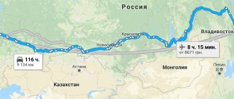
Sakhalin on the map of Russia gives an idea of the distance to it. The fastest way to get there is by plane. There are 2 options: fly to Yuzhno-Sakhalinsk or Vladivostok.
The most convenient way to get to the island is a non-stop flight from Moscow to Yuzhno-Sakhalinsk airport. The flight takes about 8.5 hours. Modern airliners are equipped with individual audio and video systems, and flight information is available to each passenger. Travelers are provided with hot meals, which are served twice. The time difference with Moscow is 8 hours.
If you were unable to purchase a ticket for a direct flight, you can fly to the international airport in Vladivostok, then by plane 2 hours to Yuzhno-Sakhalinsk.
Those wishing to see the country “from edge to edge” can be offered a train trip on the route Moscow – Vladivostok. There are 2 options: and the luxury tourist class “Imperial Russia”. The duration of the trip is at least 7 days. Then from Vladivostok in 2 hours by plane to Yuzhno-Sakhalinsk.
A more difficult option to get to Sakhalin is by ferry. The ferry service connects the mainland port of Vanino and the island port of Kholmsk. A regular bus runs between Kholmsk and Yuzhno-Sakhalinsk. You can get to Vanino by personal transport, but the road is of poor quality.
You can get to Vanino by train from Khabarovsk - 1 day, from Vladivostok - 2 days. The ferry journey takes about 12 hours. If desired, personal transport can be loaded onto the ferry by pre-booking a seat for it. There is a gas station in Kholmsk, the A-392 highway will lead to Yuzhno-Sakhalinsk in an hour.
Economy of Sakhalin
The region where Sakhalin is located is very rich in natural resources. The island's wealth includes offshore gas fields and marine biological reserves.
In addition, the Sakhalin region is the place where the Sakhalin-2 project is located, which was first discussed back in 1988. The project involved the development of two offshore fields, one of which contains mainly oil with associated gas, and the other, on the contrary, consists mainly of natural gas with a small oil content.
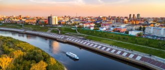
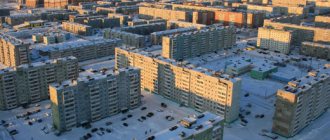
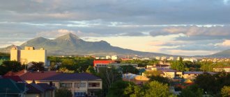
Southern Sakhalin, where the island's largest city and the region's capital is located, is the economic and transport center of the region. The entire population of the Sakhalin region does not exceed five hundred thousand people. The largest city in Sakhalin, where the airport and administrative offices are located, is Yuzhno-Sakhalinsk, which has a population of one hundred and ninety-four thousand people.
List of districts of the Sakhalin region with cities
Sakhalin on the map of Russia shows the ratio of its area to the total area of the Kuril Islands. The area of Sakhalin significantly exceeds the total area of the Kuril Islands. The regional center is the city of Yuzhno-Sakhalinsk.
Sakhalin regions:
- Alexandrovsk-Sakhalinsky;
- Anivsky;
- Dolinsky;
- Korsakovsky;
- Makarovsky;
- Nevelsky;
- Nogliki;
- Okhinsky;
- Poronaisky;
- Smirnykhovsky;
- Tomarinsky;
- Tymovsky;
- Uglegorsky;
- Kholmsky.
Kuril regions:
- Kurilsky;
- North Kuril;
- Yuzhno-Kurilsky.
The names of district centers correspond to the names of districts.
Climate features in different parts of the island
Sakhalin on the map of Russian climatic zones is located in the monsoon climate region of temperate latitudes. However, the climate varies from region to region. This is due to its geographical position (meridional elongation and location between seas with different characteristics), proximity to a huge continent and relief.
The proximity to Eurasia explains the general monsoon climate of the island - the wind direction is north and north-west in winter, and south and south-east in summer. The elongation of the island explains the difference in the amount of heat received by its northern and southern regions - it is colder on the northern shores than in the south.
The cold East Sakhalin Current runs along the coast of the Sea of Okhotsk, while the coast of the Sea of Japan is influenced by the warm Tsushima Current. Mountain ranges change the movement of air masses and protect river valleys from the invasion of cold. A special feature of the island is its seasonal temperature shift. Here February is the coldest month, August is the warmest month.
The most comfortable area for summer tourism is the Susunai Valley of southern Sakhalin, which opens wide into Salmon Bay, located in the intermountain basin.
The valley has moderately cold, rather humid winters with an average January temperature of -8°C, humid, not very hot summers from +15 to + 20°C. Summer precipitation prevails in August; in winter, snow drifts reach 0.5 - 1.0 m. However, snow does not last everywhere, so skiers are better off choosing other areas.
The Tymovskaya Valley of central Sakhalin is the most frozen place, as it is located between mountain ranges that prevent the penetration of wet sea masses that soften the frosts. The average February temperature is -26°C, the minimum is -54°C. Summer is hot, sometimes the temperature rises to +30-38oC, but frosts are possible at times.
In addition to special areas, there are typical climatic characteristics of the entire island, as well as its north and south. Summers are humid and cool, fog and rain are common, but the northern regions warm up less.
Winter is snowy, with snowstorms. Snow avalanches occur in the mountains, in some places the snow depth reaches 8 m. In the north, winter conditions have been observed since the last days of October; in the south, winter comes a month and a half later.
The specificity of Sakhalin is typhoons coming from the expanses of the Pacific Ocean. In summer there are strong winds reaching hurricane speeds and heavy rains, with possible floods, landslides and mud flows, and destruction in populated areas. In winter there are snowstorms for several days, snow drifts up to 2 m, broken wires, disruption of transport.
"Demoted to sailors"
Be yourself at the "Edge of the World"
Sakhalin International Film Festival answered the main questions
Having gone up the Amur in boats, Nevelskoy found several Manchus here, from whom he learned that the Chinese authorities forbid them to go down to the mouth and they illegally appear here for bribes in order to profitably buy furs. The Chinese do not have any military forces in the lower reaches of the Amur, and they are also terribly afraid that the navigability of the river will become known and large ships of foreigners - the British and the French - will descend there.
This radically changed the situation. Now the main competitor of the Russians was no longer the Chinese, but the Europeans, and the right of primacy in such matters became fundamental. Considering that after victory in the First Opium War (1840–1842), competitors received significant freedom of action, there was no time to hesitate. Therefore, in violation of the order, Nevelskoy decided to establish a post right at the mouth of the Amur, especially since he found a convenient place, which he named Nikolaevsky in honor of the current sovereign. On August 1, 1850, the Russian flag was solemnly raised over it under a gun salute. In each settlement of the Gilyaks (Nivkhs), Nevelskoy left a document in case foreigners appeared, declaring these lands Russian possession.
Sakhalin_1
Nivkh children. Sakhalin
Photo: Public domain
In the Nikolaevsky post on the Amur (a city of the same name will soon arise there, now Komsomolsk-on-Amur), there were six soldiers left with a falconet, who were ordered, after the river rose and the threat of foreigners had passed, to return to the Petrovskoye post - the “base” village expeditions in the Bay of Happiness. Dmitry Ivanovich Orlov, a naval officer, chief navigator in the Russian-American Company, a participant in Litke's circumnavigation, exiled to Siberia and deprived of ranks, rights and fortune, remained in charge of the winter quarters there. “He was a taciturn, unhurried man, small, lean, who suffered so many disasters and hardships that they were already powerless to cause him any harm. Orlov’s eyes shone with liveliness and energy...” Nevelskoy wrote about him.
Sakhalin_1
Korsakov is the first and oldest of the Russian settlements of Sakhalin
Photo: Getty Images/Universal History Archive/UIG
Sakhalin “Far Eastern hectares” will be united into a natural park
In the winter of 1851, Nevelskoy and Korsakov again went to St. Petersburg. This time, the captain’s arbitrariness caused not just anger, but a real storm - Chernyshev and Nesselrode, for direct violation of the order, demanded that he be deprived of his awards and demoted to sailor status. They suggested abandoning Nikolaevsk “out of harm’s way.” And again Nevelsky was saved by the intervention of the emperor, to whom Muravyov presented the situation in a favorable light. Nikolai called the captain’s action “valiant, noble and patriotic,” and on the report of the Special Committee he imposed a resolution that became famous: “Where the Russian flag has once been raised, it should not be lowered.”
Inland waters
Sakhalin on the map of Russia is a region with a dense river network. However, most rivers are small rivers, mostly mountainous. There are only two rivers on the island more than 300 km long, and several more 120-130 km long.
There are more than 16 thousand lakes on the island.
The largest ones are of the lagoon type. Small lakes are represented by oxbow lakes, thermokarst and dammed lakes in mountainous areas.
Neva Lake on Sakhalin
| Rivers | Lakes |
| Poronai | Nevskoe |
| Tym | Tunaicha |
| Lutoga | Besse |
| Langeri | Ayinskoe |
| Rukutama |
Of these, the first 4 rivers flow into various bays of the Sea of Okhotsk, the last one into Lake Nevskoye.
Ecology of the island
The Sakhalin region is exposed to significant environmental risks, since the extraction of hydrocarbons on the shelf is associated with certain technological difficulties.
In 2007, major international environmental organizations filed a lawsuit against the British government with the intention of obliging it not to provide a loan to a company engaged in offshore development on Sakhalin. This behavior was caused by the lack of necessary documentation and environmental assessment.
Features of the flora and fauna of Sakhalin
Due to the peculiarities of the Sakhalin climate, the flora of the island requires separate consideration for each climatic region.
For the northern part, where plains and many wetlands predominate, mosses and lichens are ubiquitous. In rare meadows there are forbs and sedges. Taiga massifs consist mainly of larches and cedars. To the south, spruce and fir trees appear; dwarf cedar dominates the mountain slopes.
The most interesting is the flora of southern Sakhalin. Northern taiga and southern species coexist here. Spruce and larches are entwined with vines of wild grapes and lemongrass. Hydrangea and rhododendron shrubs among yews and yellow maples.
The dwarf cedar grows next to the cork tree, mountain sakura and weigela. The hollies are surrounded by ferns. In the undergrowth there are often impenetrable thickets of Kuril bamboo. In the river valleys, willows and alders common to the middle zone are common, and oaks and ash trees are also found. The fauna of Sakhalin is not rich.
These are mainly taiga representatives:
- Brown bear;
- wolverine;
- fox;
- white hare;
- squirrel;
- chipmunk;
- ermine;
- weasel.
There are still wild reindeer in the north. There are many birds on Sakhalin; some stop here to rest on their way if they fly from afar. Indigenous species are common to the taiga and forests of Russia. On some secluded lakes, white swans breed their chicks in the summer. In the forests of southern Sakhalin there are birds and butterflies characteristic of the more southern region - the island of Hokkaido.
The world's largest fur seal rookery is registered on Tyuleniy Island.
Relief
The surface of the largest Russian island is entirely mountainous. These are mid-altitude mountains, low mountains and plains. The latter occupy only one quarter of Sakhalin. The north of the island is a hilly plain. While the western bank is a wide stone wall. On the east coast there is a frequent change of steep and flat land surfaces.
Mount Lopatina
There are 2 mountain systems on the island: West Sakhalin and East Sakhalin. The main peak is Mount Lopatina (1609 m). The above mountain systems are adjacent to the Tym-Poronayskaya lowland. The most popular tourist route leads to Mount Lopatina. The largest rivers of the island are Tym and Poronai, and among the lakes it is worth highlighting Sakhalin-Busse, Izmenchivoe, Tunaicha and Vavaiskoye.
Minerals
The island's mineral resources are very diverse. The main one is oil and gas deposits. Thanks to this, Sakhalin hosts a unique gas liquefaction facility, which, along with oil, is successfully exported.
High quality hard coal is actively mined and used locally. Deposits of gold and germanium are important. Currently, a rich deposit of chromite ores has been discovered. Large-scale construction is underway on Sakhalin, so the extraction of limestone for cement production is also a priority.
In addition, there are many small ore occurrences of non-ferrous metals, but they have not yet been developed. The region is characterized by valuable mineralized and hot underground waters, since the island is located in the Pacific “Ring of Fire” zone.
Natural resources
The severity of Sakhalin's climate is more than compensated by its wealth of resources. The most significant reserves here are coal and hydrocarbons. The region ranks 7th in the country in terms of gas volume, 12th in terms of coal volume, and 13th in oil volume.
In total, 35 valuable minerals are mined on the island. Local mineral resources are rich in mercury, gold, chromium, platinum and talc. Placer gold is mined directly on Sakhalin, which is an accumulation of rock fragments formed as a result of the destruction of deposits.
Attractions
Sakhalin on the map of Russia is located far from major cities, and this is a good reason for an excursion route. There are interesting places in Yuzhno-Sakhalinsk that are accessible to visit, as they are located in the central part of the city. You can get there by city buses.
Sports and Tourist Complex "Mountain Air"
From a special platform on Mount Bolshevik you can see the city and the hills surrounding it. You can walk or take the cable car up.
It operates all year round and begins on Victory Square. At night, the complex glows with illuminated lights.
Bear Museum
The museum contains exhibits characterizing the life and culture of the 18th-21st centuries. Attention is drawn to numerous toys in the form of bears, as well as products from famous Russian creative centers.
Workshops of various types, a garden with live butterflies, and a planetarium are available to visitors. The museum is located on the 6th floor of the City Mall. You can get there by bus from any area of the city, including the airport and train station.
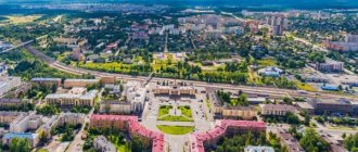
Memorial to Soviet soldiers
Memorial to the memory of soldiers who died during the battles of 1945 on the territory of Sakhalin and the Kuril Islands. This is an extensive complex with military equipment, sculptures, busts of Heroes of the USSR.
The dead are named on the wall of memory. The Eternal Flame burns in their honor. In 2022, the memorial's guns and tanks, which were damaged by bad weather, were restored. The complex is located on Glory Square in the city center.
Sakhalin Regional Museum of Local Lore
Located on Kommunistichesky Avenue in the building of the former Japanese Museum. On the territory of the museum complex there is a park with a fountain and interesting exhibits. Free admission. Internal exhibitions tell about the history and nature, the culture of indigenous peoples, and the modern development of the region. The paleontology department introduces organisms that inhabited the region millions of years ago.
Sakhalin Zoobotanical Park
The zoobotanical park occupies a vast area on Detskaya Street. True to its name, it is a botanical park with a zoo. Among the plants there are local wild plants, cultivated species, vines, herbs, and mushrooms.
The zoo contains mammals and birds, and it is interesting to visit the exatarium. At the petting zoo you can touch the animals. At the zoo you have the opportunity to see representatives listed in the Red Book.
Chekhov Peak
The Susunai mountains are not very high, only 2 peaks rise above 1 thousand m. These are the peaks of Pushkin and Chekhov. The height of Chekhov Peak is 1045 m, Pushkin Peak is slightly higher. Chekhov Peak is located near Yuzhno-Sakhalinsk. The climb is not the most difficult, but appropriate shoes are required. You can climb to the top along a path where dangerous areas are marked, ropes are stretched, and some stones are painted.
In some places there are plants and birds from the Red Book. Although this is a favorite vacation spot for many city residents, there are still areas of untouched landscapes. During the Japanese occupation of the island, a small temple was built on the highest platform, the remains of which are still visible.
When climbing to the top, you can get acquainted with plants typical of Sakhalin: dwarf cedar and Kuril bamboo, rhododendrons and dwarf birches. From the top a beautiful panorama opens up - hills, lakes, bays and Yuzhno-Sakhalinsk. From the city to the foot it is easy to reach by car or on foot from the Yuri Gagarin Park. You can purchase a 10-hour excursion from 9 a.m. to 7 p.m.
Cape Giant
The natural monument Cape Giant is a huge remnant of dense rock, ground by the wind over many thousands of years. But he is not the only one here; the entire coast up to Cape Ptichy looks like a museum of bizarre stone figures. The forest goes down almost to the water itself. Tourists can see bird colonies, seal rookeries, and the summer migration of pink salmon to spawn.
Fans of car trips should not rush to the shore in early spring, as part of the route passes along the coastal strip. The route is made more convenient by a bulldozer, which clears it at the start of the tourist season. If you wish, you can join the excursion, which lasts 10 hours and starts in Yuzhno-Sakhalinsk.
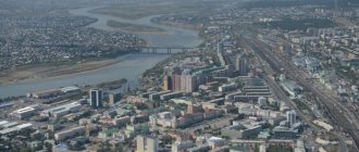
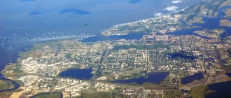
Korsakov sea trade port
The small town of Korsakov is located in Aniva Bay. Many berths, harbor cranes, and a clean area indicate the development and importance of the harbor. Tankers and dry cargo ships, small passenger ships and container ships are loaded here.
Cruise ships also arrive at the piers. The port provides connections between the island and the Kuril Islands and Japan. To see the panorama of the city and port, you can go up to the observation deck. The road to Korsakov does not take much time: about 1 hour by regular bus or train, less than 1 hour along the highway by private car.
The main lighthouse in Kholmsk
The small port city of Kholmsk is located on the southwestern coast of Sakhalin. There are 5 lighthouses in the city, some of them are Japanese, some are Soviet. The main lighthouse began operating in 1958.
It is a striped tower made of reinforced concrete, rising 67 m above sea level, although its height is 29 m. The lighthouse performs 2 tasks - it acts as a light and radio beacon. The light signal turns on every night, regardless of the time of year.
A regular bus leaves from Yuzhno-Sakhalinsk to Kholmsk every hour. By car you can drive along the highway in 1.5-2 hours. There is a dirt road from the city to the lighthouse, but it is not cleared in winter.
Yacht club "Vodnik" in the city of Kholmsk
The yacht club on Sovetskaya Street has existed since 1969, uniting children and adult lovers of sailboats. Club members participate in competitions and go on sailing trips. Children can receive professional training to work on yachts of various types.
Quiet Bay
In Quiet Bay the only noise is made by seagulls and waves rushing onto the shore. The bay is protected from the wind by wind-worn rocks. You can walk along the shore and look into the grottoes. Fishing, the underwater world, and the beauty of coastal plants also attract lovers. Fans of mountain walks can climb the Zhdanko ridge, look into the distance, at the sea, and take interesting photographs.
Tikhaya Bay received its name from Ivan Kruzenshtern, a famous Russian navigator, but in winter strong winds and snowstorms rage here. Therefore, a winter visit to the bay may only appeal to professional climbers and athletes. You can get here by car or by train from Yuzhno-Sakhalinsk station . The journey by train will take no more than 3 hours, the further journey is on foot.
Moneron Island
The island is located near the southwestern coast of Sakhalin and is a national natural marine park. This is a specially protected area with the possibility of educational tourism, so before your trip you need to familiarize yourself with the rules for visitors.
This is a small island, rising 440 m above the sea, an ancient, already collapsed volcano. The main advantage of the protected area is the unique combination of landscapes in a small area. The relative inaccessibility for most tourists makes the tasks of park staff easier.
Picturesque mountains, alpine meadows, gorges with steep walls, waterfalls, stone sculptures, small caves - all this can be seen on Moneron. A path made of boards has been laid especially for tourists, there are houses for those who come to the island, and routes to the main attractions have been developed.
Around the island in summer the sea is warm and the water is clear, so underwater photography here is especially successful. Of particular interest is the unique rookery of sea lions, to which a special route has been laid.
They can only get here by boat from the Nevelsk port, which is not always possible due to the weather. To be on the safe side, you can buy a 2-day tour from Yuzhno-Sakhalinsk. Then you will not need to worry about transport and excursions.
Rocks "Three Brothers"
In order to get to the rocks, you need to take the train in Yuzhno-Sakhalinsk, get to the Tymovskoye station, change there to a bus and get to the first capital of Sakhalin, Aleksandrovsk-Sakhalinsky.
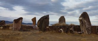
Further - by taxi or on foot along the shore. If you decide to travel around the island in a personal car, you need to follow the highway. The final destination of the route is Cape Jonquiere. This is where the Three Brothers natural monument is located. These are three rocks, similar to each other, but different in size. Like brothers - eldest, middle, youngest. The picturesque group is placed on the coat of arms and flag of the city.
Fossil enthusiasts can add specimens of coal, ancient shells and plants to their collections.
On the shore you can see a lighthouse that has existed since the end of the 19th century, but is now dilapidated. Another interesting object is a tunnel through the rock, built at the same time for a horse-drawn railway.
It was never used because it was flooded at high tide, but it is still walkable. At the exit from the tunnel, another group of three rocks is visible - “Three Sisters”. They are smaller and less impressive than their “brothers”.
Thermal springs
There are many thermal springs on Sakhalin, since the island is located in an area of active volcanoes. However, only 2 groups out of all are used.
- Daginsky springs located within the lagoon north of the village of Nogliki. During the Soviet era, a hospital was located here. Now only the Patriot spring has the appropriate design; the rest are hot puddles and pits with water. In summer, those wishing to take water or mud baths are accommodated in tents near the springs.
Supporters of organized treatment can purchase a ticket to the Dagi-Oasis sanatorium complex in the small village of Goryachiye Klyuchi. Those who are accustomed to life in hotels will be satisfied with a hotel room in the village of Nogliki. People get here by train from Yuzhno-Sakhalinsk, then by car along an asphalt road.
- Not far from Yuzhno-Sakhalinsk there are Sinegorsk springs. Their composition is unique because they contain arsenic. The sanatorium has a staff of highly qualified specialists to provide assistance to vacationers. The sanatorium is located in the village of Sanatornoye, which is easily accessible by bus or car from Yuzhno-Sakhalinsk.
Flora
Forests cover two-thirds of Sakhalin's territory. The lush vegetation of the island turns many of them into real jungles. The north of the island is a striking example of light-coniferous taiga, while dark-coniferous forests predominate in the south. As you go up, you can’t help but notice how the spruce-fir forests give way to holm birch trees.
Gmelin larch
The local flora includes more than 1000 plant species. The main tree of the island is Gmelin larch. Slightly less common are Ayan spruces, Sakhalin firs, yellow maples, Japanese elms and poplars. Only on Sakhalin can you see a coniferous forest surrounded by Sakhalin bamboo.
More than a hundred local plants are protected by the Red Book. These include tiger lily, Japanese sedge, sword iris, ailantholifolia, mountain peony, Wright's viburnum and many others. A unique feature of Sakhalin is the proximity of southern and northern plants. So, lemongrass can bloom here next to the spruce trees. Tropical vines are also found.
Ski resorts
In winter, the capital of the island offers the following options for vacationers:
- The Mountain Air complex is located within the city of Yuzhno-Sakhalinsk. Comfortable accommodation, stable snow cover on several slopes, modern ski lifts, equipment rental.
- Winter resorts Tomari less known, but gradually developing. The trip to Tomari will take 4.5 hours by commuter train.
It is important for tourists to decide on travel dates in advance. Although Sakhalin does not look very expressive on the map of winter tourism in Russia, the winter months from the first days of December to the last days of April are suitable for skiers to relax. Sanatoriums operate regardless of the time of year. It is better to postpone sightseeing until the summer.
Article design: Mila Friedan
Geographical position
Sakhalin is located in the Pacific Ocean. From the east it is washed by the Sea of Okhotsk, and from the west by the Sea of Japan. Sakhalin is separated from the island of Hokkaido by the La Perouse Strait, and from the mainland of Asia by the Strait of Tartary. Its narrowest section (7.3 m) is called the Nevelskoy Strait. An important milestone in the history of the island is associated with the named strait.
Until the mid-19th century, Sakhalin was considered a peninsula. But in 1849, Admiral Gennady Nevelsky discovered a space deep enough for ships to pass through. The open narrow strait was subsequently named after the admiral. However, Japanese researchers were the first to come to the conclusion that Sakhalin is not a peninsula. This happened at the beginning of the 19th century.