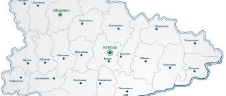
In the south-west of the Central part of Russia there is a small subject of the Russian Federation - the Lipetsk region. This is the smallest region in the Central Black Earth economic region of the country. Using a satellite map of the Lipetsk region, you can see that the following areas border the region:
- Ryazan;
- Voronezh;
- Kursk;
- Tambovskaya;
- Tula;
- Orlovskaya.
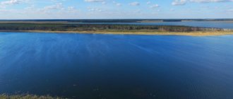
The region's territories are not very densely populated. This is explained by the fact that in the region a large amount of land is occupied by numerous rivers and reservoirs, most of which belong to the Don basin. The main rivers of the region can be seen on the map of the Lipetsk region by region:
- Voronezh;
- Matyra;
- Beautiful Mecha;
- Standing Cassock;
- Pine.
A number of rivers belong to the Volga basin and are located in the northeastern part of the region. The lands of the region are black earth. Since ancient times, the population living here has been engaged in arable farming and growing agricultural crops.
The formation of the region as a subject of the Russian Federation occurred in the middle of the last century, when several districts around the city of Lipetsk were united. Natural objects, industrial zones, streets, houses and districts on the map of the Lipetsk region can be studied by zooming in and moving around the online service using the mouse.
Districts of the Lipetsk region on the map
The entire territory of the region occupies about 25 thousand km2 and is divided into 18 districts. The largest districts in terms of population and area, which can be viewed using maps of the Lipetsk region with diagrams:
- Gryazinsky;
- Lebedyansky;
- Dobrinsky;
- Lipetsky.
The smallest in area, but densely populated district of the region is Khlevensky. It is located in the south of the region on the border with the Voronezh region. The district includes 16 villages, which, if you zoom in on the map of the Lipetsk region with villages, can be examined in more detail.
Railways and highways pass through the main district of the region - Lipetsk, and domestic air flights are also carried out from the airport, which is located in the suburbs. The direction of highways R-119, R-204, R-205, as well as other highways in the region can be viewed using a detailed road map of the Lipetsk region. It will also help you find the main road junctions, bridges, and bypass roads around cities.
Abolished, but not forgotten. 16 districts of the Lipetsk region that no longer exist
12:01, 07 January 2022
Society
68 years ago - January 6, 1954, by Decree of the Presidium of the Supreme Soviet of the USSR, the Lipetsk region was formed from the districts of four neighboring regions. And on April 26 of the same year, the Supreme Soviet of the USSR approved the creation of the Lipetsk region. The region was created from “scraps” of the Voronezh, Kursk, Ryazan and Oryol regions. Our region initially included 34 districts, 16 of which were abolished between 1956 and 1963. These disappeared, but not forgotten, areas will be discussed.
“Wedding in Berezovka” and a temple with frescoes by Vasnetsov
Photo from the archives of the State Directorate
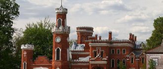
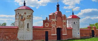
The Berezovsky district appeared in 1928 as part of the Kozlovsky district of the Central Black Earth Region. But after 2 years, its short life ended and it became part of the Dankovsky district. The revival of the Berezovsky region occurred in 1934 with the division of the Central Black Earth Region into Kursk and Voronezh. The “victim” for this was the renaming of the district to Oktyabrsky, and it itself became part of the Voronezh region. “Wedding in Berezovka” continued in 1937, when the area became part of the Ryazan region. After the war, the district returned its previous name, and in 1954 it became part of the Lipetsk region. After 5 years, the short, but full of transitions and renamings, history of the Berezovsky district ended with its abolition. Moreover, the territory for the second (!) time in 30 years went to the Dankovsky district. The administrative center of the former district, the village of Berezovka, still exists successfully today. The main and only “feature” of Berezovka was and remains the temple in honor of the martyr Dmitry Solunsky, built in 1891 in memory of the Russian soldiers who fell on the Kulikovo Field. It was built at his own expense by entrepreneur and philanthropist Yuri Nechaev-Maltsev. The design of the temple in the Russian style with “Moorish” columns was carried out by the architect Alexander Pomerantsev. There is information that Viktor Vasnetsov himself painted the temple. The metal structure of the roof, choirs and stairs were made according to the drawings of engineer Vladimir Shukhov, the “father” of the Shabolovskaya TV tower.
Unfortunately, the paintings and mosaics of the temple have not survived to this day, and the unique three-tented belfry was destroyed. Dmitrievskaya Church was abandoned until the beginning of the 21st century. Only in 2002, the temple was again transferred to the use of the Russian Orthodox Church MP, which in 2008-2009 installed a conservation roof made of metal corrugated sheets.
Photo by Vadim Razumov
In 2022, federal budget funds in the amount of 9.9 million rubles were allocated for the restoration of the temple, and two years later, more than sixteen million rubles were allocated by the Ministry of Culture of the Russian Federation.
Second Terbuny – what’s that like?
Over the course of its short 28-year history, Bolshe-Polyansky district even managed to change its administrative center. At first it was a village of the same name, and only later, as part of the Lipetsk region, Vtorye Terbuny became part of the Lipetsk region. The region was formed in 1928 and before being included in the Lipetsk region, it was successively part of the Central Black Earth, Voronezh and Kursk regions. As part of our region, the district existed for only 2 years and was abolished. Its territory became part of the Terbunsky district. The first “capital” - Bolshaya Polyana, is known as the birthplace of Kirill Kamynin - Hero of the Soviet Union, participant in the Great Patriotic War.
The Second Terbuny initially did without a numeral in their name, which was given after the small river Terbunka (from the Old Russian “terebeti” - to clear, to uproot).
In the Smolensk region, terebuns were called flax pullers, and since Terbuny was founded by service people from near Smolensk, they included one of the main types of their peasant craft in the name of the village. The first mention of Terbunov dates back to January 27, 1596 - in the scribe books of the Second Boxes.
In 1896, the Yelets – Kastornaya railway line ran 10 kilometers west of Terbunov. The station opened there was named Terbuny. A village of the same name grew up near the station. Now it is a local regional center. And for the sake of distinction, the old Terbuns began to be called the Second. By the way, in the 60s, the authorities tried to rename Vtorye Terbuny to Krasnoe, but ran into protest from local residents.
Abode of factories
The Borinsky district, as well as its Berezovsky brother, had two lives. From 1928 to 1933 it was called Borinsko-Zavodsky and was part of the Central Black Earth Region. In 1934, it was revived as part of the Voronezh region, 20 years later it ended up in the Lipetsk region, and only in 1963 was it abolished. The village of Borinskoye remains one of the most densely populated in the Lipetsk region - 6.5 thousand inhabitants. For example, 9 and 7 thousand people live in the regional centers of Dobrinka and Terbuny, respectively, and even less, 5 and 4 thousand people, in Dobroye and Volovo.
In Borinsky, which in Peter's time was noted for its water-powered iron smelting plant, which supplied products to the Voronezh shipyards (the name of the plant's builder is Borin), production still operates in our time. This is a sugar factory, founded back in 1864, and a mineral water bottling plant “Borinskie Vody”. The village has a developed infrastructure - in addition to regular bus service with Lipetsk, a kindergarten, a school and much more, it even has its own swimming pool.
And in Borinskoye, a prominent party figure, one of the organizers of the Komsomol, Pyotr Smorodin, was born, in whose honor one of the streets in Lipetsk is named.
"Hello" from Lithuania
The Volyn region, with its administrative center in the village of Lamskoye, existed from 1924 to 1963 and, before being accepted into the Lipetsk region, was alternately part of the Tula province, as well as the Central Black Earth, Kursk and Oryol regions. Now its territory belongs to the Stanovlyansky district. Shortly before its abolition, according to the results of the 1959 All-Union Population Census, 15,663 people lived in the Volyn region.
The village of Lamskoye, located on the right bank of the Semenek River, was named after the ravine of the same name. Toponymists believe that the toponym was transferred from the Baltic states; in Lithuanian the word loma means “lowland”. According to data from 1776, the village was a serf village and consisted of 56 households. Matvey Okorokov, Hero of the Soviet Union, tank driver, participant in the Battle of Kursk, was born in Lamskoye.
Photo from ru.wikipedia.org
Church of the Resurrection and monument to Voroshilov
In addition to the Lipetsk region, the Voskresensky district was part of the Voronezh and Ryazan regions and existed from 1934 to 1963. Further, its territory was divided between Dankovsky and Lebedyansky districts.
The former regional center - the village of Voskresenskoye, the first mention of which dates back to 1776, stands on the Dankov - Efremov highway at the intersection with the Ptan River. One and a half kilometers from the village there was previously the village of Dmitrievka, abolished in 1987. There are two attractions in Voskresensky - the Church of the Resurrection of Christ and the monument to Marshal Kliment Voroshilov.
Photo from ru.wikipedia.org
Village-planet
Grachevsky district was formed on December 31, 1934, when the Usmansky district was divided into the Voronezh region. With the formation of the Lipetsk region it was included in its composition. But already on July 4, 1956, the district was abolished, and its territory returned to the Usman district.
The village of Grachevka was founded in 1690 by settlers from the village of Novouglianka. Here the land was demarcated for them. The village received its name thanks to the Grachevsky Reach.
The village is named after the small planet “Grachevka”, discovered by the astronomer of the Crimean Astrophysical Observatory Nikolai Chernykh on September 24, 1976. The small planet received its name due to the fact that the father and mother of the discoverer were born in Grachevka.
All inclusive in Dmitryashevsky style
The Dmitryashevsky district lived a short life - from 1944 to 1956, having been part of the Voronezh and Lipetsk regions. Now its territory belongs to the Khleven district.
The history of the “capital” of the former region - the village of Dmitryashevka - will be richer. In the mid-18th century it was founded by people from Khlevnoy. The name of the village comes from the name of the first settler - Dimitry Rodionov. In 1811, a church was built here in honor of the Intercession of the Most Holy Theotokos; the parishioners numbered up to 2 thousand people. Since 1848, there was a parochial school at the temple.
Today, the village has its own hospital, as well as a fire department, a post office, a pharmacy, a kindergarten, a library, a rural cultural and leisure center, a secondary school and a correctional boarding school for children with disabilities.
Dmitryashevka is also rich in its numerous peasant farms, which specialize in growing grain crops and livestock products. There is also a large enterprise for the production of sunflower oil “Donskaya Niva”.
Romanov fiefdom
Photo from ru.wikipedia.org
Another abolished district of the Lipetsk region, which managed to change its regional center, was Donskoy. During its 35-year life - from 1928 to 1963, it, like some of its “colleagues”, managed to survive abolition and was reborn, was under the “yoke” of several regions until it became part of the Lipetsk region, and was also renamed. From 1934 to 1957, the Don region was called Vodopyanovsky - in honor of the hero of the Soviet Union, Mikhail Vodopyanov. On February 1, 1963, the district was abolished, and its territory was divided between the Lipetsk, Lebedyansky and Zadonsk districts.
The former regional center - the village of Donskoye, arose at the end of the 16th century as the possession of the Romanov boyars under the name Studenets. The name was given thanks to a tributary of the Don, the Studenets stream. Probably one of the first owners was the founder of the Romanov dynasty - Nikita Romanovich Zakharyin-Yuryev.
At the end of the 18th century, the village was already called Nizhny Studenets. Records have been preserved in the land survey plans of the Zadonsk district of the Voronezh province: “Studenets lower, Patriarchal identity, village of state-owned peasants, 710 male souls, convenient land 7259 dessiatines 740 sazhens, inconvenient land 298 dessiatines 1199 sazhens.” Thus, the area of the village was 82.46 square kilometers.
In parallel with the name Studenets/Nizhny Studenets, the village is also known as Patriarchye. The fact is that nearby, on the Yelets - Lipetsk railway line, there is a Patriarchal station. This is due to the fact that the village was owned by Fyodor Nikitich Romanov, better known as Patriarch Filaret, the son of Nikita Romanovich.
The cradle of Lipetsk history
The Kolybelsky district, like Dmitryashevsky, existed only from 1944 to 1956, and before joining the Lipetsk region, it belonged to the Ryazan region. And then the village councils distributed it between the Chaplyginsky and Dobrovsky districts.
The village of Kolybelskoye is known for the fact that its territory was inhabited by people in prehistoric times. This is evidenced by archaeological finds dating back to the Bronze Age: ceramics found in the vicinity of the village are examples of the Timber-frame culture (1400-900 BC), so named because of the burials in wooden log houses. People who lived in those distant times were engaged in agriculture and nomadic cattle breeding. In the 9th-12th centuries, this area was inhabited by Slavic tribes; this is also evidenced by archaeological finds on display at the local history museum.
After the Mongol-Tatar invasion of Rus', by the beginning of the 14th century, the future territory of the village, located on the northern outskirts of the Don region, was deserted due to the flight of the population forced to leave their homes. The re-population of the region began at the end of the 16th century in connection with the formation of a single state and the strengthening of the southern borders.
The oldest element in the settlement of the region was the Cossacks. Gathering in detachments, the Cossacks settled in hard-to-reach places on the southern outskirts, the so-called buffer zone between the Moscow state and the steppe. Because of this, they inevitably took part in border conflicts. They were the ones who founded Kolybelskoye.
After the defeat of the Polish-Swedish invaders in 1635, construction began on a fortified border line - the Belogorodskaya border line. Under its reliable shelter, intensive settlement of the region by service people began. In 1636, 615 people moved away from the fortified city of Kozlov, receiving estates in 18 villages and 3 settlements, including Kolybelskoye, which arose in the early 1640s. At the end of the 17th century, there were 55 households of service people in the village. At this time, a wooden temple was being built in the village in honor of Cosmas and Damian. Subsequently, after the southern border of Muscovite Rus' shifted to the south, large Moscow boyars, landowners and monasteries began to receive estates here. Thus, in the census books of 1646, the village is mentioned as Pochinok Kolybelsky, the property of one of the Moscow monasteries. The newly-minted patrimonial people settled new lands with their serfs, evicting them from different places of the Moscow state. The settlers brought with them distinctive features in clothing, conversation, construction of houses and housekeeping. In the second half of the 19th century, the village of Kolybelskoye became the center of the volost with a total of 14 villages and villages, in which there were 1,770 households, 8,906 people, and 10,681 acres of land.
The name of the village was given by the stream flowing from the “cradle” of the spring. This version is listed in toponymic reference books. There is also an opinion that the village is called so because at the end of the 16th - beginning of the 17th centuries, many of its residents skillfully made cradles for babies and sold them at the auctions that existed at that time.
In 1851, a brick church was built in Kolybelskoye on the site of an old wooden church, and after the abolition of serfdom and with the creation of zemstvo services, the situation in the field of public education and medical care improved. In 1871, a school for 40 students was opened in Kolybelskoye, and in 1884 a medical center with an annual budget of 4,271 rubles was opened. The good-quality, red-brick hospital building has survived to this day.
At the end of the 19th century, in the Kolybelsky volost there were 13 enterprises for processing agricultural products and 4 forges. In addition, various types of handicrafts were developed. The most common types of crafts are brick making, saddlery and basket weaving. At the turn of the 19th and 20th centuries, due to high population growth and a lack of allotment land, the largest number of families moved out of Kolybelskoye compared to other villages in Ranenburg district.
In our time, Kolybelskoye is famous for the feat of pilots Zakharov and Novoselov, who on April 21, 1987, at the cost of their lives, diverted a falling MiG-23UB plane not far from the village. A monument was erected at the site of their feat in the vicinity of Kolybelskoye. The pilots were posthumously awarded the Order of the Red Star.
Budyonny was here
The Oktyabrsky district existed from 1928 to 1963 and was part of the Central Black Earth, Voronezh and Lipetsk regions. And its name changed twice - from Dryazginsky, through Molotovsky and to Oktyabrsky. After its abolition, its territory was transferred to the Usman district.
The village of Oktyabrskoye, located on the banks of the Meshcherka River, arose at the beginning of the 18th century and was originally called Dryazgi. The village got its name from the word “squabbles” - brushwood, as well as sandy, liquid mud. Back in the 19th century, Dryazgi (not to be confused with the village of the same name on the Gryazi - Voronezh railway line) gained fame thanks to tobacco growing. In 1947, the village was renamed Molotovo, and ten years later - Oktyabrskoye.
Before the revolution, there were two schools in the village: the parish school and the zemstvo school. The Zemstvo school was built in 1905. There were 24 students, mostly boys. After the revolution, in the evenings at school the illiterate were taught to write and read. It was a four-year school. In 1935, a seven-year school was built opposite the former boarding school. In 1939, construction began on a new two-story school, which was completed after the end of World War II and accepted its first students in 1950.
During the civil war, the village was occupied by the Mamontovites. They destroyed an armored train at the Dryazgi station, captured commissars and Red Army soldiers, whom they shot in the field where the creamery is now located. After the liberation of Voronezh from the Mamontovites, units of the first cavalry army of Semyon Budyonny were in the village.
More than 600 village residents died on the fronts of the Great Patriotic War. During the war, there was a hospital on the territory of the village, located in a boarding school. Schoolchildren helped care for the wounded. They read books, staged concerts, and wrote letters at the request of the soldiers.
In 1942, two partisan detachments were created in the region. At the same time, Budyonny himself was in Dryazgi, holding a meeting with division commanders of partisan detachments in the building of the former RCP (b).
On the territory of Oktyabrsky there is a monument to the fallen pilots. On August 12, 1942, the remains of a burnt plane and pilots were discovered in the Telelyui forest.
In 1991, in the center of the village of Oktyabrskoye, opposite the Palace of Culture, a monument to fellow countrymen who died during the Great Patriotic War was erected.
Chamlyk rebels
The Talitsky district, with its administrative center in the village of Talitsky Chamlyk, was formed in 1938 as part of the Voronezh region and was abolished 18 years later when it was already in our region. Its territory was transferred to the Dobrinsky district.
Talitsky Chamlyk got its name thanks to the city of Talitsk and the Chamlyk River. In 1705, a group of servicemen from the city of Livny, and then in 1707 a larger group of Cossacks from the city of Talitsk, settled at the mouth of the Chamlyk and founded the Chamlyk settlement. In 1710, there were 70 households in the settlement with a total number of inhabitants of 257.
At the end of the 1720s, the Nikolsky and Kosmodemyansky churches were built in the settlement, which led to the formation of two independent settlements - Nikolskaya and Kosmodemyanskaya.
The Kolomna-Bakhmut postal route passed through the village. In 1837, a police officer’s apartment was opened here, and six years later, a rural school. In 1859, the village had 400 households with 2,917 residents. In 1872, a zemstvo hospital was built. In 1881, the stone temple of Cosmas and Damian was consecrated.
In 1914, 5481 residents lived in Talitsky Chamlyk. There were two zemstvo and parish schools, a zemstvo hospital, a pharmacy, a drug store, a credit partnership, the Vozdvizhenskaya fair and a market on Wednesdays.
Talitsky Chamlyk is known for its riots. Back in 1739, its residents supported the uprising of Dementy Zarubin. And during the final round of the Civil War - in February 1920, local peasants rebelled against the surplus appropriation system. On March 22, 1921, near the village, the 1st Antonov Army under the command of I. S. Kolesnikov entered into battle with the 14th separate cavalry brigade of the Red Army under the command of A. Milonov. Antonov's losses amounted to 800 wounded and killed. In addition, in 1931 there was a major anti-collective farm uprising in the village.
Talitsky Chamlyk is known as the birthplace of many famous and remarkable people, including Heroes of the Soviet Union and Socialist Labor.
Troekurovo - but not that
The Troekurovsky district, as well as many other heroes of this text, during its history - from 1928 to 1930, and from 1934 to 1963, was part of several regions. After its final abolition, its territory was transferred to the Chaplyginsky district.
The former regional center - the village of Troekurovo (not to be confused with the namesake from the Lebedyansky district, famous for its monastery) is located in the northwest of Chaplygin; it previously had its own railway station. Thanks to her, Troekurovo appeared - namely in 1898.
Before 1917, there were 30–40 houses in the village. Troekurovo became a local center for buying bread.
In 1998, the railway line to Lev Tolstoy station was dismantled as unnecessary and due to high maintenance costs. According to the General Plan of the Lev Tolstoy village, a highway will be built along it.
Trubetskoy Land
The Trubetchinsky district was part of the Central Chernozem, Voronezh, Ryazan and Lipetsk regions and existed in 1928-1930 and 1934-1963. In 1963, its territory was divided between Dobrovsky, Lebedyansky and Lipetsk districts.
The former administrative center is the village of Trubetchino, which arose in the second half of the 18th century on the patrimonial lands of Prince Trubetskoy. Since the end of the 18th century, the village belonged to the Vasilchikov princes. The last owner of the estate until 1918 was Countess Olga Tolstaya.
In documents from 1710, Trubetchino is mentioned as the village of Spasskoye, named after the wooden Spasskaya Church. Today there is a stone church of the Savior Not Made by Hands (Sergievskaya), built in 1830, which has the status of an architectural monument of regional significance.
In addition, Trubetchino is the birthplace of the famous architect Ivan Mashkov, who was born here in 1867.
“A worker and a peasant woman worked here, and Khvorostyanka developed...”
Another district that has lived two lives is Khvorostyansky. In the period from 1928 to 1933 and from 1934 to 1960, it was part of the Central Black Earth, Voronezh, Ryazan and Lipetsk regions. After its abolition in 1960, its territory was divided between the Gryazinsky and Dobrinsky districts.
The village of Khvorostyanka, which received its name - which is logical, thanks to brushwood - arose in the mid-18th century. Documents from 1782 mention the village of Khvorostyanka, the property of Peter Velyaminov. Then there were only 3 courtyards. Since 1820, when a church was built in Khvorostyanka, it became a village. In 1869, the Gryazi - Borisoglebsk railway line passed nearby, and the station was given the name Khvorostyanka.
In Khvorostyanka there was the estate of the pianist, one of the founders of the Voronezh branch of the Russian Musical Society, Andrian Mazaraki. Musicians and composers Rubinstein, Sakhnovsky and Dulov often came to the estate.
Outpost of the southern borders
The Chernavsky district, which was part of the Oryol and Lipetsk regions, existed in 1946-1960. Further, its territory was divided between Dolgorukovsky and Izmalkovsky districts.
It is known that already at the very beginning of the 11th century there was already a small fortress on the site of the future regional center - the village of Chernava. The settlement was considered a city and was called Chernavsky.
In 1668, the governor in Chernavsk was Semyon Fedorovich Grushetsky, a boyar and the father of Tsarina Agafya Grushetskaya, the first wife of Tsar Fyodor Alekseevich.
According to data from 1677, there were 5 (!) churches in Chernavsk: Dmitrievsky, Nikitsky, Nikolsky, Pokrovsky and Pyatnitsky.
In the middle of the 17th century, during the construction of the Belgorod Line, Chernavsk, finding itself deep in the rear, lost its military significance, but continued to be a city for several more decades. In 1779 Chernavsk was transformed into the village of Chernava.
In 1848, the Chernavsky paper-making factory was founded in Chernav by the partnership of Dmitry Rusanov. It was one of the large enterprises: in 1894 its capacity was 14 thousand pounds of writing paper per year. The most famous native of Chernava is undoubtedly St. Theophan the Recluse - one of the most revered Russian saints of the 19th century, bishop, theologian, publicist and preacher.
Thawed place
The Chibisovsky district, with its administrative center in the village of Talitsa, operated from 1935 to 1956. On July 4, 1956, it was abolished, and its territory was transferred to the Yeletsky district.
If we go back centuries, then in 1592, on the site of the present Talitsa, near the ford of the same name, a fort was built, which was part of the defensive zone of Yelets. There are two possible explanations for the name of the village: by the willow plant or by the non-freezing, thawed places on the Sosna River.
A village grew up near the fort, which was considered a city and was called Taletsk. In 1707, a large group from the city of Taletsk moved to a new place - at the mouth of the Chamlyk River and founded the village of Talitsky Chamlyk, which in the 20th century would also become a regional center.
Later the city lost its status and turned into a village. In Talitsa, a historical and architectural monument dating back to the end of the 17th century has been preserved - the stone Kazan Church. It was built in the center of a fortified fort. It was planned to use the temple walls as a refuge in case of attack. Until the mid-18th century, the temple was wooden, then it was rebuilt in stone - this is how it has been preserved to this day.
In the 1990s, the Talitsky church was renovated at the expense of parishioners, although without an attempt to restore the original decorative decoration.
Author - Maxim Boev
Subscribe to our channel in Yandex.Zen
Facebook Twitter
Map of the Lipetsk region with cities and villages
The settlements of the Lipetsk region are located close to each other. There are only 2 urban districts - Lipetsk and Yeletsky. Among the cities with a population exceeding 10 thousand people we can note:
- Usman;
- Lebedyan;
- Lipetsk;
- Chaplygin;
- Mud;
- Dankov.
They appeared on the site of former landowner settlements, therefore they have an interesting original history and architectural monuments confirming it. You can learn more about the infrastructure of a city or village, its streets, administrative institutions, and hospitals using a map of the Lipetsk region with settlements.
Attractions of the region are located throughout the territory. Here you can see natural monuments, architectural buildings, military-historical panoramas, ancient industrial and religious sites. Almost every settlement that is marked on the map of the Lipetsk region with cities and villages has its own “calling card”:
- Yelets - Ascension Cathedral of the mid-19th century;
- With. Polibino – hyperboloid mesh tower;
- Lipetsk - Novolipetsk Metallurgical Plant;
- With. Kon-Kolodez - the estate of the Senyavin landowners;
- With. Stanovoe is the largest arboretum in Russia;
- Zadonsk – three active ancient monasteries.
Of particular interest to travelers are the Galichya Mountain reserves, where you can see plants from the pre-glacial period.
CITIES OF LIPETSK REGION
| Population (estimated as of January 1, 2009), thousand people: Lipetsk region total population - 1163.3 men - 528.3 women - 635.0 Lipetsk total population - 502.5 men - 227.7 women - 274.8 Yelets total population - 111.2 men - 50.1 women - 61.1 Population density (as of January 1, 2009), people per 1 km2: Lipetsk region - 48.4 Lipetsk - 1567.1 Yelets - 1709.7 | Administrative-territorial division of the Lipetsk region as of January 1, 2009 Districts - 18 Cities - 8 Intra-city districts, city districts - 4 Cities (number of inhabitants - estimate as of January 1, 2009, thousand people): Lipetsk - 502.5 Elets - 111.2 Gryazi - 46.4 Dankov - 22.2 Lebedyan - 20.7 Usman - 19.4 Chaplygin - 13.2 Zadonsk - 10.5 Territory area, thousand km2: Lipetsk region - 24.0 Lipetsk - 0.321 Yelets - 0.065 |
GROUPING CITIES BY PERMANENT POPULATION1)
| Total | including the number of inhabitants, thousand people | ||||||||||
| until 3 | 3 — 4,9 | 5 — 9,9 | 10 -19,9 | 20 — 49,9 | 50 — 99,9 | 100 — 249,9 | 250 — 499,9 | 500 — 999,9 | 1 million or more | ||
| Number of cities | |||||||||||
| 2008 | 8 | — | — | — | 3 | 3 | — | 1 | — | 1 | — |
| 2009 | 8 | — | — | — | 3 | 3 | — | 1 | — | 1 | — |
| Population, people | |||||||||||
| 2008 | 747354 | — | — | — | 43002 | 89688 | — | 112188 | — | 502476 | — |
| 2009 | 746134 | — | — | — | 43061 | 89325 | — | 111213 | — | 502535 | — |
| __________ 1) Estimate as of January 1. | |||||||||||
DISTRIBUTION OF POPULATION OF LIPETSK AND CITIES WITH POPULATIONS OVER 100 thousand people BY AGE GROUPS 1
)(thousands of people)
| Lipetsk | Dace | |||
| 2008 | 2009 | 2008 | 2009 | |
| Whole population | 502,4 | 502,5 | 112,2 | 111,2 |
| including those aged: | ||||
| younger than able-bodied | 70,8 | 70,7 | 15,5 | 15,4 |
| of which children aged 1-6 years | 27,1 | 28,0 | 5,9 | 6,1 |
| able-bodied2) | 325,6 | 323,5 | 69,9 | 68,9 |
| older than able-bodied | 106,0 | 108,3 | 26,8 | 26,9 |
| __________ 1) Estimate as of January 1. 2) Men 16-59 years old, women 16-54 years old. | ||||
SHARE OF LIPETSK AND CITIES WITH A POPULATION OVER 100 thousand people IN THE MAIN SOCIO-ECONOMIC INDICATORS
OF THE LIPETSK REGION in 2008
(percent)
| Lipetsk | Dace | |
| Population (est. January 1, 2009) | 43,2 | 9,6 |
| Average annual number of employees of organizations1) | 52,4 | 10,9 |
| Availability of fixed assets of organizations 2) (at the end of the year) | 71,73) | 7,2 |
| Volume of shipped goods of own production, work and services performed in-house by type of activity1): | ||
| mining | 59,3 | 11,7 |
| manufacturing industries | 81,9 | 1,9 |
| production and distribution of electricity, gas and water | 80,9 | 9,0 |
| Scope of work performed for the type of activity “Construction”1) | 85,4 | 5,2 |
| Commissioning of the total area of residential buildings | 53,3 | 8,9 |
| Retail trade turnover1) | 85,8 | 3,3 |
| Investments in fixed capital1) | 62,2 | 2,7 |
| __________ 1) For organizations not related to small businesses. 2) At full book value; for commercial and non-profit organizations (excluding small businesses). 3) Including funds of OJSC Gazprom. | ||
SOCIO-ECONOMIC CHARACTERISTICS OF LIPETSK AND CITIES WITH POPULATIONS OVER 100 thousand people
| Lipetsk | Dace | |||
| 2007 | 2008 | 2007 | 2008 | |
| POPULATION | ||||
| Population (end of year estimate), thousand people | 502,4 | 502,5 | 112,2 | 111,2 |
| Number of births per 1000 population | 9,7 | 10,2 | 9,6 | 9,9 |
| Number of deaths per 1000 population | 13,7 | 13,7 | 17,0 | 17,3 |
| Natural increase, decrease (-) per 1000 population | -4,0 | -3,5 | -7,4 | -7,4 |
| WORK | ||||
| Average annual number of employees of organizations1), thousand people | 185,1 | 178,3 | 37,2 | 37,1 |
| The number of unemployed citizens who applied for assistance in finding suitable work at government employment service institutions (at the end of the year), people | 1798 | 2280 | 881 | 918 |
| of them are recognized as unemployed | 1387 | 2006 | 815 | 842 |
| LIVING STANDARD OF THE POPULATION AND SOCIAL SPHERE | ||||
| Average monthly nominal accrued wages1), rub. | 13703,4 | 17157,8 | 9225,1 | 11420,7 |
| Average size of assigned pensions, rub. | 3653,7 | 4523,9 | 3559,4 | 4367,3 |
| Number of pensioners, thousand people | 143,9 | 146,0 | 35,1 | 35,3 |
| Total area of residential premises per average city resident (at the end of the year), m2 | 22,2 | 22,7 | 23,2 | 24,0 |
| Number of preschool educational institutions | 94 | 95 | 33 | 33 |
| in them: | ||||
| children, thousand people | 18,0 | 18,6 | 3,6 | 4,0 |
| places, thousand | 12,6 | 12,7 | 3,1 | 3,1 |
| Enrollment of children in preschool educational institutions (at the end of the year), as a percentage of the number of children of the corresponding age | 67,5 | 67,0 | 62,7 | 67,4 |
| Number of daytime educational institutions (at the beginning of the school year) | 80 | 78 | 26 | 26 |
| Number of students in daytime general education institutions, thousand people | 44,2 | 43,7 | 9,7 | 9,4 |
| Number of doctors, people: | ||||
| Total | 3184 | 3287 | 438 | 456 |
| per 10,000 population | 63 | 65 | 39,0 | 41,0 |
| Number of nursing staff, people: | ||||
| Total | 7492 | 7624 | 1797 | 1818 |
| per 10,000 population | 149 | 152 | 160 | 163,5 |
| Number of hospitals | 26 | 26 | 8 | 8 |
| Number of hospital beds: | ||||
| total, thousand | 6,7 | 6,4 | 1,6 | 1,6 |
| per 10,000 population | 132 | 128 | 140 | 140 |
| Number of medical outpatient clinics | 47 | 47 | 11 | 11 |
| Capacity of medical outpatient clinics, visits per shift: | ||||
| total, thousand | 21,9 | 22,3 | 3,5 | 3,3 |
| per 10,000 population | 435 | 444 | 306 | 293 |
| Number of registered crimes | 9906 | 10190 | 1453 | 1394 |
| Persons who committed crimes were identified, people | 2419 | 2244 | 588 | 558 |
| ENTERPRISES AND ORGANIZATIONS | ||||
| Number of enterprises and organizations (at the end of the year; according to state registration) | 13844 | 13520 | 1316 | 1376 |
| MINERAL MINING, MANUFACTURING, PRODUCTION AND DISTRIBUTION OF ELECTRICITY, GAS AND WATER1) | ||||
| Number of operating organizations by type of activity (at the end of the year): | ||||
| mining | 6 | 5 | 3 | 3 |
| manufacturing industries | 297 | 287 | 134 | 130 |
| production and distribution of electricity, gas and water | 110 | 121 | 25 | 23 |
| Volume of shipped goods of own production, performed works and services by own forces by type of activity, million rubles: | ||||
| mining | 1387,0 | 1718,8 | 242,4 | 338,7 |
| manufacturing industries | 202246,0 | 255365,8 | 5164,5 | 6080,9 |
| production and distribution of electricity, gas and water | 10931,3 | 13304,2 | 936,5 | 1476,2 |
| CONSTRUCTION | ||||
| Volume of work performed for the type of activity “Construction”1) (in actual prices), million rubles. | 8145,2 | 12437,4 | 705,3 | 755,3 |
| Commissioning of social and cultural facilities using all sources of funding: | ||||
| residential buildings, thousand m2 of total area | 343,4 | 384,5 | 63,7 | 64,6 |
| apartments (including apartments in dormitories) | 3597 | 4036 | 604 | 459 |
| preschool institutions, places | 183 | 448 | — | — |
| educational institutions, student places | 748 | — | — | — |
| hospital facilities, beds | — | 160 | — | — |
| outpatient clinics, visits per shift | 100 | 150 | — | — |
| PASSENGER TRANSPORT | ||||
| Number of routes: | ||||
| buses (in intracity traffic) | 46 | 42 | 15 | 15 |
| trams | 5 | 5 | — | — |
| trolleybuses | 9 | 9 | — | — |
| Number of passengers transported per year, million people: | ||||
| by bus (in intracity traffic) | 66,7 | 66,4 | 12,6 | 10,9 |
| by trams | 19,6 | 19,0 | — | — |
| trolleybuses | 32,1 | 30,9 | — | — |
| TRADE1) | ||||
| Retail trade turnover (in actual prices), million rubles. | 20513,6 | 30738,8 | 277,3 | 1165,4 |
| Index of physical volume of retail trade turnover, as a percentage of the previous year | … | 129,3 | … | 362,8 |
| Public catering turnover (in actual prices), million rubles. | 481,1 | 573,6 | 39,1 | 51,1 |
| Index of physical volume of public catering turnover, as a percentage of the previous year | … | 94,2 | … | 103,3 |
| INVESTMENT1) | ||||
| Investments in fixed assets (in actual prices), million rubles. | 24857,0 | 42205,2 | 1752,3 | 1827,5 |
| Share of investments in fixed assets financed from budgetary funds in the total volume of investments, percent | 7,6 | 5,2 | 15,2 | 7,4 |
| including at the expense of the federal budget | 1,2 | 0,9 | 2,9 | 3,3 |
| __________ 1) For organizations not related to small businesses. | ||||
Regions of Russia. Main socio-economic indicators of cities - 2009 Copyright © Federal State Statistics Service
Economy and industry of the Lipetsk region
The economic potential of the region consists of industry and agriculture. The region is located in the black earth zone, so active crop production is carried out here. In total, there are about 300 agricultural enterprises in the region that grow fruits and berries, grain crops, and breed meat and dairy animals.
Using Yandex maps of the Lipetsk region, you can get an idea of the location of industrial zones in the region. The main enterprises are located in Lipetsk and its vicinity. The diversified industrial complex of the region is represented by such areas as:
- metallurgy;
- mechanical engineering;
- electric power industry;
- light;
- food
On the map of the Lipetsk region you can see in detail where the largest enterprises that produce are located:
- granulated sugar;
- refrigerators and freezers;
- black rolled metal;
- juices;
- pasta;
- steel products.
Construction is also a developed industry. In the Lipetsk region, several hundred thousand square meters of housing are built annually by local construction companies, new facilities appear, roads and bridges are built.