| Flag of Krasnoznamensk (Kaliningrad region) | Coat of arms of Krasnoznamensk (Kaliningrad region) |
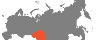
| A country | Russia |
| Subject of the federation | Kaliningrad region |
| Municipal district | Krasnoznamensky |
| Postcode | 238730 |
| City with | 1946 |
| Square | 8 km² |
| Timezone | UTC+3 |
| Population | ▲ 3393 people (2010) |
| Center height | 30 m |
| Based | 1576 |
| Vehicle code | 39, 91 |
| Coordinates | Coordinates: 54°57′00″ N. w. 22°30′00″ E. long / 54.95° north w. 22.5° east d. (G) (O) (I)54°57′00″ n. w. 22°30′00″ E. long / 54.95° north w. 22.5° east d. (G) (O) (I) |
| OKATO code | 27 218 501 |
| Former names | until 1734 - Lazdinai until 1938 - Lazdenen until 1946 - Haselberg |
| Telephone code | +7 40164 |
Krasnoznamensk (before 1938 - Lazdenen, German Lasdehnen, lit. Lazdynai, Polish odzienie; until 1946 - Haselberg, German Haselberg) is a city in Russia, the administrative center of the Krasnoznamensky district of the Kaliningrad region.
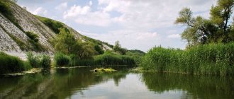
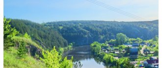
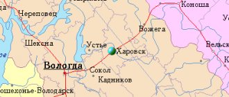
The city is located on the Sheshupa River (a tributary of the Neman), 164 km from Kaliningrad. 20 km from the city in the village of Pogranichny there is a checkpoint to Lithuania.
Population 3.4 thousand inhabitants (2009).
Architecture and landmarks
Church on Sheshup
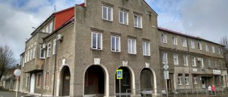
The city is built up mainly with one- or two-story German houses. The modern residential area is located on the high left bank. The industrial zone is located in the southern part of the city.
- Church (XIX century)
In the Krasnoznamensky district there are 17 objects classified as historical and cultural monuments, 4 archaeological monuments, 4 mass graves of soldiers who died in the Great Patriotic War, a memorial complex dedicated to F.S. Antipenkov.
Krasnoznamensk
As a result of numerous and lengthy wars between Lithuania, Poland and Prussia (XV - first quarter of the 16th centuries), the Principality of Lithuania became dependent on Poland. Many representatives of the Lithuanian nobility, as well as ordinary peasants, were not satisfied with the power of the Poles; they began to leave their lands and went to East Prussia, founding new settlements on undeveloped lands. The German authorities did not prevent such settlement along the banks of the Sheshupe River. Together with the Lithuanians, who made up the bulk of the settlers, representatives of the central regions of Prussia also settled here. The first settlement on the site of modern Krasnoznamensk is mentioned in written sources dating back to 1521. The German village of Haselpusch was located here. Since 1576, the village was also mentioned in the Lithuanian version - Lazdinai, which translated from Lithuanian means “hazel bushes”.
In 1578, a church was built in the village of Lazdinai, which burned down in 1661. The current church building was built in 1874–1877 in the neo-Gothic style. In 1663, the first water mill began operating in the village, which until 1893 belonged to the Brachvogels and was one of the most highly productive in the entire area. Over the years, Lazdinai developed into an important center of the East Prussian flour milling industry. Fairs were held in the city, attracting traders from all over the area.
In 1734, the settlement was renamed in German fashion, receiving the name Lasdehnen. In 1756–1763 Prussia participated in the Seven Years' War and was defeated by the Russian army in the Battles of Gross-Jägersdorf (1757) and Kunersdorf (1759). As a result, most of the Prussian provinces were occupied by Russians or Austrians. Lazdenen during this period was part of the Russian state. The first mention of Lazdenen in Russian military documents dates back to this time. In 1762, Emperor Peter III concluded a truce with the Prussian king Frederick II, returning the lands conquered by Russian troops.
In 1874, construction of the Lutheran Church (now the Cathedral of Saints Peter and Paul) began in Lazdenen according to the design of the Prussian architect Friedrich August Stüler, which was completed in 1877.
During the First World War, fighting took place in the Lazdenen area (January - February 1915), which became the last battles of the war on the territory of East Prussia. The 10th Army of General Thaddeus Vasilyevich Sivers was assigned the main role in carrying out the offensive operation against East Prussia. Sievers' army reached the line Goldap - Gumbinnen - Lazdenen. The plans of the German command were to defeat the right flank of the Russian front with the joint forces of the 8th and 10th armies. The Russian command decided to conduct the so-called Lazdenen operation in order to support the right flank, on which the Verzhbolovsky group of the 10th Army operated under the command of General Nikolai Alekseevich Epanchin, which took a position near the city of Lazdenen, in the rear of the main group. The German command managed to detect preparatory actions for an offensive operation in the direction of Lazdenen - Insterburg (now Chernyakhovsk) and organize a powerful counter-offensive. At the end of February 1915, General Epanchin began to withdraw the group from Lazdenen to Shirvindt (since 1947 - the village of Kutuzovo). Many died in the battles of 1914–1915. buried in the old cemetery of Krasnoznamensk - these are 157 Russian and 128 German soldiers.
In the post-war years, a period of active development of Lazdenen began, the village was transformed, acquiring the features of a city. In 1924, a bridge with a load capacity of 28 tons and a length of 77 meters was built across Sheshupe. A narrow gauge railway connected Lazdenen and Pilkallen (since 1947 Dobrovolsk) via Shillenen (now the village of Pobedino). There were industrial enterprises in the city: a gas plant, a brick and tile plant, a creamery, and a bakery. In Lazdenen there was a school, a pharmacy, a market, a hotel with a restaurant.
In 1932, Eva Danielchik opened a ceramic workshop in the city. She was the daughter of the owner of a brick factory, Wilhelm Danielczyk, and received a special education, graduating from a ceramics school in Bunzlau (now the city of Boleslawiec in Poland). Clay for the production of ceramics was mined from the quarries of Wilhelm Danielczyk. The workshop produced ceramic products under the “Classic Lazdenen” brand, which gained fame far beyond the borders of the Lazdenen area.
In the mid-1930s. About 2 thousand people lived in Lazdenen. In the second half of the 30s. The Lithuanian language was banned in East Prussia, and the city, on Hitler’s orders, was renamed in German - Haselberg (“Hazel Mountain”), a name it bore for 7 years.
City within the USSR, renamed Krasnoznamensk
In January 1945, fierce fighting took place in the Haselberg area. German troops tried to hold the defense line at any cost and prevent Soviet troops from entering Pillkallen (Dobrovolsk village).
On January 18, 1945, during the Insterburg-Koenigsberg offensive operation that began on January 13, the city was captured by troops of the 39th Army of the 3rd Belorussian Front. The troops who took part in the capture of Haselberg and other German cities were thanked by order of the Supreme Commander-in-Chief of January 19, 1945, and a salute of 224 guns with twenty artillery salvoes was given in Moscow.
On April 7, 1946 the city was renamed Krasnoznamensk. Haselberg suffered little damage during the fighting, and after the war the regional center was moved to Krasnoznamensk. In Krasnoznamensk, mostly one- and two-story German buildings have been preserved.
Demographics[edit]
Demographic trends[edit]
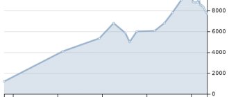
- 1,294 (1885 census)[9]
- 1857 (1910 census) [10]
- 2,065 (1933 census)[9]
- 2,070 (1939 census)[9]
- 2843 (1959 census)
- 2911 (1970 census)
- 3,392 (1979 census) [11]
- 3,894 (1989 census) [12]
- 3,751 (2002 census) [13]
- 3,522 (2010 census) [3]
Ethnic composition[edit]
According to the 2010 census: Russians - 87.4%, Lithuanians - 2.8%, Ukrainians - 2.5%, Belarusians - 2.5%, Roma - 1%, Armenians - 1%, Germans - 0.9%, Tatars - 0.6%, Poles - 0.5%. , others - 0.8%
Krasnoznamensk is in the ethnographic region known as Lithuania Minor, and Lithuanian cultural organizations exist in the city. [14]
Where religion is recorded in the census process, census data prior to 1945 show the religious affiliation of the population as Prussian-Evangelical.
Projectile in the bell tower
If you look at the top of the structure, you can see a Russian shell sticking out in the corner of the southeast part of the tower. He ended up there during the First World War.
After the ammunition hit the church and did not explode, local residents picked it up from the ground, deactivated it and installed it in the bell tower.
Since then, the shell has stuck out in the bell tower of the church, as a reminder of the troubles that the town and the church had to endure during the bloody wars.
Previously, kaskad.tv wrote about what to see during a trip to Neman.
Notes
- ↑ 12
www.gks.ru/free_doc/doc_2016/bul_dr/mun_obr2016.rar Population of the Russian Federation by municipalities as of January 1, 2016 - ↑ 12
[www.mojgorod.ru/kalining_obl/krasnoznams/ Krasnoznamensk in the people's encyclopedia “My City”] - [demoscope.ru/weekly/ssp/rus59_reg2.php All-Union Population Census of 1959. The size of the urban population of the RSFSR, its territorial units, urban settlements and urban areas by gender] (Russian). Demoscope Weekly. Retrieved September 25, 2013. [www.webcitation.org/6GDOghWC9 Archived from the original on April 28, 2013].
- [demoscope.ru/weekly/ssp/rus70_reg2.php All-Union Population Census of 1970 The size of the urban population of the RSFSR, its territorial units, urban settlements and urban areas by gender.] (Russian). Demoscope Weekly. Retrieved September 25, 2013. [www.webcitation.org/6GDOiMstp Archived from the original on April 28, 2013].
- [demoscope.ru/weekly/ssp/rus79_reg2.php All-Union Population Census of 1979 The size of the urban population of the RSFSR, its territorial units, urban settlements and urban areas by gender.] (Russian). Demoscope Weekly. Retrieved September 25, 2013. [www.webcitation.org/6GDOjhZ5L Archived from the original on April 28, 2013].
- [demoscope.ru/weekly/ssp/rus89_reg2.php All-Union Population Census of 1989. Urban population]. [www.webcitation.org/617x0o0Pa Archived from the original on August 22, 2011].
- ↑ 123456789
www.MojGorod.ru/kalining_obl/krasnoznams/index.html People's encyclopedia “My City”. Krasnoznamensk (Kaliningrad region) - [kaliningrad.gks.ru/wps/wcm/connect/rosstat_ts/kaliningrad/resources/67d5be0041e7f6558d13cd2d59c15b71/Number+and+location+of population.xls All-Russian Population Census 2002. Kaliningrad region. Number and distribution of population]. Retrieved February 3, 2014. [www.webcitation.org/6N6rTsRQJ Archived from the original on February 3, 2014].
- [www.gks.ru/bgd/regl/B09_109/IssWWW.exe/Stg/d01/tabl-21-09.xls Number of permanent population of the Russian Federation by cities, urban-type settlements and districts as of January 1, 2009]. Retrieved January 2, 2014. [www.webcitation.org/6MJmu0z1u Archived from the original on January 2, 2014].
- [kaliningrad.gks.ru/wps/wcm/connect/rosstat_ts/kaliningrad/resources/e9a049804e9f624b9e6e9f8e65563e6a/Results+All-Russian Population Census 2010_vol.1.xlsx All-Union Population Census 2010. Kaliningrad region. Table 10. Population of urban districts, municipal districts, urban and rural settlements, urban settlements, rural settlements]. Retrieved November 28, 2013. [www.webcitation.org/6LTFYTQqP Archived from the original on 2013-11-228].
- [www.gks.ru/free_doc/doc_2012/bul_dr/mun_obr2012.rar Population of the Russian Federation by municipalities. Table 35. Estimated resident population as of January 1, 2012]. Retrieved May 31, 2014. [www.webcitation.org/6PyOWbdMc Archived from the original on May 31, 2014].
- [www.gks.ru/free_doc/doc_2013/bul_dr/mun_obr2013.rar Population of the Russian Federation by municipalities as of January 1, 2013. - M.: Federal State Statistics Service Rosstat, 2013. - 528 p. (Table 33. Population of urban districts, municipal districts, urban and rural settlements, urban settlements, rural settlements)]. Retrieved November 16, 2013. [www.webcitation.org/6LAdCWSxH Archived from the original on November 16, 2013].
- [www.gks.ru/free_doc/doc_2014/bul_dr/mun_obr2014.rar Table 33. Population of the Russian Federation by municipalities as of January 1, 2014]. Retrieved August 2, 2014. [www.webcitation.org/6RWqP50QK Archived from the original on August 2, 2014].
- [www.gks.ru/free_doc/doc_2015/bul_dr/mun_obr2015.rar Population of the Russian Federation by municipalities as of January 1, 2015]. Retrieved August 6, 2015. [www.webcitation.org/6aaNzOlFO Archived from the original on August 6, 2015].
- taking into account the cities of Crimea
- [www.gks.ru/free_doc/doc_2016/bul_dr/mun_obr2016.rar Population of the Russian Federation by municipalities as of January 1, 2016. Table “31. Population of cities and towns by federal districts and constituent entities of the Russian Federation as of January 1, 2016.” RAR archive (1.0 MB)]
- [kaliningrad.gks.ru/wps/wcm/connect/rosstat_ts/kaliningrad/ru/census_and_researching/census/national_census_2010/score_2010/ Results:: Kaliningradstat]
- ↑ 12
[www.b-kld.ru/catalog/?company=58988 Business Kaliningrad] - ↑ 12
[www.mycicerone.ru/wiki/Krasnoznamensk Krasnoznamensk on MyCicerone.ru]