| Coat of arms of Kaltan (Kemerovo region) | |
| A country | Russia |
| Subject of the federation | Kemerovo region |
| Urban district | Kaltan urban district |
| Postcode | 652740, 652741 |
| Based | 1946 |
| Timezone | UTC+7 |
| City with | 1959 |
| OKATO code | 32 415 |
| Coordinates | Coordinates: 53°31′00″ N. w. 87°16′00″ E. d. / 53.516667° n. w. 87.266667° E. d. (G) (O) (I)53°31′00″ n. w. 87°16′00″ E. d. / 53.516667° n. w. 87.266667° E. d. (G) (O) (I) |
| Center height | 225 m |
| Density | 791 people/km² |
| Internal division | 6 territories: Kaltan, village. Permanent, village Shushtalep, village Malyshev Log, village Malinovka, c. Sarbala |
| Vehicle code | 42 |
| Official site | https://kaltan.net/ |
| Square | 32.36 km² |
| Telephone code | +7 38472 |
| Chapter | Goldinov Igor Fedorovich |
| Population | ▼ 24,841[1] people (2010) |
| Climate type | sharply continental |
| Agglomeration | Novokuznetsk agglomeration |
| Ethnobury | Kaltanets, Kaltanians |
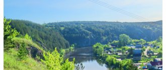
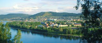
Kaltan is a city of regional subordination in the Kemerovo region, the administrative center of the Kaltan urban district. It acquired the status of regional subordination in 1993 and is considered one of the cleanest and greenest cities in the region.
Population
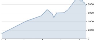
| Number of inhabitants of the city of Kaltan by year (in thousands) | |||||||||||||||||||||||
| Year | 1959 | 1967 | 1970 | 1979 | 1989 | 1992 | 1996 | 1998 | 2000 | 2001 | 2003 | 2005 | 2006 | 2007 | 2008 | 2009 | |||||||
| Qty | 26,6 | 28,0 | 28,0 | 25,0 | 25,4 | 25,8 | 26,5 | 26,4 | 26,1 | 25,9 | 26,0 | 25,3 | 25,0 | 24,9 | 24,8 | 24,9 | |||||||
Age structure of the population: below working age - 16.5%, in working age - 60.5%, above working age - 23%. The share of the city's population in the population of the Kemerovo region is 0.9%.
Notes
- ↑ 12
www.gks.ru/free_doc/doc_2016/bul_dr/mun_obr2016.rar Population of the Russian Federation by municipalities as of January 1, 2016 - [docs.cntd.ru/document/990309084 Law of the Kemerovo Region of December 17, 2004 No. 104-OZ On the status and boundaries of municipalities]
- [demoscope.ru/weekly/ssp/rus59_reg2.php All-Union Population Census of 1959. The size of the urban population of the RSFSR, its territorial units, urban settlements and urban areas by gender] (Russian). Demoscope Weekly. Retrieved September 25, 2013. [www.webcitation.org/6GDOghWC9 Archived from the original on April 28, 2013].
- ↑ 12345678910
www.MojGorod.ru/kemerovsk_obl/kaltan/index.html People's encyclopedia “My City”. Kaltan - [demoscope.ru/weekly/ssp/rus70_reg2.php All-Union Population Census of 1970 The size of the urban population of the RSFSR, its territorial units, urban settlements and urban areas by gender.] (Russian). Demoscope Weekly. Retrieved September 25, 2013. [www.webcitation.org/6GDOiMstp Archived from the original on April 28, 2013].
- [demoscope.ru/weekly/ssp/rus79_reg2.php All-Union Population Census of 1979 The size of the urban population of the RSFSR, its territorial units, urban settlements and urban areas by gender.] (Russian). Demoscope Weekly. Retrieved September 25, 2013. [www.webcitation.org/6GDOjhZ5L Archived from the original on April 28, 2013].
- [demoscope.ru/weekly/ssp/rus89_reg2.php All-Union Population Census of 1989. Urban population]. [www.webcitation.org/617x0o0Pa Archived from the original on August 22, 2011].
- [www.perepis2002.ru/ct/doc/1_TOM_01_04.xls All-Russian Population Census 2002. Volume. 1, table 4. Population of Russia, federal districts, constituent entities of the Russian Federation, districts, urban settlements, rural settlements - regional centers and rural settlements with a population of 3 thousand or more]. [www.webcitation.org/65AdCU0q3 Archived from the original on February 3, 2012].
- [www.gks.ru/bgd/regl/b08_14t/IssWWW.exe/Stg/s/09-00.htm Cities of the Kemerovo region (number of inhabitants - estimate as of January 1, 2008, thousand people)]. Retrieved June 1, 2016. [www.webcitation.org/6hwJBGYKL Archived from the original on June 1, 2016].
- [www.gks.ru/bgd/regl/B09_109/IssWWW.exe/Stg/d01/tabl-21-09.xls Number of permanent population of the Russian Federation by cities, urban-type settlements and districts as of January 1, 2009]. Retrieved January 2, 2014. [www.webcitation.org/6MJmu0z1u Archived from the original on January 2, 2014].
- [kemerovostat.gks.ru/wps/wcm/connect/rosstat_ts/kemerovostat/resources/ff43230040e572408ffeef367ccd0f13/1.6.pdf All-Russian Population Census 2010. Kemerovo region. 1.6. Population of urban districts, municipal districts, urban and rural settlements, urban settlements, rural settlements]. Retrieved July 26, 2014. [www.webcitation.org/6RMInOgkU Archived from the original on July 26, 2014].
- www.gks.ru/dbscripts/munst/munst32/DBInet.cgi?pl=8112027 Kemerovo region. Estimated resident population as of January 1, 2009-2016
- [www.gks.ru/free_doc/doc_2012/bul_dr/mun_obr2012.rar Population of the Russian Federation by municipalities. Table 35. Estimated resident population as of January 1, 2012]. Retrieved May 31, 2014. [www.webcitation.org/6PyOWbdMc Archived from the original on May 31, 2014].
- [www.gks.ru/free_doc/doc_2013/bul_dr/mun_obr2013.rar Population of the Russian Federation by municipalities as of January 1, 2013. - M.: Federal State Statistics Service Rosstat, 2013. - 528 p. (Table 33. Population of urban districts, municipal districts, urban and rural settlements, urban settlements, rural settlements)]. Retrieved November 16, 2013. [www.webcitation.org/6LAdCWSxH Archived from the original on November 16, 2013].
- [www.gks.ru/free_doc/doc_2014/bul_dr/mun_obr2014.rar Table 33. Population of the Russian Federation by municipalities as of January 1, 2014]. Retrieved August 2, 2014. [www.webcitation.org/6RWqP50QK Archived from the original on August 2, 2014].
- [www.gks.ru/free_doc/doc_2015/bul_dr/mun_obr2015.rar Population of the Russian Federation by municipalities as of January 1, 2015]. Retrieved August 6, 2015. [www.webcitation.org/6aaNzOlFO Archived from the original on August 6, 2015].
- [government.ru/media/files/41d4f68fb74d798eae71.pdf Order of the Government of the Russian Federation dated July 29, 2014 N 1398-r “On approval of the list of single-industry towns”]
Economy
Trade enterprises
- Supermarket "Blizhny"
- Shopping center "Maria-Ra"
- "El Dorado"
- "Pelican"
- "Euroset"
- Supermarkets "Chibis"
- Supermarket "Solnyshko"
- "Svyaznoy"
- "Watercolor"
A number of other food and non-food stores
Industrial enterprises
- Branch "Alardinskaya Mine" of OJSC "OUK "Yuzhkuzbassugol"
- South Kuzbass Production Plant (YKPK)
- Branch "Kaltansky coal mine" of OJSC Management Company "Kuzbassrazrezugol"
- Kaltan metal structures plant
- Southern Kuzbass Power Plant
- KVOiT Plant (Boiler-auxiliary equipment and pipelines)
- Kaltan brick factory
Kaltan
origin of name
Kaltan local historians do not give an exact answer to the question of how the name of the city appeared. There are a huge number of versions of the explanation of the toponym. In V.I. Dahl’s dictionary you can find the following interpretation of the word “kaltan”: young Siberian summer sable. According to another version, kaltan in the Shor dialect means “black stone” (most likely, black stone means coal). The third version translates the name of the city as “unreasonable winter frosty wind.” This interpretation may also be quite plausible, given local climatic conditions. Another interpretation of the toponym: kaltan is a piece of land devoid of forest, located on a hill.
Background
The territory of the modern city was populated in waves. In addition to the Shors, other tribes and nationalities lived here, who came to this land at different times. Presumably, each new people who settled on the territory of present-day Kaltan changed the toponym in their own way, since the existing name was too difficult for them.
The history of the city originates from the village of Upper Kaltan, where the Kaltan redoubt was located. It was erected on the right bank of the Kondoma after the construction of the Kuznetsk fort was completed. From the 17th to the 19th centuries, the area where the city is located today was part of the Kuznetsk fortified line. Until the twentieth century, the Shor ulus was located on the territory of present-day Kaltan.
In ancient times, the Shor tribes lived in the valleys of the Kondoma and Tom rivers. The Shors constantly suffered from oppression from tribes that came from Khakassia. In 1607, Russian settlers came to the territory of today's Kemerovo region. The Shor tribes greeted the Russians very kindly, seeing in the unfamiliar people a force that would protect them from oppression. However, the Shors refused to accept foreign culture. The tribes were engaged in collecting forest gifts, hunting and fishing. Agriculture was practically not practiced.
Some time after the Russians settled on the Shor lands, the Shors decided to move a little east of the foreigners. In the new place, the tribes founded several settlements, the names of which included the word “kaltan”: Nizhny Kaltan, Red Kaltan, etc. Since in the new place the Shors also continued to fight the raids of the Khakassians, they decided to join the Russian state. According to the royal decree signed in 1618, the Kuznetsk fort was erected. The fortification was located on the mountainous right bank of the Tom River, not far from the Aba River and the mouth of the Kondoma. Kuznetsk at that time was already one of the southern outposts of the Russian state. By the 1640s, the Kuznetsk fortification line was created, which had a length of 300 km. There were more than three dozen fortresses and redoubts on this line.
Upper Kaltan
Upper Kaltan turned out to be one of the most convenient places for the Cossacks to settle. This territory was already inhabited by the Shors. By 1884, more than four dozen houses had been built in Kaltan. The village was governed by the sotsky and the headman, who were elected at a general meeting. The headman collected taxes, appointed village residents to public works, distributed land and hayfields, supervised the collection of pine nuts, etc. A church was built in the village, thanks to which Kaltan became a village. Cossack children had the opportunity to learn to read and write thanks to political exiles.
Ore deposits were discovered in the village of Telbes. And not far from Sarbala, coal was found in Tailep Mountain. Since the ironworks in Guryevsk needed coal, local residents floated coal there by river (in summer) or transported it by sleigh (in winter). The Biysky (Kuznetsky) tract passed through Kaltan, which also passed through Ashmarino, Tailep and Sary-Chumysh. Thanks to the discovery of coal and the emergence of the Kuznetsk tract, the number of traders and artisans increased sharply. By 1913, more than a hundred houses had already been built in the village of Kaltan. The settlement was divided into Upper and Lower Kaltan.
After the revolution of 1917, a partnership for joint cultivation of the land was organized in Kaltan. Then the communes “Sadovaya” and “Bednyak” appeared here, as well as the industrial artel “Gra”, the collective farms “Pamyat Ilyich” and “Red Dawn”. Despite the presence of natural resources, industry on Kaltan land began its development only in the post-war years. Industrial development required huge amounts of electricity. It was economically unprofitable to supply energy to a region remote from the center.
Industrial development of Kaltan
In 1946, Kaltan received the status of a workers' village. In the same year, a decision was made to build a power plant, and a site was selected for the construction site. The thermal power plant was to be built as the largest in Siberia. The first industrial current was obtained at the end of April 1951. The electric generator and turbine had a power of 100 thousand kW. In Siberia it was the first turbine with such power. In 1956, the construction of the YuK GRES was completely completed, which made it possible to build and expand local industrial facilities: the ferroalloy and aluminum plants of Novokuznetsk. The opportunity arose to build new chemical plants and mines. In addition, residential buildings and agriculture needed electricity.
After a power plant appeared in the village, the Kaltan administration began improving the workers' village. In Kaltan, the construction of new comfortable houses, kindergartens, shops, social and cultural institutions, hospitals, canteens, schools, etc. began. Thanks to the Yuzhno-Kuzbass State District Power Plant, new enterprises appeared: the plant of boiler-auxiliary equipment and pipelines (KVOiT), Yuzhno-Kuzbass Kuzbass Production Plant (YUK PK), brick factory and others. SK PK was supposed to provide construction materials not only to SK GRES, but also power plants under construction in the Urals, Siberia and the Far East. Lumber, floor slats, window and door units, bricks and precast concrete were delivered to the power plant. Nowadays, YUK PK is engaged in the production of hollow-core floor panels, reinforced concrete vibrating racks for supporting high-voltage power lines and other products in demand in the domestic and foreign markets. At the end of the 90s, the company began producing a new thermal insulation material - penoizol. The KVOiT enterprise produces: chemical water treatment pipelines, steeply curved bends, welded bends, flange connections, turned transitions, supports and hangers, battery cyclones, tees, etc.
Mines and cuts
In May 1949, Kaltan became an urban-type settlement. In the early 50s, the Shushtalepskaya mine began operating in the village, the planned production of which was 600 thousand tons of coal annually. The mine ensured the development of the villages of Permanent and Malyshev Log, and also supplied coal to the YuK State District Power Plant. Over time, the Northern Kandysh mine separated from the Shushtalepskaya mine and became completely independent. Fuel for local needs was extracted at Northern Kandysh. In 1998, a restructuring was carried out, as a result of which, on the site of the Shushtalepskaya mine, the Kondomskoye mine was created (currently closed). At the end of the 90s, the Zapadny open-pit mine appeared on the site of the Northern Kandysh mine.
The Kaltansky open-pit mine became an independent enterprise in 1982. Thermal coal of grade "T" ("skinny") was mined here. At the end of the 70s, coal production at this mine was more than seven hundred thousand tons. In the 1990s, there was a downward trend in the amount of coal mined. Currently, thanks to the presence of new, more advanced equipment, more than a million tons of coal are mined at the open-pit mine annually. In 2003, a railway line was built for transportation.
Kaltan city
In 1959, the working village of Kaltan was transformed into a city. In 1993, Kaltan became a city of regional subordination. And in January 2006, the settlement received the status of an urban district.
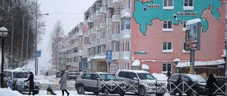
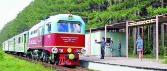
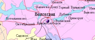
Today's Kaltan has a modern urban infrastructure, developed industry and an equally developed structure of social institutions. Industrial enterprises of various industries - coal mining, electric power, etc. - ensure the life of the city. A section of the main railway connecting Tashtagol and Novokuznetsk and providing a connection with the railway network of the Russian Federation passes through Kaltan.
Also, the Osinniki-Kaltan regional highway passes through the city. It connects the city with the Altai Territory, the eastern and northern Siberian regions and Tashtagol. After the construction of the highway between Gorno-Altaisk and Tashtagol was completed, the route, which had the status of regional significance, becomes transit and acquires the status of federal significance. It connects Western Siberia with Mongolia, the Altai Mountains and China. In 2005, the bridge over the Condoma River was reconstructed, which should significantly improve transit communications.
Physiographic characteristics
Timezone
The city of Kaltan, like the entire Kemerovo region, is located in a time zone designated by international standard as Omsk Time Zone (OMST). The offset relative to UTC is +7:00. Relative to Moscow time, the time zone has a constant offset of +3 hours and is designated in Russia accordingly as MSK+3. Omsk time differs from standard time by two hours.
The central part of Kaltan in the 1960s
Geographical position
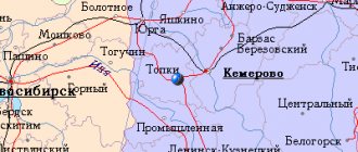
How to get to the city
Climate
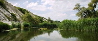
The average annual air temperature is +0.80 °C. On average there are 280 sunny days a year. The average duration of the frost-free period is 123 days. The city is located in a zone of sufficient moisture: on average, about 600 mm of precipitation falls, with about 450 mm falling during the warm period. The duration of snow cover is about 160 days. The average depth of soil freezing in the city is about 190 cm. The predominant wind direction is south and south-west. The average annual wind speed is 2.3 m/sec. At the same time, the frequency of calm weather is 25%.
Add a comment
Comment
Send