By the beginning of the 21st century. Almost half of the population of world civilization lived in cities. Cities play a leading role in the economic, socio-political and socio-cultural life of countries and peoples of the world. Cities produce 4/5 of the value of all goods and services produced in the world. Thus, modern world civilization is, first of all, an urban civilization. The main direction in the development of society is its urbanization. The peculiarities of the concentration of population and economic life in cities, the spread of their influence on the agrarian environment constitute the core of the historical process in Modern and Contemporary times. Understanding the essence of modernization of society is impossible without identifying the main stages of urbanization.
The cities of the Urals occupy a special place in the history of Russia. And today they play an important role in the economic, socio-political and socio-cultural development of the country.
Of the 1040 cities in Russia, 140 are located in the Urals, of the 13 million-plus cities, 4 are Ural cities (Ekaterinburg, Perm, Ufa, Chelyabinsk).
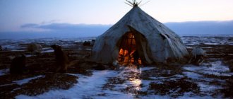
How did the formation of the Ural cities proceed in historical dynamics? Their formation and development can be divided into three large stages. The first covers the pre-industrial era (XV-XVII centuries), when 33 cities arose in the Urals1. At the time of their formation, these were mainly settlements, small villages and fortresses, which became an outpost for the development of the vast expanses of the Urals and Siberia, and did not play the role of industrial and administrative centers.
The second stage of urbanization of the Urals began with the beginning of Peter the Great’s modernization in the first quarter of the 18th century, when such fortress factories as Kamensk-Uralsky, Nevyansk, Yekaterinburg, etc. were founded. This stage continued until the start of capitalist modernization of Russia in the second half of the 19th century. It turns out that such cities make up the majority in the Urals. There are 73 of them, and 65 of them arose in the 18th century. These were mainly factory cities, where the industrial power of the “backbone of the state” was built.
The third stage of development of the cities of the Urals, urbanization of the region covers the period from the last third of the 19th century. until the end of the 1920s. This is the era of capitalist modernization of Russia, wars, revolutions, restoration of the national economy, the eve of the “Stalinist industrial revolution.” At this stage, 16 new cities arose on the map of the Urals, the birth of which is associated, as a rule, with the development of new mineral deposits (for example, Asbest, 1889), the construction of a railway (Bogdanovich, 1883) or the construction of new large factories ( Serov, 1899).
Of course, the process of urbanization in the region accelerated sharply during socialist industrialization. However, few new cities emerged in the “Stalin era,” as in the subsequent decades of Soviet power. From the late 1920s to 1989 15 cities2 appeared on the map of the Urals, starting with Magnitogorsk in 1929 and ending with the city of Dyurtyuli (Bashkortostan) in 1989. All of them, with rare exceptions, arose as a result of the development of newly discovered mineral deposits (for example, Kachkanar, 1956) or the construction of new large industrial enterprises (Magnitogorsk, 1929). The process of urbanization of the Urals in the twentieth centuries. was mainly due to the growth of the population of cities that arose in the pre-industrial era (XV-XVII centuries) and during the period of pre-capitalist modernization of Russia (XVIII - first half of the 19th centuries).
Where is the Urals located on the map of Russia
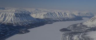
The Urals are located simultaneously in the Asian and European sides of the world. The mountains stretch from the very North to the southern Kazakhstani regions, and their length is 2500 km. The mountains themselves are a system of massifs and ridges of different heights, the peak reaches 1700 m, and the lowest point 600 m.
The Urals are divided into:
- Southern Urals (Bashkortostan, Kurgan, Chelyabinsk and Orenburg) . Here the steppe gives way to forest.
- Middle Urals (Sverdlovsk and Perm) . There is taiga and forest everywhere.
- Northern, Subpolar and Polar Urals (Nenets Autonomous Okrug and Komi Republic) . In these areas, the taiga gives way to tundra.
The area of the Urals is 781.1 thousand km2, which is 4.5% of the area of Russia.
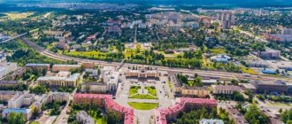
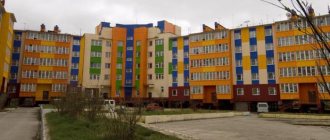
Nizhny Tagil is a cultural and industrial center of the Urals
The central place in the economy of Nizhny Tagil is occupied by industry related to metallurgy. The city is famous for the construction of carriages, design bureaus, and production of metal structures, thermal insulation products, and industrial ventilation. On its territory there are various factories engaged in the following activities:
- production of knitted products;
- oil refining;
- furniture production;
- ice cream production;
- release of flanges.
Despite the fact that a number of enterprises have gone bankrupt in recent years, the city remains a major industrial center directly related to the defense industry.
The authorities of Nizhny Tagil are striving to develop tourism, with the main emphasis being on nature. The region where the city is located is picturesque and worth a visit. The list of parks is significant, the main one of which is the Bondin Central Park of Culture and Recreation. There are many museums at the disposal of travelers, most of which are dedicated to nature. The most interesting souvenirs that you can bring are trays. This is due to the development of lacquer painting, which has historical roots. Lovers of religious architecture will appreciate the large number of Orthodox churches and parishes. Now Nizhny Tagil constantly hosts exhibitions, most of them focused on defense and military equipment. Medicine, which is aimed at maintaining the working capacity of the population, is of great importance, because many city residents are factory workers. The large cities of the Urals are an example of industrialization on a national scale. They are not as large in area as many megacities, but they provide the region with significant income.
Kurgan is a developed industrial city
The industry of a large city remains in first place. It is more attractive to specialists from various industries than to tourists. Although the city is notable in terms of tourism. Mechanical engineering and metalworking are the main types of industry; in recent years, great emphasis has been placed on the development of the production of medical equipment.
Kurgan is also becoming one of the important pharmaceutical centers; the Velpharm enterprise plans to produce over 60 different drugs. There are 6 research institutes located on the territory of Kurgan. Design bureaus occupy a central place in the engineering sector. It was thanks to the Kurgan physician Ilizarov that a unique and universal treatment method was obtained, which makes it possible to treat pathologies of large joints without serious surgical intervention, use a non-transplantation method of treatment to replace bone defects, and treat complex fractures regardless of location. This technique is used in many countries around the world. Kurgan can be called a city of monuments - their list is really long. Museums, cultural parks, theaters and libraries will help diversify cultural leisure. Orthodox churches are of significant value; there is also a Muslim cathedral mosque in Kurgan.
List, description and photos of top attractions in Perm
Perm
When choosing what to see and which attractions of the Urals to visit, you should pay attention to the city of Perm. Its foundation was facilitated by the construction of the Yegoshikha copper processing plant. The official date of the city's creation is considered to be May 4, 1723. The modern city of Perm is unique in its diversity of architectural styles - throughout the history of the city, wooden buildings were replaced by brick buildings, each of which corresponds to the style and design of a certain period of time.
Meshkov's House
Meshkov's House
This landmark is one of the mansions in the historical center of Perm. Construction of the house was completed in 1889. Initially, the mansion was built in accordance with the style of late Russian classicism, but later it was rebuilt into a picturesque modern style. Today the mansion houses the Perm Museum of Local Lore, and the building itself is a cultural heritage site.
Gribushin House
Taking its name from the owner, Gribushin’s mansion was built in 1897 in the Baroque style with the addition of Art Nouveau elements. Decorated in blue and white colors, the building is decorated with Corinthian order and columns. The landmark is considered one of the most unique historical buildings in Perm. The inner and outer layers are made of brick, the middle one is made of larch. The facade and rooms of the mansion are decorated with stucco decorations, including the faces of women from Gribushin’s family photos.
Other sights of Perm: description and photos
Perm State Academic Opera and Ballet Theater named after. Tchaikovsky
Perm is rich in historical and cultural attractions that are worth photographing for your collection. Each of these monuments has its own unique history and architectural features, which have made them famous throughout Russia and beyond.
The sculptures deserve special attention, including the monument to Lenin, unveiled in 1954, and the monument to Pavel Preobrazhensky, the professor who discovered the first oil field in the Urals. There are other monuments and attractions in Perm that tourists should definitely see and take photos as a souvenir. Descriptions of their creation and history can be heard by booking a guided tour of the city.
Socio-economic definition of the Ural territory
Different from the geographical and political definitions of the Urals. The formation of economic regions is an objective process expressed by the development of the territorial division of labor.
There are only 11 economic regions defined within the Russian Federation. The area of the Ural economic region is 824 thousand sq. km.
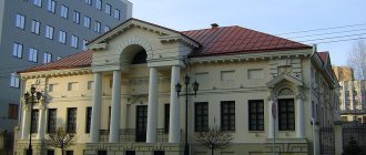
Cherdyn - an ancient Perm city
Cherdyn bears the title of the first Russian city in the Urals. The exact date of settlement of this area by people is unclear, but archaeologists have found traces of an ancient settlement dating back to the 12th-13th centuries. The first mention of the city dates back to 1451, when a governor was sent to these lands. In 1535, the first Kremlin in the Urals, called Cherdynsky, was built here. The fortification was made of wood and has not survived to this day, but restoration work made it possible to recreate several towers and part of the wall.
In the 16th and 17th centuries, the city was considered a large and developed center, with more than 300 courtyards and dozens of trading establishments. In addition, it had the status of one of the most important religious centers: in 1624 there were 16 wooden and several stone temples. The most notable of those that have survived to this day is the Church of St. John the Evangelist from 1718. The Cathedral of the Resurrection of Christ in 1817 also deserves attention.
The most popular attractions of the Urals
The most unique region of Russia, the Urals, is mainly represented by a mountain system and is located between two plains - West Siberian and East European. Connecting two parts of the world - Europe and Asia - the Ural region combines the nature and climatic features of both sides. That is why, rich in minerals, it has become a popular tourist area. Numerous sights of the Urals, photos with descriptions of which can be seen on our website, were created over many centuries: both by nature and by man.
The development of the Urals began with the discovery of a huge amount of minerals here. Numerous deposits of copper, gold, iron, platinum and various mineral resources have made this region the metallurgical and mining center of Russia. The creation of factories and enterprises required improvement and development of the social sphere of life. This is how many cities of the Urals appeared, which today represent not only an industrial, but also a successfully developing tourist area.
Historical sites and museums
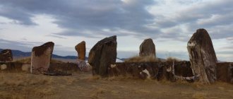
Arkaim (settlement, Mountain of Love, Mountain of Reason, Mountain of Revelation, Mountain Shaman and Mountain of Ancestors)
Coordinates: 52.642172, 59.543212 Phone: 8 904-800-40-56 Website: https://www.arkaim-center.ru Cost of excursions: 50-250 rubles
Arkaim is an ancient settlement of the Bronze Age. It was discovered by chance: two schoolchildren from an archaeological group noticed the unusual relief.
The ancient city looks like a circular fortress with residential and utility rooms, workshops, a central square, and a sewer system.
It is not known how many years people lived in the city, but after a strong fire no one else settled here.
Arkaim is surrounded by mountains, which were important in the lives of the townspeople. Religious ceremonies were held on Mount Shamanka. Mountain of Love was a symbol of a happy family life. The Mountain of Reason, according to legend, bestowed clarity of mind and knowledge. The Mount of Revelation was considered the main place of power. And the Mountain of Ancestors is also called the Mountain of Repentance - a place where people could admit their imperfections.
Leaning Nevyansk Tower
Address: Sverdlovsk region, Nevyansk, Demidov Square, 3 Phone: +7 34356 4‑45-09, +7 906 811‑48-21 Website: https://nevyanskmuseum.rf Opening hours: Tue-Fri 9:00 -19:00; Sat 9:00-20:00; Sun 9:00-19:00
The tower, built in memory of the commissioner of the Nevyansk plant N. Demidov, has a strong slope.
This is probably the result of a construction error. The tower was completed already tilted, maintaining the center of gravity. Thus, the structure has a saber shape.
For that time, the tower had a modern device: it was equipped with a lightning rod long before its invention by Benjamin Franklin.
Ganina Yama
Location: Ekaterinburg, Shuvakish Phone: +7 343 219‑08-48, +7 953 007‑18-45 Website: https://ganinayama.ru Opening hours: 6:00-21:00 Mon-Sun
This place was discovered in the mid-19th century as an iron mine. But it became known as the burial place of the bodies of members of the royal family killed in 1918.
Now there is a monastery complex consisting of several churches and additional buildings.
Didinsky tunnel
Location: village. Didino, Pervouralsk, Sverdlovsk region
Abandoned railway tunnel. It was built in 1918 and operated for 77 years.
Svyato-Kosminskaya hermitage
Address: Sverdlovsk region, Kostyleva village, st. Central, building, 16a Phone: +7 (34389) 21-501, 21-503
In pre-revolutionary times, there was a chapel on this site. The modern monastery was built in the early 2000s.
This is a monastery open to pilgrims. There is a hotel attached to the complex.
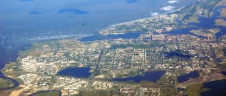
Ekaterinburg is a diverse metropolis
Ekaterinburg occupies an important position and is considered one of the largest centers in the world, the basis of which is the industrial sector. The city's gross product is constantly growing, and by 2025 it is expected to reach $40 billion, according to calculations by the research organization McKinsey Global Institute. The volume of Yekaterinburg's economy is so large that its pace is ahead of many large cities, equal to Moscow and St. Petersburg.
The industry of Yekaterinburg has developed since the 18th century. The main type is heavy engineering. The city still retains its specialization, with more than 200 enterprises located on its territory. Moreover, some of them work for the needs of the defense complex. The metropolis has acquired considerable importance as a tourist center. The flow of tourists is growing every year, which is due to the large number of attractions. There are several architectural monuments here, among which the most famous are:
- Sevastyanov's House;
- Rastorguev-Kharitonov estate;
- Tarasov's estate.
The historical center has amazing beauty. Yekaterinburg can safely be called the capital of the Urals, because the list of leisure ideas here is unusually large.
Magnitogorsk is a cultural and business center
The central position of the economy of Magnitogorsk is still occupied by the production of metallurgical products. A large number of enterprises engaged in the industrial sector provide significant (multi-billion dollar) turnover. This at the same time has a bad effect on the ecology of the city. Magnitogorsk is comparable to megacities where there is an unfavorable environmental situation due to the concentration of harmful substances such as iron oxide, nitrogen dioxide, formaldehyde, carbon monoxide and others.
Now it still ranks at the top of the list of environmentally unfavorable cities. Students flock here to study at a state university. The main specialties are technical. For cultural leisure, Magnitogorsk offers theaters, circuses, museums, libraries and cinemas. As in Chelyabinsk, in terms of sports, Magnitogorsk residents prefer hockey. Magnitogorsk has always served the needs of the front, as evidenced by its monuments. For example, the famous monument “Rear to Front” represents two warriors. Many monuments are dedicated to workers, military equipment, and various social phenomena. There is a monument to the first steam locomotive, parents, teacher, janitor, plumber and even a blast furnace operator.