Kachkanar is one of the highest mountains in the Middle Urals, and among the easily accessible ones it is the first in height. Few peaks in this part of the Urals can compare with it in beauty, and on the top of the mountain is the first and only Buddhist monastery in our region. In this article I will tell you about all the most important and interesting things related to Mount Kachkanar.
origin of name
Researcher of toponyms of the Urals A.K. Matveev gives three main versions of the origin of the name of the mountain.
- The name may be of Mansi origin. In Mansi “ner” means “stone mountain”, “Ural”, but deciphering the first part of the name turned out to be difficult. By the way, there is information that in ancient times there was a Mansi sanctuary on the top of the mountain.
- From the Turkic “kashka-nar” - “bald camel”. Given the rock at the top, which looks very similar to a camel, this version seems most likely. However, there is one big “but”: the Mansi lived in these places, not the Bashkirs and Tatars.
- There is a third option, also related to the Turkic version - from the Tatar “kachkynnar” - “fugitives”.
Features of Mount Kachkanar
Mount Kachkanar rises between the valleys of the Is and Vyya rivers, two tributaries of the Tura River. The height of Mount Kachkanar reaches 878.8 m . Among other peaks of the Middle Urals within the Sverdlovsk region, it has no equal (but do not confuse it with the higher Northern Urals and do not forget about Mount Oslyanka).
Mount Kachkanar stretches from northwest to southeast and has two peaks - northern and southern. They are called the Northern Horn (878 m) and the Midday Horn (874 m). There are about 2 km between them. Each of the peaks is beautiful in its own way. The slopes of the mountain are covered with forest, many cedars grow. At the top there are scattered stones and very beautiful rocks of various shapes and sizes.
Tourists visit mainly the northern peak. The rocks on it are especially impressive. Here lies a whole stone city with remains of bizarre shapes. Lots of rocks with holes through them. Some of the rock outcrops have their own names.
The most famous and popular is the Camel rock , which is surprisingly similar to this animal. Camel is a favorite place for photo shoots. All tourists climbing the mountain are sure to take pictures here as a souvenir.
The main peak of Mount Kachkanar is outwardly unremarkable. It is located on one of the small rocks, marked by a geodetic tour - a concrete pillar with a vertically protruding iron pipe. You can reach the highest point along the trail from the Camel.
If you continue along the path in a western direction, you can get to the Rocket Rock (aka Gagarin Peak). There is a metal monument in the shape of a rocket installed here in honor of Yuri Gagarin's significant flight. The monument is painted from time to time, but it still constantly suffers from vandals writing their names. From here you can clearly see the village of Kosya and its surroundings with numerous “wounds” from platinum mines.
Mount Kachkanar is beautiful at any time of the year and in any weather. Both in winter and summer, this peak enchants in its own way. In good weather, there are beautiful views of the surrounding area from above. But often the peak finds itself in low clouds, in fog of varying degrees of density. At this time, a special, mysterious atmosphere arises in the stone city of Kachkanara.
It is always much colder at the top, and a piercing wind often blows. There are no reliable sources of water at the top, but for cooking you can get water from the puddle holes under the rocks. There is also a small lake in a quarry not far from the northern peak.
On the slope of the mountain there is a track of a former ski resort . Previously, it belonged to the Kachkanarsky GOK, then the enterprise abandoned it, transferring it to the city, which led to the closure of the base. In the late 2000s – early 2010s, a project arose with the code name “Ural Meridian”, which involved the construction of a ski resort and the creation of a large tourist cluster on its basis. Officials saw this as a chance to diversify the economy of the single-industry town, which was completely dependent on one single enterprise. The emphasis was placed on a height difference of about 600 m, unique for the Middle Urals, which made it possible to lay a route of about 2.5 km. But as is usually the case, everything was limited to just beautiful presentations, but it never came to fruition.
Notes
- ↑ 123
www.gks.ru/free_doc/doc_2016/bul_dr/mun_obr2016.rar Population of the Russian Federation by municipalities as of January 1, 2016 - [demoscope.ru/weekly/ssp/rus59_reg2.php All-Union Population Census of 1959. The size of the urban population of the RSFSR, its territorial units, urban settlements and urban areas by gender] (Russian). Demoscope Weekly. Retrieved September 25, 2013. [www.webcitation.org/6GDOghWC9 Archived from the original on April 28, 2013].
- [demoscope.ru/weekly/ssp/rus70_reg2.php All-Union Population Census of 1970 The size of the urban population of the RSFSR, its territorial units, urban settlements and urban areas by gender.] (Russian). Demoscope Weekly. Retrieved September 25, 2013. [www.webcitation.org/6GDOiMstp Archived from the original on April 28, 2013].
- [demoscope.ru/weekly/ssp/rus79_reg2.php All-Union Population Census of 1979 The size of the urban population of the RSFSR, its territorial units, urban settlements and urban areas by gender.] (Russian). Demoscope Weekly. Retrieved September 25, 2013. [www.webcitation.org/6GDOjhZ5L Archived from the original on April 28, 2013].
- [demoscope.ru/weekly/ssp/rus89_reg2.php All-Union Population Census of 1989. Urban population]. [www.webcitation.org/617x0o0Pa Archived from the original on August 22, 2011].
- ↑ 12345678
www.MojGorod.ru/sverdlov_obl/kachkanar/index.html People's encyclopedia “My City”. Kachkanar - [www.perepis2002.ru/ct/doc/1_TOM_01_04.xls All-Russian Population Census 2002. Volume. 1, table 4. Population of Russia, federal districts, constituent entities of the Russian Federation, districts, urban settlements, rural settlements - regional centers and rural settlements with a population of 3 thousand or more]. [www.webcitation.org/65AdCU0q3 Archived from the original on February 3, 2012].
- [www.gks.ru/bgd/regl/b08_14t/IssWWW.exe/Stg/ur/03-00.htm Administrative-territorial division of the Sverdlovsk region as of January 1, 2008]. Retrieved May 11, 2016. [www.webcitation.org/6hQQf5WLh Archived from the original on May 11, 2016].
- [www.gks.ru/bgd/regl/B09_109/IssWWW.exe/Stg/d01/tabl-21-09.xls Number of permanent population of the Russian Federation by cities, urban-type settlements and districts as of January 1, 2009]. Retrieved January 2, 2014. [www.webcitation.org/6MJmu0z1u Archived from the original on January 2, 2014].
- [sverdl.gks.ru/wps/wcm/connect/rosstat_ts/sverdl/resources/c081bf004cb2e2e8b07efb98f842dd0b/number and distribution of the population of the Sverdlovsk region.rar All-Russian population census 2010. Number and distribution of the population of the Sverdlovsk region]. Retrieved June 1, 2014. [www.webcitation.org/6Q0e0rzaI Archived from the original on June 1, 2014].
- [www.gks.ru/free_doc/doc_2012/bul_dr/mun_obr2012.rar Population of the Russian Federation by municipalities. Table 35. Estimated resident population as of January 1, 2012]. Retrieved May 31, 2014. [www.webcitation.org/6PyOWbdMc Archived from the original on May 31, 2014].
- [www.gks.ru/free_doc/doc_2013/bul_dr/mun_obr2013.rar Population of the Russian Federation by municipalities as of January 1, 2013. - M.: Federal State Statistics Service Rosstat, 2013. - 528 p. (Table 33. Population of urban districts, municipal districts, urban and rural settlements, urban settlements, rural settlements)]. Retrieved November 16, 2013. [www.webcitation.org/6LAdCWSxH Archived from the original on November 16, 2013].
- [www.gks.ru/free_doc/doc_2014/bul_dr/mun_obr2014.rar Table 33. Population of the Russian Federation by municipalities as of January 1, 2014]. Retrieved August 2, 2014. [www.webcitation.org/6RWqP50QK Archived from the original on August 2, 2014].
- [www.gks.ru/free_doc/doc_2015/bul_dr/mun_obr2015.rar Population of the Russian Federation by municipalities as of January 1, 2015]. Retrieved August 6, 2015. [www.webcitation.org/6aaNzOlFO Archived from the original on August 6, 2015].
- taking into account the cities of Crimea
- [www.gks.ru/free_doc/doc_2016/bul_dr/mun_obr2016.rar Population of the Russian Federation by municipalities as of January 1, 2016. Table “31. Population of cities and towns by federal districts and constituent entities of the Russian Federation as of January 1, 2016.” RAR archive (1.0 MB)]
South Summit (Noon Horn)
The southern peak of Mount Kachkanar is also interesting. There are incomparably fewer tourists there. There are also picturesque rocks here, and you can also see the city of Kachkanar, which is not visible from the northern peak. The easiest way to get here is along the paths and paths from the dam, located between the Nizhnevysky and Slamov ponds. First you need to walk 600 m along the path along the coast to the old ski slope, then up it, then along forest roads. The map below will help you navigate their intricacies. It is important not to miss the path to the top. Distance – about 7 km one way.
In the 1980s, original bas-reliefs . The first bas-relief was dedicated to Vladimir Vysotsky. Later, the bas-reliefs “Stop, a moment”, “Traveler and explorer Peter Simon Pallas”, “Obodovsky’s Adit”, “Alley of Poets”, “Yuri Vizbor”, “Alla Pugacheva”, “Rock of Atlantes”, “Shuvalov Face” were installed. In total, 10 bas-reliefs were attached here, as well as various signs.
In 2000, all the bas-reliefs were stolen by some bandits. Due to its position away from the peak, the bas-relief “Obodovsky’s Adit” , but in 2018 it was also stolen. Obodovsky's adit is an ancient exploration working about 16 m long, named after the mining engineer who carried out geological exploration work on the southern slope of the mountain. He laid this adit in 1875 for exploration of the deposit.
mass media
The newspapers “Kachkanarsky Thursday”, “Kachkanarsky Rabochiy”, “New Kachkanar” and the newspaper “Kachkanarsky Vremya” founded by the city administration are published in the city.
- Radio "MASTER" 102.8 FM
- TV channel “My city - Kachkanar”
- Radio "Interra FM" 101.8 FM
- Radio "Jam FM" 107.1 FM
- Radio "Record" 107.9 FM
Also in Kachkanar there was a now closed newspaper “Ruda”, a descendant of the newspaper “Kachkanarskaya Ruda”. The Kachkanarka newspaper also closed.
There is a televised office in Kachkanar (Nizhny Tagil).
Buddhist Monastery Shad Tchup Ling (Shedrub Ling)
The first thing tourists see when approaching the northern peak of Kachkanar is a mountainside strewn with kurum stones, above which one can see the buildings of the Buddhist monastery Shad Tchup Ling (recently renamed Shedrub Ling ) harmoniously inscribed into the rocks. The name translated from Tibetan means “Place of Practice and Realization.”
The construction of the only Buddhist monastery in the Urals on Mount Kachkanar began on May 15, 1995, Mikhail Sannikov . He calls himself Lama Tingdzin Dokshit. Sannikov studied at the Perm Agricultural Institute, and then at the Yaroslavl KGB school. He ended up in Afghanistan, where he became interested in Buddhism. After returning to peaceful life, he went to the Ivolginsky Buddhist monastery-datsan in Buryatia. After finishing his studies at the datsan, Sannikov’s mentor suggested that he found a Buddhist monastery in the Urals. The choice fell on Mount Kachkanar.
At first, Sannikov worked alone on the construction of the monastery. Gradually, fame about the unusual man and his idea to build a Buddhist monastery spread throughout the area, and then throughout the country. Volunteer helpers flocked to Kachkanar.
Currently, the Shedrub Ling monastery includes the following buildings and premises on the mountain: two stupas of the Awakening (small and large), a 6-meter statue of Buddha, a temple (altar) hall for rituals and meditation, a yoga house, a tea house, classroom, living quarters, as well as a bathhouse, workshops, garage, storage rooms, premises for dogs and livestock, and a vegetable garden. Some houses and structures are built directly into the rocks. The community also owns properties in the village of Kosya.
Gradually, the Buddhists settled in well. There is even electricity from a gas generator and solar panels, and the Internet works. In summer, water is taken from a reservoir dug under a rock (according to this, it is rain water), and in winter, snow and ice are melted. Firewood is transported by dog sleds.
The Buddhist monastery has long become the main attraction of Kachkanar. Many tourists come here (including not only from the Urals, but also from other regions of the country, and sometimes even from other countries) and their flow is increasing every year. The friendly inhabitants of the monastery do not refuse anyone - they invite you to visit, treat you to lunch, and you can stay overnight (but this must be agreed upon in advance and a number of simple rules must be followed). In exchange, donations, food and building materials, as well as help with housework are accepted. There is also a downside to such an influx of tourists - there is no longer the former peace and sincerity here.
Don't expect to see Buddhist monks here like the ones we know from the movies - with shaved heads and appropriate robes. Here live ordinary-looking people who, for one reason or another, decided to move away from their usual life; they are not religious fanatics. The composition of residents changes frequently. Some go to study in other Buddhist monasteries.
Up-to-date information related to the monastery and visiting it can be obtained in its VKontakte group.
Kachkanarsky GOK
The Buddhist monastery has a long-standing conflict with, which owns the Kachkanarsky mining and processing plant. At one time, Buddhists were unable to register the land under the monastery as their property. The court declared the buildings illegal and ordered their demolition. Bailiffs have been looking for demolition contractors for several years, but no one wanted to take on this matter. The Buddhists themselves categorically refused to demolish their creation and leave Mount Kachkanar.
The demolition of the monastery was required to begin the development of a new quarry. On the Kachkanar massif there is a rich deposit of titanomagnetites. Now EVRAZ is developing the Western Quarry on the Gusev Mountains, which are the foothills of Kachkanar, but the reserves of the Gusevogorskoye deposit are running out. By the way, until recently it was possible to walk to Mount Kachkanar through the territory of the enterprise, past the observation deck of the Western Quarry. It is impressive in size. It looks especially interesting in the dark. Now passage through the territory is closed, and tourists who violate it are detained.
In 2022, preparatory work began to begin development of the Sobstvenno-Kachkanarskoye field , and the site has already been cleared. Quarry development should begin by 2021. Reserves of iron titanomagnetite ores here are estimated at 6.87 billion tons, and the average iron content is 16.6%. The reserves should last for more than 100 years.
Although there are no plans to mine ore directly under the monastery, it falls into the sanitary zone of the new deposit, which must be cleared of outsiders. After many years of conflict, only in the fall of 2022 EVRAZ, the authorities and Buddhists managed to come to an agreement , here are its main points:
- allocation of 26 million rubles from extra-budgetary funds to Buddhists for the construction of new structures on the allocated land plot in the village of Kosya;
- reconstruction of the road from Kosya to the monastery buildings on the mountain;
- preservation of the religious objects of the monastery on the mountain and provision of access to them in agreement with EVRAZ, “until the moment mining operations approach this land plot.”
Under these conditions, the Buddhists agreed to vacate the land on the mountain and not interfere with the demolition of buildings and structures there. By the way, before this, for a long time we considered the option of moving to the neighboring Mokhnatka Mountain, but in the end we settled on the village of Kosya.
City of Kachkanar
The rich mineral resources of the Kachkanar massif and its environs gave birth to the city of Kachkanar , named after the mountain. This is the youngest city in the Sverdlovsk region - it was given city status in 1968. For a long time, Kachkanar was the fastest growing town in the Middle Urals: in 1959–1983, its population grew more than 10 times. Today the city's population is 38 thousand people.
The ore deposits on Mount Kachkanar have been known for a long time. Even the first explorers of the mountain noted magnetic anomalies found on it. It was impossible to use a compass there - the compass needle deviated. M.M. tried to use Kachkanar ore as a raw material. Pokhodyashin in the 1760s for the Nikolai-Pavdinsky plant (now the village of Pavda), but things didn’t work out. And the ore itself turned out to have a low iron content (only 14–17%), dense and refractory, although the ore reserves were large.
In the 19th century, rich platinum and gold placers were found nearby on the Is River. At that time, magnetic ore was mined at Kachkanar, which was used in the mines to attract ferruginous concentrates when washing the rock.
In Soviet times, geologists explored two large deposits of titanomagnetite ores : Gusevogorskoye and Kachkanarskoye. It also contains vanadium, which is used to alloy steels and cast iron. In the 1950s, they decided to build a mining and processing plant (GOK) near the foot of Mount Kachkanar. In 1957, construction of the plant and the city began. The following year, the construction of the mining and processing plant was declared an All-Union Komsomol shock construction project. In June 1963, the first iron-vanadium concentrate was obtained here.
Ore is mined in open pits. It enters the processing plant, and then from the concentrate with an iron content of 61-63%, agglomerate and pellets are obtained, which are shipped mainly to the Nizhny Tagil Metallurgical Plant.
The city of Kachkanar itself has a typical Soviet building and does not stand out with any city attractions. Except that at the foot of Mount Kachkanar there is a beautiful Nizhnevysky pond .
Not far from the city of Kachkanar there is a border between the Sverdlovsk Region and the Perm Territory; a highway connecting these two regions was built here. Also nearby is the conventional border between Europe and Asia.
Story
Kachkanar has been a sacred place for the Mansi people for many years. While in the 19th century. the mountain was not in . Numerous mines appeared around Kachkanar, some of them were very rich in platinum - prospectors divided the land down to the centimeter.
One of the richest mines belonged to Count Shuvalov - sometimes more than 16 kg of platinum per day was removed from him. There is no documentary evidence, but there is a legend that on the day when a pood (16.38 kg) of platinum was removed, a cannon was fired. And there were days when she shot twice.
Since the beginning of the 20th century. At Kachkanar, ores with a low percentage of iron impurities are mined and processed. After the opening of the mining and processing plant, the youngest city in the Sverdlovsk region appeared - Kachkanar.
Blocks of stones on the mountain, © thebestcat
Famous people in Kachkanar
Mount Kachkanar has long attracted the attention of many famous people. The first description of the mountain in 1770 was given by academician P.S. Pallas. The Voguls showed Pallas the mines where magnetic iron ore was mined. Later, the mountain was studied by the president of the Geological Society of London and the discoverer of the Permian period R.I. Murchison (1840–41), geologists E.C. Hoffman (1857), E.N. Barbot de Marny (1889-90) and others. In 1869, the Kachkanar massif was explored by the famous geologist A.P. Karpinsky, who later headed the Academy of Sciences. One of the paintings of the famous artist Apollinary Vasnetsov is dedicated to Kachkanar. The artist A.K. was here. Denisov-Uralsky, Ural photo chronicler V.L. Metenkov and others.
In 1849, the famous British geologist and traveler Roderick Impey Murchison wrote with admiration about Kachkanar:
“At last we saw a real mountain on the Ural ridge! Leaving the riding horses at the first hill rising above the forest, they began to climb the formidable rapids. Having looked closely at the wild, rocky nature of the western highlands of Scotland and the Alps, we frankly admit that we have never been able to contemplate more striking spectacles ... "
But here is what M.V. wrote in the 19th century. Malakhov:
“I climbed Kachkanar from the east, from where access is considered less convenient than from the west. Having passed Mount Spruce, we began to climb Kachkanar. The entire climb is covered with boulders; their bulk consists of grains of augite with veins of magnetic iron ore. We observed its first significant occurrence on the large terrace of the Isovsky slope of the mountain. Throughout the entire ascent to the northern peak from this occurrence, magnetic iron ore was encountered at every step, but only in small veins. Heading from here along the slope of the Kachkanar peak, you have to go down into the basin that separates both peaks. Further, the signs of magnetic iron ore disappear and sharply appear again in the vast placer of magnetic iron ore located at the base of Kachkanar.”
UPD.
Important information relevant at the beginning of 2021
The Buddhists were evicted to the village of Kosya, and the monastery buildings will most likely soon be demolished. EVRAZ imagined itself as the “king of the mountain” and maximally limited people’s access not only to the monastery buildings, but also simply to Mount Kachkanar under the universal pretext of ensuring safety (although from the blasting site at the new quarry to the monastery is more than 1 km, and to the top of the mountain is still more). On the road from the village of Kosya there are several checkpoints with menacing guards. According to some reports, camera traps have been installed in some places to catch tourists who try to bypass the guards in the forest. Such attempts lead to acute conflicts with aggressive guards. EVRAZ allows tourists to visit the mountain only on weekends (Saturday and Sunday, and holidays are not allowed on other days of the week), but even then only after a humiliating procedure for submitting an application and considering it (they can easily refuse or simply lose the application). Without a permit, the rude security turns you back without further ado, even if people came here thousands of kilometers away. The application can be submitted by email. The email address is being protected from spambots. Javascript must be enabled in your browser to view the address. or through the Buddhist website https://travel.shedrub-ling.ru. At the same time, there is no particular indignation due to the seizure of the mountain by EVRAZ from tourists and the public, so it is quite possible that soon the mountain will be completely closed to all living beings (although the peak is located away from the territory allocated to EVRAZ). This is such a sad situation...
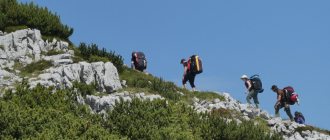
How to get to Mount Kachkanar?
By car, leave the city of Yekaterinburg on the Serovsky tract. Turn onto Nizhnyaya Tura, drive through this city and move to the village of Kosya. Or you can turn a little earlier to Kachkanar and shortly before entering the city turn to Kosya. The distance here is closer, but the road is worse. You can also get there by public transport: by intercity bus from Yekaterinburg to Nizhnyaya Tura, and then by commuter bus to the village of Kosya (checking the current schedule in advance). The forest road to the mountain begins in the north-eastern part of the village of Kosya - at the beginning of Gornaya Street. Walk about 6 km. First the monastery will appear, and then the rocks begin. People go to the mountain all year round.
From the city of Perm by car you need to go through the cities of Chusovoy, Gornozavodsk, turn to Kachkanar and then to Kosya. Distance from Yekaterinburg – 270 km, from Perm – 300 km, from Chelyabinsk – 500 km.
GPS coordinates of Mount Kachkanar: N 58° 46.637´; E 59° 23.196´ (or 58.777283°, 59.3866°).
Previously, it was possible to get to the mountain from the side of the city of Kachkanar - through the territory of the Kachkanarsky Mining and Processing Plant (bypassing the booth with security guards), but now they are not allowed there.
A trip to Kachkanar can be combined with a visit to the rocks on Mount Kolpaki and the site where the first diamonds were found in the village of Promysla. When traveling around the Urals, take care of nature!
Pavel Raspopov
Sources: Arkhipov Alexander. Monk // AiF-Ural" No. 39, 2003. EVRAZ has cleared the site for a new quarry on Mount Kachkanar - Znak, 10/14/2019. Matveev A.K. Geographical names of the Sverdlovsk region. – Ekaterinburg, 2007. Rundkvist N.A., Zadorina O.V. Sverdlovsk region. From A to Z: Illustrated encyclopedia of local history. - Ekaterinburg: “Kvist”, 2009. Website Shedrub Linga Titovets M. Historical Kachkanarology. – Kachkanar, 2005.
It is important to know
Limitations and Features
Our version of the route involves an ascent from Kosya, the route passes through the monastery, the Camel rock, to the Northern peak. From the Northern peak, take a radial exit of half a kilometer to the Rocket monument, and then traverse from the Northern peak, through the saddle to the Southern one. From the southern peak there is a descent to the Kachkanar pond, and from there it’s a stone’s throw to the city of Kachkanar.
No specialized equipment is required to visit the route.
You can walk to the monastery and the Camel rock from Kosya all year round. Getting to the northern peak is already more difficult; in winter there is not always a path to it, but if you have tourist skis and a little experience, getting to it will not be difficult. It’s the hardest time in the off-season, when the snow melts and hidden crevices and large kurum pose a great danger. The traverse from the northern peak to the southern one is safe and easy to walk only in the summer.
When planning a route, you should also take into account that the Urals are unpredictable and it is advisable to check the weather in advance and plan equipment and protection from weather conditions. In summer you need to be careful with drinking water; you simply won’t find it at the top. In general, the rest is an ordinary route, walking, not particularly difficult for an experienced tourist.
In case of an unforeseen situation, help can be sought in the Shad Tchup Ling monastery, the village of Kosya or in the city of Kachkanar. All of them are reached either by trails or roads. There are a lot of people walking to the Northern Peak, the camel, the rocket, the monastery, and there are more chances of escape. But between the peaks and on the southern peak there are many fewer people. There is no first aid post in the village of Kosya. Almost the entire top of the mountain has cellular coverage.
One way or another, before completing the route, it is better to register with search and rescue teams or the Ministry of Emergency Situations!
How to get there
Mount Kachkanar is located near the city of the same name in the Sverdlovsk region, approximately 260 kilometers from Yekaterinburg.
The starting point of our route (N58°47'50.96″ E59°21'14.80″) is the bus stop in the village of Kosya.
You can get here either by bus, which runs twice a day from the Nizhnyaya Tura bus station at 11:00 and 18:10, or by private car, but then you will have to hitch a ride from the city of Kachkanar, where the route ends.
Railway transport and other alternative transport to the village. There is no mow.
You can leave the city of Kachkanar by bus. The bus station is indicated on the printable map and Nakarte.tk
The current public transport schedule can be found on the Yandex website.
Places for rest and overnight stays
There is a gazebo at Camel Rock. This is a good place to stop and have lunch.
At the Northern peak there is a fork - down the slope after 15 meters there will be a good clearing for spending the night, and after 500 meters there will be a monument to Gagarin - “Rocket” and a luxurious clearing for spending the night with a wooden table and seats.
There are also good parking spots near the South Peak, but it should be taken into account that it is a crowded place and Kachkanar residents often rest.
Water
There is almost no water on the mountain, except in puddles under huge stones and then it needs to be boiled. Take sufficient supplies of water with you.
The shops
The nearest store is only in Kosya or Kachkanar.
There are no shops along the route. Make all necessary purchases in advance.
Don't forget to take it with you
- Supplies of food and drink.
- Suitable clothing.
- Personal and group equipment.
- First aid kit.