Sovetsk
(Kirov region)
OKATO code:
33236501
Founded:
1594
City since:
1937 City of district subordination (Sovetsky district, Kirov region)
Center:
Sovetsky district
The city was formerly called:
| crow | 1594 | 1918 |
| Telephone code (reference phone) | |
| 83375***** | 12-2-22 |
Deviation from Moscow time, hours:
0
Geographic latitude:
57°35′
Geographic longitude:
48°57′
Altitude above sea level, meters:
100 Sunrise and sunset times in the city of Sovetsk
History of the area
- general information
- Story
- Symbolism
- District Charter
- News bulletin
- Famous fellow countrymen
- Economy
- Economy
- Municipal programs Development of education
- Formation of a healthy lifestyle
- Development of the social sphere
- Ensuring public order and crime prevention
- Development of municipal budgetary institutions subordinate to the Department of Culture and Social Work of the Sovetsky District Administration
- Development of the agro-industrial complex
- Development of municipal government
- Management of municipal finances and regulation of interbudgetary relations
- Energy saving and increasing energy efficiency
- Development of the transport system
- Development of public infrastructure systems
- Management of municipal property and land resources
- Providing housing for young families
- Housing development
- Small business Small business Small business
- Normative legal acts
- Normative legal acts
- Healthcare
- General information General information General information
- general information
- Mass media
Information for the public
- Protection of the population and territories from emergency situations
- Healthy lifestyle
- Crime prevention
- Land plots and municipal property
- Client service of the Pension Fund in the Sovetsky district
- The Federal Tax Service
- Prosecutor's Office of the Sovetsky District
- Inspectorate of Gostekhnadzor of the Sovetsky district
- KOGBU "Soviet Interdistrict SBBZH"
- NPO "Capital Repair Fund"
- Department of Housing and Utilities
- Free legal assistance
- Consumer rights Protection
- Open data
- Information to be presented using coordinates
- Passenger Transportation
- Register of container sites
- Useful phones
Important links
Map
| Sovetsk: maps |
Sovetsk: photo from space (Google Maps) Sovetsk: photo from space (Microsoft Virtual Earth)
| Soviet Nearest cities. Distances in km. on the map (in brackets along roads) + direction. Using the hyperlink in the distance , you can get the route (information courtesy of the AutoTransInfo website) | |||
| 1 | Pizhanka | 28 (34) | SW |
| 2 | Lebyazhye | 40 (38) | SE |
| 3 | Arbazh | 40 (80) | Z |
| 4 | Verkhoshizhemye | 47 (52) | WITH |
| 5 | Nolinsk | 58 (114) | IN |
| 6 | Pushing | 59 (99) | Z |
| 7 | New Toryal (Republic of Mari El) | 66 (74) | YU |
| 8 | Yaransk | 71 (78) | SW |
| 9 | Suna | 71 (90) | IN |
| 10 | Sernur (Republic of Mari El) | 73 (100) | YU |
| 11 | Kumeny | 81 (179) | NE |
| 12 | Urzhum | 81 (88) | SE |
| 13 | Kuzhener (Republic of Mari El) | 85 (107) | YU |
| 14 | Kotelnich | 87 (101) | NW |
| 15 | Orichi | 91 (104) | WITH |
| 16 | No | 91 (144) | IN |
| 17 | Soviet (Republic of Mari El) | 96 (115) | YU |
| 18 | Mari-Turek (Republic of Mari El) | 96 (137) | SE |
| 19 | Orshanka (Republic of Mari El) | 97 (129) | SW |
| 20 | Paranga (Republic of Mari El) | 101 (134) | YU |
| 21 | Orlov | 105 (148) | WITH |
| 22 | Kiknur | 108 (120) | Z |
| 23 | Bogorodskoye | 110 (153) | IN |
| 24 | Candle | 114 (141) | NW |
| 25 | Tonshaevo (Nizhny Novgorod region) | 116 (205) | Z |
| 26 | Semyonovka (Republic of Mari El) | 119 () | SW |
| 27 | Kirov | 120 (129) | WITH |
a brief description of
Located on the high right bank of the river. Pizhma, 4 km from its confluence with Vyatka, where the pier is located, 103 km south of the railway. Kotelnich junction, 140 km south of Kirov.
Territory (sq. km): 26
Information about the city of Sovetsk on the Russian Wikipedia site
Historical sketch
Founded in 1594 (according to other sources, around 1609) on the lands of the Mari-Cheremis as the settlement of Kukarka. The settlement consisted of several courtyards around a wooden church, surrounded by a high palisade and a deep ditch. The main occupation of the residents was agriculture and the supply of grain to Western Siberia. In 1620, the settlement had 63 courtyards, a church, 2 forges, 2 water mills.
In the 18th century Academician G.F. Miller associated the oikonym with the Udmurt kar “city”; in the 20th century it has been suggested that it is connected with slash-and-burn agriculture: the Turkic-Bulgar kukar “burnt out place, burning place.”
In the 18th-19th centuries. Kukarka is a large craft and trade center in the Vyatka province. Carpentry, the manufacture of carts and sleighs, were developed, and flask stone was mined, from which grinding stones, wheels, and millstones were made. Sloboda was famous for lace making (a school of lace makers since 1893), fulling and pottery production.
In 1870, there were 5 churches in the settlement, and there were 65 stone and 75 wooden shops. A power station was built in 1910, and a telephone appeared in 1911.
In 1918, by decision of the Vyatka Provincial Executive Committee, the Kukarka settlement was renamed the city of Sovetsk. However, in 1931 it was listed as the village of Sovetsk. City of Sovetsk since 1937
Economy
Meat processing plant, butter factory, food processing plant. Factories: for the production of felted shoes, a glove factory, a branch of the Kirov factory of stitching and lace products. Woodworking plant. Elevator.
In the vicinity of Sovetsk there is mining of crushed stone.
In the Sovetsky region, rye, wheat, barley, oats, potatoes, and vegetables are grown. They raise cattle, pigs, and sheep. Poultry farming.
Deposits of rubble stone, crushed stone, limestone, sand, gravel, marl, peat.
Culture, science, education
Museum of Local Lore.
Museums, galleries, exhibition halls
Sovetsky District Museum of Local Lore 613340, Kirov region, Sovetsky district, Sovetsk, sq. Malkova, 6 Phone(s): (83375) 2-2497
Architecture, sights
Church of the Intercession (early 17th century), Lebedeva's house (19th century).
Until the 1970s wooden manor-type houses predominated in the city.
In 1990, a bridge was built across the Vyatka River.
In the Sovetsky region there are caves: Zaramenskaya, Paradnaya, Kholodnaya, Sofronovskaya and others.
| Population by year (thousands of inhabitants) | |||||||
| 1939 | 10.8 | 1996 | 18.8 | 2007 | 16.5 | 2015 | 15.7 |
| 1959 | 14.6 | 1998 | 18.9 | 2008 | 16.2 | 2016 | 15.7 |
| 1967 | 17 | 2000 | 18.7 | 2010 | 15.8 | 2017 | 15.6 |
| 1970 | 17.0 | 2001 | 18.4 | 2011 | 16.6 | 2018 | 15.5 |
| 1979 | 18.4 | 2003 | 18.2 | 2012 | 16.4 | 2019 | 15.4 |
| 1989 | 19.4 | 2005 | 17.2 | 2013 | 16.2 | 2020 | 15.2 |
| 1992 | 19.1 | 2006 | 16.8 | 2014 | 15.9 | 2021 | 15.1 |
Sovetsky district is located in the southwestern part of the Kirov region. In the west it borders with the Arbazhsky and Pizhansky districts, in the east with the Nolinsky and Lebyazhsky districts, in the north with the Verkhoshizhemsky district, and in the south with the Republic of Mari El. The administrative center of the district is the city of Sovetsk, whose territory is 2411.1 sq. km. The distance from Sovetsky to Kirov is 140 km. The first mention of the Kukarka settlement (as the city of Sovetsk was previously called) dates back to 1594. On August 9, 1918, on the initiative of the founder of Soviet power in the settlement and the surrounding villages, Mikhail Ivanovich Izergin, the Kukarka settlement was renamed the city of Sovetsk and the Sovetsky district was formed. And in 1929, the Sovetsky district of the Vyatka province was formed. The boundaries of the district have changed several times. Folk crafts have long been developed in the region: carpentry, stone-making, bell casting, and pottery production. Kukar lace was famous throughout Russia, winning awards at international exhibitions more than once. The products of Kukar stone-cutters were widely known, since the extraction of flask stone was one of the main trades. The territory of the Sovetsky district is a ridged-hilly plain with a decrease in altitude to the south and east, cut by deep ravines and rivers, and covered with a network of rivers. The largest of them are Vyatka, Pizhma, Nemda. The commercial ichthyofauna of Vyatka and Pizhma is represented by 17-18 species of fish, the most valuable of which are sterlet, asp, catfish, carp, and carp. Pike, pike perch, ide, chub, burbot, asp, perch, ruff, silver bream, and saberfish are common. Due to their small size and hidden lifestyle, spined loach and sculpin are rarely found. The number of catfish and podust is low. From floodplain and subsidiary reservoirs, rudd, tench, gold and silver crucian carp, and loach enter the rivers. River galyan and grayling live in the channels. Crayfish are common. The banks of the rivers are picturesque, attractive and serve as a recreation area for the population. The rivers are little used for water sports and tourism. Water transport is poorly developed. The Vyatka River is navigable only during the spring flood period. The forests of the region are rich in wild plant materials (berries, mushrooms, medicinal plants) and game animals. Here you can find elk, wild boar, bear, wolf, hare, beaver, marten, otter, fox, raccoon, badger, squirrel, lynx, muskrat, mink, wood grouse, black grouse, hazel grouse and waterfowl characteristic of central Russia. Recently, there has been a tendency for the number of main game animals to increase. There is a tendency for new game animals to increase their numbers, wolf, hare, beaver, marten, otter, fox as hunting animals. Due to the presence of limestones, there are many karst-suffusion sinkholes of varying depths and caves. Nowadays, the surroundings of the former village of Chimbulat are very popular among nature lovers. People come here not only to admire the unfading beauty of nature. Climbers conduct training and competitions of international level on steep banks. Visiting the caves discovered in these places in 1974 has become traditional for novice speleologists. In total, there are 17 natural monuments on the territory of the Sovetsky district: - the Pizhemsky state nature reserve, operating since 2002. — Rock massif “Stone”. It is part of the Pizhemsky state nature reserve. — Chimbulat botanical-geological complex. It is part of the Pizhemsky state nature reserve. — Beresnyatsky botanical-geological complex. It is part of the Pizhemsky state nature reserve. Includes 5 more natural and archaeological monuments (BURZHATSKY CLIFK, NIZHNEVODSKY FORTELOGY, LIMESTONE ROCK outcrops, WALL, BERESNYATSKY WATERFALL). — Zaramenskaya cave. It is part of the Pizhemsky state nature reserve. — Bykovshchinskoye Lake, a state natural monument of regional significance. - Suvodsky Bor - Lily of the Valley Forest - Giant larch - Tree-like junipers - Springs not far from the village of Borok - Tsarsky Klyuch, a natural monument located in Suvodsky Bor Source: official website of the Kirov region
Sovetsk (city in Kirov region)
| The section lacks links to sources. Information must be verifiable or it may be deleted. You can |
First Founders
The Vyatka River near the city of Sovetsk, August 2010,
III century. BC e. until the X-XI centuries. n. e.
According to archaeological excavations, people lived in these places since ancient times; in the nearest suburb (6 km from the modern city of Sovetsk) there is a Pizhemskoye settlement (Ananyinskaya culture), it was constantly inhabited until the 11th century.
Versions of the emergence of a settlement on the site of modern Sovetsk:
— Bulgarian version
, based on the Bulgar etymology of the name Kukarka, suggests the founding of a settlement at the mouth of the Kukarka River by the Bulgars.
— Mari version
— the settlement was founded in ancient times by the Mari as the Kukarka fortress.
XII century
Kukarka becomes the princely residence of the legendary Prince Chumbylat, a national hero and “king” of the Mari, who united the Mari tribes under his rule.
According to legend, Chumbylat was a great warrior, built cities, developed crafts and arts. He was received by the rulers of the East. Under him, the tradition of worship of the Mari faith developed; he is a legendary saint of the Mari religion. In the vicinity of Sovetsk there is Mount Chumbylat ( Chumbylatov stone
, mar. Chumbylat kuryk) - a limestone cliff of Vyatsky Uval on the right bank of the Nemda River, a revered pagan shrine of the Mari, the legendary grave of the Mari prince Chumbylat.
Russian kingdom
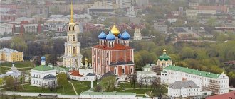
Church of the Intercession, the oldest surviving building in the city, 17th century.
Photo from 2022. 1594
, during the annexation and development of the Mari region, during the reign of the Tsar and Grand Duke of All Rus' Fedor I Ioannovich, the Russian settlement Kukarka was formed on the site of the Mari settlement, as stated in written records: “It consisted of several courtyards around a wooden church, surrounded a high palisade and a deep ditch. Residents were mainly engaged in farming and supplying grain to Western Siberia, owned fishing and beaver runs on the Vyatka from the mouth of Pizhma to Seldyuga, up the Nemda from the mouth to the Gremachi River and 20 versts up the Pizhma.” Kukarka became one of the links in the chain of newly built forts with garrisons of archers: Sanchursk, Yaransk, Kukarka, Urzhum, Malmyzh to maintain order and adherence to the law among the Mari and Votyaks.
1594
, Zhernovogorskaya Predtechenskaya Hermitage (monastery) was founded.
1608
, the residents of Kukarka supported the rebels dissatisfied with the rule of the Tsar and Grand Duke of All Rus' Vasily IV Shuisky. The rebel Mari and Russian peasants attacked the Zhernovogorsky Predtechensky Monastery and plundered it.
1609
, An army from Kazan under the leadership of Istoma Khvostov defeated the rebels and burned the rebellious Kukarka. The Zhernovogorsky Predtechensky Monastery was transferred to the Kukarka settlement under the protection of the fort and became the basis for the Kukarsky Pokrovsky Monastery.
1619
, a handicraft industry was developed for the extraction and processing of flask stone (income came to the monasteries in the form of rent, according to the charter of the Patriarch of Moscow and All Rus' Filaret).
1637
, from the Order of the Kazan Palace, from January 1637, Andrei Zhitkov was ordered to be an orderly person at Kukarka [4]. In the 17th century there was an official hut and a yard here.
1639
, The Sovereign’s decree read: “... it was ordered that their insufficient peasants in the sovereign’s Kukarskaya settlement be invited to empty places for benefits.”
1678
, Kukarsky Assumption Convent was founded.
1684-1695
- the center of Kukarsky district.
1690s
— the stone building of the Intercession Church of the Kukar Pokrovsky Monastery was built (the building has survived to this day).
Russian empire
Sloboda Kukarka on the map of Vyatka Province, 1822.
XVIII-XIX centuries
, the Kukarka settlement was a craft and trade center of the Vyatka province, where carpentry, the production of carts, sleighs, and wicker baskets were developed. Sloboda was famous for lace-making, fulling and pottery production.
1729
The clerk's hut was renamed into the office of administrative affairs.
Rural Bulletin, 1882. No. 02 on p. 23 In trade news, a comparison of trading prices in the Kukarki settlement is on a par with large shopping centers in Russia.
September 11, 1780
, the Vyatka governorate was established by the Supreme Decree of the Empress of All-Russia Catherine II the Great (December 31, 1796 transformed by the Supreme Decree of the Emperor of All-Russia Paul I into a province), the settlement of Kukarka entered the Yaransky district.
1797
, By the Highest Decree of the All-Russian Emperor Paul I, special orders were established for the rural management of palace estates, Kukarka became the administrative center of the appanage order.
1839
, a hospital is open.
The first graduate of the Suvod Forestry School, 1898.
Populated areas of the Russian Empire with 500 or more inhabitants (1897 census) ed. 1905, Population sl. Crow on page 40. 1840
, the first educational institution was opened - a one-class men's school.
Trinity Cathedral in Kukarka.
Photo from 1910 (destroyed in 1935). 1860
, a commercial and industrial loan bank and a women's school were opened.
1861
, as a result of the Peasant Reform of Alexander II, the Kukarka settlement became the administrative center of the Kukarka volost of the Yaransky district, P.V. Alabin opened a public library in Kukarka. An almshouse has been opened in the settlement.
The beginning of steamship traffic along the Vyatka River, the settlement of Kukarka becomes one of the most important piers on the Vyatka River.
1862
, a post office is open.
1869
, the Church of the Savior was built, a forest school was opened.
October 8, 1880
, the telegraph station began to operate.
1887
, from the article “Travel Sketches” by N. Mirolyubov (pseudonym) in the newspaper “Volzhsky Vestnik”, Kazan, “... Kukarka gives the impression of a very decent county town and is superior in attitude to a good half of our county towns. I was told that there was even a petition to rename Kukarka to the city of Aleksandrovsk; the inhabitants of Yaransk themselves claimed that this district town was worth nothing in comparison with the Kukarskaya settlement included in its district...”
1893
— the House of Diligence, the lace-making school, and the club (public meeting) are open.
Sloboda Kukarka on the map of Yaransky district, 1891.
1896
— Suvod Forest School was opened.
1897
According to the first general census of the Russian Empire, there were only 5,242 people in the Kukarka settlement, including husband. — 2526 people, women. - 2719 people, Orthodox population 5159 people. (COLLECTION: Populated places of the Russian Empire with 500 or more inhabitants (census of 1897), ed. 1905, population of the village Kukarka, p. 40).
Early 20th century
, in the Kukarka settlement there were 5 stone churches, a telegraph station, a power station, 2 libraries, and a local history museum. In terms of the number of educational institutions, not every county town could compare with Kukarka: in 1910 there were 3 elementary schools, a parochial school, a model school at the teachers' seminary, a city school, a women's gymnasium, and a teachers' seminary. There were 65 stone and 75 wooden shops. In terms of population, the presence of stone houses, landscaping, trade and crafts, the Kukarka settlement was superior to neighboring district towns. From the notes of N. Zolotnitsky “A brief sketch of the settlement of Kukarka”, “... In terms of population, Kukarka exceeds Urzhum, Malmyzh, Glazov, Yaransk by 1188 people. There are more than 20 stone houses, a stone row of shops, many half-stone houses, and most of the wooden ones are on a stone foundation or on stones. In general, in Kukarka there are not at all those wretched shacks that fill the provincial towns, and many of the houses in size and architecture, with sidewalks made of wild and flask stones, could serve as an adornment to a provincial town.”
April 1901
, a veterinary department was opened, under the leadership of veterinarian M.V. Kurbanovsky.
1903
, a teachers' seminary was opened.
1905
, a fire station was built.
1908
, a city school was opened.
1909
, merchants D. D. Yakimov and K. K. Perminov organized the Kukar Electric Partnership.
1910
The Kukar Electric Partnership built the first power plant, which operated until 1960.
January 1910
, the Kukar Educational Society was organized.
June 1910
, the Motherland History Museum has been opened.
Paving of streets and courtyards with stone began, the first to be paved was Kazanskaya Street (now Lenin Street).
1911
, “Kukar Electric Partnership” built a telephone exchange.
1912
, the first cinema was built - “Electrotheater”, located on the site of the modern House of Culture.
April 1916
, the Consumer Society was formed.
Russian Soviet Federative Socialist Republic
December 27, 1917
, in the settlement of
Kukarka,
Soviet power was proclaimed by Cherepanov S.M.
January 1918
, Mikhail Ivanovich Izergin returns to
Kukarka
from the front and is elected chairman of the revolutionary committee.
In connection with the development of industry, on the initiative of M.I. Izergin and at the request of residents, the question of renaming the Kukarki
into the city
of Sovetsk
and the formation of the Sovetsky district is being raised.
March 25-27, 1918
, the first district congress of Soviets takes place. M.I. Izergin was elected chairman of the executive committee.
August 9, 1918
, by decision of the Vyatka provincial executive committee,
the Kukarka
was transformed into the district town
of Sovetsk
, with eight volosts.
Sovetsk
becomes the center of the Sovetsky district. Light and food industry enterprises are being created in the city, timber and stone processing plants are being built, consumer cooperation is developing and strengthening. The Yaransky district executive committee strongly opposed the formation of the Soviet district and even made a decision to abolish the Kukarsky district council, but the Soviet district existed for 6 years.
August 1918
, the party structure of the RCP (b) was created and an emergency commission (Cheka) was organized under the leadership of A.I. Krupin.
September 1918
, a conspiracy was uncovered about an uprising of merchants and Socialist Revolutionaries in
Sovetsk
to overthrow Soviet power. The most ardent counter-revolutionaries were shot.
September 19, 1919
, a resolution of the NKVD finally formalized the formation of the Soviet district - an administrative-territorial unit of the Vyatka province, with the center of the district in the settlement of
Kukarka
, officially renamed the city of Sovetsk.
May 7, 1920
, a library of the citywide youth union (children's library) was opened at the public library in the city of Sovetsk.
Union of Soviet Socialist Republics
1923
, the city's population was 6,784 people.
1924
, the widespread consolidation and liquidation of newly created territorial entities began. Yaransk stood for the liquidation of the district and the return of the former Kukarka to its command; the trip of representatives to Moscow did not help to defend the district. And Sovetsk turned into the center of the enlarged volost of Yaransky district. The printing house and other property were taken to Yaransk.
1925
, after some turns in the country's economy, the slogan “Facing the Countryside” was put forward, with tax cuts for rural areas.
Former Kukar townsfolk, who after the liquidation of the district became the leaders of public opinion, brought the city economy into decline and petitioned that since the Sovetsky district was liquidated, they wished to transform the city of Sovetsk back into a rural area. There were requests, in addition to classifying the settlement as a rural area, to rename it the village of Rykovo
(part of the revolutionary A.I. Rykov)[5].
As a result, the residents' request was granted and Sovetsk
became the village
of Sovetskoye
.
1926
, a radio was sent to the village of Sovetskoye. The population dropped sharply to 4,794 people; due to the liquidation of the district, the vast majority of former employees of district institutions and organizations left with their families; in addition, at this time people who had been evacuated from the capitals in 1918 returned to Moscow and Leningrad.
1928
, in the village of Sovetskoye, doctor V.K. Vetoshkin headed the anti-tuberculosis service.
January 14, 1929
, by a resolution of the All-Russian Central Executive Committee of the RSFSR, the Vyatka province and all its districts were abolished, and their territory became part of the Nizhny Novgorod region of the RSFSR[6]. With the disaggregation and abolition of districts, the Sovetsky district was formed as part of the Kotelnichesky district of the Nizhny Novgorod region, the village of Sovetskoye became the center of the Sovetsky district, from a village transformed into the village of Sovetsk with a village council.
1929
, the House of Culture is opened.
February 1930
, the Urban Consumer Society (GorPO) was formed, but unlike the pre-revolutionary one, already according to the laws of the new socialist country.
1930
, the first water supply for public baths appeared. At the same time, the Assumption Church was closed and a hydroelectric power station was launched on the Nemda River.
June 1, 1931
, the Soviet tuba sanatorium was opened.
September 6, 1931
, the library of the citywide youth union was reorganized into the Soviet regional children's library.
1931
, the Ilyinskaya Artel emerged from the Soviet lace artel. At the same time, a new educational building of the Suvod Forestry College was built.
October 7, 1932
, in connection with the renaming of Nizhny Novgorod to
Gorky
, the Nizhny Novgorod region was renamed
Gorky
.
The village of Sovetsk becomes the center of the Sovetsky district as part of the Kotelnichesky district of the Gorky Territory. The city of Sovetsk on the map of the Kirov region, 1935
December 7, 1934
, simultaneously with the renaming of the city of Vyatka to Kirov, the Kirov Territory was separated from the territory of the Gorky Territory, which included the village of Sovetsk as the center of the Sovetsky District.
December 7, 1936
, on the eve of the adoption of the Constitution of the RSFSR of 1937, the regional division in the RSFSR was eliminated, the Kirov Territory was renamed the Kirov Region, and the village of Sovetsk remained in it as the center of the Sovetsky district.
February 9, 1936
, a pioneer club (House of Pioneers) was opened.
February 14, 1936
, a self-supporting music school was opened, classes were held in the buildings of secondary schools, organized by violinist Yuri Ezhov.
March 1936
, the Soviet road maintenance section No. 219 was formed (currently KOGP Vyatavtodor Sovetskoe DU-36).
Autumn 1939
, in connection with the approaching 50th anniversary of the birth of the Chairman of the Council of People's Commissars of the USSR
Vyacheslav Mikhailovich Molotov
, a native of Kukarka, Sovetsk was re-transformed into a city with the inclusion of the village of Zhernovogorye, the regional anti-tuberculosis sanatorium, the Chernushinsky cordon, the forestry technical school and the recently opened 2nd timber mill.
1939
, a new building for the Luch cinema was built.
During the Great Patriotic War
1941
, the Soviet Music School was opened.
July 23, 1941
, the Soviet psychoneurological hospital opened.
at the end of August 1941
, the Bryansk Forestry Institute (now Bryansk State Engineering and Technology University) was evacuated to Sovetsk - it was located in the city until the liberation of Bryansk from German occupation;
in September 1941
, the Kalinin Regional Academic Drama Theater was evacuated to Sovetsk, in Sovetsk it opened with the play “Confrontation” by the brothers Tur and L. Shein, and only in January 1942 returned to liberated Kalinin;
in 1941
, the Dmitrov glove factory was evacuated to Sovetsk.
in 1942-1943
Two evacuation hospitals No. 4692 and No. 5799 were deployed in the city; they were located in the buildings of the pedagogical school.[7].
After the Great Patriotic War
1947
, The Church of the Intercession has been returned to the believers.
1957
, the building of the second cinema “Letniy” with 220 seats was built in the city garden. In the same year, the first reception of television programs from the Kirov Television Center began.
1960
, a city route for passenger ships opened along the beds of the Vyatka and Pizhma rivers passing through the city.
1961
, with the installation of the first water tower, a general city water supply appeared.
1962
, the airport building was built.
1964
, asphalting of city streets began, the first permanent wooden automobile bridge on reinforced concrete supports was built in the city across the Pizhma River, and the third cinema was built in the Zhernovogorye microdistrict.
1965
, we installed our own TV repeater.
February 3, 1966
, organizing a station on herbs (“Dimetra”).
1967
, gasification of apartments has begun.
1968
, the Pechenkino microdistrict entered the city limits, construction of the city sewerage system began, the third Druzhba cinema was built, regular intercity flights of high-speed planing passenger ships "Zarya" with water-jet propulsion began.
September 1, 1968
, a monument to Soviet soldiers was unveiled.
April 22, 1970
, a monument to the leader of the October Revolution, V. I. Lenin, was unveiled.
1971
, on the site of the previously destroyed Spaska Church, the building of the Kukarka cafe was built.
1976
, a new reinforced concrete bridge was built across the Pizhma River in the city. The Soviet regional children's library is included in the Soviet centralized library system and becomes the Central Children's Library.
1977
, a new building of the House of Culture was built, with an auditorium for 500 seats.
1980
, the first large-panel house was built, new hospital buildings were built, its bed capacity increased to 350 beds.
February 23, 1981
, the sports complex was inaugurated at the Suvod Forestry Technical School.
1985
, a second reinforced concrete pedestrian bridge across the Pizhma River was built in the city.
1986
, the city built a modern, at that time, standard four-story clinic building for 375 visits per shift.
Bus station in Sovetsk.
Photo from 2010. 1980-1990
— the highest rise and development of the city’s infrastructure. The city's population grew to almost 20 thousand people. There was an airport that received Yak-40, An-24, An-2 aircraft, making interregional and intraregional flights. The pier with a waiting room regularly received intra-regional flights of high-speed passenger ships "Zarya", and a permanent urban route of passenger ships operated along the beds of the Vyatka and Pizhma rivers passing through the city. The bus station received intra- and interregional flights of LAZ-699 “Tourist” and Ikarus-256 buses and intra-district flights of LAZ-695 and PAZ-672 buses; LiAZ-677 buses operated on three city routes. Six vocational education institutions were located in the city: Suvod Forestry Technical School, Soviet Pedagogical School, Soviet Medical School, City Vocational Technical School No. 17, Rural Vocational Technical School No. 39, Vocational School No. 28. There were three cinemas: “Luch”, “ Rainbow" and "Summer". Five crushed stone-lime quarries were under development: Suvodskoy, Popovetsy, Kremeshkovsky, Chimbulatsky, Beresnyakovsky, transportation of stone and soil was carried out by heavy-duty dump trucks: BelAZ-548A, BelAZ-540A, Tatra 148, MoAZ-6014, KrAZ-256B.
December 1990
, a reinforced concrete bridge was built in the city across the Vyatka River.
Russian Federation
1991
, Sovetsk airport was liquidated.
April 27, 1998
, created by KOGOBU "Lyceum of Sovetsk", an institution of the third level of education in physics, mathematics and socio-economic profiles.
January 25, 2001
, reorganization of SPTU No. 39 into KOGPAU “Technical College of Industry and Folk Crafts of Sovetsk”.
January 1, 2007
, created by KOGPOBU "Industrial Pedagogical College of Sovetsk", by combining the Soviet Pedagogical School and Vocational School No. 28.
December 22, 2009
, there was a reorganization of the State Educational Institution of Secondary Professional Education “Soviet Medical School” in the form of joining the KOGBOU Secondary Professional Educational Institution “Kirov Medical College” branch in Sovetsk.
February 2010
, a Unified Dispatch Service was created
year 2012
, the branch in Sovetsk of KOGBOU SPO “Kirov Medical College” was liquidated.
August 8, 2014
, KOGBUZ "Soviet Psychiatric Hospital" was reorganized by forming the Soviet branch of KOGBUZ "Kirov Regional Clinical Psychiatric Hospital named after. Academician V. M. Bekhterev."
year 2014
, by decision of the Soviet District Duma, the District Children's Library was named after a native of Sovetsk, writer Boris Aleksandrovich Porfiryev.
April 2015
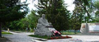
, on the initiative of veterans of the Great Patriotic War and the first secretary of the Kirov regional committee of the Communist Party of the Russian Federation, deputy of the State Duma of the Federal Assembly of the Russian Federation of the sixth convocation Sergei Pavlinovich Mamaev, a memorial composition “For the Soviet Motherland!”
- T-80B tank. “Smolentsevsky Key”, consecrated in the name of the Smolensk Icon of the Mother of God, after reconstruction.
Photo from 2022. 2016
, a new sports and recreation complex “Trokhrechye” was put into operation.
2017
, reconstruction and construction of a complex of chapel buildings at the Smolentsevsky Key springs, consecrated in the name of the Smolensk Icon of the Mother of God
November 1, 2022
, the Yubileiny park was built and opened, with the stele “I love Sovetsk”.
2018
, a new complex of the Sweet Sloboda confectionery factory was built.
December 29, 2022
, the cinema "PARUS" is open.
Modern times
, — in Sovetsk there is a food processing plant, a meat processing plant, a glove factory, a woodworking plant and many small woodworking enterprises, and an elevator. Crushed stone is mined in the vicinity of the city (2 quarries are in development).
Links[edit]
Notes[edit]
- ^ abcdefgh Law No. 203-ZO.
- ^ a b E. M. Pospelov. "Geographical names of the world." Moscow: Russian dictionaries, 1998, p. 389.
- ^ a b Federal State Statistics Service (2011). “All-Russian Population Census 2010. Volume 1" [All-Russian Population Census 2010, vol. 1]. All-Russian Population Census 2010 [All-Russian Population Census 2010]
. Federal State Statistics Service. - "26. The size of the permanent population of the Russian Federation by municipalities as of January 1, 2022". Federal State Statistics Service. Retrieved January 23, 2022.
- ^ abcde Law No. 284-ZO
- "On the Calculation of Time". Official Internet portal of legal information
. June 3, 2011. Retrieved January 19, 2022. - Post office. Information and computing center of OASU RPO. ( Post office
).
Search for postal service objects ( postal Search for objects
) (in Russian) - ↑
Federal State Statistics Service of Russia (May 21, 2004).
“The population of Russia, the constituent entities of the Russian Federation as part of federal districts, urban settlements, settlements, settlements of 3 thousand or more people” [Population of Russia, its federal districts, federal districts, districts, urban settlements, rural settlements - administrative centers and rural settlements with a population of more than 3,000 people] (XLS). All-Russian Population Census 2002
. - “All-Union Population Census of 1989. The current population of union and autonomous republics, autonomous regions and districts, territories, effects, urban settlements and rural district centers” [All-Union Population Census of 1989: current population of union and autonomous republics, Autonomous regions and districts, territories, regions, districts, urban settlements and villages performing the functions of district administrative centers. All-Union Population Census of 1989 [All-Union Population Census of 1989]
.
Institute of Demography of the National Research University: Higher School of Economics [Institute of Demography of the National Research University: Higher School of Economics]. 1989 - via Demoscope Weekly
.
Sources [edit]
- Legislative Assembly of the Kirov region. Law No. 203-ZO of December 4, 2007 “On the register of administrative-territorial units and settlements of the Kirov region,” as amended. Law No. 350-ZO of November 11, 2013 “On amendments to certain Laws of the Kirov Region.” Came into force after ten days from the date of official publication. Published: “Vyatka Territory”, No. 227 (4115), December 11, 2007 (Legislative Assembly of the Kirov Region. Law No. 203-ZO of December 4, 2007 “ On the register of administrative-territorial units and settlements of the Kirov Region”,
as amended , introduced by the Law of November 11, 2013 No. 350-ZO “
On Amendments”).
Various laws of the Kirov region ( come into force on the day following ten days after the day of official publication). - Legislative Assembly of the Kirov region. Law No. 284-ZO of December 7, 2004 “On establishing the boundaries of municipalities of the Kirov region and granting them the status of a municipal district, city district, urban settlement, rural settlement,” as amended. Law No. 350-ZO of November 11, 2013 “On amendments to certain Laws of the Kirov Region.” Came into force after 10 days from the date of official publication. Published: “Vyatka Territory”, No. 233–234 (3401–3402), December 21, 2004 (Legislative Assembly of the Kirov Region. Law of December 7, 2004 No. 284-ZO “ On establishing the boundaries of municipalities of the Kirov Region and assigning them municipal district, urban district, urban settlement, rural settlement
as amended by Law No. 350-ZO of November 11, 2013
On amendments to various laws of the Kirov region
... Valid after 10 days from the date of official publication.).