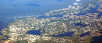
From other regions of Russia you can only get to Kamchatka by plane. Flights arriving in this beautiful region land at Elizovo International Airport, Petropavlovsk-Kamchatsky. Flying up to the capital of the region, you can see from above that the city is spread out quite widely on the shore of Avachinskaya Bay, which belongs to the Pacific Ocean. A majestic panorama opens up to your eyes, which will take your breath away: the city surrounded by mountains and water. Very close to Petropavlovsk-Kamchatsky rise the Avachinskaya and Koryakskaya hills, which are active volcanoes.
On the territory of the airport you can see the Li-2 aircraft, turned into a monument. This Soviet military transport ship was actively used in the 40s of the twentieth century, and during the war it worked a lot, transporting cargo. Elizovo was his Kamchatka base.
Location of Petropavlovsk-Kamchatsky
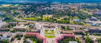
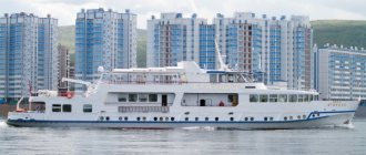
Petropavlovsk-Kamchatsky is the largest city on the map of Russia, located on the Kamchatka Peninsula. It is located on the shore of Avacha Bay, which is washed by the waters of the Pacific Ocean. Its area is about 400 sq. m, and the population is 181 thousand people. This is not only the administrative center of the Kamchatka Territory, but a large port city where the Russian Pacific Fleet is based.
The place is famous for various unique natural sites: geysers, volcanoes, thermal springs and nature reserves.
Administrative division
Initially, the small city did not have any division into districts. But during Soviet times, they tried to artificially divide the settlement into three districts. This innovation did not take root, and later the division was cancelled. Today the city consists of microdistricts through which people navigate in space.
The main streets of Petropavlovsk-Kamchatsky are Sovetskaya and Karl Marx Avenue. Many significant objects of the city are grouped around them. But in general, the settlement is very long, which sometimes poses a problem for residents who need to get to some remote places. The population density is 500 people per square meter. km.
Physiographic characteristics
A feature of the relief is constant ascents and descents, due to the large number of hills. The height difference from the lowest point to the highest is 513.6 m from sea level.
Petropavlovsk-Kamchatsky on the map of Russia is a zone of seismic activity of volcanoes, so small earthquakes are not uncommon here. Also frequent phenomena on the peninsula are: mudflows, snow avalanches, rising river levels, and heavy rains.
Petropavlovsk-Kamchatsky is a mountainous area surrounded by volcanoes
The time zone according to the international standard, called Kamchatka time, differs from Moscow time by a difference of +9 hours.
City infrastructure
Petropavlovsk-Kamchatsky was originally built without any plan, as a place of temporary residence, but its modern structure is not well thought out. When the settlement was small, it made no sense to divide it into districts. After the city grew, two districts were allocated, but this administration was soon abolished. Nowadays, Petropavlovsk-Kamchatsky is divided into several microdistricts. They were created taking into account the natural topography of the city.
The uneven terrain creates certain difficulties, since due to it the city is scattered over a large area, so getting from one area of the city to another can be difficult.
Public transport in the city is represented by buses. All routes lead to the Central District, which is very convenient given the sprawling location of the city. Most city residents have personal transport, but this causes a parking problem. There are few dedicated parking lots, so public spaces that are not intended for parking may be crowded with cars. The condition of the roads is not the best. Due to constant geological activity, even if it is not very pronounced, the asphalt cracks and fails...
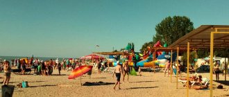
The development of tourism dictates its requirements for infrastructure. The need for good hotels, cafes, and restaurants is growing every day. What is offered in Petropavlovsk-Kamchatsky now is of a “normal” level, but there is always something to strive for.
Climate
The climate of Petropavlovsk is characterized by cool and changeable weather. The Pacific Current has a strong influence on weather variability; the maritime climate here is mixed with the monsoon.
Petropavlovsk-Kamchatsky on the map of Russia is located south of Moscow, at the same latitude as Bryansk, Tambov, Dublin and Manchester. A feature of the climate is strong cyclonic activity, bringing frequent storms, hurricanes and heavy rainfall.
The summer season is quite cool, the air temperature is slightly higher than in Magadan or Murmansk. In June the air warms up to +14 °C, and in July to +18 °C. The passing cold Kuril-Kamchatka Current often brings precipitation in the form of rain and fog.
The warmest month is August, the average temperature is +18 °C during the day and up to +10 °C at night, the water temperature in the sea reaches +14 °C. There are practically no hot days when the temperature rises above +20 °C, and if such weather does occur, it lasts no more than a week.
The warmest period accounts for the highest amount of precipitation; rain and thunderstorms are extremely rare, since moist air prevents thunderclouds from forming.
Autumn in Petropavlovsk begins quite abruptly and also ends abruptly. In September the average temperature is +14 °C, and in November it can drop to -1 °C. The first snow appears in September on the tops of the volcanoes and does not fall in the city until it covers the volcanoes completely.
In winter, the weather is affected by cyclones, so temperatures can change quickly. The city often experiences heavy snowfalls and cold winds. The average daily temperature in the winter months is -8 °C, with the coldest days occurring in January. The absolute minimum (-31 °C) was recorded in February 1917, and the maximum in July 2012 was +30 °C.
A large amount of precipitation falls annually, about 1200 mm.
Spring does not last long and often the cold returns again; the average temperature is slightly above +5 °C at the end of May.
History of the city and etymology of the name
The first Russian settlement appeared in the 17th century. On the shore of the bay, the Tsar's Cossacks founded buildings in which they stored furs collected as a tax from the local population. The founder of the city is considered to be officer I.F. Elagin. With his soldiers, he arrived on the coast of the peninsula in order to find suitable places for the wintering of large sea vessels.
On October 17, 1740, the ships of the Russian fleet officer V. Bering sailed to the shores of Kamchatka. They decided to name the founded fort Petropavlovsky, in honor of the ships of the Bereng expedition - “St. Apostle Peter” and “St. Apostle Paul”.
Almost 40 years later, English and French ships of famous sailors and travelers stopped off the shores of the fort. The main growth and development of the city began after Catherine the Great issued a decree on strengthening the distant borders of Russia. In 1812 the fort was renamed Peter and Paul Harbor.
In 1849, the Kamchatka region was formed, and Peter and Paul Harbor became the regional center. In 1851 the number of residents began to increase and after a few years there were 1,600 people. In 1924, the city began to bear the name Petropavlovsk-Kamchatsky.
Population
Petropavlovsk-Kamchatsky today has 180 thousand people. After perestroika, the city is going through hard times. If in 1991 there were 273,000 people living here, today the number of city residents is decreasing by at least 1 thousand every year. Despite a moderate increase in the birth rate and a decrease in mortality, it is not possible to stop the decline in the population. People are leaving the city due to the poor quality of life and declining economic indicators. The indigenous population of the region - the Kamchadals - is also gradually declining. Today there are just over 100 of them in the city.
Cultural and historical sights
- Nikolskaya Sopka. This natural monument is adjacent to Avacha Bay; it was from these places that the construction of the city began. In 1854, the city was defended against the Anglo-French enemy on it. On the hill, in honor of the fallen defense heroes, a monument in the form of a cast iron cannon was erected. In 1912, a chapel was installed on it; on one side there are the graves of the Russian defenders of the city, on the other, the graves of French and English sailors.
- Target hill. Most of the city is located on the slopes of Mishennaya Sopka, its peak is the highest point of the city. The features of its relief turned out to be unsuitable for construction, but its top was used to place an observation deck. From a height of 382 m you can admire views of the city, volcanoes or the Pacific Ocean.
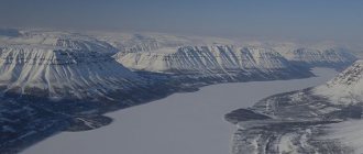
- Avacha Bay. Petropavlovsk-Kamchatsky on the map of Russia is located on the shores of Avachinskaya Bay, it is one of its main attractions. The bay is located off the southeastern coast of the peninsula. Its area is 215 sq. m, depth 26 m, and length 24 km. The bay dimensions allow it to accommodate cargo ships of any size.
- Monument to Peter and Paul. In the central part of the city in 2005, a bronze monument was erected to the patrons of the city - the apostles Paul and Peter. It depicts two apostles holding a cross between them, the height of the monument is 6 m. It was opened in honor of the 300th anniversary of Orthodoxy in Kamchatka.
- Monument to a grieving mother. Installed in 1975 before the celebration of Victory Day, the idea of creation belongs to war veteran P. Oshchepkov. The exhibit depicts a woman holding her children close to her. The monument is dedicated to the feat of all mothers whose sons valiantly defended their homeland from the enemy.
- Church of Peter and Paul. The history of the creation of the church begins in 1740. A nobleman and explorer of the Northern part of Russia A. Chirikov donated a church tent for the local residents of the village. Later, a wooden building was built for the church and consecrated in honor of Saints Paul and Peter. During Soviet times, the temple was completely looted and a cinema was located in it. In 1992, the temple was renovated and returned to believers.
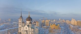
- Holy Trinity Cathedral. The largest cathedral on the peninsula, it can accommodate up to 3,000 parishioners. The temple was built taking into account all the features of the terrain and can withstand earthquakes with an amplitude of 10 points. The main shrine of the temple is the icon of St. Matrona of Moscow.
Museums and volcanariums
| Name | Focus |
| 1. Kamchatka Regional United Museum. | Opened in 1911, the very first exhibits appeared thanks to travelers exploring the local region. The museum's collection contains about 120,000 items that will introduce you to the history of the region, its indigenous population and their traditions. |
| 2. Military History Museum. | In July 1959, thanks to the initiative of Hero of the USSR Admiral G.I. Shchedrin, the largest museum of the Far East with military themes was opened. The museum will introduce everyone to the history of the development of the Kamchatka Navy. |
| 3. Art Museum. | Appeared in 1992, the main goal of the museum is to preserve the activities of artists of the Far East. The exhibitions include: decorative and applied works, artistic photographs, paintings, sculptures. |
| 4. Salmon Museum. | The museum opened in 2004. All visitors have the opportunity to learn about the characteristics of salmon fish, their appearance as a species on Earth, their habitat, the development of fishing in the Kamchatka Territory and the place this species occupied in the culture of the indigenous people. |
| 5. Museum of volcanoes in Kamchatka “Vulcanarium”. | The scientific and educational museum will tell you in detail about the volcanoes of Kamchatka. The exhibition features rock samples, photographs, video materials, as well as interactive models of the processes occurring inside the volcano. |
Lava caves
The famous lava caves of Gorely volcano are located 75 km away. from the city, in the northern part of the volcano, their age is 2,000 years. The longest cave has a length of 140 m, and the shortest is 16 m; there are currently 14 caves in total.
They appeared as a result of frequent volcanic eruptions. Lava flowed down the slopes in a rapid stream and, as the upper layer cooled, peculiar grottoes formed. The caves most visited by tourists are called “Dark” and “Grotto”.
There are lava caves in the area of the Tolbachik volcano; there are a little more than 10 caves there. The last of them were opened after the 2013 eruption. Not all caves are accessible for visiting, since in some the air temperature reaches -20–30 °C.
The highest cave is called “Kholodnaya”, the height of the vault is more than 10 m. The “Beautiful” cave got its name for the many multi-colored stalactites on the ceiling. You can get to the volcanoes by car or helicopter. The ascent will take from 3 to 6 hours and is suitable even for tourists who do not have special training.
Spring springs and geysers
There are about 150 large springs on the territory of Kamchatka, the closest to Petropavlovsk are Malkinskie and Paratunka.
Paratunka springs are located 60 km away. from Petropavlovsk - Kamchatsky, they are divided into several groups: Upper - Paratunka, Middle - Paratunka and Nizhne - Paratunka. The water in the springs contains a large amount of silicic acid. Helps in the treatment of diseases of the skin, musculoskeletal system and nervous system.
Malkinsky springs
Malkinsky springs are located near the village of Malki, 130 km. from the city, in the valley of the Klyuchevka River. In a small valley 0.5 km wide. There are thermal springs with hydrocarbonate-chloride-sulfate water, the temperature in them reaches 80 ° C. Visitors here are treated for diseases of the cardiovascular system, musculoskeletal system, nervous system and ENT organs.
You can get to the place by bus or car, and stay at a recreation center or in a tent camp.
120 km from the city, in the area of the Mutnovsky volcano, there is the Small Valley of Geysers. A fumoral field is located in a small area; it consists of natural holes in the ground through which hot steam and air pass. Near the valley are the Dachnye thermal springs and the Mutnovskaya geothermal power plant.
Small Valley of Geysers.
Despite the name, there are no real gushing geysers here; you can see them in the Kronnotsky Nature Reserve, and you can get there by helicopter.
Mountain ranges and hills
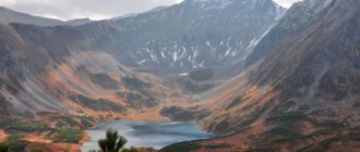
An amazing and picturesque place near the city of Petropavlovsk (about 80 km) is the Vachkazhets mountain range. It belongs to the Yuzhno-Bystrinsky ridge and is included in the “List of specially protected natural areas of regional and local significance of the Kamchatka Territory.”
Its name comes from the ancient Ietelmen word “Vachkagach”, which means “Flowing from a stone ridge”.
After the volcanic eruption, the massif was divided into three peaks: Letnyaya Poperechnaya and Vachkazhtsy. At the moment, the volcano is considered inactive. Many species of plants and animals living in this place are listed in the Red Book. In the circuses of the massif there are glacial lakes - Takhkoloch and Nikolskoye. There are many tourist routes along Vachkazhets.
On the map of Russia, Petropavlovsk-Kamchatsky is washed by Pacific waters on one side, and bordered by many hills and active volcanoes on the other. The hills are located about 30 km. from Petropavlovsk, local residents call them “Home Volcanoes”. Their peaks are visible from anywhere in the city. This group of volcanoes includes: Avachinskaya Sopka, Koryakskaya and Vilyuchinskaya.
Avachinskaya Sopka rises to 2741 m, the diameter of its crater is 400 m. It belongs to the group of active volcanoes of Kamchatka, its formation took place over 30 thousand years. The base of the volcano consists of basalt and andesite rocks, and its top is covered with an ice cap. Since 1700, the volcano has erupted 15 times, the last eruption being in January 1991.
Avachinskaya Sopka
Koryakskaya Sopka is one of the active volcanoes of Russia, its height is 3456 m, it is the highest volcano on the map of Petropavlovsk-Kamchatsky in the Avacha group. Its ancient crater is completely filled with glacier. The modern crater has a diameter of 200 m and a depth of 20–30 m.
The hill consists of basalt-andesitic rocks and has a conical shape; it belongs to the stratovolcanic group.
In the 17th century the hill was called Strelochnaya. In the area, local residents collected volcanic glass for household use. Later, in the 19th century, an ancient people settled at the foot of the volcano - the Koryaks and the hill began to be called Koryak. Scientists have found that over 7000 years the volcano erupted about 7 times. The last activity was in 2008, but lava did not reach the surface.
The Koryak hill was included in the UNESCO World Heritage List in 1996.
KORYAK SOPKA
Vilyuchinskaya Sopka is located southwest of the city on the territory of the South Kamchatka Natural Park. Its height is 2173 m, the hill is considered an extinct stratovolcano, and gas-vapor clouds often appear above its top. On the northern side, among the cones of the hill, there are lakes – Topolovoe and Zelenoe. In the eastern part there are hot springs and Vilyuchinsky waterfall.
Vilyuchinskaya Sopka is a popular place among tourists; in winter you can go snowboarding, snow scootering or skiing here.
Unique relief
Kamchatka is the most earthquake-resistant region on the planet. There are about three dozen active volcanoes in the region. Every year, some stone giants wake up and begin to erupt, while others calm down for a while. There are more than three hundred volcanoes in the region. They occupy up to 40% of the peninsula's area.
Due to volcanic formations and mountain ranges, the relief of the Kamchatka Peninsula is heterogeneous. There are no similar places on the map of Russia. From the Sea of Okhotsk, the Western Kamchatka hilly lowland stretches about 60-80 km wide.
Nature of Kamchatka photo:
The Sredinny Range is the largest mountain system in the region, which consists of highly dissected plateaus. Its length is 900 km. There is only one volcano here - Khangar, which was active more than one and a half thousand years ago. In the basin of the Bystraya and Kamchatka rivers, which flow into the Bering Sea, the Central Kamchatka Lowland is located; it stretches for 500 km.
Volcanoes and 70% of the thermal springs of the peninsula are located in the Eastern volcanic zone. It runs along the entire peninsula from north to south and is a turbulent area where eruptions constantly occur.
In 2008, the Koryakskaya Sopka released a powerful smoke plume that reached Petropavlovsk-Kamchatsky. In 2010, the Gorely volcano, which is located 80 km from the capital of the region, awoke. In 2014, the Shiveluch, Zhupanovsky and Karymsky volcanoes showed their character, and in January 2015, Avachinskaya Sopka.
In the peninsula news today:
- The Karymsky volcano threw out a three-kilometer column of ash.
- More than 10 earthquakes occurred off the coast of Kamchatka in one day.
Volcanoes are depicted on the flag and coat of arms of the Kamchatka Territory, as well as the city of Petropavlovsk-Kamchatsky. The volcanoes of the Kamchatka Peninsula are a UNESCO World Heritage Site.
There are specially protected natural areas on the peninsula: three state reserves:
- Kronotsky Reserve
- Commander Reserve
- Koryak Nature Reserve
as well as five natural parks, nature reserves, and natural monuments.
Watch the video:
Interesting facts about the city
- The main construction began in 1960 during Soviet industrialization.
- All buildings in the city are no higher than 5 floors, due to frequent earthquakes.
- The city produces about 80% of the industry of the Kamchatka Territory.
- Included in the list of cities of historical value.
Petropavlovsk-Kamchatsky is one of the most ancient cities on the map of Russia. Over the course of several decades, the city has turned into a cultural and historical center of the Far East, with developed infrastructure and industry.
Article design: Vladimir the Great
Crime
The most common crimes in Petropavlovsk-Kamchatsky are somehow related to poaching. In the 90s, the “earners” sorted things out among themselves. Since the 2000s, they have been fighting against law enforcement agencies. Unfortunately, the police in Kamchatka are very corrupt and they do not fight all poachers. Those who pay for their peace of mind do not experience any discomfort. The rest sometimes have to sweat, hiding from pursuit.
There have never been any high-profile contract killings in Petropavlovsk-Kamchatsky. Mostly only Mother Nature is stolen or robbed here, so we can summarize that the city, despite all its greyness, is quite calm.