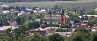
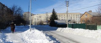
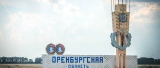
Gai, Orenburg region, is a small town in the Russian Federation, with an area of 62 square meters. km. The discovery of copper pyrite ores served as the reason for the founding of the settlement. The population of Gaya as of 2022 is 35,255. The city is located next to the Iriklinsky reservoir. The telephone code of the city of Gaya is 53362, postal code is 462630.
From origins to today
According to one version, the name comes from a birch grove that grows near a healing spring within 6 km from the village. In the Orenburg area there is an abundance of plantings that were planted by pioneers from Belarus and Ukraine. Settlers have been developing the territory here since the 18th century. The word "gai" is of Belarusian origin, meaning grove.
But a more plausible version of the name's origin is part of the history of the Civil War. One of the heroes of military operations, G.D. Gai, who participated in the suppression of the Orenburg Cossack rebels in 1937, was repressed. After his restoration, the party published many works about the hero’s life. Since then, the city received this name, and one of the main streets in Orenburg is named after Guy.
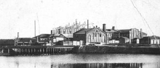
On the territory of the modern city there used to be a mining and processing enterprise , and in 1959 a village began to form here. Thanks to the hard work of the plant workers, it was possible to set records - about 5 tons of ore were mined in a year. The authorities announced the construction of the plant and mining village as an All-Union shock construction project. The number of jobs grew, schools, residential buildings, kindergartens, and public baths needed to be built.
Since 1979, the settlement has become a city of regional subordination. In 1999, the coat of arms of Guy was established. Now there is a medical school, 10 educational schools, and a department of the Bashkir Legal College. Children have the opportunity to attend sections in sports and art educational institutions.
Guy
(Orenburg region)
OKATO code:
53413
Founded:
1959
Urban settlement since:
1965
City since:
1979 City of regional subordination
Center:
Gaisky district
Telephone code (reference phone)
| 35362***** | 210-99 |
Deviation from Moscow time, hours:
2
Geographic latitude:
51°28′
Geographic longitude:
58°27′
Altitude above sea level, meters:
380 Sunrise and sunset times in the city of Gai
City symbols
Guy has its own special symbols - a coat of arms and a flag. The coat of arms depicts a hammer, and on top of it is a butt. Everything is done on a red background. Below is a silver copper smelting furnace in the form of a building combined with a chimney on the left. Below is the slogan “Remember the past, believe in the future!” The inscription, made in silver paint, is on a red ribbon around the main design. The coat of arms was issued in honor of the anniversary, when residents celebrated the 40th anniversary of the city.
The entire composition was developed by a Moscow company at the request of the city administration, and it was finally approved by the council of deputies on April 13, 1999. The drawing was submitted to the State Heraldry under the President of the Russian Federation for expert evaluation, after which it was included in the State Heraldic Register of the Russian Federation.
The flag is represented by a rectangular canvas, divided into 2 parts (white and blue). There is a green stripe on the bottom edge. In the center is a rock with a black eagle. Above the green stripe on a blue background is the rising sun. The symbolism of the drawing denotes the historical and geographical features of the area.
The black eagle is part of the Orsk coat of arms. It is a symbol of a person's ability to endure difficulties and strive forward. The sun symbolizes light and knowledge. The green stripe indicates the fertility of agricultural land. White color - perfection and wisdom, blue - sublime aspirations.
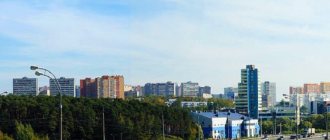
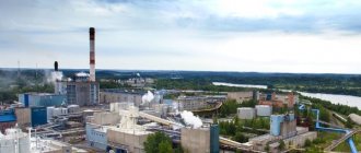
Economic condition
The main branch of the city's economy is metallurgy, but other enterprises operate here, and private business is developing. The retail network is represented by shops and retail spaces, pavilions. Main industrial enterprises:
- OJSC "Gaisky Mining and Processing Plant";
- NGO "Gaisky Non-Ferrous Metals Processing Plant";
- SEC "Gayskaya Poultry Farm";
- LLC Gaisky plant of mine rescue equipment "OZON";
- CJSC "RIFAR".
All telephone data of organizations and companies are in the directory. Since 2014, according to a government decree, Gai has been included in the number of cities where there is a risk of environmental deterioration.
Historical and cultural sites
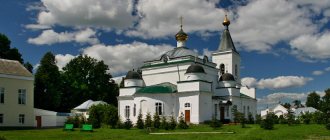
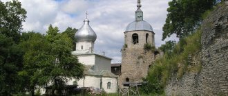
The sights of Gaya, Orenburg region, are of a religious nature and are of great importance to local residents. You can visit the Cathedral of John of Kronstadt, an Orthodox church built in 2002. It is located at: Orskaya street, 133.
Naturally, how can a city exist without the main monument? A statue dedicated to the founders of the city - the miners. According to the design of the artist N. G. Pepin, the Miner monument was erected in 1970. The following places have cultural and historical value:
- a local history museum, which contains samples of local flora and fauna;
- showroom;
- modern sports complex;
- Palace of Culture of Miners;
- cinema;
- children's creative center "Rainbow".
The Church of Peter and Paul in the city of Gai was founded in 1993. 5 years later, a bell tower and a church store were built. In 2009, a religious procession took place to the village of Kherson, where a similar structure is located.
Routes on the map of Gaya. Transport infrastructure
On the available maps of the city and detailed information posted on the website of the City Administration, you can see how easier it is to arrive.
The city has a railway station (the intersection of Voichenko Street and Orskoe Highway) on a line connecting it with Orenburg, Orsk, Novotroitsky, Mednogorsk, Novoorsk.
There are bus routes along the highway to many cities in the Orenburg region.
City trips are served by shuttle buses and taxis. The map of Gaya with houses contains information about current urban transport routes.
Features of the city
The weather in Gaya is not particularly mild and warm. The continental climate is characterized by cold and snowy winters and short, warm summers. The peak of cold weather occurs in January, with temperatures hovering around -17 0C. In July the maximum is 21 0C. From time to time, precipitation falls here (rain or snow), on average up to 300 mm per year.
The Gai sanatorium operates 6 km from the city. This is a balneo-mud resort where mineral water and natural mud of the lake are used. Also not far from the city you can undergo health treatments at a hydropathic clinic.
Using the Yandex. On the map you can easily see street names and exact house numbers. You can also see the location of the city on a map of Russia.
Statistics show a downward trend in population. Today, Gai ranks 452nd among 1,113 cities in the Russian Federation in terms of population.
Most of the real estate belongs to the city housing stock. All houses are equipped with central heating and gas. There is running water, sewerage, hot water supply. The head of the Gai urban district every year takes care of paying subsidies for housing and utilities, as well as supporting the population through social protection authorities.
History of the Gai region for 2 thousand years
In the 1st millennium BC and in the first centuries of our era, the expanses of the Volga-Ural steppes were occupied by tribes of the Sarmatians and Scythians, descendants of the tribes of the Andronovo and Srubnaya cultures, which were characterized by burial mound rituals. As a result of archaeological research, burial mounds of the Late Paleolithic were identified near the village of Ishkinino and in the vicinity of the village. Banny.
At the end of the 4th century. a powerful wave of movements of nomadic tribes arose from the Trans-Ural steppes to the west. The great migration of peoples began with the Huns, who ousted the Alans (late Sarmatians) from the steppes; in the 5th century - Bulgarians, in the 6th century. - Obry (Avars), in the middle of the 7th century. - Khazars; in the 9th century - the Pechenegs, who roamed the Caspian steppes. Nomadic pastoralists who were part of the Pecheneg union and called “Bashkort” (Bashkirs) in the 8th-9th centuries. advanced north and occupied the Belaya River basin. They gradually assimilated the local Finno-Ugric population, giving them their language and name. The Arab traveler Ibn Fadlan, who visited Volga Bulgaria in 922, mentioned in his notes the country of the Turkic people called “Bashkirs”.
The last movement of peoples from Asia to the West was the invasion of the Tatar-Mongols in the 13th century. The territory of the present Orenburg steppes and Bashkiria became part of the Golden Horde state, which existed for about 200 years. After the collapse of the Golden Horde in the middle of the 16th century, the uluses remaining in the Volga steppes began to be called Big Nogai, and their possessions extended to the right bank of the Ural River. In the first half of the 17th century, many uluses of Bolshie Nogai left their inhabited places under the onslaught of Kalmyk nomads who invaded from the east. In the 17th - 18th centuries, the Bashkir economy was semi-nomadic. The modern names of many tracts and streams in the region still preserve the memory of their Turkic origin, as do the settlements that arose here later: Karatai, Kyzymbatka, Usayka, Yanturino.
In the 18th century, in connection with the adoption of Russian citizenship by the Small Kazakh Zhuz, the tsarist government organized a special expedition to build the city of Orenburg and the construction of a fortified border line along the Yaik (Ural). Thus, in 1735 the Orenburg fortress was founded (later renamed Orskaya) and fortresses were founded in Yaik, Samara and Sakmara. On the territory of the Gai region, the Guberlinskaya fortress (1736 -1738), the Kalpatsky (1743), and Tereklinsky (1743) redoubts were founded. The newly built fortifications began to be populated by garrison and Landmilitsky regiments, then a new irregular Cossack army was created - the Orenburg, which was started by the transferred Samara, Ufa and Iset Cossacks. All these fortified settlements at first represented simple strategic points with a military way of life, but over time they gradually took on the character of settlements where the Cossacks began to engage in fishing, cattle breeding and agriculture.
On March 15, 1744, a Personal Decree was signed “On the establishment of the Orenburg province and the subordination under its authority of the Ufa province and all fortresses being built in those places.” It also included the territory of the modern Gai region.
In 1769, the famous scientist Peter Simon Pallas visited the Guberlin fortress and left a detailed description of it. Initially, only 30 families lived here, and a small garrison served as security guards. Subsequently, 113 families of Chebarkul Cossacks were transferred from near Chelyabinsk. The road from Orenburg to Orsk—the “royal road”—passed through the village. In 1837, the motorcade of the heir to the throne, Alexander Nikolaevich, accompanied by the poet V. A. Zhukovsky, passed along it.
After the abolition of serfdom in 1861, settlers from Ukraine, the Volga region and other places in Russia flocked here to free lands. New settlements began to emerge, by the names of which it was possible to determine where the settlers came from: Novonikolaevka, Novopetropavlovka, Poltavka, Novokievka, Kherson. It was in those times that such a neighborhood of people of different nationalities developed, thanks to which there was a mutual enrichment of cultures and an exchange of experience, which is typical for the entire Orenburg region. On our land, where they were mainly engaged in cattle breeding, agriculture, gardening, and livestock began to develop.
The turning point for the population was 1917. The revolution activated the energy of the masses and, unfortunately, scattered them on different sides of the barricades. The civil war swept through the region, people were lost and the economy was undermined. But people’s desire for better was much stronger than all the difficulties. In 1919, the creation of revolutionary committees and village committees began in the region. Collective farms and state farms were organized in populated areas: “Voronezhsky” (1930), “Guberlinsky”, “Tempi Sovetov”.
The industrialization of the country gave impetus to the development of industry. The territory of the district holds the record among the regions in terms of the number and variety of minerals. The chromite mine near the Khalilovo station already in 1926 received 22 percent of the all-Union chromite production. Iron mines grew near the village: Khalilruda (1929), Akkermanovsky (1931), and Aidarbak nickel mine (1938).
On December 7, 1934, on the basis of the Resolution of the All-Russian Central Executive Committee “On the division of the Gorky and Middle Volga regions and the formation of new regions,” the Orenburg region was formed, which included 52 districts. One of them was the Khalilovo district, with the district center in the village of Khalilovo. The district included about one hundred settlements included in 18 village councils (Alexandrovsky, Voronezhsky, Voskresensky, Guberlinsky, Ishkininsky, Izhberdinsky, Karatalsky, Kameykinsky, Malokhalilovsky, Narbulatovsky, Novoumansky, Novopetropavlovsky, Novocherkassky, Novokievsky, Novonikolaevsky, Orlovsky, Saverovsky, Uzembaevsky ) and one council - Khalilovsky. 36 collective farms, 3 state farms, and several industrial enterprises were formed. The construction of an industrial giant, the Orsk-Khalilovsky Metallurgical Plant, began, and later the village of Novotroitsky was transferred to the city of Orsk (01/15/1941).
Peace plans were interrupted by the war. 5,236 people were called up to the front from the Khalilovsky district. Our fellow countrymen fought bravely against the Nazi invaders. The high title of Hero of the Soviet Union was awarded to: Vasily Kharitonovich Kordyuchenko from the village of Saverovka, Nikolai Ivanovich Rudenko from the village of Novokievka. Vasily Petrovich Voichenko, a native of the village of Kameikino, became a legend of the partisan movement and a national hero of Poland. 1987 of our fellow countrymen did not return from the front. Their names are included in the Book of Memory, carved on obelisks and monuments installed in almost every locality.
It was not easy for those who worked in their native land during these years. The region received equipment from a nickel plant from Monchegorsk and a plant named after Artyom from Voroshilovgrad. During the war years, the district's collective farms handed over 1,662,000 pounds of grain and many other products to the state. Workers of the Khalilovsky district contributed 11,936 thousand rubles free of charge for the construction of tanks and aircraft. Komsomol members of the region worked heroically in agricultural work. In 1942, for the selfless work of the regional Komsomol organization, the challenge Red Banner of the Komsomol Central Committee was awarded. The village of Khalilovo and the settlements of the region received hundreds of evacuees during the war.
After the end of the war, Khalilovsky district began peaceful work. Great efforts were required to restore agriculture. There was no equipment, there was not enough draft power, but people worked tirelessly, and by 1950 the pre-war level of agricultural production was achieved.
1954 was the year of the beginning of the development of virgin and fallow lands. Boys and girls with Komsomol vouchers arrived at Khalilovskaya, Kolpakskaya, Novonikolaevskaya MTS, collective farms named after. Shevchenko, them. Kalinina and others. In total, 14.5 thousand hectares of new land have been developed in the region. The Peredovik state farm was created on virgin lands. For the development of virgin and fallow lands, the Order of Lenin was awarded to the director of the Tanalyksky state farm V.N. Frolov, the director of the Shevchenko state farm S.F. Agryutenkov, the foremen of the tractor and field crop brigades A.P. Rubanyuk (Novonikolaevskaya MTS), P.E. .Boiko (Khalilovskaya MTS). For many pioneers of the virgin lands, the Gai region became their home; they forever remained to live in the steppe region.
Based on the Decree of the Presidium of the Supreme Soviet of the RSFSR dated November 3, 1960, the district center was moved from the village of Khalilovo to the working village of Gai, and the district was renamed Gaisky.
The modern Gai district is given the status of a municipal district; according to the population census, 10 thousand 331 people live in 33 settlements of the district. It consists of 8 municipalities of rural settlements, including 2 town councils and 6 village councils:
Iriklinsky village council: Iriklinsky village, villages: Vishnevoe, Novoaktyubinsk, Terekla, Uralsk.
Khalilovsky village council: villages: Khalilovo, Novovoronezhsky, Gainulino, Lylovo, Narbulatovo, villages: Starokhalilovo, Malokhalilovo, Uzembaevo, Izhberda and the village of Voskresenka.
Guberlinsky village council: villages: Khmelevka, Cossack Guberlya, Beloshapka.
Kameikinsky village council: Kameikino village, Ishkinino village, villages: Popovka and Saverovka.
Kolpaksky village council: villages: Kolpaksky, Bannoye, Plaskovskoye, Kherson village.
Novonikolayevsky village council: villages: Novonikolayevka, Pisarevka and Novocherkasskoye.
Novopetropavlovsk village council: villages: Novopetropavlovka, Novokievka and the village of Rozhdestvenka.
Repinsky village council: Repino village.