Kotovsk
(Tambov Region)
OKATO code:
68410
Founded:
1912
Urban settlement since:
1930
City since:
1940 City of regional subordination
Telephone code (reference phone)
| 47541***** | 42-2-10 |
Deviation from Moscow time, hours:
0
Geographic latitude:
52°35′
Geographic longitude:
41°30′
Altitude above sea level, meters:
130 Sunrise and sunset times in the city of Kotovsk
Map
| Kotovsk: maps |
Kotovsk: photo from space (Google Maps) Kotovsk: photo from space (Microsoft Virtual Earth)
| Kotovsk. Nearest cities. Distances in km. on the map (in brackets along roads) + direction. Using the hyperlink in the distance , you can get the route (information courtesy of the AutoTransInfo website) | |||
| 1 | Builder | 8 () | NW |
| 2 | Pokrovo-Prigorodnoye | 12 () | NW |
| 3 | Tambov | 15 (15) | WITH |
| 4 | Novaya Lyada | 17 (29) | NE |
| 5 | Znamenka | 19 (54) | YU |
| 6 | Satinka | 26 (43) | SE |
| 7 | Rasskazovo | 27 (45) | IN |
| 8 | Bondari | 55 (76) | NE |
| 9 | Dmitrievka | 58 (70) | NW |
| 10 | Rzhaksa | 60 (90) | SE |
| 11 | Tokarevka | 69 (97) | YU |
| 12 | Inzhavino | 72 (121) | SE |
| 13 | Sosnovka | 72 (77) | WITH |
| 14 | Zavoronezhskoe | 72 (82) | NW |
| 15 | Mordovo | 74 (106) | SW |
| 16 | Michurinsk | 76 (88) | NW |
| 17 | Kirsanov | 83 (108) | IN |
| 18 | Zherdevka | 83 (97) | YU |
| 19 | Uvarovo | 84 (113) | SE |
| 20 | Petrovskoe | 84 (118) | Z |
| 21 | Dobrinka (Lipetsk region) | 84 (134) | SW |
| 22 | Pichaevo | 86 (113) | NE |
| 23 | Gavrilovka 2nd | 91 (131) | IN |
| 24 | Ertil | 96 (134) | SW |
| 25 | Staroyurevo | 97 (125) | NW |
| 26 | Morshansk | 98 (97) | WITH |
| 27 | Will clean | 99 (130) | IN |
| 28 | Ternovka (Voronezh region) | 100 (118) | YU |
| 29 | Muchkapsky | 104 (133) | SE |
| 30 | Mud | 106 (121) | Z |
a brief description of
Located in the center of the Oka-Don Plain, on the right bank of the river. Tsna, 13 km south of Tambov. Railway Tambov-II station.
Territory (sq. km): 17
Information about the city of Kotovsk on the Russian Wikipedia site
Historical sketch
It arose before the First World War of 1914-18 as a settlement for the builders of the state gunpowder factory (the decision to build it was made in 1912).
In 1918 it received the name Shock, in 1919 Red Action. The workers' settlement of Krasny Boevik from February 28, 1928. Later it became part of the Industrial District of the city of Tambov.
In 1940, the Industrial District of the city of Tambov was transformed into the city of Kotovsk, named after the civil war participant G.I. Kotovsky (1881-1925), who in May 1921 suppressed the anti-Soviet peasant uprising in the Tambov province led by A.S. Antonov.
The development of the gunpowder plant gave rise to the development of the chemical industry and chemical engineering in the Tambov region.
Municipal indicators
| Index | 2001 |
| Demography | |
| Number of births, per 1000 population | 8.5 |
| Number of deaths, per 1000 population | 18.4 |
| Natural increase (decrease), per 1000 population | -9.9 |
| Standard of living of the population and social sphere | |
| Average monthly nominal accrued wages, rub. | 1836.5 |
| Average housing area per inhabitant (at the end of the year), sq.m. | 18 |
| Number of preschool institutions, pcs. | 10 |
| Number of children in preschool institutions, thousand people | 1.2 |
| Number of daytime educational institutions (at the beginning of the school year), pcs. | 6 |
| Number of students in daytime educational institutions, thousand people | 4.3 |
| Number of doctors, people. | 101 |
| Number of nursing staff, people. | 320 |
| Number of hospital institutions, pcs. | 1 |
| Number of hospital beds, thousand units | 0.4 |
| Number of medical outpatient clinics, pcs. | 4 |
| Capacity of medical outpatient clinics, visits per shift, thousand units. | 0.9 |
| Number of registered crimes, pcs. | 404 |
| Persons who committed crimes were identified, persons. | 277 |
| Economy, industry | |
| Number of enterprises and organizations (at the end of the year), pcs. | 377 |
| Construction | |
| Volume of work performed by type of activity “Construction” (until 2004 - volume of work performed under construction contracts), million rubles. | 25.5 |
| Commissioning of residential buildings, thousand sq.m. of total area | 0.5 |
| Commissioning of residential buildings, apartments | 3 |
| Commissioning of preschool institutions, places | 0 |
| Commissioning of educational institutions, places | 0 |
| Commissioning of hospital facilities, beds | 0 |
| Commissioning of outpatient clinics, visits per shift | 0 |
| Transport | |
| Number of bus routes (in intracity traffic), pcs. | 4 |
| Number of passengers transported by buses per year (in intracity traffic), million people. | 4.1 |
| Connection | |
| Number of residential telephone sets of the city public telephone network, thousand units. | 8.9 |
| Trade and services to the population | |
| Retail trade turnover (in actual prices), million rubles. | 290.6 |
| Retail trade turnover (in actual prices), per capita, rub. | 7941 |
| Public catering turnover (in actual prices), million rubles. | 36.9 |
| Volume of paid services to the population (in actual prices), million rubles. | 107.4 |
| Volume of paid services to the population (in actual prices), per capita, rub. | 2933.4 |
| Volume of household services to the population (in actual prices), million rubles. | 13.7 |
| Volume of household services to the population (in actual prices), per capita, rub. | 375.1 |
| Investments | |
| Investments in fixed assets (in actual prices), million rubles. | 38.3 |
| Share of investments in fixed assets financed from budgetary funds in the total volume of investments, % | 3.7 |
Data sources:
- Regions of Russia. Main characteristics of the constituent entities of the Russian Federation: statistical collection. Goskomstat of Russia. - M:, 2003.
Economy
Kotovsk is an industrial satellite city of Tambov.
The main industry is chemistry: factories - plastics, paint and varnish; artificial leather factory.
Precast concrete plant, brick factory, pasta and clothing factories, etc.
Main enterprises
CHEMICAL INDUSTRY
State Enterprise "Kotovsky Kotovsky Paint and Varnish Plant"
393170, Tambov region, Kotovsk, st.
Zheleznodorozhnaya, 2 Offers:
solvents, epoxy resins, varnishes, enamels, drying oils, water-based paints, phenolic resins, primers
ELECTRONICS INDUSTRY
OJSC "Almaz"
393170, Tambov region, Kotovsk, st.
Svobody, 1 Offers:
microelectronics products, electric fan heaters for industrial and domestic use
Architecture, sights
Until the 1960s Kotovsk was considered the most comfortable and green city in the Tambov region. However, the increase in chemical production volumes has sharply worsened the environmental situation in the city.
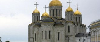
In the vicinity of Kotovsk, on the banks of the river. Tsna (between Kotovsky and Tambov) - the remains of the buildings of the Tregulyaev-Predtechensky Monastery (second half of the 17th-18th centuries).
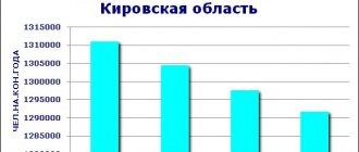
| Population by year (thousands of inhabitants) | |||||||
| 1916 | 8 | 1996 | 38.5 | 2008 | 32.5 | 2017 | 30.4 |
| 1931 | 2.8 | 1998 | 38.0 | 2010 | 32.0 | 2018 | 30.0 |
| 1959 | 25.5 | 2000 | 37.3 | 2011 | 31.9 | 2019 | 29.4 |
| 1967 | 30 | 2001 | 36.8 | 2012 | 31.6 | 2020 | 29.0 |
| 1970 | 33.3 | 2003 | 34.1 | 2013 | 31.4 | 2021 | 28.7 |
| 1979 | 37.8 | 2005 | 33.3 | 2014 | 31.2 | ||
| 1989 | 38.5 | 2006 | 33.0 | 2015 | 31.1 | ||
| 1992 | 38.6 | 2007 | 32.6 | 2016 | 30.7 | ||
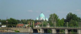
Kotovsk is the regional center of the Odessa region, a large railway station in the south of Ukraine
Kotovsky district - formed in 1923. Area of the district - 1013 square meters. km, population - 79.7 thousand people, including rural - 37.4 thousand people. The average population density is 78.6 people per 1 sq. km. The center of the district is the city of Kotovsk, a large railway junction of the Odessa-Kishinev Railway in southern Ukraine. Previously, the city had a different name - Birzula.
In 1925, the famous Soviet military leader Grigory Ivanovich Kotovsky was buried in the mausoleum in Birzula. Kotovsky's mausoleum was destroyed during the Romanian occupation of Transnistria during the Great Patriotic War. From 1928 to 1929 Birzula was the capital of the Moldavian Autonomous Soviet Socialist Republic. In 1935, Birzulu was renamed Kotovsk and in 1938 it was given the status of a city of regional subordination in the Odessa region. Since 1940, Kotovsk has been part of the Odessa region of the Ukrainian SSR. Located on the left bank of Yagorlyk, 188 km north of Odessa. The territory of the current city was formed from the village of Birzuly, the station village of the same name (merged in the first quarter of the 20th century), as well as the villages of Lunchi, Mikhailovka and Vinogradovka, assigned to the city in July 1938. The city received its new name in honor of the hero of the Civil War of 1918-1921. Grigory Ivanovich Kotovsky, after his murder in 1925. The first settlers - peasants who fled from the Right Bank of Ukraine from the oppression of the Polish gentry - appeared here in the second half of the 18th century. They founded the village of Birzulu, where there were about three dozen adobe huts and dugouts. It was first mentioned in Turkish written sources in 1779, among other settlements in the Dubossary district. The toponym Birzula, of Turkic origin, was formed by merging the words “bir” - tribute, tax, tax and “zyula” - tract, capturing the position of the first settlers, who were subject to the system of taxes and duties established in the Turkish-controlled region. The village residents were engaged in agriculture - they grew wheat, barley, oats, corn, melons, grapes, as well as livestock - they raised cattle, sheep, and pigs. After the signing of the Yassy Peace Treaty in 1791, according to which the lands between the Bug and the Dniester went to Russia, Birzula began to grow rapidly due to the influx of population from Podolsk and other provinces of the country. In 1795, there were 102 households with 412 residents (202 males and 210 females). At the beginning of the 19th century. The peasants of Birzuly fell into serfdom. A large tract of fertile lands passed to Princess Kontaladzina; The village residents had tiny plots of land at their disposal. Cruel forms of corvée labor, frequent crop failures, and recruiting undermined small peasant farms, and over time completely ruined them. Birzula began to fall into disrepair. The population was illiterate and did not receive medical care, since the only doctor in the entire district was in Dubossary and only the wealthy part of the peasants could use his services. A half-starved, miserable existence led to high mortality, especially among children. The predatory reform of 1861 did not make significant changes to the financial situation of the peasants of Birzuly. Burdened with high ransom payments and government taxes, they, as before, suffered from poverty and hunger. According to the census of 1886-1887, in the village, together with the nearby three sparsely populated farmsteads, there were 204 households, where 939 people lived (192 households with 859 residents - in the village and 12 households with 80 residents - on the farmsteads). 68 farms were landless; the rest of the peasantry had at their disposal only 176.6 dessiatines. Having a small number of draft animals (122 horses and 70 oxen), as well as primitive farming equipment (several farms still plowed with a wooden plow), the peasants of Birzuly received meager harvests and did not have the means to make the redemption payments established after the reform. By the mid-80s, more than two dozen poor people were forced to go to work, many became dependent on kulaks, and some village residents turned into artisans. An important role in the economic development of Birzula was played by the Odessa-Balta railway, built in the mid-60s of the 19th century {History of the Ukrainian SSR. vol. 1, p. 465.}. During its construction, a settlement of railway workers called Birzulovsky grew up 2 km from the village. Previously, the Lipetsk postal station was located here; in 1859 it consisted of three courtyards, where 25 people lived. In 1887, there were 474 residents in the railway village, there were 19 houses, 8 huts and 21 dugouts. Due to overcrowding, people lived in unsanitary conditions, with several families in one house. In 1867, a locomotive depot was opened in the village, which had six locomotives in operation; railway workshops, a station building and wooden platforms were built. 86 people worked at the depot. Every year the station's cargo turnover increased, the flow of goods increased, especially grain, which was transported to the Odessa port for export. According to data from 1895, in the village of Birzule there was a brick factory, four shops, a tavern, and at the station and in the village of Birzulovsky there was a steam mill, a wine cellar, a wholesale warehouse for wine and alcoholic beverages, five shops, a weather station {List of populated areas of the Kherson province and statistical information about each settlement. Kherson, 1896, p. 1083, 1084.}. Both permanent workers and day laborers engaged in loading, unloading, repair and other work were subjected to severe exploitation by employers and contractors. They were forced to work 12-15 hours a day, content with a salary that was barely enough to feed themselves. Birzula in the 80-90s was one of the major markets for hiring workers. V.I. Lenin in his work “The Development of Capitalism in Russia”, analyzing the growth of the agricultural proletariat, named Birzulu among other markets where thousands of workers gathered and where employers gathered. People from various regions of Ukraine, Russia, and Moldova came here in the hope of finding work. On Sundays, over 9 thousand people gathered here {Lenin V.I. Complete Works, vol. 3, p. 238.}. While waiting to be hired, the newcomers lived in the open air, ate as best they could, and often went hungry. In 1894, the zemstvo opened a public catering facility in Birzula. One of the newspapers of that time wrote about him: “Many hungry people crowd around the kitchen, asking for at least a little borscht or bread to satisfy their hunger. Others take one lunch for two or three" {"Southern Review" (Odessa), December 25, 1896}. But not always those who wanted to get a job were able to find one right away. Many of them had to wander for a long time along dusty roads from village to village. The large influx of labor made it possible for landowners and kulaks to dictate their terms when hiring, forcing farm laborers to work for meager pay throughout daylight hours. The plight caused the workers of Birzula to be indignant at the capitalist order and led to the idea of the need to join forces to fight for improved living and working conditions. Close communication between local workers and those arriving from the central regions of Russia contributed to the growth of their class consciousness. The “South Russian Union of Workers” and other workers’ circles that arose in Odessa in the 70s had a great influence on the increase in the political activity of the workers of Birzula {Pershina Z.V. Essays on the history of the revolutionary movement in the South of Ukraine, p. 134, 162.}. Illegal literature and proclamations were delivered to Birzulu. In November 1876, gendarmes discovered at the station a box with prohibited literature - the works of N. G. Chernyshevsky and other prohibited publications. …..
«History of cities and villages of the Ukrainian SSR”, Volume “Odessa Region”, p. 566
- Kotovsky district
63 settlements are subordinate to the city and 16 village councils, including:
- Settlements:
- Aleksandrovka, Alekseevka, Andreevka,
- Borshchi (Village), Borshchi (village), Bochmanovka,
- Vel. Burilovo, Vel. Kondratovka, Vel. Fountain, Vesternichany, Cherry,
- Gertopy, Guiderim, Glubochok, Honorata, Goryevka, Grekovo Second,
- Grekovo First,
- Dibrovka, Domnitsa,
- Efrosinovka,
- Calm, Green Kut,
- Kachurovka, Kirillovka, Klimentovo, Kosy, Kosy-Slobodka, Kuibyshevskoye, Kuyalnik,
- *Kotovsk (district center),
- Lipetskoe, Lyubomirka,
- Small Alexandrovka, Mal. Kondratovka, Mal. Petrovka, Mal. Fountain, Mardarovka, Murovnaya,
- Nestoita, Nikolaevka, Nikolaevka First, Novaya Kulna, Novoselovka,
- New world,
- Obrochnoe,
- Pavlovka, Padretsovo, Pereshory, Petrovka, Poplavka,
- Rozalevka, Romanovka,
- Sobolevka, Stanislavka, Old Kulna, Stepanovka,
- Topic,
- Fedorovka,
- Chapaevka, Chapaevka, Chubovka,
- Yasinovo
- Some of this is already history or nostalgia for the times of the Soviet Union
There are 106 party, 201 trade union and 117 Komsomol organizations in the region. The main direction of the region's economy is agricultural production. 9 collective farms and the elite seed-growing farm “Path to Communism” are assigned 65,882 hectares of agricultural land, including 57,700 hectares of arable land. There are 21 industrial enterprises. The population is served by 14 medical institutions (355 doctors and 1,189 specialists with secondary medical education). In 41 secondary schools, including 9 secondary schools, 25 eight-year schools and 7 primary schools, 5597 students study and 597 teachers work. Kotovsky City Market
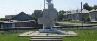
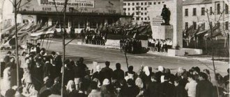
In the settlements of the district there are 49 cultural centers and clubs, 50 libraries, 2 museums on a voluntary basis, 54 stationary film installations. There are 8 monuments to V.I. Lenin, a monument to G.I. Kotovsky, 83 monuments and obelisks to soldiers-liberators and fellow villagers who died in the fight against fascism during the Great Patriotic War.
- Honored Master of Folk Art of Ukraine, Larisa Shusterman, nee Kovalchuk, master of satin stitch embroidery, was born in the city of Kotovsk.
- Vladimir Muntyan, Honored Master of Sports in football, midfielder of Dynamo Kyiv and the USSR national team, was born.
History of Cities and Villages, 2009-2010.
Related pages:
- The last line of defense of Odessa
- The situation is difficult before the closure of the tuberculosis department of the Moscow hospital near Kotovsky
- Whose body rests in the Kotovsk Mausoleum?
- Odessa had its own passenger flotilla
- Map of Kotovsky district
- Chabanka or Chernomorskoe village (Division)
- Belyaevka is the regional center of the Odessa region on the Dniester River
Recent pages from the section:
- There was a time when Dynamo Kyiv played football with the local team in Razdelnaya
- Razdelnaya is the regional center of the Odessa region, a large railway station in the south of Ukraine
- Frunzovka is the regional center of Odessa region
Previous pages from the section:
- Shiryaevsky district
- Frunzovsky district
- Tatarbunary district
Next page >>