Airport
Samara Kurumoch is the largest international airport in the entire Volga region. Geographically, Samara's air harbor is located outside the city - 35 kilometers from it in a northern direction near the village of Bereza. The airport serves not only Samara, but also residents of Togliatti (the city is located 45 km from Kurumoch), settlements of the Ulyanovsk region and even the Kazakh city of Uralsk.
Kurumoch passenger traffic in 2022 amounted to about 3 million people, which is the 13th indicator in the country. The airport serves a number of Russian and foreign airlines (Turkey, Czech Republic, Greece, Finland, UAE, Spain, Tajikistan, Uzbekistan and others). There are flights from Kurumoch to more than 108 destinations: about 50 regular flights to Russian regions, 20 flights to near and far abroad, and the rest to flights around the Volga region.
Popular destinations in Russia are Moscow, Yekaterinburg, Sochi, St. Petersburg, Surgut and other cities; international flights include Antalya, Dalaman, Larnaca, Barcelona, Dubai, Djerba, CIS countries and many others.
Due to the remoteness of the airport from Samara, it can be reached by bus from the central bus station (flights to Togliatti with a stop at Kurumoch). The air harbor also has a railway connection - Aviaexpress trains departing from the Samara central station.
Natural attractions
Zhigulevsky Nature Reserve and the Stone Bowl tract
Address: s. Bakhilova Polyana, st. Zhigulevskaya 1 Phone: 8 (84862) 3-78-38 Website: https://zhreserve.ru/ Opening hours: 08:00 - 17:00 Mon-Fri, lunch - 12:00 - 13:00, Sat-Sun — day off Cost: 50 rubles
The Zhigulevsky Nature Reserve is not part of Samarskaya Luka, but is located on its territory.
There are some plants here that grow only in Zhiguli: milkweed Zhiguli, kachim Zhiguli, kachim Yuzepchuk and sunflower Zhiguli.
In the reserve you can visit the Stone Bowl tract. The shape of the Shiryaevsky ravine resembles a bowl - hence the name.
It houses the holy spring of St. Nicholas the Wonderworker. It is believed that it heals diseases. Theoretically, there shouldn’t be a spring here - the local rocks are made of limestone, which absorbs water.
According to legend, there used to be a church in Shiryaevo in honor of St. Nicholas the Wonderworker, in which a priest and a sexton served. When the Tatar Horde attacked, the monks hid a precious cup from the church here. But soon they were caught and asked where the vessel was hidden. When the Tatar Khan found the cup, it flew out of his hands and rose into the sky. Since then, a source has appeared in this place.
Observation deck "Helicopter"
Address: Administrative, st. Vetvistaya, 1 Website: https://www.vertoletka63.ru/
Observation deck in the vicinity of Samara. It is located on a hill, and from here there is a view of the Volga, the Samara Luka and the Zhiguli Mountains.
In the past, the helicopter of the chief designer of SNTK named after him landed here. Kuznetsov, where the name came from.
Samarskaya Luka National Park
Coordinates: 53.341966, 49.366659 Telephone: 8 (84862) 2–14–95 Website: https://www.npsamluka.ru/ Opening hours: 08:00 - 17:00 Mon-Fri, lunch - 12:00 - 13: 00, Sat-Sun - day off Cost: 50 rubles How to get there: by public transport - minibus No. 168 from Zhigulevsk by car - along the M5, then turn towards the village of Zhiguli
The territory of the national park is 134 thousand hectares. It houses hundreds of species of plants and animals, some of them are listed in the Red Book: golden eagle, Apollo, South Russian tarantula, short-tailed snake eagle and marsh napkin.
Samarskaya Luka has many natural attractions:
- Valiant Kurgan,
- Maiden Mountain,
- Mount Camel,
- Hanging stone.
Tsarev Kurgan
Coordinates: 53.423337, 50.122675 Volzhsky
Many pilgrims climb to Tsarev Kurgan. From here you can see the Zhiguli Mountains and the Sok River.
There are many versions of the origin of the name, one of them is that Peter I was here during the Azov campaign. He also put a cross on the top of the mountain. Another legend says that the great commander Tamerlane feasted at the foot of the mound after his victory over Tokhtamysh in 1391. Another one is that the Tatar prince Mamaon is buried here.
Sites of Iron Age people with household items were found in the mountain. Stone was taken from Tsarev Kurgan for the construction of a railway bridge across the Volga.
Cave of the Greve Brothers
Coordinates: 53.325703, 50.195064 How to get there: by public transport - buses No. 50, No. 78, No. 79 and by minibus No. 113, No. 389, No. 392, No. 406, No. 447. Stop "Sorokin Khutora" by car - take the Volzhskoe highway and turn off in front of the village of Upravlencheskiy. Distance from Samara - 20 km
This is the longest cave in the Samara region. Sites of ancient people from the Bronze Age have been discovered here.
The cave was discovered by accident - pioneers stumbled upon it in 1964. But it got its name in honor of the real discoverers - the sons of the German pharmacist Greve, who left a large inscription “1904”.
The cave contains a complex labyrinth of passages, galleries and halls.
Blue Lake
Coordinates: 53.912469, 51.488080 How to get there: by public transport - intercity buses to the villages of Leninogorskoye, Klyavlinoe, Isakly, Kamyshly. Get off at the turn in Staroe Yakushina and walk 9 km by car - along the M-5 highway, turn towards the village of Staroe Yakushina, drive to it, then another 1.5 km to the lake. Distance from Samara - 120 km
Hydrogen sulfide enters the water from the depths of the earth - this is why the lake is turquoise in color and no one lives in it.
The water temperature is always 8°C - it does not freeze even in winter.
The lake has a funnel-shaped bottom and its depth is 50 meters. Therefore, people called him “bottomless.”
There is a legend that one Mongol khan, in order to measure the depth of the lake, forced prisoners to go down to the bottom. But none of them reached him.
Mount Svetelka
Coordinates: 53.373097, 49.097316 How to get there: by public transport - by intercity bus No. 568 to the village of Usolye by car - go to Moskovskoe highway, turn after Novosemeykino onto the M-5 highway to Usinsky, take the road P-227 and through the village of Muranka to Volzhsky Utes. Distance from Samara 225 km
They say that the mountain stands on a fault in geological plates, which makes it a “place of power.” Its white limestone peak is visible even at dusk. From here you can explore the Shigonsky district.
Previously, the mountain was called Karauln Hill, because there was a guard post of the Golden Horde here.
Racheisky Bor
Coordinates: 53.377590, 47.983632 How to get there: by car - along the M-5 highway to Staraya Racheika. Distance from Samara - 210 km
Racheisky Bor is a valuable natural monument of the Volga region with cranberry bogs and mossy pine forests. This is the only taiga forest in the southeast of the European part of the country.
Rare animals live here:
- burial ground;
- landrail;
- wryneck;
- fluff;
- peregrine falcon;
- wood lark.
Train Station
The Samara Railway Station "Samara" (Komsomolskaya Square, 1) is the largest in terms of the height of the main building (101 meters with a spire) not only in Russia, but also in Europe. This is one of the city's attractions. The station building has an observation deck on the 18th floor (95 meters), which is popular both among residents and newly arrived guests. On the second floor there is a museum of the Kuibyshev Railway, where models of steam locomotives and historical buildings, various equipment of railway workers and much more are presented.
Trains depart from the Samara railway station to many Russian cities, among the popular ones are Moscow, St. Petersburg, Penza, Novokuznetsk, Kislovodsk, Orsk, Nizhnevartovsk, Astrakhan, Adler, Ufa, Makhachkala, Tyumen, Novorossiysk, Chelyabinsk and many others . Popular international destinations are mainly carried out in the CIS countries. Regular trains run from here throughout the Samara region and neighboring regions.
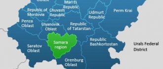
Cities and villages
Samara
Regional. The name comes from the river at the mouth of which it was built.
Guide to Samara
In 1935–1991 the city was called Kuibyshev - in honor of the statesman V.V. Kuibyshev. He actively contributed to the Bolsheviks coming to power in Samara during the October Revolution. During World War II, Kuibyshev was a reserve capital in case Moscow was captured.
After the World Cup in 2022, the city flourished and became cleaner.
Attractions:
- Samara embankment, 5 km long, begins in the historical part of the city. Here you can find: the sculptures “Barge Haulers on the Volga” and Sukhov from the film “White Sun of the Desert”, a monument to Prince Grigory Zasekin, a musical fountain, and a chapel named after St. Alexis.
- Kuibyshev Square is the largest square in Europe, on which there is a monument to Kuibyshev and the Samara Academic Opera and Ballet Theater.
- Stalin's bunker is a reserve shelter with steel doors at a depth of 37 meters for the government and the Commander-in-Chief himself during the Great Patriotic War.
- Samara Space Museum, where the Soyuz rocket stands in front of the facade. The exhibition includes satellites, prototype rockets and aircraft.
- Zhigulevsky brewery, built in 1881 by the Austrian Von Vacano. Here you can look at the industrial architecture of the 19th century and drink freshly brewed beer.
Tolyatti
Tolyatti is called the automobile capital because the famous AvtoVAZ is located here. With the advent of the plant, a lot has changed in the city: an area with wide avenues, green streets and constructivist architecture has appeared. The name also changed - before that it was called Stavropol.
Attractions:
- The local history museum tells about the history of the city: about old Stavropol, how it was flooded during the construction of a hydroelectric power station and how houses were moved to a new place, about the life of Volga peasants and archaeological artifacts found in the local soil.
- The AvtoVAZ Museum, where all production and experimental models created on the plant’s conveyors are located.
- The Sakharov Technical Museum is a field with an area of 38 hectares, dotted with various equipment: cars, helicopters, planes, armored personnel carriers. Here is the submarine B-307.
- Monument to V.V. Tatishchev, founder of Stavropol. The city was founded by him in 1737 for protection from nomads.
All the most important things you can’t miss in Tolyatti
Sizran
The city appeared at the end of the 16th century as an outpost for caravans. And, despite the big fire of 1906, Syzran has preserved many architectural monuments.
The most important thing to see in Syzran.
Attractions:
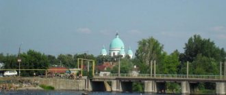
- The Syzran Kremlin is the only surviving Kremlin in the Samara region, consisting of the stone Spasskaya Tower. It was the entrance to the fortress, but later became a church.
- The Kazan Cathedral, which survived the fire of 1906, thanks to the church watchman.
- In the mansion where the exhibition hall of the Syzran Museum of Local Lore is located, lived the merchant Martinian Vasilyevich Chernukhin, who contributed to the speedy restoration of Syzran after the fire.
Zhigulevsk
A small town in the middle of the Zhiguli Mountains, which is where its name comes from. Zhigulevsk arose on the site of two villages - Otvazhnoe and Morkvashi.
The city began to be built by prisoners at the same time as the Zhigulevskaya hydroelectric power station - in the early 1950s.
Now Zhigulevsk is a city of power engineers, builders and oil workers.
It is closest to the natural monuments: Shiryaevsky adits, Samarskaya Luka and Stone Bowl.
Attractions:
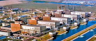
- The Zhigulevskaya hydroelectric power station, built by prisoners in 7 years, is 52 meters high and 2.8 kilometers long.
- You can climb the Zhiguli Mountains: Mutova Gora, Shishka or Otvazhnaya - and from their peaks you can get a good look at the Samara Luka and the Volga.
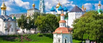
- House-museum of I. E. Repin, a famous artist, in the village of Shiryaevo. In the Volga region he painted the painting “Barge Haulers on the Volga”.
Novokuibyshevsk
Novokuibyshevsk is a key city in the fuel and petrochemical industry of the Samara region.
On the site of the modern city was one of the estates of the Orlov counts, to whom Catherine II gave the Volga lands for their help in ascending the throne. During the civil war, battles between the Bolsheviks and the Czechoslovak Corps took place in this territory.
In 1946, construction of the largest oil refinery at that time began here. Novokuibyshevsk was originally an oil workers' village, but its location turned out to be so favorable that in 1952 it was transformed into a city.
Attractions:
- House of Valery Grushin. He lived here from 1957 until his death in '67.
- The Good Angel of Peace monument (similar ones are located in Moscow, Sochi, Pyongyang and other cities) with the carved inscription: “Keep and develop the traditions of the great philanthropists of Russia, philanthropists and virtues of the past and present.”
- Museum of the History of the City of Novokuybyshevsk, numbering 18 thousand exhibits.
Chapaevsk
The city is named after the famous commander V.I. Chapaev. At the beginning of the 20th century, one of the main explosives factories, Sergievsky, was built here. And before World War II, chemical weapons were produced there under an agreement with Germany.
Attractions:
- Monument to V.I. Chapaev.
- Singing fountain in front of the Chapaev monument. In the evenings it is accompanied by illumination and music.
- A local history museum containing exhibits of the revolutions of 1917, the Great Patriotic War and the history of chemical plants.
Otradny
Otradny is a city of oil and gas workers. It arose from a small village of the same name in the mid-twentieth century, when a large oil field, Mukhanovskoye, was discovered.
Attractions:
- monument to an oil worker;
- monument to the discoverers of Mukhanovskaya oil;
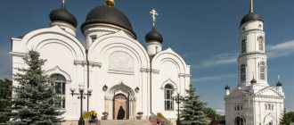
- a temple in honor of the great martyr and healer Panteleimon, crowned with 7 domes at the same time.
River Station
The Samara River Station is located on Maxim Gorky Street, 82. From here there are regular (during the navigation season) flights to settlements adjacent to the Volga, as well as tourist and entertainment cruises. Every day, ships sail from the river station to the villages of Proran, Rozhdestveno, Zolnoye, Vinnovka, Gavrilova Polyana, Osipenko and others. In winter, navigation is carried out only in the direction - Samara-Proran-Rozhdestveno (on hovercraft).
In the recent past, high-speed flights to Togliatti began to operate from the Samara river station. Hydrofoil motor ships of the Voskhod type are used to transport passengers.
Parks, entertainment and more
Museum "Motorworld of Vyacheslav Sheyanov"
Address: Volzhsky district, Petra Dubrava village, st. Klimova, 2B Telephone: Website: https://motos-of-war.ru/ Opening hours: 09:00 – 19:00 Mon-Sun Cost: 500 rubles, 300 rubles - preferential How to get there: by public transport - from Samara by buses No. 123 and No. 480 to the Petra Dubrava stop by car - exit onto Moskovskoye Shosse, turn onto Rakitovskoye Shosse, pass Zubchaninovka, exit onto highway 36K-851, turn off in front of the village of Stroykeramika and get to Petra Dubrava
The museum complex has collected a unique collection of the Golden Age of motorcycle construction, which occurred in the 1930–1940s.
There are 1,800 types of motorcycles from 14 countries, including: the best models of BMW and Harley Davidson, the first mass-produced Soviet motorcycle L-300 and tricycles - three-wheeled, tracked combat vehicles.
At Sheyanov’s Motorcycle World, motorcycles are restored so that they are as good as new.
Here you can not only learn more about motorcycles, but also ride them.
Garibaldi Castle
Address: Khryashchevka village, Rechnoy lane, 8 Phone: Website: https://garibaldicastle.com Opening hours: 07:00 - 21:00 Mon-Sun Cost: free How to get there: by public transport - from Tolyatti - minibus No. 320 from the Park House shopping center stop to the Khrushchevka village stop
Dominating the otherwise ordinary village is a neo-Gothic style castle that incorporates architecture from the Middle Ages, Renaissance and Victorian eras. It began to be built in 2006.
The interior of the castle is still being restored, so you can only get inside by appointment for a photo shoot.
Grushinsky Festival
Coordinates: 53.472444, 49.908555 Phone: 8 (846)-332-66-90 Website: https://grushinka.ru/ Cost: free How to get there: by public train to the Valery Grushin platform by car - https://grushinka .ru/2015/06/opisanie-proezda-do-grushinskogo-festivalya Distance from Samara - 50 km
A well-known festival of art songs, which has been held since 1968 - a year after the death of Valery Grushin himself.
He was a student at the Kuibyshev Aviation Institute, composed songs and played the guitar. Grushin died saving drowning people.
Many performers perform at the festival every year, including: Oleg Mityaev, Galina Khomchik, Vadim and Valery Mishchuki, Konstantin Tarasov. The chairman of the jury is Alexander Gorodnitsky.
Center for Historical Modeling "Ancient World"
Coordinates: 52.898153, 49.987975 Phone: Website: www.drevnymir.ru Opening hours: 10:00 - 17:00 Sat-Sun, Mon-Fri - days off How to get there: by public - by bus No. 631 "Samara-Pestravka" to village of Kamenny Brod by car - https://drevnymir.ru/events/priglashaem-posetiteley-v-drevniy-mir/ Distance from Samara - 47 km
- both a museum and a tourist site. Here you can immerse yourself in the old days:
- shoot a bow;
- ride horses;
- visit a real forge and pottery;
- see reconstruction of the Bronze and Stone Ages.
There are also master classes in pottery, making glass beads, cube printing, and quests in which “tribes” compete with each other.
Road transport
Samara is one of the main and largest transport hubs in Russia. In the city or in close proximity to it, the highways of Central and Western Europe, Siberian and Central Asian highways converge/pass:
- M5 "Ural" is a federal highway connecting Samara with Moscow, Rezan and Penza in the west, Ufa and Chelyabinsk in the east. The road is part of the European route E30 (Irish Cork - Omsk) and the Asian route AN6 (Belarus - South Korea).
- A300 (formerly M32) is a federal highway through Bolshaya Chernigovka to Kazakhstan and further inland. Part of the European route E121 through the whole of Kazakhstan (Atyrau, Uralsk, Beineu) to Turkmenistan (Turkmenbashi) and at the same time - the Asian route AN6.
Regional roads:
- P225 - highway to Buguruslan.
- P226 - road to Pugachev, Engels and Volgograd.
- P178 is a highway connecting Samara with Saransk, Ulyanovsk and Dimitrovgrad.
The Samara Bypass Road is also classified as a regional highway.
Historical places
Bogatyrskaya Sloboda
Coordinates: 53.338349, 49.246638 Phone: Website: https://b-sloboda.ru/ Opening hours: 10:00 - 18:00 Mon-Sun Cost: 200 rubles for adults, 150 rubles for children, under 6 years old - free How to get there: by public - by boat from the river station of the Komsomolsky district of Tolyatti by car - https://b-sloboda.ru/kontakt.html Distance from Samara - 115 km
Bogatyrskaya Sloboda is an architectural complex created by Tolyatti artist Viktor Petrov. On its territory there are wooden huts, towers and idols.
Here you can dress in chain mail, fight with swords and throw axes. But the most important thing is to ride on boats along the Usa.
Adits in Shiryaevo
Coordinates: 53.419512, 50.005632 Opening hours: around the clock Cost: 50 rubles, children under 7 - free How to get there: by public transport - by intercity bus to the village of Shiryaevo by car - get to the village of Shiryaevo. Distance from Samara — 145 km
The best limestone in the province was mined in these adits - most of the pavements in the region were built from it. The adits were made at the beginning of the 20th century.
They have a complex and confusing system of tunnels, in which it is easy to get lost. Therefore, tourists are only allowed into some of them.
Wooden windmill in the village of Barinovka
Coordinates: 52.915610, 50.820342 Opening hours: around the clock Cost: free How to get there: by public transport - by intercity bus to the village of Barinovka by car - take the P226 highway, then turn onto the P224 highway and get to the Barinovka village. Distance from Samara - 70 km
The last surviving mill in the Samara region, built in 1848. The millstones of this mill were brought partly from the Urals, partly from France.
It served until the 1960s - it was even connected to an electric motor. In the 80s, the mill was officially recognized as a monument of ancient architecture.
Samara
(Samara Region)
OKATO code:
36401
Founded:
1586
City since:
1586 City of regional subordination
Center:
Samara region
Center:
Volzhsky district
Urban areas, population as of 01/1/2021
| Railway | 88.4 | Kuibyshevsky | 89.3 | Industrial | 269.7 |
| Kirovsky | 222.5 | Leninist | 60.4 | Samara | 30.0 |
| Krasnoglinsky | 100.3 | October | 117.8 | Soviet | 166.5 |
| The city was formerly called: | ||
| Samara | 1935 | |
| Kuibyshev | 1935 | 1990 |
| Telephone code (reference phone) | |
| 846******* | — |
Deviation from Moscow time, hours:
1
Geographical latitude:
53°11′
Geographical longitude:
50°07′
Altitude above sea level, meters:
100 Sunrise and sunset times of the Sun and Moon in the city of Samara