Sanatoriums
The city of Pyatigorsk is famous for its sanatoriums, which are focused on treating patients with diseases of the musculoskeletal system and nervous system, digestion, skin, and gynecological diseases. There are more than 40 mineral water sources in Pyatigorsk. Nearby is Lake Tambukan, where sulfide silt mud is mined. At the foot of Mount Mashuk there is a unique radon mineral water source used to treat diseases of the musculoskeletal system. Of all the resorts of the Caucasian mineral waters, Pyatigorsk has the most diverse healing resources. There are about 25 sanatoriums here. All of them are multidisciplinary modern health resorts.
Churches and monasteries of Pyatigorsk
The main places of worship and Orthodox attractions.
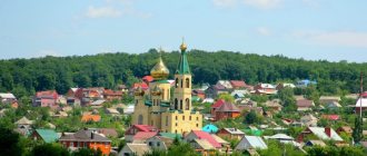
Spassky Cathedral
The main temple of the city, the construction of which began in 1845 and was completed in 1867. The cathedral stood until 1936, when it was blown up by the Bolsheviks. The restoration of the temple began in the 1990s, and it was consecrated in 2013. The cathedral was given its original appearance in the Russian-Byzantine style. It has a strict cross shape, and the facade of snow-white walls is devoid of bright decorations. The inside of the cathedral is decorated with frescoes and an iconostasis in the Fryazhsky style.
Assumption of the Second Athos Monastery
Located near Mount Beshtau. The monastery was founded by monks from Mount Athos in 1904 on the site of a Byzantine temple from the times of ancient Alania. After the monastery was closed in 1927, the buildings of the monastery gradually turned into ruins. The restoration of the monastery began in the 1990s. The modern appearance of the monastery is very different from the original one. The fraternal building is interestingly designed - it has a cylindrical shape.
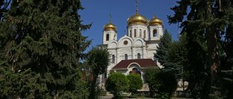
Church of Lazarus the Four Days
An active temple located next to the necropolis. Built in 1902 on the site of a dismantled church built in 1856. The temple was built in the style of Old Russian classicism in the shape of a cross. The brick walls are decorated with figured masonry. They have narrow windows. Many people note the beautiful interior decoration. The shrine of the church is the relics of St. Lazarus the Four-Days. Divine services were held in the Lazarevskaya Church even under Soviet rule.
What to see
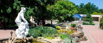
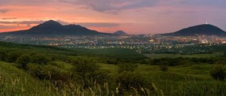
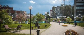
The most important wealth of Pyatigorsk is its natural resources. Therefore, among the attractions of the city of Pyatigorsk one cannot fail to mention beautiful parks with health paths. By cable car you can reach the top of Mount Mashuk, from where you can enjoy an unforgettable view of the Main Caucasus Range and the Beshtau, Zmeyka and other mountains. On the slope of Mount Mashuk there is Proval - an underground cave, a stone funnel, at the bottom of which there is a lake with healing mineral water. One of the attractions is the Aeolian Harp gazebo, named after the ancient Greek god Aeolus, lord of the winds. Below is Lermontov's grotto. We see the Mashuk spur, where the grotto is located, in a painting painted by M.Yu. Lermontov "View of Pyatigorsk".
Next to the Lermontov Baths, in the Tsvetnik park, there is Diana’s Grotto, formerly called the Elborus Grotto. On Mount Goryachaya, for the 100th anniversary of the Pyatigorsk resort in 1903, a sculpture of an eagle at the moment of a fight with a snake was installed. According to one legend, a snake bit a bird and the eagle died. But after drinking healing water, the bird managed to survive. This monument is the emblem of the Caucasian Mineral Waters. Vacationers can explore the site of M.Yu.’s duel. Lermontov and the place of the poet’s original burial. The Lermontov House museum presents an exhibition about the last days of the poet’s life and paintings on the themes of his works.
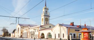
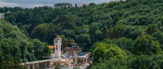
Pyatigorsky Boulevard, built in 1827–1828, is famous for its linden alleys. The continuation of Kirov Avenue to Proval is the beautiful and austere Provalsky Boulevard (now Gagarin Boulevard). The buildings of the Pushkin and Pirogov baths are interesting for their architecture. Back in the mid-19th century, a white-stone building of the Elizabeth Gallery appeared in the upper part of the gorge between Mount Goryachaya and the Mikhailovsky spur of Mashuk. Now this is the Academic Gallery, where the pump rooms of mineral springs are located. The site offers an amazing panorama of Pyatigorsk and the surrounding mountains.
Podkumok River
The Podkumok River is the most important waterway of the cities and resorts of the Caucasian Mineral Waters. In its basin there is the largest reservoir Eshkakon, which feeds Kislovodsk and Essentuki, a number of greenhouse agricultural complexes - “Valley of the Sun”, “Spring”, “Nezhinsky”, Meristem crops, etc., and also the energy of Podkumka once operated the first industrial hydroelectric power station in Russian Empire in 1903.
Podkumok originates in the mountains of Karachay-Cherkessia at an altitude of about 2000 meters on the slopes of the Kum-Bashi mountain range in the spurs of the Rocky Range. In the same ridge, but a little to the north, another equally famous river, Kuma, originates. Both rivers carry their waters to the northeast, feeding the Caspian Sea. It is curious that the Kum-Bashi mountain range is the watershed of the Azov-Black Sea and Caspian basins.
At first, Podkumok hides in a deep and narrow rocky canyon, like a typical mountain river - fast and stormy, capable of increasing several times and demolishing all obstacles in its path, but having got out of the tangle of gorges into the hilly expanses of the Foothills, it is replenished with numerous tributaries, gradually expands and moderates its mountain character. In the area of the city of Georgievsk, Podkumok meets Kuma. Having united with their sister Kuma, they together carry their waters to father Caspian.
The hydronym “Podkumok” apparently appeared as a result of a modification of the phrase “under Kuma”, indicating the secondary importance of the river. Kuma, translated from Turkic, means “sandy” - the dominant river, the third longest in the North Caucasus. Among the Karachay mountaineers there is another name for Podkumka - “Gitche-Kum”, that is, “Small Sandy”. Whatever the name, the meaning is the same: the Podkumok River is a tributary of the Kuma River.
The main source is spring underground water. There are no glaciers in the Podkumka basin; its nutrition consists of spring waters and precipitation. Podkumok is also fed by 143 tributaries, while having a length of only 147.5 kilometers. The largest tributaries are Korsunka, Eshkakon, Alikonovka, Berezovka, Essentuchek, Bugunta, Yutsa and other little-known streams.
Since ancient times, the Podkumka Valley has played a vital role in the history of the region, since caravans of the Great Silk Road passed along it already from the 6th century, and later nomadic villages of Kabardins, Abazas, and Karachais settled. And during the period of the conquest of the North Caucasus by Russia, the so-called “Dry Line” of the Caucasian defensive line passed through Podkumk. The valley was of strategic importance during the foundation of the first Russian fortresses of the Azov-Mozdok fortification line. It was on the left bank of the Podkumka that the Konstantigorsk fortress (future Pyatigorsk) was founded in 1780, and in 1798 soldiers from this fortress established a Cossack defensive post at the confluence of the Bugunta and Podkumka rivers (future Essentuki resort), and even Kislovodsk, which arose 4 versts away from Podkumka has grown over its more than two-century history, and residential, agricultural, and industrial buildings appeared on the banks of the river. So Podkumok, like a silver thread, strings pearls in the form of resort towns, villages and villages.
The beauty of Podkumka was noticed by many travelers and classics of Russian literature. A.S. Pushkin, on the pages of “Travel to Arzrum,” recalled that he was sitting on the bank of the river with his friend Nikolai Raevsky, listening to the melody of the waters. In the “notes” of M.I. Glinka we find a description of Pyatigorye, where the composer could not help but note that “Podkumok twisted like a ribbon across the plain.” In the 19th century, visitors to the waters first saw Podkumok already behind the St. George Fortress, then admired it on the way to Hot Waters, and then when they moved to Kislye Vody. And already beyond Essentuki began the same valley that many course-students spoke about with caution, believing that “a Circassian could attack from behind every bush.” Therefore, this section of the route along Podkumk to Kislye Vody was always accompanied by a convoy consisting of 20-30 Cossacks and a cannon with a lit fuse.
Railway bridge over the river
And today, the most important transport arteries of the regions of the North Caucasus run through the Podkumka valley. For example, the highway that connects the airport in Min-Vody and Kislovodsk, as well as a section of the road leading to the Black Sea coast. Along these roads, through the Kum-Bashi pass, you can get to the sources of the Kuban, Teberda, Dombay, Arkhyz, Adygea, and the mountains of the Krasnodar Territory.
The Podkumka Valley is rich in historical and archaeological antiquities, natural and geological monuments. Near the village of Pervomaisky (land of the Malokarachaevsky district of Karachay-Cherkessia) there is a cave “Hadzhi-Daut”, named after a local robber who took refuge in it to escape persecution. The main feature of the cave is sulfur dioxide, which, released from the depths, poisons the air, so being in it is life-threatening.
In the village of Pervomaisky itself, in the local Muslim cemetery, the son of the famous Imam Shamil, the military leader of the army of the highlanders during the Caucasian War (1816-1864), is buried. His middle son, Muhammad Shafi, cast his lot with Russia, unlike his brothers, and made a brilliant military career. In the last years of his life he was often ill, and was often treated in Kislovodsk. During his visit in 1906, he died of a heart attack and was buried in the nearby Muslim cemetery in the upper reaches of Podkumka in Tambievsky village (now Pervomaiskoye).
Another famous attraction is the “Rome Mountain”, or “Bergusant Fortress”. Table Mountain, 1094 meters high, was a natural defensive fortress in the first centuries of our era. Later, the main citadel of the medieval city of Caucasian Alania was located on the mountain. The Great Silk merchant caravans heading to the Black Sea stopped in the city of Bergusant, where they spent the night, acquired guides through the Caucasian passes, and sometimes took refuge from bandit raids.
Thanks to the finds, historians and archaeologists found out that there were close economic ties between the local population and traders. Since many artifacts were of foreign origin: Chinese silk, Byzantine coins, Persian jewelry, Central Asian jewelry and more. By the 10th century AD, the city had become the largest Christian center; the remains of ancient temples and church paraphernalia were found.
Later, this mountain was also used as a defensive point during the period of the Russian-Turkish troops, and today it is a monument of archeology and history.
Valley of the Podkumok River
The Podkumka Valley has a mild sunny climate, which allows for gardening and gardening. Already in the last century, the first greenhouse farms appeared: Nezhinsky JSC, Meristem Cultures, in 1935 a breeding farm was opened, and the Malokarachaevsky stud farm No. 168.
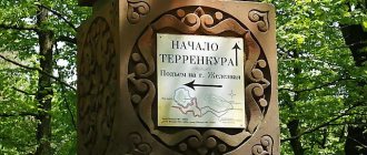
Ways to the top
Hiking on Mashuk is a pleasure, considering everything you read about in this article today. There are a great many paths, trails, and serpentines here.
The most popular mountain trail starts from the Resort Exhibition on Gagarin Boulevard. The road is three kilometers long, winding, and if you walk along it, you can reach the top in 45 minutes.
The southern slope of the mountain is difficult to climb, so tourists make their way mainly along the northern one, through the famous Perkala Arboretum.
There is also a ten-kilometer ring road. True, you can drive on it very carefully, because it is also intended for therapeutic walking. Dosed physical activity is determined by the attending physician of the sanatorium.
But the easiest and fastest way to climb Mashuk was carried out in 1971. This is a 964-meter-long cable car of the same name. Two glazed carriages with a total capacity of 40 people operate simultaneously. Thanks to it, you can be at the top within three minutes after landing.
Boarding takes place at the station near the radon baths; you can get here by bus or taxi. The cable car operates every day from 10:00 to 18:00. There is a charge for travel.
One way or another, having climbed the gentle peak of Mashuk, you can not only relax here, but also have a snack at the Eagle cafe. After going down the slope a little, you will find yourself in a wonderful clearing with gnomes, where the Gnomodom cafeteria is located.
You can also organize a wedding banquet in these cafes. Such a celebration will undoubtedly be remembered for a long time.
Flora and fauna
The nature here is magnificent! The Mashuksky forest park, encircling the foot of the mountain and connecting with the Beshtaugorsky forest park, is a green oak grove, the main types of trees in which are ash and hornbeam. Many of them are impossible to see or hug!
The vegetation on the slopes is varied: sometimes it is a meadow-like steppe, sometimes it is a subalpine meadow. And valuable. After all, more than 80 species are rare crops, and almost a third - 25 plants (for example, Mashuk's hawkweed, angustifolia snowdrop, Pyatigorsk hawkweed, rocky euphorbia) - are standards. They were discovered and described for the first time here.
29 species of Mashuk plants are listed in the Red Books of Russia and Stavropol. But on the northern slope the area is 0.42 square meters. km is allocated to the Perkalsky dendrological nursery, a little more than a third of which is given to the ecological-botanical station of the BIN RAS.
The nursery presents crops growing in the Caucasus and brought from different countries and continents. Think about it: more than 800 varieties of trees and shrubs! There are about 700 herbaceous plants, and almost 100 of them are medicinal! So, if you see magnolias and ginkgo biloba in bloom, don’t be surprised!
But even this wealth cannot be compared with what was here just over a century ago. Bird voices and animal cries filled the space. Now, when the foot of Mount Mashuk has been built up, and civilization does not stop trying to develop these promising territories, birds and reptiles are declining.
There are no badgers or the unique forest cats here anymore. Hares, foxes and even hedgehogs are becoming increasingly rare. Bats are also on the verge of extinction.