All cities of Tatarstan have unique features, and at the same time, there is a connecting link that unites them. First of all, they are united by the fact that they are settlements of a single republic with a distinctive culture. But what are the cities of the Republic of Tatarstan like? The list and population size in these settlements, as well as other features, will be the subject of our study.
General information about the Republic of Tatarstan
Before we start studying individual cities of Tatarstan, let's find out some brief information about this republic in general.
Tatarstan is located in the middle Volga region, and is part of the Volga Federal District. In the south it borders with the Ulyanovsk, Samara and Orenburg regions, in the southeast with Bashkiria, in the northeast with the Republic of Udmurtia, in the north with the Kirov region, in the west and northwest with the Republics of Mari El and Chuvashia.
The republic is located in a temperate climate zone with a temperate continental climate. The total area of Tatarstan is 67.8 thousand square meters. km, and the population is 3868.7 thousand people. In terms of population, this republic ranks seventh among all subjects of the federation. The population density is 57.0 people/sq. km.
The capital of the Republic of Tatarstan is the city of Kazan.
For a long time, the territory of modern Tatarstan was inhabited by Finno-Ugric tribes. In the 7th century, the Turkic tribes of the Bulgars came here and founded their own state, which was destroyed by the Mongol-Tatars in the 13th century. After this, the lands of Tatarstan were included in the Golden Horde, and as a result of the mixing of the Bulgars with the alien Turkic peoples, modern Tatars were formed. After the collapse of the Golden Horde, the independent Kazan Khanate was formed here, which was included in the Russian kingdom under Ivan the Terrible in the 16th century. Since then, ethnic Russians began to actively populate the region. The Kazan province was formed here. In 1917, the province was transformed into the Tatar Autonomous Soviet Socialist Republic. After the collapse of the Soviet Union, the Republic of Tatarstan was formed in 1992.
see also
- Tatarstan
- Cities of Russia
| [ + ] Cities by regions of Russia | |
| Cities of the North-West (NWFD) | St. Petersburg (and its cities) • Leningrad region (historical Staraya Ladoga) • Arkhangelsk region • Vologda region • Kaliningrad region • Karelia • Komi • Murmansk region • Nenets Autonomous Okrug • Pskov region |
| Cities of the Volga region (Volga Federal District) | Bashkortostan • Volgograd region • Kalmykia • Kirov region • Mari El • Mordovia • Nizhny Novgorod region • Orenburg region • Penza region • Perm region • Samara region • Saratov region • Tatarstan • Udmurtia • Ulyanovsk region • Chuvashia |
| Cities of Southern Russia (SFD) | Sevastopol (including Inkerman) • Republic of Crimea • Adygea • Astrakhan region • Krasnodar region • Rostov region |
| Cities of the North Caucasus (NCFD) | Dagestan • Ingushetia • Kabardino-Balkaria • Karachay-Cherkessia • North Ossetia - Alania • Stavropol Territory • Chechen Republic |
| Cities of the Urals (Ural Federal District) | Kurgan region • Sverdlovsk region • Tyumen region • Khanty-Mansi Autonomous Okrug - Yugra • Chelyabinsk region • Yamalo-Nenets Autonomous Okrug |
| Cities of Siberia (Siberian Federal District) | Altai Republic • Altai Territory • Irkutsk Region • Kemerovo Region • Krasnoyarsk Region • Novgorod Region • Novosibirsk Region • Omsk Region • Tomsk Region • Tyva • Khakassia |
| Cities of the Far East (FEFD) | Amur Region • Buryatia • Jewish Autonomous Region • Trans-Baikal Territory • Kamchatka Territory • Magadan Region • Primorsky Territory • Sakha (Yakutia) • Sakhalin Region • Khabarovsk Territory • Chukotka Autonomous Region |
| see also | Cities of the DPR, LPR, Transnistria, South Ossetia • Regions of Russia • Cities of Russia |
List of cities in Tatarstan
Now let's list the cities of the Republic of Tatarstan. A list by population is provided below.
- Kazan – 1217.0 thousand inhabitants.
- Naberezhnye Chelny – 526.8 thousand inhabitants.
- Nizhnekamsk – 236.197 thousand inhabitants.
- Almetyevsk – 152.6 thousand inhabitants.
- Zelenodolsk – 98.8 thousand inhabitants.
- Bugulma – 86.0 thousand inhabitants.
- Elabuga – 73.3 thousand inhabitants.
- Leninogorsk – 63.3 thousand inhabitants.
- Chistopol – 60.9 thousand inhabitants.
- Zainsk - 40.9 thousand inhabitants.
- Nurlat – 33.1 thousand inhabitants.
- Mendeleevsk – 22.1 thousand inhabitants.
- Bavly – 22.2 thousand inhabitants.
- Buinsk – 20.9 thousand inhabitants.
- Arsk – 20.0 thousand inhabitants.
- Agryz - 19.7 thousand inhabitants.
- Menzelinsk – 17.0 thousand inhabitants.
- Mamadysh – 15.6 thousand inhabitants.
- Tetyushi – 11.4 thousand inhabitants.
We have listed all the cities of Tatarstan by population. Now we will talk about the largest of them in more detail.
Medium-sized cities 20-100 thousand people
Zelenodolsk
Population 98,763 people (2016).
The city, among others, is home to the Zelenodolsk plant named after A. M. Gorky, one of the leading Russian manufacturers of small warships.
Bugulma
Population 86,085 people (2016).
Elabuga
Population 73,333 people (2016).
Leninogorsk
Population 63,314 people (2016).
Chistopol
Population 60,949 people (2016).
Zainsk
Population 40,878 people (2016).
Aznakaevo
Population 34,700 people (2016).
Nurlat
Population 33,141 people (2016).
Bavly
Population 22,235 people (2016).
Mendeleevsk
Population 22,183 people (2016).
Buinsk
Population 20,886 people (2016).
Arsk
Population 20,046 people (2016).
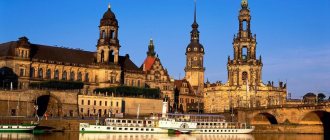
Kazan is the capital of the republic
The cities of Tatarstan should begin to be represented from its capital - Kazan. Presumably this city was founded around the year 1000, during the existence of the Bulgarian kingdom. But the city reached its real prosperity during the Golden Horde. And, especially after the separation of the lands of the middle Volga region into a separate khanate, the capital of which was Kazan. This state was called the Kazan Khanate. But even after these territories were annexed to the Russian kingdom, the city did not lose its significance, remaining one of the largest centers of Russia. After the formation of the USSR, it became the capital of the Tatar Autonomous Soviet Socialist Republic, and after its collapse it became the capital of the Republic of Tatarstan, which is a subject of the Russian Federation.
The city is located on an area of 425.3 square meters. km and has a population of 1.217 million inhabitants, the density of which is 1915 people/1 sq. km. Since 2002, the dynamics of changes in the number of people living in Kazan has had a constant upward trend. Among the ethnic groups, Russians and Tatars predominate, accounting for 48.6% and 47.6% of the total population, respectively. There are much fewer representatives of other nationalities, among which the Chuvash, Ukrainians and Mari should be highlighted. Their share in the total population does not even reach 1%.
Among the religions, Sunni Islam and Orthodox Christianity are the most widespread.
The basis of the city's economy is the petrochemical and engineering industries, but, as in any large center, many other manufacturing sectors, as well as trade and services, are developed.
Kazan is the largest city in Tatarstan. A photo of this important center in the European part of Russia is located above. As you can see, this settlement has a modern appearance.
Area and territories
Assessing the area of this region of the Russian Federation, it is worth highlighting the following facts:
- The total area is 67,847 sq. km.
- Thus, the republic ranks 44th among all other regions of the Russian Federation.
The territory contains such natural areas as:
- 2 large rivers - Volga and Kama. The territory is rich in water resources.
- The territory is a plain, which is covered mainly by steppe. And, only 19% of the territory is deciduous forest of oak, aspen, birch, linden and some other types of trees.
- The climate is moderate continental, with hot summers and fairly harsh winters.
- There are quite a lot of mineral resources here, which allows the region’s economy to develop quite dynamically. For example, oil, coal, dolomite, limestone, shale, copper, bauxite are mined here.
Naberezhnye Chelny is a center of mechanical engineering
Speaking about other cities of Tatarstan, one cannot fail to mention Naberezhnye Chelny. The first settlement here was founded by Russians in 1626. Its original name was Chalninsky Pochinok, but then the village was renamed Mysovye Chelny. In 1930, a new renaming took place, as the city began to be called Krasnye Chelny, which had ideological overtones. In addition, nearby was the village of Berezhnye Chelny, which received city status in the same 1930. From the merger of these two settlements Naberezhnye Chelny was formed.
The city developed most intensively in the 1960s–1970s, during the Brezhnev era. It was then that the city-forming enterprise for the production of KamAZ trucks was built. From a small town, Naberezhnye Chelny turned into the second largest settlement in the Tatar Autonomous Soviet Socialist Republic after Kazan. After the death of the General Secretary of the CPSU, in 1982, the city was renamed Brezhnev in his honor. But in 1988, Naberezhnye Chelny was returned to its previous name.
Naberezhnye Chelny is the second settlement in terms of population and area in the region. It covers an area of 171 square meters. km, which accommodates a population of 526.8 thousand people. Its density is 3080.4 people/1 sq. km. Since 2009, the population in the city has been constantly growing.
This is also where the majority of Tatars and Russians live – 47.4% and 44.9%, respectively. More than 1% of the total number are Chuvash, Ukrainians and Bashkirs. There are slightly fewer Udmurts, Maris and Mordovians.
Small towns up to 20 thousand people
Agryz
Population 19,739 people (2016).
Kukmor
Population 17,815 people (2019).
Menzelinsk
Population 17,043 people (2016).
Mamadysh
Population 15,573 people (2016).
Tetyushi
Population 11,410 people (2016).
Bulgarian
Population 8,563 people (2016).
Laishevo
Population 8,361 people (2016).
Innopolis
Population 96 people (2016). The city was founded in 2012.
Nizhnekamsk is the youngest city of Tatarstan
Nizhnekamsk has the title of the youngest city in the republic. The regions of Tatarstan cannot boast of a city that was founded later than it. The construction of Nizhnekamsk was planned in 1958. The beginning of the construction itself dates back to 1960.
Currently in Nizhnekamsk, located on an area of 63.5 square meters. km, home to 236.2 thousand people, which makes it the third most populous city in the region, after Kazan and Naberezhnye Chelny. The density is 3719.6 people/1 sq. km.
Tatars and Russians have approximately equal numbers and make up 46.5% and 46.1%, respectively. There are 3% Chuvash in the city, 1% each of Bashkirs and Ukrainians.
The basis of the city's economy is the petrochemical industry.
Urban-type settlements of Tatarstan
| № | Settlement | Area | Population | Telephone code |
| 1 | Arsk | Arsky district | 19 681 | 84366 |
| 2 | Kukmor | Kukmorsky district | 17 479 | 84364 |
| 3 | Vasilyevo | Zelenodolsk district | 17 420 | 84371 |
| 4 | Kamskie Polyany | Nizhnekamsk district | 15 645 | 8555 |
| 5 | Jalil | Sarmanovsky district | 13 613 | 85559 |
| 6 | Alekseevskoe | Alekseevsky district | 11 615 | 84341 |
| 7 | Urussu | Yutazinsky district | 10 577 | 85510 |
| 8 | Lower Maktama | Almetyevsky district | 10 059 | 8553 |
| 9 | Aksubaevo | Aksubaevsky district | 9 984 | 84 344 |
| 10 | Aktobe | Aznakaevsky district | 9 120 | 85 511 |
| 11 | Rich Subs | Sabinsky district | 8 372 | 84362 |
| 12 | Baltasi | Baltasinsky district | 8 115 | 84368 |
| 13 | Nizhniye Vyazovye | Zelenodolsk district | 8 060 | 84371 |
| 14 | Rybnaya Sloboda | Rybno-Slobodsky district | 7 755 | 84361 |
| 15 | Apastovo | Apastovsky district | 5 306 | 84376 |
| 16 | Karabash | Bugulminsky district | 4 955 | 85514 |
| 17 | Kama Ustye | Kamsko-Ustinsky district | 4 496 | 84377 |
| 18 | Kuibyshevsky Zaton | Kamsko-Ustinsky district | 2 644 | 84377 |
| 19 | Tenishevo | Kamsko-Ustinsky district | 762 | 84377 |
Almetyevsk is one of the oldest cities in Tatarstan
But the first settlement on the territory of modern Almetyevsk, on the contrary, was founded relatively long ago. It was originally called Almetyevo, and its foundation dates back to the 18th century. But it received city status only in 1953.
The population of Almetyevo is 152.6 thousand people. It is located on a territorial area of 115 square meters. km and has a density of 1327 people/1 sq. km.
The absolute majority are Tatars – 55.2%. There are slightly fewer Russians – 37.1%. Next in number are the Chuvash and Mordovians.
New mergers, divisions and ephemeral regions
Since then, the number of districts of the Tatar Autonomous Soviet Socialist Republic began to decrease. In 1954, the Kornoukhovsky, Matveevsky and Mortovsky districts were abolished. A year later, the Novopismyansky district was renamed Leninogorsky. In 1956, Podberezinsky, Churilinsky, Yukhmachinsky and Yamashinsky districts were abolished. Kzyl-Yulsky district was renamed Tukaevsky. In 1957, two more districts were renamed: Budenovsky to Tsilninsky and Voroshilovsky to Yana-Yulsky. A year later, three more districts were renamed: Tsipyinsky to Baltasinsky, Yudinsky to Zelenodolsky, Yutazinsky to Urussky. In the same year, the Kzyl-Armeisky, Telmansky, Tenkovsky and Tumutuksky districts were abolished.
In 1959, the Aktash, Atninsky, Bolshetarkhansky, Kalininsky, Kzyl-Yulduzsky, Stolbishchensky, Tyulyachinsky, Tsilninsky, Shugurovsky and Yana-Yulsky districts were abolished. In 1960, the Krasnoborsky and Kuznechikha districts were abolished, and in 1963 - Agryzsky, Aznakaevsky, Aksubaevsky, Aktanyshsky, Alekseevsky, Alkeevsky, Apastovsky, Bavlinsky, Baltasinsky, Bilyarsky, Bondyuzhsky, Verkhneuslonsky, Vysokogorsky, Drozhzhanovsky, Dubyazsky, Zainsky, Kaybitsky, Kamsko-Ustinsky , Kukmorsky, Laishevsky, Muslyumovsky, Novosheshminsky, Nurlatsky, Pervomaisky, Rybno-Slobodsky, Takanyshsky, Tukaevsky, Urussky and Sheremetyevsky.
Already at the end of 1963, the process of restoring the abolished districts began: the first of them was the Aznakaevsky district. In 1964, Agryzsky, Alekseevsky, Alkeevsky and Apastovsky districts were formed, and in 1965 - Aksubaevsky, Aktanyshsky, Bavlinsky, Baltasinsky, Verkhneuslonsky, Vysokogorsky, Kamsko-Ustinsky, Kukmorsky, Laishevsky, Muslyumovsky, Nizhnekamsky, Rybno-Slobodsky and Cheremshansky.
The Drozhzhanovsky district was formed in 1966, and the Zainsky district in 1972. In 1976, the Chelny district was renamed Tukaevsky. The Novosheshminsky district was formed in 1983, the Mendeleevsky district in 1985, and the Atninsky district in 1990.
After the transformation of the Tatar Autonomous Soviet Socialist Republic into the Republic of Tatarstan (1990), Kaybitsky, Tyulyachinsky and Yutazinsky districts were formed (1991). Kuibyshevsky district was renamed Spassky (1991), and Oktyabrsky district was renamed Nurlatsky (1997).
At the beginning of the issue, we noted the ephemeral republic - the Tatar-Bashkir Soviet. In the history of administrative-territorial division there were also ephemeral regions. On May 8, 1952, two regions were formed on the territory of the Tatar Autonomous Soviet Socialist Republic: Kazan and Chistopol. On February 21, 1953, the third region was established - Bugulma. However, on April 30, all three regions were abolished. The reader can imagine what it was like for newly appointed party and Soviet regional nomenklatura workers to lose their career prospects. Well, let's not worry about them so much.
The Bolsheviks used the new territorial unit "canton", used by General Osip Igelstrom to control the Bashkir and Meshcheryatsky troops
Zelenodolsk - a city on the Volga
The foundation of Zelenodolsk differs from the emergence of most other cities of Tatarstan in that it was founded not by Russians or Tatars, but by the Mari. Its original name was Porat, then it was replaced by Kabachishchi and Paratsk. In 1928 it received the name Zeleny Dol, and in 1932, in connection with its transformation into a city, Zelenodolsk.
The population of the city is 98.8 thousand people. with an area of 37.7 sq. km, and density – 2617.6 people/1 sq. km. Among the nationalities, Russians (67%) and Tatars (29.1%) predominate.
Tatar autonomy: cantons and regions
For the first time, Tatar autonomy with many state attributes was created in June 1920. Initially, the Autonomous Tatar Soviet Republic (it became a familiar TASSR only in 1937) was divided into 10 cantons: Arsky, Bugulma, Buinsky, Laishevsky, Mamadyshsky, Menzelinsky, Sviyazhsky, Spassky, Tetyushsky and Chistopolsky.
In 1921, Agryz, Yelabuga and Chelny cantons were created. Three years later, the Agryz canton was abolished. At the same time, two districts were formed: Agryzsky and Bondyuzhsky.
I must warn the reader that it is in vain to look for some kind of logic in all these administrative-territorial transformations. It was some kind of orgy of zoning: a sea of articles in periodicals, dozens of books and brochures. Each has its own proposals for zoning. Some were quite reasonable and backed up by economic calculations, but the majority had only one argument - “why not?”
In 1927, seven new districts were formed: Voskresensky, Laishevsky, Nurlatsky, Rybno-Slobodsky, Sviyazhsky, Tenkovsky and Ulyanovsky. At the same time, the Laishevsky, Sviyazhsky and Tetyushsky cantons were abolished. Soon Voskresensky district was renamed Kazansky, and Ulyanovsky - Kaybitsky. A year later, the Elabuga canton was abolished.
Map of the TASSR 1928
On July 23, 1930, all cantons of the Tatar Autonomous Soviet Socialist Republic were abolished. Instead of them, the following districts were formed: Aksubaevsky, Aktanyshsky, Aktashsky, Alekseevsky, Alkeevsky, Almetyevsky, Apastovsky, Arsky, Bavlinsky, Bilyarsky, Bugulminsky, Buinsky, Drozhzhanovsky, Dubyazsky, Elabuga, Kamsko-Ustinsky, Krasnoborsky, Kukmorsky, Mamadyshsky, Menzelinsky, Muslyumovsky, Novosheshminsky , Oktyabrsky, Pervomaisky, Pestrechinsky, Sabinsky, Sarmanovsky, Spassky, Takanishsky, Tetyushsky, Tukaevsky, Tumutuksky, Tyuntersky, Chelninsky, Chistopolsky, Sheremetyevsky and Shugurovsky.
In 1931, the Tumutuksky district was renamed Aznakaevsky, the Verkhneuslonsky district was formed, and the Bondyuzhsky, Sviyazhsky and Tenkovsky districts were abolished. A year later, the Takanishsky district was abolished, and Tyuntersky was renamed Baltasinsky.
In 1935, 17 new districts were formed: Bondyuzhsky, Budenovsky, Voroshilovsky, Vysokogorsky, Zainsky, Kalininsky, Kzyl-Armeysky, Kzyl-Yulduzsky, Kzyl-Yulsky, Kuznechikhinsky, Novopismyansky, Takanishsky, Telmansky, Tenkovsky, Tumutuksky, Tyulyachinsky and Yutazinsky. Spassky district was renamed Kuibyshevsky. Three years later, Baltasinsky district was renamed Tsipyinsky, and Tukaevsky - Atninsky. The Kazansky district was abolished, Bolshetarkhansky, Stolbishchensky and Yudinsky districts were formed.
In 1944, Kosteneevsky (soon renamed Mortovsky), Matveevsky, Podberezinsky, Saltanovsky, Churilinsky, Yukhmachinsky and Yamashinsky were formed. Two years later, Saltanovsky district was renamed Kornoukhovsky.
In 1948, the territory of the Tatar Autonomous Soviet Socialist Republic was divided into 70 districts and three cities of republican subordination (Kazan, Zelenodolsk and Chistopol) - this was the apotheosis of the fragmentation of the ATD of the republic.
Map of the TASSR 1930
General characteristics of the cities of Tatarstan
We have studied in detail the largest cities of the Republic of Tatarstan. The largest of them is the capital of the republic, Kazan, with a population of 1.217 million inhabitants. This is the only millionaire city in the republic. Three more settlements in the region have a population exceeding 100 thousand people.
The majority of the population of the cities of Tatarstan are Russians and Tatars. Among other peoples there are relatively many Ukrainians, Chuvash, Mari, Udmurts and Bashkirs. The predominant religions are Orthodox Christianity and Islam. In addition, several other religions are common.
Story
In 1921, Agryz, Yelabuga and Chelny cantons were created. After 3 years, the Agryz canton was abolished. At the same time, 2 districts were formed: Agryzsky and Bondyuzhsky.
In 1927, 7 new districts were formed: Voskresensky, Laishevsky, Nurlatsky, Rybno-Slobodsky, Sviyazhsky, Tenkovsky and Ulyanovsky. At the same time, the Laishevsky, Sviyazhsky and Tetyushsky cantons were abolished. Soon Voskresensky district was renamed Kazansky, and Ulyanovsky - Kaybitsky. A year later, the Elabuga canton was abolished.
On July 23, 1930, all cantons of the Tatar Autonomous Soviet Socialist Republic were abolished. Instead of them, the following districts were formed: Aksubaevsky, Aktanyshsky, Aktashsky, Alekseevsky, Alkeevsky, Almetyevsky, Apastovsky, Arsky, Bavlinsky, Bilyarsky, Bugulminsky, Buinsky, Drozhzhanovsky, Dubyazsky, Elabuga, Kamsko-Ustinsky, Krasnoborsky, Kukmorsky, Mamadyshsky, Menzelinsky, Muslyumovsky, Novosheshminsky , Oktyabrsky, Pervomaisky, Pestrechinsky, Sabinsky, Sarmanovsky, Spassky, Takanishsky, Tetyushsky, Tukaevsky, Tumutuksky, Tyuntersky, Chelninsky, Chistopolsky, Sheremetyevsky and Shugurovsky.
In 1931, the Tumutuksky district was renamed Aznakaevsky, the Verkhneuslonsky district was formed, and the Bondyuzhsky, Sviyazhsky and Tenkovsky districts were abolished. A year later, the Takanishsky district was abolished, and Tyuntersky was renamed Baltasinsky.
In 1935, 17 new districts were formed: Bondyuzhsky, Budenovsky, Voroshilovsky, Vysokogorsky, Zainsky, Kalininsky, Kzyl-Armeysky, Kzyl-Yulduzsky, Kzyl-Yulsky, Kuznechikhinsky, Novopismyansky, Takanishsky, Telmansky, Tenkovsky, Tumutuksky, Tyulyachinsky and Yutazinsky. Spassky district was renamed Kuibyshevsky. After 3 years, Baltasinsky district was renamed Tsipyinsky, and Tukaevsky - Atninsky. The Kazansky district was abolished, Bolshetarkhansky, Stolbishchensky and Yudinsky districts were formed.
In 1944, Kosteneevsky (soon renamed Mortovsky), Matveevsky, Podberezinsky, Saltanovsky, Churilinsky, Yukhmachinsky and Yamashinsky were formed. After 2 years, Saltanovsky district was renamed Kornoukhovsky.
In 1948, the territory of the Tatar ASSR was divided into 70 districts and 3 cities of republican subordination (Kazan, Zelenodolsk and Chistopol).
On May 8, 1952, two regions were formed on the territory of the Tatar Autonomous Soviet Socialist Republic: Kazan and Chistopol. On February 21, 1953, the 3rd region was established - Bugulma. However, on April 30, all 3 regions were abolished. Since then, the number of districts of the Tatar Autonomous Soviet Socialist Republic began to decrease.
In 1954, the Kornoukhovsky, Matveevsky and Mortovsky districts were abolished. A year later, the Novopismyansky district was renamed Leninogorsky. In 1956, Podberezinsky, Churilinsky, Yukhmachinsky and Yamashinsky districts were abolished. Kzyl-Yulsky district was renamed Tukaevsky. In 1957, 2 more districts were renamed: Budenovsky to Tsilninsky and Voroshilovsky to Yana-Yulsky. A year later, 3 more districts were renamed: Tsipyinsky to Baltasinsky, Yudinsky to Zelenodolsky, Yutazinsky to Urussky. In the same year, the Kzyl-Armeisky, Telmansky, Tenkovsky and Tumutuksky districts were abolished.
In 1959, the Aktash, Atninsky, Bolshetarkhansky, Kalininsky, Kzyl-Yulduzsky, Stolbishchensky, Tyulyachinsky, Tsilninsky, Shugurovsky and Yana-Yulsky districts were abolished. In 1960, the Krasnoborsky and Kuznechikha districts were abolished, and in 1963 - Agryzsky, Aznakaevsky, Aksubaevsky, Aktanyshsky, Alekseevsky, Alkeevsky, Apastovsky, Bavlinsky, Baltasinsky, Bilyarsky, Bondyuzhsky, Verkhneuslonsky, Vysokogorsky, Drozhzhanovsky, Dubyazsky, Zainsky, Kaybitsky, Kamsko-Ustinsky , Kukmorsky, Laishevsky, Muslyumovsky, Novosheshminsky, Nurlatsky, Pervomaisky, Rybno-Slobodsky, Takanyshsky, Tukaevsky, Urussky and Sheremetyevsky.
Already at the end of 1963, the process of restoring the abolished districts began: the first of them was the Aznakaevsky district. In 1964, Agryzsky, Alekseevsky, Alkeevsky and Apastovsky districts were formed, and in 1965 - Aksubaevsky, Aktanyshsky, Bavlinsky, Baltasinsky, Verkhneuslonsky, Vysokogorsky, Kamsko-Ustinsky, Kukmorsky, Laishevsky, Muslyumovsky, Nizhnekamsky, Rybno-Slobodsky and Cheremshansky.
The Drozhzhanovsky district was formed in 1966, and the Zainsky district in 1972. In 1976, the Chelny district was renamed Tukaevsky. The Novosheshminsky district was formed in 1983, the Mendeleevsky district in 1985, and the Atninsky district in 1990.
After the transformation of the Tatar Autonomous Soviet Socialist Republic into the Republic of Tatarstan (1990), Kaybitsky, Tyulyachinsky and Yutazinsky districts were formed (1991). Kuibyshevsky district was renamed Spassky (1991), and Oktyabrsky district was renamed Nurlatsky (1997).
Source