The small town of Krymsk, Krasnodar Territory, is located at the foot of the main Caucasus ridge on the banks of the Adagum River, a tributary of the Kuban, at a distance of 100 kilometers from Krasnodar. It is the center of the Crimean region. The city has a railway station of the Caucasian Railway, developed infrastructure and a military airfield in close proximity.
Administrative center of the Krymsky district and the Krymsky urban settlement of the Krasnodar Territory
Story
- 1858 - on the site of the abandoned Adyghe village of Khatuyekhabl, the Crimean fortress was built, named after the Crimean infantry regiment.
- 1862 - the village of Krymskaya was formed. One hundred and forty serving soldiers expressed a desire to settle around the fortress. The soldier-settlers were assigned to the Kuban Cossacks and were given plots of land. Later, Cossacks from other villages of the Kuban, settlers from Ukraine, from the southern and central regions of Russia, Moldovans, and Pontic Greeks arrived here.
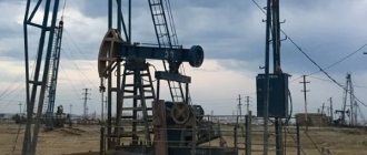
- 1866 - oil production began in the area.
- 1885 - construction of a railway line from Ekaterinodar to Novorossiysk;
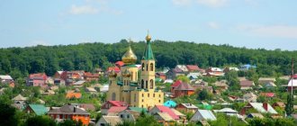
- 1886 - the Church of the Archangel Michael was built;
- 1926 - the Crimean winery was built;
- 1932 - the Krymsky canning plant was built;
- in 1930-1938 - the capital of the Greek National Region.
- August 20, 1942 - May 5, 1943 - occupation by German troops;
- May 28, 1958 - the village received the status of a city and the name Krymsk;
Education
- Crimean Technical College
- Crimean Industrial and Construction College
- Secondary school No. 1 (Komsomolskaya st.)
- Secondary school No. 2 (Lunacharskogo st.)
- Secondary school No. 3 (Sverdlov St.)
- Secondary school No. 5 (25) (Sverdlova st.)
- Secondary school No. 6 (Temchenko street)
- MBOU Gymnasium No. 7 (Fadeeva St.)
- Secondary school No. 9 (Lunacharskogo st.)
- Secondary school No. 20 (Privokzalnaya st.)
- Secondary school No. 24 (Lenin St.)
- Secondary school No. 25 (Sverdlov St.)
Culture, sights
- Remains of the ramparts of the Crimean fortress
- The Karagodeuashkh mound is the burial of a Meotian leader of the last quarter of the 4th century BC. e. (researched in 1888 by E. D. Felitsyn). Gold jewelry, silver vessels, black-lacquer ceramics, amphorae and other relics discovered in the tomb are kept in the Hermitage.
- Museum of Local Lore
- Memorial "Hill of Heroes". The monument to the infantry soldier was erected in 1967 on the 22nd anniversary of the Victory of the Soviet people over Nazi Germany. The height of the soldier’s figure is 11.5 m, including the pedestal – 15 m.
- "Granny tower." The village of Kievskoye, Crimean region, is the birthplace of Russian oil; in 1864, Colonel Novosiltsev drilled the first oil well in Russia in the valley of the Kudako River.
- Mud volcano "Sopka Shugo". It is located at the very beginning of the Greater Caucasus mountain system, 5 km southeast of the village of Varenikovskaya, Krymsky district.
- Winemaking state farm "Sauk-Dere". It is located between Novorossiysk and Krymsk. The wine cellars, reaching about three kilometers in length, house the largest collection of wines in Russia: 250 types of vintage wines, about 100 thousand bottles.
- Ethnographic in the village of Fadeevo.
- Source "Holy Hand" in the village of Neberdzhaevskaya.
- Forest planting in the form of giant letters “XXX YEARS OF VICTORY”
- The source of St. Theodosius of the Caucasus in the village of Gorny.
- A two-hundred-year-old giant oak tree in the village of Russky.
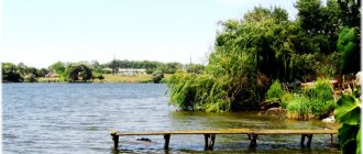
- Varnavinskoye Reservoir. Here you can catch bream, ram, pike perch, sabrefish, silver carp and other fish.
Sport
The Vityaz stadium was built in 1953, but was destroyed during a flood in 2012. “Vityaz” was littered with various debris brought in by the water. The eastern stand, part of the western stand and at least 350 meters of external fences were completely destroyed. An airmobile hospital of the Russian Ministry of Emergency Situations was also deployed at the Vityaz stadium.
Geography
The city is located on the banks of the Adagum River (flows into the Varnavinskoye Reservoir and is connected by canals to the Kuban) in the foothills of the northwestern part of the Main Caucasus Range. It is located 102 km southwest of Krasnodar and 53 km northeast of Novorossiysk.
Junction railway station Krymskaya of the North Caucasus Railway on the Timashevskaya - Krasnodar - Novorossiysk line, direction to Protoka - Starominskaya, branches at the Kavkaz station (ferry to Kerch) and Anapa, Grushevaya.
The nearest civilian airport is in Anapa; there is a military airfield near the city.
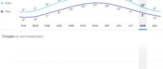
Climate
The climate in Krymsk is moderate continental humid. The average air temperature in July is +30 ºС. Winter: despite the fact that the average temperatures in the winter months in the city are positive, in winter when cold weather fronts pass, the temperature can often drop below −20
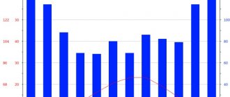
| Climate of Krymsk (average values for the period 1983–2005) | |||||||||||||
| Index | Jan. | Feb. | March | Apr. | May | June | July | Aug. | Sep. | Oct. | Nov. | Dec. | Year |
| Average maximum, °C | 5,8 | 5,4 | 8,4 | 14,0 | 18,9 | 23,0 | 26,8 | 26,5 | 22,0 | 16,9 | 11,2 | 6,9 | 15,5 |
| Average temperature, °C | 3,9 | 3,3 | 6,2 | 11,4 | 16,1 | 20,4 | 24,1 | 23,9 | 19,6 | 14,5 | 9,1 | 5,0 | 13,2 |
| Average minimum, °C | 2,1 | 1,3 | 3,8 | 8,5 | 13,0 | 17,7 | 21,2 | 21,0 | 16,9 | 12,0 | 7,0 | 3,1 | 10,6 |
| Precipitation rate, mm | 98 | 82 | 76 | 71 | 71 | 84 | 65 | 71 | 80 | 102 | 111 | 83 | 975 |
| Source: Meteorological statistics of the Krasnodar region | |||||||||||||
Story
What to see in the city of Krymsk: attractions
The district was formed on June 2, 1924 as part of the Kuban district of the South-Eastern region. It included part of the territory of the abolished Slavic department of the Kuban-Black Sea region. Initially, the district included 28 village councils: Blagodarnensky, Verkhneadagumsky, Verkhnemeretuksky, Volodarsky, Gladkovsky, Gorno-Vesely, Greek, Druzhny, Kievsky, Kotlyarevsky, Krasny, Krymsky, Krymsko-Slobodsky, Leninsky, Lesnoy, Melikhovo, Moldavian, Neberdzhaevsky, Nizhnebakansky , Nizhnemeretuksky, Novoukrainsky, Pavlovsky, Podgorny, Psebepsky, Russian, Garden and Black Sea, Svobodnensky, Quiet.
- Since November 16, 1924, the region has been part of the North Caucasus Territory.
- On October 10, 1925, the Crimean region
was transferred to the Black Sea district. - On February 27, 1930, from part of the territory of the Krymsky district and the Abinsky district of the Kuban district, the Greek national region was formed with its center in the village of Krymskaya.
- On February 16, 1932, the territory of the abolished Abinsk district was included in the district.
- Since January 10, 1934, the region has been part of the Azov-Black Sea Territory.
- On December 31, 1934, the Abinsk region was restored.
- On August 10, 1935, the Crimean region
was abolished, its territory became part of the Greek region. - On February 22, 1938, the Greek district was renamed Krymsky
, and the district center was moved to the village of Krymskaya. - On April 16, 1940, part of the territory of the Krymsky district
became part of the newly formed Varenikovsky district with its center in the village of Varenikovskaya. - On August 22, 1953, part of the territory of the abolished Varennikovsky district
. - On February 11, 1963, the village councils of the Abinsky and abolished Seversky districts became part of the district.
- On February 1, 1963, the Crimean rural district was formed.
- On January 12, 1965, the Abinsky district was restored, and on December 30, 1966, the Seversky district.
- On September 4, 1981, the city of Krymsk was classified as a city of regional subordination and removed from the district, remaining its center.
- In 1993, the activities of rural councils were discontinued, and the territories of rural administrations were transformed into rural districts.
- In 2005, rural district administrations were liquidated in the region and 11 municipalities were formed, including the city of Krymsk.
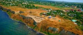
- July 7, 2012 - A devastating flood occurred in the area, killing more than 130 people. In total, 12 thousand people, more than 4 thousand houses, 12 social facilities - schools, kindergartens, two medical warehouses - were in the disaster zone in the region.
Economy
Industry
- Food industry:
- "Crimean Winery", flour milling enterprises.
- Building materials industry:
brick, concrete, large deposits of clay suitable for the production of expanded clay and brick, building stone, quartz sand for glass production.
- production of polypropylene containers.
Sights and culture
Kafa (city)
There are many interesting monuments in the city. On the official website and on Krymsk. ru. You can find information about the sights of Krymsk and photos with their descriptions. These include:
- Memorial "Hill of Heroes". The eleven-meter figure of a soldier - a hero of the Second World War is installed on a high pedestal. The monument was opened on the anniversary of the Victory over Nazi Germany in 1967.
- Kurgan Karagodeuashkh. Dating back to the 4th century BC. e., this is the burial place of the Meotian leader. The discovered relics and artifacts replenished the Hermitage collections.
- The remains of the Crimean fortress built in 1858.
- "Grandma tower." Monument to the first oil well in Russia, drilled in 1864.
- Museum of Local Lore. Introduces you to numerous documents and exhibits of the history of the region and the city. A separate room dedicated to the Second World War displays a panorama of military battles, a collection of weapons, and personal belongings of soldiers and generals.
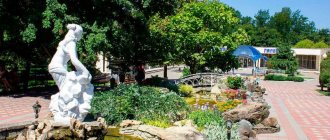
- "Shugo Hill". Mud volcano in the Caucasus Mountains basin. The vast territory contains several dozen small volcanoes at different stages of formation. Some actively spew out warm healing mud. Currently, a recreation area has been created here where you can take mud baths. There are showers and dry closets. In summer you can relax in the cafe. Minibuses and buses run regularly to the volcano.
There are many other interesting places on the territory of the Crimean region:
- State farm winemaking "Sauk-Dere", whose wine cellars store the largest collection of wines in the state.
- Centers of ethnography and history “Caucasian Legends” and “Circassian Village”.
- Source "Holy Handle". The picturesque place in the mountains is perfectly equipped for a summer holiday. Often city residents come with their families for barbecues.
- Tourist office opened in 2015. Here you can book excursions, hire a guide, and find out news about the life of the city and its inhabitants.
Arina Sokolova
This is what Arina Sokolova wrote in her article https://kotenarina.livejournal.com/336013.html
Have you been to hell? I haven't before. So... Krymsk today is a branch of hell on earth. What's happening there is scary. I’ll say right away - I confirm 100% - THERE WAS A WATER DISCHARGE!!!! It's not rain.
In the morning I left Krasnodar for Krymsk, the road to Novoukrainskaya is quite clean. At the entrance to Krymsk there are huge queues of trucks. I asked the drivers why, they don’t know. Besides the fact that the traffic policeman is pulling out of the car. They stand like this for the second day.
When driving onto the bridge, there were torn out pieces of asphalt that were carried around like sheets of paper. There is partially no asphalt near the railings. Fuel oil is spilled on the road, the smell is clearly noticeable. Fences with brick pillars lie on the ground, sheets of iron are bent with superhuman strength. It can be seen that there was a wave of water, and this wave was huge. The level of incoming water can be seen in the houses. Many houses have no roofs and walls have collapsed. Inside is a mixture of mud and silt, 30-40 cm thick. I walked through about 26 houses, people themselves asked to go inside and see WHAT IS GOING ON THERE. Furniture, REFRIGERATORS - LIKE TOYS - SCORED IN CORNERS. Things and equipment were taken out into the gardens and orchards. Everything is covered in dirt. There were overturned cars everywhere, the stream was demolishing everything in its path. People cry.. You know.. this is that feeling of fear, hopelessness that you feel physically. Pain. A woman with two sons, 13 and 16 years old, stood for 5 hours on a pyramid of kitchen and coffee tables, watching the water rise, praying just to survive. In the house next door to hers, a grandmother and her daughter drowned. Many victims. The police came at me with a stupid question: what right do I have to take photographs here? Realizing that I couldn’t adequately explain anything to these guys and the situation was not developing in my favor, when they started grabbing the camera strap, I had to voice those whose support I had enlisted, whose support I was officially promised at the time I was in the city, include the fifth speed and retreat through mud and puddles.
Now what I heard personally from the residents of Krymsk. And I will subscribe to every word they say! This is not a situation for them to cheat. There was NO notification! At 10 pm the power suddenly went out. People thought it must have been an accident, without attaching any significance. Between 12:00 am and 01:00 am, a roar suddenly arose, those who were not sleeping jumped out into the street and fell into the water, because... the water was rising and the courtyards were already flooded. The water was rising until about 5 am, then it slowly began to decline.
Population
| Population | ||||||||
| 1939 | 1959 | 1970 | 1979 | 1989 | 1999 | 2002 | 2009 | 2010 |
| 77 181 | 93 351 | 110 600 | 111 944 | 62 859 | 68 551 | 70 576 | 73 563 | 74 761 |
| 2011 | 2012 | 2013 | 2014 | 2015 | 2016 | 2017 | 2018 | 2019 |
| 132 352 | 133 911 | 133 837 | 134 069 | 133 721 | 133 551 | 133 659 | 133 630 | 134 622 |
Network city Tikhoretsk
The population of the Crimean region as of January 1, 2011 is 132.3 thousand people, including 35% who are economically active.
Among the total population, men make up 46.7%, women – 53.3%. The female population of fertile age is 32,883 people (48.6% of the total number of women). Children from 0 to 17 years old - 28,882 (21.6% of the total population), adults - 104,777 people (78.4%). Of the total population, 75,617 (59.6%) are people of working age, 22.3% are pensioners.
National composition
The Crimean region is one of the most multinational regions in terms of the composition of the living population - more than 67 nationalities, among them: Ukrainians, Greeks, Armenians, Belarusians, Moldovans, Bulgarians, Chuvashs, Georgians. The Russian population makes up the largest number.
Court in the case of flood in Krymsk
After the flood in Krymsk, a criminal case was opened, during which the ex-head of the Krymsky district Vasily Krutko , as well as the mayor of Krymsk Vladimir Ulanovsky, . Krutko and Ulanovsky, as well as the ex-head of the Nizhnebakansky rural settlement (Krymsky district) Irina Ryabchenko and acting. the head of the Crimean regional Department for Emergency Prevention Viktor Zhdanov , knowing about the possible occurrence of an emergency, did not notify the population of the danger and did not ensure their evacuation.
All four officials were charged with negligence resulting in death. Krutko, Ulanovsky and Ryabchenko were also accused of official forgery, and Zhdanov of fraud. Ulanovsky, Ryabchenko and Zhdanov did not admit their guilt, Krutko admitted partial guilt.
On August 6, 2013, during the trial, the prosecution asked that Zhdanov, Krutko and Ulanovsky be sentenced to real terms, and Ryabchenko proposed a suspended sentence.
On August 7, 2013, the defense asked the court to acquit all the accused, since their guilt had not been proven.
On August 19, 2013, the court found four officials guilty. On August 21, the operative part of the court decision was announced, according to which Vasily Krutko was sentenced to six years, Vladimir Ulanovsky to 3.5 years, Viktor Zhdanov to 4.5 years in a penal colony. Irina Ryabchenko received a suspended sentence of 3.5 years.
Distance Krymsk Chernomorskoe by car
| Krymsk | ||
| Krymsk - Economic (8 km; 0:06) | ||
| Economic | 8 kilometers | 0:06 |
| Economic - Sadovy (3 km; 0:02) | ||
| Garden | 11 km | 0:09 |
| Sadovyi – Kyiv (3 km; 0:01) | ||
| Kyiv | 14 km | 0:11 |
| Kyiv - Keslerovo (6 km; 0:04) | ||
| Keslerovo | 20 km | 0:15 |
| Keslerovo - Pavlovsky (3 km; 0:02) | ||
| Pavlovsky | 24 km | 0:18 |
| Pavlovsky - Anapa (1 km; 0:01) | ||
| Anapa | 26 km | 0:19 |
| Anapa - Adagum (5 km; 0:03) | ||
| Adagum | 30 km | 0:22 |
| Adagum - Kuban Column (2 km; 0:01) | ||
| Kuban Column | 32 km | 0:24 |
| Kuban Column - Varenikovskaya (1 km; 0:00) | ||
| Varenikovskaya | 33 km | 0:25 |
| Varenikovskaya - Ivanov (19 km; 0:17) | ||
| Ivanov | 52 km | 0:42 |
| Ivanov - Yurovka (2 km; 0:02) | ||
| Yurovka | 54 km | 0:44 |
| Yurovka - Dzhiginka (7 km; 0:07) | ||
| Dzhiginka | 61 km | 0:52 |
| Dzhiginka - Bely (7 km; 0:05) | ||
| White | 68 km | 0:57 |
| Bely - Starotitarovskaya (11 km; 0:06) | ||
| Starotitarovskaya | 79 km | 1:04 |
| Starotitarovskaya - Taman (36 km; 0:31) | ||
| Taman | 115 km | 1:35 |
| Taman - Kerch (31 km; 0:40) | Krasnodar region - Republic of Crimea | |
| Kerch | 146 km | 2:16 |
| Kerch - Chernyakovo (25 km; 0:23) | ||
| Chernyakovo | 171 km | 2:39 |
| Chernyakovo - Fountain (13 km; 0:09) | ||
| Fountain | 185 km | 2:49 |
| Fountain - Leninskoye (9 km; 0:05) | ||
| Leninskoe | 194 km | 2:54 |
| Leninskoye - Lugovoe (15 km; 0:09) | ||
| Lugovoe | 209 km | 3:03 |
| Lugovoye – Erofeyevo (6 km; 0:03) | ||
| Erofeevo | 215 km | 3:07 |
| Erofeevo - Batalnoye (4 km; 0:01) | ||
| Battle | 218 km | 3:08 |
| Batalnoe - Primorsky (13 km; 0:07) | ||
| Seaside | 230 km | 3:16 |
| Primorsky - Beregovoe (7 km; 0:04) | ||
| Beregovoe | 237 km | 3:21 |
| Beregovoe - Near Kamyshi (2 km; 0:01) | ||
| Near Kamyshi | 240 km | 3:23 |
| Near Kamyshi - Feodosia (3 km; 0:01) | ||
| Feodosia | 243 km | 3:24 |
| Feodosia - Solnechnoe (3 km; 0:01) | ||
| Sunny | 246 km | 3:26 |
| Solnechnoye - Nasypnoye (4 km; 0:02) | ||
| Bulk | 250 km | 3:29 |
| Nasypnoye – Klyuchoevoye (9 km; 0:06) | ||
| Key | 259 km | 3:35 |
| Klyuchoevoye - Pervomaiskoe (0 km; 0:00) | ||
| Pervomayskoye | 259 km | 3:36 |
| Pervomayskoe - Izyumovka (3 km; 0:01) | ||
| Izyumovka | 262 km | 3:38 |
| Izyumovka - Old Crimea (3 km; 0:03) | ||
| Old Crimea | 266 km | 3:41 |
| Old Crimea - Grushevka (10 km; 0:07) | ||
| Grushevka | 276 km | 3:49 |
| Grushevka - Opytnoe (7 km; 0:03) | ||
| Experienced | 283 km | 3:53 |
| Experienced - Training (2 km; 0:01) | ||
| Educational | 286 km | 3:54 |
| Educational – Joyful (2 km; 0:01) | ||
| Joyful | 288 km | 3:56 |
| Radostnoye - Russian (7 km; 0:03) | ||
| Russian | 295 km | 4:00 |
| Russian - Bogatoe (2 km; 0:00) | ||
| Rich | 297 km | 4:01 |
| Bogatoye - Chernopolye (11 km; 0:07) | ||
| Chernopillya | 308 km | 4:08 |
| Chernopolye - Belogorsk (3 km; 0:02) | ||
| Belogorsk | 311 km | 4:11 |
| Belogorsk - Crimean Rose (19 km; 0:15) | ||
| Crimean Rose | 330 km | 4:26 |
| Crimean Rose - Zuya (3 km; 0:01) | ||
| Zuya | 333 km | 4:27 |
| Zuya - Trudovoye (14 km; 0:09) | ||
| Labor | 347 km | 4:37 |
| Trudovoye – Akropolis (1 km; 0:00) | ||
| Akropolis | 348 km | 4:37 |
| Akropolis - Simferopol (2 km; 0:02) | ||
| Simferopol | 350 km | 4:40 |
| Simferopol - Ana-Yurt (1 km; 0:00) | ||
| Ana-Yurt | 351 km | 4:40 |
| Ana-Yurt - Molodezhnoe (6 km; 0:05) | ||
| Youth | 357 km | 4:46 |
| Molodezhnoe - Mirnoye (1 km; 0:00) | ||
| Peaceful | 358 km | 4:46 |
| Mirnoye – Beloglinka (2 km; 0:01) | ||
| Beloglinka | 360 km | 4:48 |
| Beloglinka - Molodezhnoe (1 km; 0:00) | ||
| Youth | 361 km | 4:49 |
| Molodezhnoe - Agrarnoye (1 km; 0:00) | ||
| Agrarian | 363 km | 4:50 |
| Agrarian - Gresovsky (0 km; 0:00) | ||
| Graceovsky | 363 km | 4:50 |
| Gresovsky - Komsomolskoye (1 km; 0:01) | ||
| Komsomolskoe | 364 km | 4:51 |
| Komsomolskoe - Sovkhoznoe (1 km; 0:01) | ||
| Sovkhoznoe | 365 km | 4:52 |
| Sovkhoznoye - Ukromnoye (2 km; 0:01) | ||
| Secluded | 367 km | 4:53 |
| Ukromnoye - Rodnikovo (3 km; 0:02) | ||
| Rodnikovo | 370 km | 4:56 |
| Rodnikovo - New World (3 km; 0:01) | ||
| New world | 372 km | 4:58 |
| New World - Shkolnoe (3 km; 0:01) | ||
| School | 375 km | 4:59 |
| Shkolnoe - Skvortsovo (6 km; 0:03) | ||
| Skvortsovo | 381 km | 5:03 |
| Skvortsovo - Chervonoye (12 km; 0:07) | ||
| Chervonoye | 393 km | 5:11 |
| Chervonoye – Chebotarka (2 km; 0:01) | ||
| Chebotarka | 395 km | 5:13 |
| Chebotarka - Orekhovo (3 km; 0:01) | ||
| Orekhovo | 398 km | 5:14 |
| Orekhovo - Saki (3 km; 0:02) | ||
| Saki | 400 km | 5:17 |
| Saki - Yevpatoria (15 km; 0:11) | ||
| Evpatoria | 415 km | 5:28 |
| Evpatoria - Koloski (16 km; 0:14) | ||
| Spikelets | 431 km | 5:42 |
| Koloski - Vorobyovo (10 km; 0:09) | ||
| Vorobyovo | 440 km | 5:52 |
| Vorobyovo - Porfiryevka (2 km; 0:02) | ||
| Porfiryevka | 443 km | 5:54 |
| Porfiryevka - Veselovka (3 km; 0:03) | ||
| Veselovka | 446 km | 5:57 |
| Veselovka - Vnukovo (25 km; 0:25) | ||
| Vnukovo | 471 km | 6:22 |
| Vnukovo - Krasnaya Polyana (4 km; 0:03) | ||
| Krasnaya Polyana | 475 km | 6:26 |
| Krasnaya Polyana - Novoselskoye (18 km; 0:17) | ||
| Novoselskoye | 493 km | 6:44 |
| Novoselskoye - Chernomorskoye (1 km; 0:01) | ||
| Black Sea | 496 km | 6:47 |
Sources:
- Cities of Russia: encyclopedia. M., 1994.
- “On catastrophic rains on the Black Sea coast of the Krasnodar Territory - analysis of the situation” - website of the Hydrometeorological Center of Russia, July 7, 2012.
- “Flood in Kuban: details” - RIA Novosti, July 7, 2012.
- “Flood in Kuban: details” - RIA Novosti, July 7, 2012.
- Website of the Investigative Committee of Russia.
- “The Ministry of Emergency Situations of the Russian Federation confirms information about the death of 171 people in Kuban” - RIA Novosti, July 11, 2012.
- “Insurance billion” - website “Insurance in Russia”, August 6, 2012.
- “Head of the Ministry of Emergency Situations Vladimir Puchkov - “KP”: Who is to blame for the flood in the Kuban, and what help do the victims need” - Komsomolskaya Pravda, July 12, 2012.
- “Fellow Travelers” - “Echo of Moscow”, March 17, 2013.
- Website of the Investigative Committee of Russia.
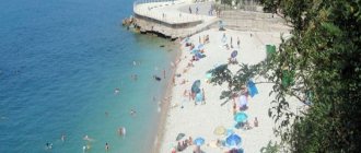
Climate and nature
The favorable location of Krymsk provided it with an excellent climate and ecology. This largely depends on where Krymsk is located on the map. On one side it has the endless Kuban steppes, on the other - the gray Caucasus, on the third - the warm Black Sea. Thanks to this, the city of Krymsk has a temperate continental climate with early spring, late autumn and fairly warm winters. True, January may not spare Krymsk, covering it with snowfalls and frosts, but this phenomenon is short-term and unstable.
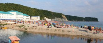
But the summer here is hot, even sultry, so the climate and ecology of Krymsk are excellent for recreation and tourism. The location of the city on the map helps the influx of tourists, especially in those years when, due to the influx of people, the entire infrastructure of the surrounding cities is overloaded. You will definitely like it in Krymsk!
City districts
If you look at the map, which shows a detailed plan, you can see that the whole of Krymsk is divided into districts. Each of them has both advantages and disadvantages, as well as unofficial names:
- Railway Station and Selection Station (OSS);
- Rock;
- Microdistrict;
- Central Market;
- Military City;
- Pig market;
- Greenhouses;
- Secondary school No. 3;
- Secondary school No. 6;
- Secondary school No. 7.
Two districts - the Railway Station and the Experimental Selection Station - are located on both sides of the railway tracks and are densely populated. There is no crossing path, and residents have to go out of town to get home. The busy M4 highway passes through the area, and traffic flows around the clock. In addition to noise, accidents involving pedestrians often occur.
"The Rock" is the largest region of the city, which in the past was intended for migrants. Meskhitian Turks live here. The long Lunacharsky Street runs through the area.
There are only private one-story houses with garden plots; the infrastructure in the region is well developed.
Not far from the center, near the ring road, there is a cozy and quiet Microdistrict. It has all the necessary infrastructure, new supermarkets and multi-storey buildings are being built. Residents farm in the immediate vicinity.
The Central Market area occupies the main part of the city with administrative buildings, shopping malls, medical institutions, gardens, and schools. On the bank of the river, the Crimean “Rublyovka” is being built - the Teplitsy or Slobodka microdistrict. The only school-lyceum in Krymsk was opened here.
On the outskirts is the Pig Market area. In Soviet times, meat was traded here, which is why it got its name. Subsequently, the territory was expanded and they began to sell household goods and spare parts for cars. Nowadays it is the “DIN” car market, but the previous name has been preserved.
Families of military personnel working at the closed airfield live in the Military Town. All the necessary infrastructure is available here. A minibus runs to the city center.