- August 26, 2019
- Directions
- Molton
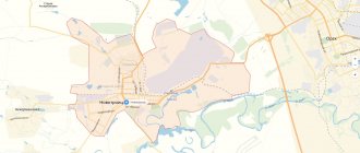
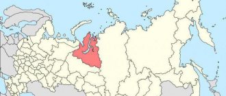
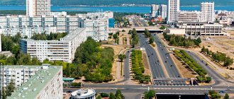
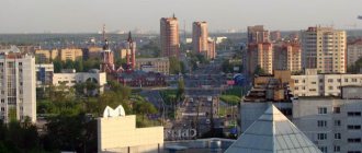
Kemerovo is one of the largest cities in Russia, the center of the Kemerovo region. Where is Kemerovo located? The city is located in the southeast of Western Siberia, in the central part of the Kuznetsk Basin. It is a significant economic, transport, industrial, scientific, cultural and administrative center of the Siberian region. The population is 558,662 people. The city is in 30th place in terms of population among Russian cities. This is the most populated area of the Kemerovo region.
The city ranks 10th in the country in the quality of life ranking. The article gives a description of the city of Kemerovo.
Geographical features
Where is Kemerovo located? The city of Kemerovo is located in the south of Siberia, at a distance of 2987 km (3601 by road) from Moscow. The relief is hilly and ridged, and the landscape zone is Siberian forest-steppe. The city is located along the banks of the river. Tom, being in the zone of its middle course. There are road and railway bridges across the river.
Time in Kemerovo is 4 hours ahead of Moscow. The climate corresponds to where Kemerovo is located. It is continental and quite cold. Winter is harsh and long, lasting from late October to early to mid-April. Summer is warm and humid, and some days can be very hot. At the same time, sudden cold snaps sometimes occur, including frosts and snowfalls.
The annual precipitation is 505 mm. The summer maximum of precipitation is clearly expressed, and the minimum occurs in February and March.
Kemerovo on the map of Russia: geography, nature and climate
Kemerovo on the map of Russia is located in the southeast of Western Siberia , in the center of the Kuznetsk Basin , on both banks of the Tom River and at the mouth of the Iskitimka River .
The area around the city is forest-steppe, on the right bank of the Tom there is a pine forest.
The relief of Kemerovo is a rugged and hilly plain, the average height in the city is 140 meters.
Distance on the map from Kemerovo to major cities by road:
- Novosibirsk – 260 km to the west,
- Omsk – 893 km to the west,
- Tomsk – 218 km to the northwest,
- Anzhero-Sudzhensk – 102 km to the north,
- Krasnoyarsk – 528 km to the northeast,
- Mezhdurechensk – 307 km to the southeast,
- Novokuznetsk – 218 km to the south.
The city's climate is temperate and sharply continental, with cold, long winters and warm, rainy summers. The average annual temperature is +1.5 degrees Celsius. The average temperature in January is -17, and in July – +18 degrees Celsius. There will be approximately 500 mm of precipitation per year.
Population of Kemerovo
The population curve of the city of Kemerovo has a form characteristic of most Russian cities. As in most other regions of the country, until 1990 there was a steady increase in the number of residents, then there was a downward trend, and in the last 10 years there has been slow growth. The total number of people in 2022 was 558,662. This corresponds to 30th place among Russian cities.
The national composition is dominated by Russians (94.6%). In second place, by a large margin, are the Tatars (1.3%). Next come Ukrainians - 0.7%, Armenians - 0.6% and Germans (0.5%).
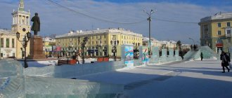
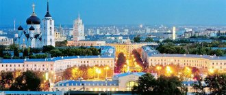
Sights of the city of Kemerovo
- The Church of the Holy Trinity is a beautiful temple, built in 2008 in a modern style. Located in Kuzbass Park, Khimikov Avenue, 32.
- Znamensky Cathedral is a unique church made in the style of Siberian Baroque and Classicism, recognized as a monument of regional significance. Address: Sobornaya street, 24.
- The Church of Xenia of St. Petersburg is a small wooden church with a chapel, reconstructed in 2008. On the map of Kemerovo with streets and houses, this church can be found in the village of Borovoy, on Svyatoy Istochnik Street, 26.
- Coal Museum , displaying examples of mined grades of coal from local coal mines. Here you can also get acquainted with the history of the development of the coal industry in Kuzbass and paleontology. Museum address: Leningradsky Prospekt, 10.
- The monument to the miners of Kuzbass is a sculpture of a working man in a helmet, 12 meters high. Its author is Ernst Neizvestny. The monument was installed on Krasnaya Gorka Street, 17.
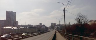
- Kuznetsky Bridge , built across the Tom River and is the second widest (40.5 m) in Siberia after the Oktyabrsky Bridge in Krasnoyarsk. Its length is 638 meters, the traffic on the bridge is six-lane, and trams run in both directions.
- Victory Park , located on the left bank of Iskitimka, along Michurina Street. In the park there are monuments to G.K. Zhukov, home front workers and sculptures of military equipment from the Great Patriotic War.
- Kemerovo Regional Museum of Local Lore is the oldest museum in the region, opened in 1929. Here you can get acquainted with nature, modern and military history of the region, and the memorial complex. The museum is located on Sovetsky Prospekt, 55.
- open-air museum of railway equipment Entrance to the museum is free. Address: Pionersky Boulevard, 1.
Transport network
Within the city limits there are 70 bus routes, 53 taxi routes, 9 trolleybus routes and 5 tram routes. Suburban routes include 63 routes. From this we can conclude that the main mode of transport in Kemerovo is buses. There are 121 electric public transport vehicles, which is quite close to the number of petrol and diesel buses (201 units). Obviously, this should help improve the environmental situation in the city.
The downside is the high level of motorization of the population combined with an unsuitable urban layout. Cars create crowding and traffic jams. Therefore, the development of public transport should be a priority.
The fare is relatively low.
The federal highway P255 passes through Kemerovo. The ring road will reduce the traffic load.
As for the quality of roads, according to motorists, it is the best in the country. Currently, 82% are satisfied with this parameter. However, Kemerovo is rather poorly integrated into the external transport network, which causes dissatisfaction among some residents.
Economy and industry of Kemerovo
The basis of the city's economy is the coal and chemical industries, and mechanical engineering. The largest enterprises in these areas:
- OJSC "UK KuzbassRazrezUgol" and "Ugolnaya" - coal mining;
- OJSC Koks – coke production;
- OJSC "Azot" - production of nitrogen fertilizers and ammonium nitrate;
- FSUE "PO Progress" - production of paint and varnish products;
- JSC "Khimprom" - production of organic and inorganic chemical products;
- State Unitary Enterprise "Kemerovo Mechanical Plant" - production of equipment for agricultural machines.
Electric power and food industry enterprises also play an important role in the city’s economy:
- OJSC "Kemerovo Dairy Plant";
- LLC "AG Kemerovo Meat Processing Plant";
- IP "Volkov Peasant Farm";
- OJSC Kuzbassenergo.
In addition to industry, Kemerovo has developed services, retail trade and banking.
Districts of Kemerovo
Kemerovo is divided into 8 districts: Central, Rudnichny, Kirovsky, Zavodsky, Leninsky, Lesnaya Polyana, as well as 2 suburban villages that are part of the city. The most unfavorable situation is in the Kirov region. Therefore, it is not recommended to live there. And the most prestigious is the residential area of Lesnaya Polyana. There are many cottages and mansions here. This is an area of wealthy and successful people. It also has the best environmental situation in the city.
Map of Kemerovo with streets and houses
- St. Nakhimova is a long (7 km) street in the Rudnichny district, starting at the confluence of Militseiskaya Street with Logovoy Shosse and ending on the outskirts of the city with the highway to Anzhero-Sudzhensk and Mariinsk. The street passes through the private sector, near it there are the Severny Sports Complex and the City Clinical Hospital No. 11.
- Kuznetsky Prospekt on the map of Kemerovo is one of the longest (8 km) and busiest arteries of the city, running through the territory of the Central and Zavodsky districts. The avenue starts from the Tom River and ends in the village of Komissarovo. It contains: a monument to the First Kemerovo tram, the shopping center "Ya" and "City Park", a branch of REU named after. Plekhanov, railway station and bus station.
- Lenin Avenue is the widest highway in Kemerovo (10 lanes), crossing the Zavodsky, Central and Leninsky districts. Its name in the address is: Alexander Nevsky Church, Children's Clinical Hospital No. 1, Antoshka Park and Park named after. Vera Voloshina, Kemerovo Circus, Munira Mosque. The avenue runs entirely through multi-storey residential buildings.
- Gagarin Street is a street in the Zavodsky and Central districts, starting from the embankment of the Iskitimka River. On it are located: St. George's Church and the Znamensky Cathedral, park named after. D. G. Medvedeva, Children's Clinical Hospital No.
- St. Tukhachevsky is a short (2.5 km) street in the Zavodsky district of the city, passing through multi-apartment residential buildings, an industrial zone and ending at the dacha areas on the outskirts of the city.
- St. Krasnoarmeyskaya is a street in the Central and Zavodsky districts, 7 km long. On it there are: the Magnit supermarket, the Dynamo sports complex, the Radio House, Victory Park named after. G. K. Zhukova.
- Shakhterov Avenue - on the map of Kemerovo with streets, it crosses the Rudnichny district and is its main thoroughfare. Trams and trolleybuses also run along the avenue; its length is 5 km. On Shakhterov Avenue you can find: Art College, Mining Court, Peoples' Friendship Park.
Marriages and divorces
The numerical composition of the population in the region in 2022 is affected by the ratio of marriage and divorce. During the 1st half of 2020, 710 marriages were concluded, while in 2022 there were 596. As for divorces - 895 versus 664. In terms of population, it ranks 4th in registration and dissolution of relationships in the Siberian territories.
The desire to annul marriages appears in couples if they entered into a family relationship at a young age and were unable to come to a common agreement in everyday matters. Also, couples who have lived together realize that the feelings have passed, something needs to be changed. Such decisions have a significant impact on the birth rate in Kemerovo throughout 2022. This changes the demographic situation significantly. If there are children, they are raised in single-parent families. Due to the lack of government support, people move to other cities.
Data for the Kemerovo region
Migration
The population percentage of Kemerovo residents in 2022, due to natural decline, decreased by 5,535 people. The region occupies a leading position in this area in Siberia. There is 6.3 natural decline per 100 thousand population of Kuzbass. But in comparison with the migration flow of the population for 2022, the situation has changed for the better, the figures for last year were 6.5. That is, 5,550 people.
Migration processes in the region and a decrease in population in the city and districts occur due to poor ecology and low wages. There are no quotas allocated for state employees and single-parent families; for this reason, people go to other regional centers of Russia. In addition, there is a lack of jobs, no prospects for development and a limited choice of university education.
Gender and age
The distribution by gender and age, how much of the population currently lives in Kemerovo, revealed the following statistics:
- Men – 240,432.
- Women – 297,758.
- Of these, the child population is 115,401.
Data for the Kemerovo region
According to indicators, the population in the territory of Kemerovo is divided into age categories: 3 - 10 years, 27 - 45 years, 57 - 65 years.
Natural movement
Kemerovostat presented a summary statement of the population of Kemerovo for the first six months of 2022 based on the natural movement of residents in all regions of the regional level. The total population of Kuzbass is 2,651,450. Over the past period, the population in the region amounted to 0.4%. As of July 21, 2020, it had decreased to 6,298 people.
The birth rate dropped to 8.4%, which is 9,160 people for the population of Kemerovo in 2022. The mortality rate is reduced to 6.8%, that is, 15,660 people. It follows that statistics on mortality prevail over data on newborns by 72%.