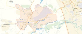
Geographically, Novokuznetsk is divided into 6 districts:
- Kuibyshevsky;
- Central;
- Factory;
- Kuznetsky;
- Ordzhonikidzevsky;
- Novoilinsky.
The current administrative center is located in the Central district of the city, while the historical center is located in the oldest district of the city - Kuznetsky, where Sovetskaya Square and the Kuznetsk Fortress are located. The structure of the location of district streets, as well as the roads connecting them in Novokuznetsk, is quite complex, so for orientation it is better to use a map of Novokuznetsk with streets in good quality.
Airport
The main airport of Novokuznetsk, Spichenkovo, is located approximately 20 kilometers from the city center in a westerly direction between the regional city of Prokopyevsk and the village of Luchshevoy. The air harbor has international status. The airport is capable of receiving aircraft of various classes, including Airbus A320 and Boeing 737-800, and any types of helicopters. The terminal's capacity is about 200 people per hour.
At the moment, Novokuznetsk Spichenkovo Airport serves only Russian airlines. The largest number of flights are operated within Russia. Flights are carried out year-round and every day to Moscow, 2-3 times a week to Novosibirsk and Krasnoyarsk, according to a seasonal schedule - to Sochi, Anapa, Simferopol and other destinations. International flights also operate on a seasonal schedule. The main destinations are Antalya, Cam Ranh and Sanya (Hainan Island).
Spichenkovo Airport can be reached from Novokuznetsk by bus from Oktyabrsky Prospekt. Bus service is also established with Prokopyevsk (the final station is the village of Tyrgan).
Housing stock and architecture. Houses on the map of Novokuznetsk
The city's housing stock is dispersed throughout all districts. In the Kuznetsk region, buildings from Stalin's times predominate with the corresponding architectural design of the facades. “Stalin's houses” are also present in the city center, being architectural monuments that attract tourists. You can find them on almost all the streets of the city center while walking or using a map of Novokuznetsk with houses.
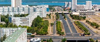
In the Zavodsky and Kuibyshevsky districts, residential buildings are built primarily of brick and are classic Soviet 5-story buildings. The Novoilinsky district is being built up with panel houses and is considered a modern area with a more convenient infrastructure layout. The central district does not have a single architectural style, and its streets often form a complex interweaving, so finding the required address is sometimes only possible using a map of Novokuznetsk with house numbers.
Elite residential real estate is actively being built in Novokuznetsk, located in the Central region (multi-storey complexes) or in suburban areas (cottage communities). The most popular among city residents are the Fregat residential complex, located at the junction of Ordzhonikidze Street and Kuznetskstroevsky Prospekt, new buildings on Ermakov Avenue, as well as luxury high-rise buildings at ul. Tolyatti no. 62 with a view of the city administration. A detailed map of Novokuznetsk will help you find all the luxury real estate objects in the city.
Train Station
The railway station (Novokuznetsk station) is located in the Kuibyshevsky district on Transportnaya Street, 2. Short- and long-distance trains depart from the station electrically (including to foreign countries). Popular year-round routes within Russia are St. Petersburg, Moscow, Kislovodsk, Vladivostok, Tomsk, Tyumen. According to the seasonal schedule, trains depart to Anapa, Sochi and Barnaul. Direct non-stop communication operates with the Kyrgyz capital Bishkek (stops are possible in intermediate settlements in Kazakhstan).
Short-distance electric trains from the Novokuznetsk railway station go to Belovo, Mundybash, Mezhdurechensk, Karlyk, Erunakovo and the Uskorennaya station in Novosibirsk with stops in intermediate settlements.
Transport infrastructure and attractions. Streets on the map
The total length of Novokuznetsk streets reaches 1050 km, with about 760 km of them covered by public transport routes, which can be found on the Novokuznetsk map. The city has 4 large road bridges crossing the Tom River.
The railway and bus stations are located at the junction of the Kuibyshevsky and Central districts on Transportnaya Street.
The main avenues originate from the square in front of the stations:
- Bardina;
- Metallurgists;
- Kurako.
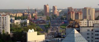
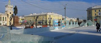
All three avenues are crossed by the central street of the city - Kirov, on which the Administration of Novokuznetsk, the second largest shopping and entertainment complex "City Mall", the Siberian State. university and circus building. Important cultural sites of the city also border Kirova Street: the square for public events, the park named after. Zhukov, Drama Theater and Boulevard of Heroes. All these objects can be easily found on the Yandex map of Novokuznetsk.
The main attraction is the Kuznetsk Fortress, which is an ancient architectural structure with a museum complex located on its territory. The fortress is located in the Kuznetsk district on Krepostny Proyezd, while the nearest public transport stop is about 1 km along the walking route on Lenin Street near Sovetskaya Square. A map of Novokuznetsk with streets and houses will help you find your own route to the Kuznetsk Fortress from the city center.
Among the modern objects that attract the greatest attention of tourists, we can highlight the Planeta shopping center, which is the largest object of this type in the region. The shopping center is located on DOZ street in close proximity to the transport interchange connecting the Central, Kuibyshevsky, Zavodskoy and Novoiliinsky districts. To access the shopping center, special bus routes are organized with routes indicated on the map of Novokuznetsk.
Bus station
The Novokuznetsk bus station is located next to the railway station on Transportnaya Street, 4. The Novokuznetsk bus station is one of the largest transport hubs in the West Siberian region as a whole. Buses depart from here to more than 50 destinations, including international:
- Intersubject routes: Barnaul, Tomsk, Novosibirsk (including a special bus to Tolmachevo airport), Krasnoyarsk, Belokurikha and the Kazakh city of Temirtau.
- Intercity routes: Kemerovo, Benzherep, Kiselevsk, Tashtagol, Osinniki, Mezhdurechensk, Leninsk-Kuznetsky, Guryevsk, Sary-Chumysh, etc.
- Suburban routes: Gavrilovka, Apanas, Novokazankovo, Malinovka, Fedorovka, Prokopyevsk and a number of other settlements.
How to find a plot on the public cadastral map of Novokuznetsk
Information is presented by type of property. To find out publicly available information on a site, you need to enter its cadastral number, location address, or click on the official map of Novokuznetsk and the data will open for you:
- cadastral number;
- appointment;
- registered area;
- for the house, the year of construction;
- location coordinates.
By navigating a cadastral map from a satellite, you can assess the infrastructure surrounding the land plot, adjacent lands and objects.
To expand the list of information received about a land plot or building, here you can also order a report on the property or on the history of the transfer of rights, as well as a certificate of cadastral value.
Automobile highways
There are currently no federal highways connected to Novokuznetsk, but the only ring road in the entire Kemerovo region runs around the city, from which there is a branch to the regional road P366 (connects the city with the southern regions of the Altai Territory).
The Novokuznetsk ring road has 8 exits - at the 0th, 4th, 14th, 25th, 26th, 29th, 31st and 50th kilometer. Thus, you can enter and exit the city in any direction.
Industry and city economy
Novokuznetsk is the largest industrial city in southern Siberia. If you look at a map of Novokuznetsk from a satellite, you can see the huge production areas of the West Siberian Metallurgical Plant, located in the Zavodsky and Kuibyshevsky districts. In addition, the city has an aluminum smelter, a clothing factory, coal mines, machine-building enterprises, electric power facilities, and enterprises in the chemical, food, construction and forestry industries.
The lowest density of industrial facilities is observed in the Novoiliinsky and Tsentralny districts, the highest in the Zavodsky and Kuibyshevsky districts. To find the desired enterprise, you can use a map with the districts of Novokuznetsk.
Taking into account the specifics of the city infrastructure with a wide network of roads, distant locations of attractions, as well as the large area occupied by the city, when developing tourist routes or business trips around Novokuznetsk, a map of Novokuznetsk with streets will be an indispensable assistant.
It is also worth noting that Novokuznetsk airport is located far from the city and it is quite difficult to find the road to it without a map.
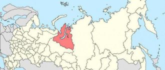
The Novokuznetsk municipal district has disappeared. who is next
Earlier, the editors of VashGorod wrote that deputies voted for the unification of all settlements that are part of the Novokuznetsk municipal district into the Novokuznetsk municipal district. The decision was received ambiguously. Regional authorities saw many advantages from the merger, in particular, cost savings and simplification of the administrative and bureaucratic system. Lawyers also assessed the decision positively, believing that it would save budget money. Social activists, on the contrary, see complete disadvantages.
At the same time, the editorial office of VashGorod received unconfirmed information that the Kuzbass administration is actively discussing the process of further reorganization of municipalities into districts and their consolidation. In particular, the following areas of the central agglomeration can be united: the city of Leninsk-Kuznetsky, Leninsk-Kuznetsky district, Polysayevo, Belovo, Belovsky and Guryevsky districts. At the same time, the village of Krasnobrodsky will go to the Prokopyevsky district.
Our journalists sent a request to the Kuzbass government to clarify the information received. We were told that the Kuzbass authorities did not put forward these initiatives, since the decision to merge municipalities is not within their competence.
“The transformation of municipalities can be carried out on the initiative of the population, local governments, government bodies of the constituent entities of the Russian Federation, and federal government bodies. The state authorities of the Kemerovo region - Kuzbass did not put forward initiatives to transform the municipalities listed in the request,” explained the Kuzbass administration.
However, regional authorities confirmed information that the Krasnobrodsky urban district and the Prokopyevsky municipal district may soon disappear, since relevant initiatives have already been put forward by local governments and are supported by regional authorities. As a result, as a result of the transformation, one new municipal entity will appear.
“As a result of the transformation, the merged Krasnobrodsky urban district and Prokopyevsky municipal district will lose the status of separate municipalities; one new municipal entity will appear,” the Kuzbass administration responded.
Issues of forming local government bodies of the new municipality, according to a representative of the regional administration, will be resolved at the first meeting of the newly elected representative body of the municipal district.
Thus, the process of reorganization and consolidation of municipalities into districts continues. At the same time, regional authorities support this process and evaluate it positively. The editors of VashGorod will continue to monitor the process of reorganization of municipal districts. The dates of the meeting of local self-government bodies on the issue of unification of the Krasnobrodsky urban district and the Prokopyevsky municipal district are still unknown.