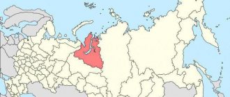
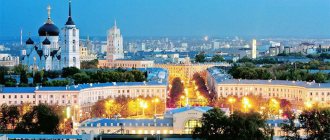
Characteristics of the city of Novotroitsk, Orenburg region
Novotroitsk is a city in the Orenburg region, located in its southern part on the border with Kazakhstan. The city is an important center of ferrous metallurgy in the Urals, so the history of its origin and development is directly related to the discovery of iron deposits:
- the beginning of the 20th century - several farmsteads were formed on the site of the city - Silnov, Akkermanovsky and Beloshapochny;
- 1920s - several families of Ukrainian immigrants found the settlement of Novotroitsk;
- 1929 - discovery of unique iron ore deposits containing chromium, nickel, titanium and manganese near it;
- 1939 – start of construction of the Orsk-Khalilovsky Metallurgical Plant;
- 1945 - the united villages of Novotroitsk and Akkermanovka receive city status;
- 1955 – the first cast iron was produced at the plant.
The population of Novotroitsk has a steady downward trend and amounts to 95 thousand people. Ethnic composition of the population: Russians 90%, Tatars 3%, Kazakhs 3%, Bashkirs 2%, Ukrainians 2%.
How the “fourth district of the city of Orsk” became the city of Novotroitsk
The end of the 30s, women lay sleepers to transport trolleys to the Akkermanovsky mine. Photo from the site “Mysterious Orenburg Region”
Not everyone knows that Novotroitsk, Orsk’s closest neighbor, was for some time part of it and was an Orsk suburb. And during the Great Patriotic War, it almost became the fourth district of Orsk - in any case, the local authorities insisted on this. The archive still contains a letter written in March 1943. It’s called: “On the organization of the 4th administrative district in the city. Orsk".
A letter created in 1943 (for larger photos of all documents, see the bottom of the article in the photo gallery)
Divide and conquer: the history of the emergence of three districts in Orsk
The Orsk authorities were faced with a serious problem: the so-called “new buildings”, that is, the villages of Myasokombinat, Nikel, Kreking, Lokomotiv, CHP - formally belonged to the city, but in fact lived their own lives. There, the heads of enterprises were in charge: they built housing for their workers, brought goods to stores for them, and, after all, provided cultural leisure in the “cultural barracks”... But, of course, that’s what production workers are for: production workers always come first for them there were the needs of industry, and then people. In general, the city authorities had to control all this and keep their finger on the pulse. How to keep her? The City Executive Committee and the City Party Committee were located in the Old City, on Sovetskaya Street. Try to get from there to Nikel, on the other side of the Urals (through which, by the way, the bridge was washed away in the flood, so wait for the ferry)! At the same time, see if everything is okay at Kreking, 7 kilometers from there. And then drop by, say, into the second town of the Meat Processing Plant: there the dispossessed “special contingent” was diagnosed with typhus... All you need to do is cross the river again and drive 15 kilometers off-road. The service Emka was sent to the front, so go, dear official, on a cart...
In general, the dispersion of Orsk greatly complicated (and still complicates, of course) the work of local authorities. Those “at the top” also understood this. And therefore, on February 25, 1943, the Presidium of the Supreme Soviet of the RSFSR issued a decree:
To form three urban districts in the city of Orsk, Chkalov Region, giving them names: Voroshilovsky, Leninsky and Stalinsky.
Alexey Badaev
Chairman of the Presidium of the Supreme Soviet of the RSFSR
By the way, we found the original of this document in the Orsk branch of the state archive, here it is:
Document sent from Moscow in 1942
So, the city was divided like this. The most, let’s say, unpromising area was named after Kliment Voroshilov (the legendary Civil military leader, first marshal of the Union, former People’s Commissar of Defense, in 1942 he served as a representative of the Headquarters for the formation of troops) - the Old Town, the villages of Kirpichny, Vokzalny, Gudron, both meat-packing plant towns. In general, Voroshilovsky is the current Soviet.
City hotel on Sovetskaya Street (in 1942 - Voroshilovsky district of Orsk)
The Leninsky district still exists. In 1942, the villages of Nikel, Pervomaisky, Stroiteley, Lokomotiv (unauthorized development in the area of 6 schools, the village was demolished in the 70s, and the place was built up with high-rise buildings), as well as the village of Oktyabrsky (it was liquidated due to an environmental disaster, we talked about this in one of the previous “old age”). A large territory, many large enterprises went to Vladimir Ilyich...
Workhouse in the village of Nikel (in 1942 - Leninsky district of Orsk)
But still less than Joseph Vissarinovich. The Stalinsky district included the territory of the Chkalovsky oil refinery (together with the village, of course), a brand new thermal power plant, OZTM (which later became YuUMZ), Sotsgorod (that is, the city of the future, New City, then almost deserted, but the most promising area) and... territory of the Orsko-Khalilovsky Metallurgical Plant under construction, that is, the entire current Novotroitsk! In general, the Father of Nations was given an extremely generous gift. True, this generosity, as they say, backfired... But more on that later.
Dividing the city into districts made it possible to better control the life of each remote village: where the city committee cannot reach, the district committee will restore order! This is how the then “head” of Orsk assessed it:
In the mountains Orsk has created 3 urban districts. The experience of industrial enterprises, construction sites and social institutions has shown that in the conditions of newly created areas, the management of industry and construction has come closer and improved, numerous issues of servicing the material and everyday needs of workers are resolved much more specifically and quickly... Practical work of industrial enterprises and construction sites, medical and school institutions, as well as public utility enterprises, has improved... The influence and impact of the party and Soviet apparatus on the nature and conditions of activity of individual enterprises and institutions has come closer.
Konstantin Milovanov
Chairman of the Executive Committee of the Orsk City Council
De facto – independent villages. De jure - suburb
And everything would be fine, but too much territory was rashly allocated to the Stalin region. The fact is that, as mentioned above, all of present-day Novotroitsk was included in it. In general, initially the tiny village of Novo-Troitsky, like the village of Akkermanovsky, belonged to the agricultural Khalilovsky district. But when the Akkerman mine was created (ore was originally mined there for the Orsk nickel plant), and they decided to build a metallurgical plant near Novo-Troitsky (which at first, in fact, they were going to build near Alimbetovka), these small villages were transferred to the Orsky district: he, Unlike Khalilovsky, he was industrial; Orsk officials had a much better understanding of complex industrial issues.
Second half of the 30s, workers at the adit of the Akkerman mine. Photo from the site “Mysterious Orenburg Region”
So: in 1942, both Akkermanovsky and Novo-Troitsky were assigned to the Stalinsky district of Orsk. And again the same problem arose: long distances with poor transport accessibility.
With a population of 57,000 people, the area stretches for 23 km. [The villages] Novo-Troitsky and Akkermanovsky are located from the regional center, the first at a distance of 14 km, the second - at a distance of 21 km, and essentially both of these points ceased to be villages and grew to the level of large populated areas with great economic significance.
Konstantin Milovanov
Chairman of the Executive Committee of the Orsk City Council
In general, Milovanov said, the Stalin district needs to be divided (“disaggregated” - the word of that time) into two. Let Sotsgorod, Kreking, thermal power plant, plant 322 (aka Orsky machine-building plant), bakery and others remain in Stalinsky.
And let enterprises that are located at a distance from Orsk be moved to the “fourth district”. This is the Akkermanovsky mine with a lime quarry, where “the construction of a large cement plant begins,” and OKhMK (Orsko-Khalilovsky Metallurgical Plant - later NOSTA, now Ural Steel). However, at that time OHMK was still under construction, and people worked not so much on it itself, but in OSMC-23. It was the so-called “special construction and installation unit” - one of hundreds of construction organizations created in the USSR during the Great Patriotic War for coordinated, soldier-like precise work in wartime conditions. This same OSMC then employed 9,500 people - imagine the scale of the construction! In addition to the two large objects, there were others in the two villages, smaller ones: a fireclay factory, a sewing and shoe workshop, and others.
War years. OSMC-23 workers are erecting industrial buildings in the Novo-Troitsky village. Photo from the newspaper "Metallurg"
In addition to industrial enterprises, there were also institutions in the “fourth district”. For example, a kindergarten, a nursery, an elementary school, a ten-year school and 2 FZO (factory training schools, later they were reformed into vocational schools). There was a clinic, a “somatic hospital” (that is, therapy), a surgical hospital, an infectious disease clinic, a “children’s and women’s clinic”, a maternity hospital and a children’s sanatorium. It had its own newspaper, a branch of the bank, a branch of the RKM (workers' and peasants' militia) with 12 employees, a people's court and an institution called the “6th precinct of the penitentiary colony” - a branch of the Orsk correctional labor colony: prisoners also worked hard at local construction sites.
That is, Milovanov argued, in fact, the separation of the “fourth district” had already taken place, it was only necessary to legally approve its status:
In the Novo-Troitsky and Akkermanovsky villages, due to their remoteness, a number of institutions have already been created, usually organized in the area... The Executive Committee of the Orsk City Council and the Bureau of the City Committee of the All-Union Communist Party of Bolsheviks considers it expedient and necessary to disaggregate the Stalinsky district of Orsk, forming a new administrative district on based in the villages of Novo-Troitsky and Akkermanovsky.
Konstantin Milovanov
Chairman of the Executive Committee of the Orsk City Council
This letter was sent to Chkalov - present-day Orenburg. From there he was apparently transported to Moscow. And a few months later, the request of the Orsk authorities was granted... But not completely. The remote villages were indeed brought into the district, but it turned out to be not the “fourth district” within Orsk (I wonder what it would be called: Molotovsky? or Zhdanovsky?), but a separate district of regional subordination with a center in the working-class village of Novo-Troitsk. And on April 13, 1945, just before the end of the war, the Presidium of the Supreme Soviet of the RSFSR awarded it the status of a city, removing the hyphen from the name. So the Novo-Troitsky suburb of Orsk became the independent city of Novotroitsk.
Ural56.Ru thanks the branch of the State Budgetary Institution “State Archives of the Orenburg Region” in the city of Orsk and personally the director Inna Ershova, as well as the MAUK “Orsk Local History Museum” and personally the methodologist Anastasia Simonova for their assistance in preparing the material.
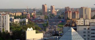
Novotroitsk on the map of Russia: geography, nature and climate
Novotroitsk on the map of Russia is located in the southern foothills of the Urals on the border with Kazakhstan. The distance to the regional center of Orenburg is 276 km. The Ural River flows in close proximity to the city, and in Novotroitsk itself there are the Izvestkovy Log and Maksai streams, and Lake Sazanye. The area around Novotroitsk is steppe, the average height of the city above sea level is 200 meters. Small floodplain forests grow along the banks of the Urals.
The climate of Novotroitsk is moderate, sharply continental, with large amplitudes of annual and daily temperatures. Winter in the city is frosty and snowy, with frequent snowstorms and snowstorms, lasting up to 5 months. Summer is hot and dry, with often recurring dry winds, and lasts approximately 4 months. The average temperature in January is -16, and in July – +21 degrees Celsius. Approximately 320 mm of precipitation falls annually, which is evenly distributed throughout the year.
Economy
The city is located in the Orsko-Khalilovsky industrial region of the Southern Urals. The area, a center of the iron and steel industry, is home to a large steel mill built in the 1950s from nearby iron ore deposits. Chemical production is also important for the region.
The city has a well-developed industry, with twenty large and medium-sized enterprises employing more than 30,000 people. The city's economy is largely determined by industry, which accounts for 95.8% of the total volume of goods and services produced. In 2009, manufacturing enterprises shipped their own products from net activities in the amount of 54.24 billion rubles. The largest share in the volume of shipped products by type of activity “Production” fell on the organization of the metallurgical complex. - 75.3%, in second place is recycling and scrap. - 12.7%, in third - food production, including drinks - 3.8%.
The main enterprise is the metallurgical plant OJSC Ural Steel.
The development of the city and its infrastructure is still determined by the state enterprise Ural Steel, which accounts for almost 90% of all industrial production. The plant is one of the eight largest metallurgical companies in Russia, and ranks 23rd in the ranking of 200 subsidiaries in terms of sales volume. Its product list is very extensive; This is the only enterprise in the world that produces iron ore alloy chromium-nickel alloy with natural casting at its own mines.
Small business has become an integral part of the modern market economic system. There are 660 small enterprises and about 3,000 entrepreneurs without legal entities registered in the city. The number of employees is more than 9,000 people. Today, every fifth city resident lives on income from small businesses.
Routes on the map of Novotroitsk. Transport infrastructure
The Orenburg–Orsk railway passes through Novotroitsk . From the Novotroitsk station, located on Sovetskaya Street, 1, trains depart in the directions Adler - Chelyabinsk, Orenburg - Yekaterinburg, Orsk - Moscow, as well as electric trains Orsk - Orenburg and Orsk - Kuvandyk.
The Novotroitsk bus station is currently not functioning; the nearest bus station is in the neighboring city of Orsk, the distance to which on the satellite map of Novotroitsk is 8 km to the east. From the Orsk bus station there are regular buses to Orenburg, Kuvandyk, Yasny, Adamovka, Magnitogorsk, Ufa and Novotroitsk. His address: Gagarin Square, 1A.
Novotroitsk also does not have its own airport. Orsk International Airport is located 37 km south of Novotroitsk and serves passenger air transportation to Orenburg, Moscow and Svetly.
The city's public transport is represented by 8 bus and 5 tram routes. Suburban buses also depart from Novotroitsk to Akkermanovka, Khabarnoye, Guberlya, Prigornoye and Novonikolsk. The fare on city bus routes is 15 rubles, and on tram routes – 10 rubles.
Culture
There are 27 general educational institutions in the city, including gymnasiums and lyceums, with 15,200 students. There are two colleges, three vocational colleges; Novotroitsk branch of the International Institute of Economics and Law, Novotroitsk branch of the Moscow Institute of Steel and Alloys, as well as the educational and consulting center Magnitogorsk State Technical University, a branch of the Moscow State Open University. The city has six hospitals with a number of hospital beds of about 1,500 each and 5 clinics with a capacity of more than 3,460 visits per shift. More than 500 physicians and 1,500 people work in the nursing field.
There are three dispensaries, a music and art school, a children's art school, a centralized library system with a book fund of 625,000 copies, a Youth Center, a Palace of Culture, a center for the development of children and adolescents, 2 sports stadiums, 1 swimming pool, children's sports schools. Novotroitsk also has a museum and exhibition complex. The museum has two art studios, courses in Arabic language, literature and culture.
The most notable buildings are the city cultural institution "Palace of Culture Industry", built about 50 years ago, the Church of Peter and Paul, built 90 years ago, which is a mosque. The landmark monument is a monument to “live forever”, a monument to internationalist soldiers. Secondary school No. 23 named after the 850th anniversary of Moscow, in its place is a monument to Maria Koretskaya, for the execution near the village of Khabarny. There is a spectacular cinema "Steel".
The general development plan provides for the construction of residential buildings in the southwest of the city. There are five tram routes in the city.
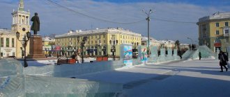
Sights of the city of Novotroitsk
- The Palace of Culture of Metallurgists is the pride of Novotroitsk. Here you can see the Tatar-Bashkir ensemble and show ballet, listen to the veterans' choir and children's pop songs. The building was built in 1963 in the Greco-Roman style. Attraction address: Sovetskaya street, 30.
- Monument to the Cossacks who died for Russia , erected on the highway between Novotroitsk and Orsk. It is made in the form of an Orthodox cross, at the base of which are two St. George crosses - a symbol of honor, valor and courage of the defenders of Russia.
- Peter and Paul Cathedral , built in 2005 in the style of cathedrals of the 15th and 16th centuries. It offers a beautiful view of the surrounding mountains. Located on Sovetskaya street, 127.
- Museum of History and Local Lore , which displays more than 40 thousand exhibits: Tula samovars, military uniforms of the Russian army, pre-revolutionary postcards and archaeological finds of the region. The museum is located on Sovetskaya Street, 82.
- An interesting attraction is the monument called “Eternally Alive” . Nearby there is a site with an eternal flame.
- Monument dedicated to the first builders of the city . It is located on Cheremnykh Street.
- An excellent natural place for outdoor recreation is the coast of the Ural River .
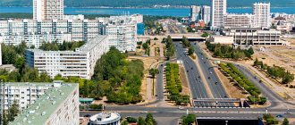
Main streets of Novotroitsk
- st. Sovetskaya is the most important and longest highway in Novotroitsk, starting from Zavodskaya Street on the eastern outskirts of the city and ending in its western part. On this street there is a train station, a park and Metallurgists Square, the Metallurg stadium, city hospital No. 2, a wedding palace and the city administration.
- st. Mira is a street in the Western district of the city, starting from the railway line and ending near the Izvestkovy Log stream. Lyceum No. 1 and the Molodezhny cinema have its name in the address, and in close proximity to it there is a hospital town. The map of Novotroitsk with streets and houses shows that at the beginning of the street. Mira passes through a multi-family residential development, and then through the private sector.
- st. Frunze is a short (less than 1 km) street on the southern outskirts of Novotroitsk, on the left side of which there are multi-storey residential buildings, and on the right side there are mainly educational institutions: Yagodka kindergarten, vocational school No. 34, Novotroitsk branch of MISiS University and Alley Forever Alive.
- st. Zheleznodorozhnaya , running along the railway track through industrial enterprises for ensuring the operation of trains and the Yurga microdistrict. Nearby there is an interesting cultural landmark of the city - the Central City Library named after. Gorky.
- st. Gubina is a small street separating the Western district from the Yurga microdistrict and then turning into st. Lomonosov. Its length is 1 km.
Map
| Novotroitsk: maps |
Novotroitsk: photo from space (Google Maps) Novotroitsk: photo from space (Microsoft Virtual Earth)
| Novotroitsk. Nearest cities. Distances in km. on the map (in brackets along roads) + direction. Using the hyperlink in the distance , you can get the route (information courtesy of the AutoTransInfo website) | |||
| 1 | Orsk | 12 (14) | IN |
| 2 | Guy | 31 (35) | WITH |
| 3 | Novoorsk | 52 (59) | IN |
| 4 | Mednogorsk | 54 (114) | NW |
| 5 | Energetik | 68 (83) | NE |
| 6 | Kuvandyk | 73 (115) | NW |
| 7 | Akyar (Republic of Bashkortostan) | 73 (96) | WITH |
| 8 | Dombarovsky | 98 (110) | SE |
| 9 | Clear | 110 (159) | IN |
| 10 | Komarovsky | 111 () | IN |
| 11 | Adamovka | 118 (139) | IN |
| 12 | Zilair (Republic of Bashkortostan) | 128 (195) | NW |
| 13 | Belyaevka | 132 (170) | Z |
| 14 | Kvarkeno | 138 () | NE |
a brief description of
Located in the Southern Urals, in the Guberlinsky Mountains, on the right bank of the river. Ural, 315 km southeast of Orenburg. Railway station.
Territory (sq. km): 352
Information about the city of Novotroitsk on the Russian Wikipedia site
Historical sketch
It arose as a settlement of peasant migrants from Ukraine at the beginning of the 20th century, called Novotroitsk. There were other small farms nearby: Silnov, Akkermanovsky, Khabarny.
In the fall of 1929, geologist I.L. Rudnitsky discovered the Khalilovskoe deposit of brown iron ore, which was distinguished by a rare composition - it contained chromium, nickel, titanium, and manganese. In June 1931, a decision was made to begin construction of a large metallurgical plant based on Khalilov ores and Karaganda coals. But it was only in 1933 that the design specifications for the construction of the plant were developed. However, in 1935, construction was frozen, apparently due to a lack of funds and labor - the country was building several more large metallurgical plants.
In the spring of 1939, a decree was signed to begin construction of the metallurgical plant. In the summer of 1939, it was decided “to accept the selected Novotroitsk site for the construction of the Khalilovsky Metallurgical Plant...”.
In 1938, the Akkermanovsky mine came into operation.
In the summer of 1942, construction of the first workshops of the metallurgical plant began, and several two-story residential buildings were commissioned.
The city of Novotroitsk since April 13, 1945, was formed by the merger of the working settlements of Novotroitsk and Akkermanovka (PGT since 1938, 2.6 thousand inhabitants, 1939). The name was inherited from the village of Novotroitskaya, which it absorbed, founded by settlers to the Southern Urals from the Russian village of Troitskoye. The population of the city in 1945 reached 17 thousand people.
Municipal indicators
| Index | 1999 | 2001 | 2003 | 2005 |
| Demography | ||||
| Number of births, per 1000 population | 7.7 | 9.3 | 10.3 | 9.2 |
| Number of deaths, per 1000 population | 13 | 15.5 | 16.3 | 17.6 |
| Natural increase (decrease), per 1000 population | -5.3 | -6.2 | -6 | -8.4 |
| Standard of living of the population and social sphere | ||||
| Average monthly nominal accrued wages, rub. | 1840 | 3080 | 4670 | 7457 |
| Average housing area per inhabitant (at the end of the year), sq.m. | 18.8 | 18.7 | 19.6 | 20 |
| Number of preschool institutions, pcs. | 38 | 38 | 38 | 38 |
| Number of children in preschool institutions, thousand people | 4.2 | 4.5 | 4.5 | 4.7 |
| Enrollment of children in preschool educational institutions (at the end of the year), as a percentage of the number of children of the corresponding age, % | 77.7 | 82.3 | ||
| Number of daytime educational institutions (at the beginning of the school year), pcs. | 27 | 27 | 27 | 26 |
| Number of students in daytime educational institutions, thousand people | 15.8 | 14.7 | 12.9 | 11.5 |
| Number of doctors, people. | 518 | 509 | 494 | 478 |
| Number of nursing staff, people. | 1493 | 1424 | 1420 | 1359 |
| Number of hospital institutions, pcs. | 6 | 6 | 7 | 7 |
| Number of hospital beds, thousand units | 1.4 | 1.5 | 1.5 | 1.3 |
| Number of medical outpatient clinics, pcs. | 13 | 11 | 11 | 13 |
| Capacity of medical outpatient clinics, visits per shift, thousand units. | 3.7 | 3.8 | 4 | 3.9 |
| Number of registered crimes, pcs. | 2085 | 2062 | 1837 | 2373 |
| Persons who committed crimes were identified, persons. | 907 | 970 | 815 | 871 |
| Economy, industry | ||||
| Number of enterprises and organizations (at the end of the year), pcs. | 874 | 1010 | 1278 | 1467 |
| Number of operating enterprises by type of activity: mining (at the end of the year), pcs. | 3 | |||
| Number of operating enterprises by type of activity: manufacturing (at the end of the year), pcs. | 58 | |||
| Number of operating enterprises by type of activity production and distribution of electricity, gas and water (at the end of the year), pcs. | 20 | |||
| Volume of shipped goods of own production by type of mining (in actual prices), million rubles. | 207.9 | |||
| Volume of shipped goods of own production by type of manufacturing (in actual prices), million rubles. | 55097.1 | |||
| Volume of shipped goods of own production by type of production and distribution of electricity, gas and water (in actual current prices), million rubles. | 685.7 | |||
| Construction | ||||
| Volume of work performed by type of activity “Construction” (until 2004 - volume of work performed under construction contracts), million rubles. | 138 | 181 | 103 | 32.5 |
| Commissioning of residential buildings, thousand sq.m. of total area | 21.7 | 9 | 5.3 | 9.8 |
| Commissioning of residential buildings, apartments | 286 | 124 | 57 | 116 |
| Commissioning of preschool institutions, places | 0 | 0 | 0 | 0 |
| Commissioning of educational institutions, places | 0 | 0 | 0 | 0 |
| Commissioning of hospital facilities, beds | 0 | 0 | 0 | 0 |
| Commissioning of outpatient clinics, visits per shift | 0 | 0 | 0 | 0 |
| Transport | ||||
| Number of bus routes (in intracity traffic), pcs. | 15 | 18 | 19 | 10 |
| Length of operational tram tracks (at the end of the year), km | 12.9 | 12.9 | ||
| Number of trolleybus routes, pcs. | 0 | 0 | ||
| Number of passengers transported by buses per year (in intracity traffic), million people. | 10.8 | 10.8 | 10.6 | 2.7 |
| Number of passengers transported by trams per year, million people. | 28.3 | 30.7 | ||
| Number of passengers transported by trolleybuses per year, million people. | 0 | |||
| Connection | ||||
| Number of residential telephone sets of the city public telephone network, thousand units. | 24.2 | 25.9 | 27.3 | 29.5 |
| Number of payphones of the city telephone network (including universal ones), pcs. | 124 | 93 | ||
| Trade and services to the population | ||||
| Retail trade turnover (in actual prices), million rubles. | 425.5 | 467.7 | 774.8 | 1073.3 |
| Retail trade turnover (in actual prices), per capita, rub. | 3625 | 3994 | 6851 | 9600 |
| Index of physical volume of retail trade turnover, % compared to the previous year | 111.7 | 114.8 | ||
| Public catering turnover (in actual prices), million rubles. | 129.3 | 101.1 | 123.7 | 219.4 |
| Index of physical volume of public catering turnover, % compared to the previous year | 89.3 | 106.5 | ||
| Number of stores, pavilions (at the end of the year), pcs. | 11 | 4 | ||
| Sales area of shops, pavilions (at the end of the year), sq.m. | 1651.5 | 701.3 | ||
| Volume of paid services to the population (in actual prices), million rubles. | 127.1 | 249.8 | 517.1 | 903.5 |
| Volume of paid services to the population (in actual prices), per capita, rub. | 1082.4 | 2141 | 4572.1 | 8081 |
| Volume of household services to the population (in actual prices), million rubles. | 6.6 | 11.4 | 19.6 | 20.2 |
| Volume of household services to the population (in actual prices), per capita, rub. | 56.2 | 98.1 | 172.9 | 180.9 |
| Investments | ||||
| Investments in fixed assets (in actual prices), million rubles. | 996 | 2349 | 815 | 2192 |
| Share of investments in fixed assets financed from budgetary funds in the total volume of investments, % | 0.1 | 2.3 | 4.7 | 5.7 |
Data sources:
- Regions of Russia. Main characteristics of the constituent entities of the Russian Federation: statistical collection. Goskomstat of Russia. - M:, 2003.
- Regions of Russia. Volume 1. Statistical collection. Goskomstat of Russia. - M:, 2001. p. 358
- Regions of Russia. Basic socio-economic indicators of cities. Statistical collection. Rosstat. - M:, 2005. p. 235
- Transport in Russia: Statistical collection. Goskomstat. - M:, 2003. pp. 110, 120
- Transport in Russia: Statistical collection. Rosstat. - M:, 2005. pp. 117, 127
- Regions of Russia. Basic socio-economic indicators of cities. 2006. Statistical collection. Rosstat. - M:, 2006. p. 239
Economy
Novotroitsk is a major center of ferrous metallurgy in the Southern Urals. JSC "Nosta" - smelting iron, steel, production of rolled products, mineral fertilizers.
Enterprises of the chemical (chromium compounds plant), food (dairy, bakery, food processing plant, poultry farm) industry, production of building materials (factories: cement, silicate wall materials, etc.).
Main enterprises
FERROUS METALLURGY
JSC "Nosta"
462352, Orenburg region, Novotroitsk, st.
Zavodskaya, 1 Offers:
cast iron, rolled ferrous metals, steel billets, bricks, coke
CHEMICAL INDUSTRY
JSC Novotroitsk Chromium Compounds Plant
462351, Orenburg Region, Novotroitsk, st.
Zavodskaya, 1 Offers:
chrome compounds, paint and varnish materials, sodium sulphide
BUILDING MATERIALS INDUSTRY
JSC "Novotroitsk Plant of Silicate Wall Materials"
462352, Orenburg Region, Novotroitsk, Maksai
Offers:
Building bricks; building lime
OJSC Novotroitsk Cement Plant
462352, Orenburg region, Novotroitsk, st.
Zavodskaya, 7 Offers:
Cement
Culture, science, education
Museum of History and Local Lore.
Universities of the city
Novotroitsk branch of the State Technological University "Moscow Institute of Steel and Alloys"
462359, Orenburg region, Novotroitsk, st. Frunze, 8
Museums, galleries, exhibition halls
Museum and exhibition complex of Novotroitsk 462359, Orenburg region, Novotroitsk, st. Sovetskaya, 82 Phone(s)
| Population by year (thousands of inhabitants) | |||||||
| 1959 | 54.5 | 1986 | 104 | 2005 | 104.9 | 2014 | 93.6 |
| 1962 | 69 | 1989 | 106.1 | 2006 | 103.9 | 2015 | 91.6 |
| 1967 | 82 | 1992 | 110.5 | 2007 | 103.2 | 2016 | 89.9 |
| 1970 | 83.4 | 1996 | 110.5 | 2008 | 102.2 | 2017 | 88.2 |
| 1973 | 88 | 1998 | 109.8 | 2010 | 100.9 | 2018 | 86.5 |
| 1976 | 91 | 2000 | 109.6 | 2011 | 98.2 | 2019 | 84.9 |
| 1979 | 94.6 | 2001 | 109.6 | 2012 | 96.5 | 2020 | 83.6 |
| 1982 | 100 | 2003 | 106.3 | 2013 | 95.1 | 2021 | 82.5 |