Where is Kuzbass in Russia? What is this array famous for? You will find answers to these and other exciting questions in our article. We will also look at the sights of the city of Kuzbass. Where is he? More on this later in the article.
Kuzbass is located between the medium-high highlands of the Kuznetsk mountain range and the Salair mountain range, located in the southern part of Western Siberia. Its official name is the Kuznetsk coal basin. Area more than 95 thousand km².
Talking about where Kuzbass is located, I would like to say that its second name is the Kemerovo region, given that the main part of the coal basin belongs to it. The regional center of the region is the city of Kemerovo.
History of the Kemerovo region (Kuzbass)
When talking about where the Kuzbass basin is located, we need to remember its history. Representatives of the Turkic-speaking people (Shors), Siberian Tatars and Teleuts settled on the territory of the modern Kemerovo region several thousand years ago.
In those days, it became necessary to protect this region from external enemies, and at the beginning of the 17th century (in 1618) the Kuznetsk fortress was built. Around it, on the banks of the Tom River (a tributary of the Ob), the future city of Novokuznetsk grew.
Eighty years later, at a distance of 380 km from Kuznetsk, the city of Mariinsk appeared on the Kiya River. According to historical documents, these two cities are considered the oldest cities in the Kuzbass coal basin.
More than 300 years ago, the Emperor of the Russian Empire, Peter I, was informed that an expert in ore mining, the serf Mikhail Volkov, had discovered a coal deposit.
In 1821, the Honorary Member of the St. Petersburg Academy of Sciences, Pyotr Chikhachev, identified large coal deposits in the Kemerovo region, which the scientist called the “Kuznetsk coal basin.”
At the end of the 18th century, coal mining began. After some time, industrial metallurgical and silver smelting enterprises were created.
The Ural industrialist Nikita Demidov became interested in the development of Kuznetsk coal and created a whole network of metallurgical plants. A big impetus for the development of the Kuznetsk basin was the construction in 1898 of the Trans-Siberian Railway (Trans-Siberian - Great Siberian Way).
see also
- Kemerovo region
- Cities of Russia
| [ + ] Cities by regions of Russia | |
| Cities of the North-West (NWFD) | St. Petersburg (and its cities) • Leningrad region (historical Staraya Ladoga) • Arkhangelsk region • Vologda region • Kaliningrad region • Karelia • Komi • Murmansk region • Nenets Autonomous Okrug • Pskov region |
| Cities of the Volga region (Volga Federal District) | Bashkortostan • Volgograd region • Kalmykia • Kirov region • Mari El • Mordovia • Nizhny Novgorod region • Orenburg region • Penza region • Perm region • Samara region • Saratov region • Tatarstan • Udmurtia • Ulyanovsk region • Chuvashia |
| Cities of Southern Russia (SFD) | Sevastopol (including Inkerman) • Republic of Crimea • Adygea • Astrakhan region • Krasnodar region • Rostov region |
| Cities of the North Caucasus (NCFD) | Dagestan • Ingushetia • Kabardino-Balkaria • Karachay-Cherkessia • North Ossetia - Alania • Stavropol Territory • Chechen Republic |
| Cities of the Urals (Ural Federal District) | Kurgan region • Sverdlovsk region • Tyumen region • Khanty-Mansi Autonomous Okrug - Yugra • Chelyabinsk region • Yamalo-Nenets Autonomous Okrug |
| Cities of Siberia (Siberian Federal District) | Altai Republic • Altai Territory • Irkutsk Region • Kemerovo Region • Krasnoyarsk Region • Novgorod Region • Novosibirsk Region • Omsk Region • Tomsk Region • Tyva • Khakassia |
| Cities of the Far East (FEFD) | Amur Region • Buryatia • Jewish Autonomous Region • Trans-Baikal Territory • Kamchatka Territory • Magadan Region • Primorsky Territory • Sakha (Yakutia) • Sakhalin Region • Khabarovsk Territory • Chukotka Autonomous Region |
| see also | Cities of the DPR, LPR, Transnistria, South Ossetia • Regions of Russia • Cities of Russia |
Where is the Kuzbass coal basin located? Its development
Revolutionary events in Russia suspended the activities of Kuzbass factories. But since 1920, restoration work began at all factories, which became state enterprises.
During this period, schools, institutes, theaters were built in cities, museums and many other cultural institutions were opened. In the period from 1931 to 1939, where Kuzbass is located, eight educational institutions, modern for that time in the city, were built.
Until 1942, the regional center was the city of Novokuznetsk. By decision of the USSR government, in 1943, the Kemerovo region with the regional center of Kemerovo was created on the territory where the city of Kuzbass is located, which used to be part of the Novosibirsk region.
Now there are 20 cities in the region. Where Kuzbass is located, there are 58 mines, coal and metallurgical plants and 36 open-pit coal mining enterprises.
In addition, Kuzbass, where all the conditions have been created to be first in the Russian rankings in coal mining and fourth in steel production, has four universities, nine institutes and twenty colleges in various specialties.
Nowadays, Kemerovo and Novokuznetsk are considered large cities in terms of population and area. They are home to more than a million indigenous people.
Content
- 1 Largest cities 500 thousand - 1 million people 1.1 Kemerovo
- 1.2 Novokuznetsk
- 2.1 Prokopyevsk
- 3.1 Mezhdurechensk
- 4.1 Salair
Kemerovo
On the banks of the Bolshaya Kamyshnaya and Tom rivers there is a regional center - Kemerovo - with an area of 280 km².
There was a Russian settlement on the territory of the future administrative center of Kuzbass.
Historical documents indicate that it was formed from the connection of two small villages - Shcheglovo and Kemerovo. This happened in 1734.
In connection with the development of the coal industry, the territory of the village of Kemerovo expanded, and after some time the first buildings of urban infrastructure appeared.
In 1918, the village received city status, and 25 years later the city of Kemerovo was transformed into a regional center.
Now Kemerovo is the center of the Kuzbass region with a developed chemical and food industry. The main enterprises are plants for the production of artificial solid fuel (coke).
Map
| Kemerovo: maps |
Kemerovo: photo from space (Google Maps) Kemerovo: photo from space (Microsoft Virtual Earth)
| Kemerovo. Nearest cities. Distances in km. on the map (in brackets along roads) + direction. Using the hyperlink in the distance , you can get the route (information courtesy of the AutoTransInfo website) | |||
| 1 | Metal site | 8 () | SE |
| 2 | Fireboxes | 30 (32) | Z |
| 3 | Berezovsky | 36 () | WITH |
| 4 | Plotnikovo | 38 (35) | YU |
| 5 | Industrial | 56 (76) | SW |
| 6 | Krapivinsky | 59 (68) | SE |
| 7 | Yashkino | 70 (69) | NW |
| 8 | Leninsk-Kuznetsky | 78 (74) | YU |
| 9 | Anzhero-Sudzhensk | 81 (96) | WITH |
| 10 | Yurga | 82 (106) | NW |
| 11 | Polysayevo | 84 (84) | YU |
| 12 | Taiga | 84 (95) | WITH |
| 13 | Gramoteino | 92 (91) | YU |
| 14 | Yaya | 96 (124) | WITH |
| 15 | Izhmorsky | 99 (135) | WITH |
| 16 | Belovo | 105 (115) | YU |
| 17 | Inskaya | 105 (130) | YU |
| 18 | Toguchin | 108 (180) | Z |
| 19 | Bolotnoe | 111 (124) | Z |
| 20 | New Town | 117 () | YU |
| 21 | Bachatsky | 118 () | YU |
| 22 | Guryevsk | 119 (143) | YU |
a brief description of
The city is located in the foothills of the Kuznetsk Alatau, on the river. Tom, at the confluence of the river. Iskitim, 3482 km east of Moscow. Pier. Railway station. Road junction.
The climate is continental. The average temperature in January is -18, in July +20. Precipitation is 420 mm per year.
Territory (sq. km): 295
Information about the city of Kemerovo on the Russian Wikipedia website
Historical sketch
Kemerovo arose on the site of ancient Russian settlements, near the stronghold for the development of these lands - the Verkhnetomsk fort (founded in 1657, now the village of Verkhotomskoye), through which the road from Tomsk to the Kuznetsk fort passed.
In 1701, on the left bank of the Tom, near the mouth of Iskitim, Shcheglov’s settlement appeared, which later became a village.
In 1859, on the site of modern Kemerovo there were 7 settlements: the village of Shcheglovo (Ust-Iskitimskoye), the villages of Kemerovo (known since 1734), Evseevo, Krasny Yar, Kur-Iskitim (Pleshki), Davydovo (Ishanovo), Borovaya.
The village of Kemerovo was named after the first settlers of Kemerovo and gave the name to the Kemerovo mine that arose there.
In 1907, the first coal mines were built (coal was discovered here in 1721 for the first time in Kuzbass). The development of the village of Shcheglovo began in connection with the construction before 1917 of the Yurga - Kolchugino (modern Leninsk-Kuznetsky) railway with the Topki - Shcheglovo branch.
The year of foundation of the city is considered to be 1918, when the village of Shcheglovskoye was transformed into the city of Shcheglovsk. On November 12, 1928, the village of Kemerovo (since January 23, 1928 - a workers’ village) and a number of other settlements became part of the city of Shcheglovsk.
In 1932, Shcheglovsk was renamed Kemerovo. Since 1943 - the center of the Kemerovo region.
On January 27, 1941, the working village of Stroitel (PGT since 1935) and a number of other settlements entered the city boundaries.
On March 15, 1941, the city was divided into districts: Central, Zavodskoy, Kirovsky and Rudnichny.
In 1962, the village of Pioner (PGT since 1936, 4.5 thousand inhabitants, 1939; 11.7 thousand inhabitants, 1959) became part of the city; in 1982, the territory of the former village of Pioner was excluded from Kemerovo. In 2004, the working village of Pioneer was again within the city of Kemerovo.
On April 5, 1978, the Leninsky district of the city was formed at the expense of part of the territory of the Zavodsky and Central districts.
Municipal indicators
| Index | 1990 | 1999 | 2001 | 2003 | 2005 |
| Demography | |||||
| Number of births, per 1000 population | 12.4 | 8 | 9.3 | 10.4 | 10.5 |
| Number of deaths, per 1000 population | 10.1 | 13.8 | 14.3 | 15.6 | 15.4 |
| Natural increase (decrease), per 1000 population | 2.3 | -5.8 | -5 | -5.2 | -4.9 |
| Standard of living of the population and social sphere | |||||
| Average monthly nominal accrued wages, rub. | 0.348 | 1742 | 3314 | 5506 | 8839 |
| Average housing area per inhabitant (at the end of the year), sq.m. | 15.3 | 17.9 | 18.4 | 18.7 | 19.2 |
| Number of preschool institutions, pcs. | 244 | 160 | 153 | 149 | 150 |
| Number of children in preschool institutions, thousand people | 31.9 | 16.2 | 16.1 | 17.3 | 19.1 |
| Enrollment of children in preschool educational institutions (at the end of the year), as a percentage of the number of children of the corresponding age, % | 67.8 | 69.7 | |||
| Number of daytime educational institutions (at the beginning of the school year), pcs. | 83 | 98 | 100 | 98 | 100 |
| Number of students in daytime educational institutions, thousand people | 70.6 | 70.4 | 64.7 | 56.7 | 49.7 |
| Number of doctors, people. | 4636 | 4905 | 4996 | 5411 | 5480 |
| Number of nursing staff, people. | 8439 | 7024 | 6538 | 7318 | 6886 |
| Number of hospital institutions, pcs. | 23 | 29 | 27 | 27 | 28 |
| Number of hospital beds, thousand units | 9 | 8.3 | 7.7 | 7.6 | 7.9 |
| Number of medical outpatient clinics, pcs. | 49 | 85 | 70 | 68 | 90 |
| Capacity of medical outpatient clinics, visits per shift, thousand units. | 14.6 | 14 | 13.8 | 13.8 | 15.3 |
| Number of registered crimes, pcs. | 11542 | 12980 | 9843 | 12028 | |
| Persons who committed crimes were identified, persons. | 7073 | 7476 | 5443 | 5130 | |
| Economy, industry | |||||
| Number of enterprises and organizations (at the end of the year), pcs. | 13400 | 14444 | 16940 | 19325 | |
| Number of operating enterprises by type of activity: mining (at the end of the year), pcs. | 12 | ||||
| Number of operating enterprises by type of activity: manufacturing (at the end of the year), pcs. | 314 | ||||
| Number of operating enterprises by type of activity production and distribution of electricity, gas and water (at the end of the year), pcs. | 99 | ||||
| Volume of shipped goods of own production by type of mining (in actual prices), million rubles. | 4678.7 | ||||
| Volume of shipped goods of own production by type of manufacturing (in actual prices), million rubles. | 25041 | ||||
| Volume of shipped goods of own production by type of production and distribution of electricity, gas and water (in actual current prices), million rubles. | 11222.1 | ||||
| Construction | |||||
| Volume of work performed by type of activity “Construction” (until 2004 - volume of work performed under construction contracts), million rubles. | 0.312 | 1197 | 2139 | 2844 | 6051.1 |
| Commissioning of residential buildings, thousand sq.m. of total area | 158.8 | 96.9 | 71.9 | 126.4 | 142 |
| Commissioning of residential buildings, apartments | 1267 | 1021 | 1819 | 1951 | |
| Commissioning of preschool institutions, places | 730 | 0 | 0 | 0 | 35 |
| Commissioning of educational institutions, places | 3294 | 0 | 0 | 0 | 0 |
| Commissioning of hospital facilities, beds | 460 | 0 | 0 | 0 | 215 |
| Commissioning of outpatient clinics, visits per shift | 0 | 0 | 132 | 96 | 48 |
| Transport | |||||
| Number of bus routes (in intracity traffic), pcs. | 100 | 116 | 80 | 55 | |
| Number of tram routes, pcs. | 5 | 5 | 5 | 4 | |
| Length of operational tram tracks (at the end of the year), km | 40.3 | 41.6 | 41.6 | ||
| Number of trolleybus routes, pcs. | 6 | 7 | 9 | 11 | |
| Length of operational trolleybus lines (at the end of the year), km | 26.9 | 32.2 | 32.2 | ||
| Number of passengers transported by buses per year (in intracity traffic), million people. | 186.2 | 134.7 | 116.8 | 102.6 | 75 |
| Number of passengers transported by trams per year, million people. | 48.9 | 41 | 42.9 | 36.1 | 42.5 |
| Number of passengers transported by trolleybuses per year, million people. | 20.1 | 25.3 | 29 | 34.3 | 27.7 |
| Connection | |||||
| Number of telephone sets of the city public telephone network, thousand units. | 93.7 | 140.7 | 156.1 | 163.2 | 168.2 |
| Number of residential telephone sets of the city public telephone network, thousand units. | 62.5 | 110.4 | 124.3 | 131.5 | 136.7 |
| Number of payphones of the city telephone network (including universal ones), pcs. | 1590 | 1305 | |||
| Trade and services to the population | |||||
| Retail trade turnover (in actual prices), million rubles. | 1009 | 7771 | 15971 | 27289 | 44318.1 |
| Retail trade turnover (in actual prices), per capita, rub. | 1972 | 14534 | 30168 | 51751 | 84998.3 |
| Index of physical volume of retail trade turnover, % compared to the previous year | 108.6 | 118.7 | |||
| Index of physical volume of public catering turnover, % compared to the previous year | 115.3 | 140.8 | |||
| Number of stores, pavilions (at the end of the year), pcs. | 293 | 264 | |||
| Sales area of shops, pavilions (at the end of the year), sq.m. | 36881 | 85545 | |||
| Volume of paid services to the population (in actual prices), million rubles. | 0.153 | 1872 | 3600 | 5933 | 10152.2 |
| Volume of paid services to the population (in actual prices), per capita, rub. | 0.3 | 3502 | 6801 | 11252 | 19471.1 |
| Volume of household services to the population (in actual prices), million rubles. | 0.032 | 308.1 | 607.8 | 998.6 | 1357.9 |
| Volume of household services to the population (in actual prices), per capita, rub. | 0.056 | 576 | 1148 | 1894 | 2604.4 |
| Investments | |||||
| Investments in fixed assets (in actual prices), million rubles. | 0.436 | 2181 | 4002 | 6030 | 15917.6 |
| Share of investments in fixed assets financed from budgetary funds in the total volume of investments, % | 18.7 | 11.4 | 14.8 | 25.2 | |
Data sources:
- Regions of Russia. Main characteristics of the constituent entities of the Russian Federation: statistical collection. Goskomstat of Russia. - M:, 2003.
- Regions of Russia. Basic socio-economic indicators of cities. Statistical collection. Rosstat. - M:, 2005. p. 323
- Transport in Russia: Statistical collection. Goskomstat. - M:, 2003. pp. 110, 112, 120, 122
- Transport in Russia: Statistical collection. Rosstat. - M:, 2005. pp. 117, 119, 127, 129
- Regions of Russia. Basic socio-economic indicators of cities. 2006. Statistical collection. Rosstat. - M:, 2006. p. 319
Culture, science, education
Institute of Coal, Siberian Branch of the Russian Academy of Sciences.
University. Medical Academy.
Institutes: Kuzbass Polytechnic, technological, food industry, culture. Faculty of Moscow Commercial University, branch of Novosibirsk Agrarian University.
Theatres: drama, operetta, puppet theaters. Philharmonic. Circus.
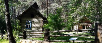
Museums: local history, fine arts. Museum-reserve "Krasnaya Gorka".
Museums, galleries, exhibition halls
Kemerovo Regional Museum of Local Lore 650099, Kemerovo, Sovetsky Ave., 55 Phone(s) Website: https://www.kuzbasskray.ru/
Kemerovo Regional Museum of Fine Arts 650099, Kemerovo, Sovetsky Ave., 48 Phone(s) 36-5033 Website: https://www.kuzbassizo.ru/
Museum-Reserve "Krasnaya Gorka" 650044, Kemerovo, st. Krasnaya Gorka, 17 Telephone(s): inquire. ex.buro Website: https://www.redhill-kemerovo.ru/
Museum "Archaeology, Ethnography and Ecology of Siberia" Kemerovo State University 650043, Kemerovo, st. Krasnaya, 6 Phone(s) Website: https://museum.kemsu.ru/
Museum of Physical Culture and Sports of Kuzbass 65007, Kemerovo, st. Tukhachevsky, 19 Phone(s) Website: https://www.dmps.ru/sport/museum/
Ecomuseum-reserve "Tulber town" 650524, Kemerovo region, Kemerovo district, village. Starochervovo, per. Podgorny, 6 Phone(s) 89059608941 Website: https://tyulber.kemsu.ru/
Architecture, sights
The Tom River divides the city into two parts - the left bank, where the city center is located, and the right bank.
The city grew from separate mining villages, which later merged into a single community.
In the center of the city there is a wide Tom embankment overlooking the Krasnogorsk hills covered with pine forest.
| Population by year (thousands of inhabitants) | |||||||
| 1926 | 21.5 | 1976 | 446 | 2003 | 484.8 | 2015 | 549.2 |
| 1931 | 48.1 | 1979 | 470.6 | 2005 | 522.6 | 2016 | 553.1 |
| 1934 | 110.0 | 1982 | 495 | 2006 | 520.1 | 2017 | 556.9 |
| 1939 | 132.8 | 1986 | 514 | 2007 | 519.8 | 2018 | 559.0 |
| 1956 | 240 | 1989 | 520.3 | 2008 | 520.0 | 2019 | 558.7 |
| 1959 | 277.7 | 1992 | 520.6 | 2010 | 521.2 | 2020 | 556.4 |
| 1962 | 305 | 1996 | 540.8 | 2011 | 533.0 | 2021 | 552.5 |
| 1967 | 364 | 1998 | 497.8 | 2012 | 536.3 | ||
| 1970 | 385.0 | 2000 | 492.7 | 2013 | 540.1 | ||
| 1973 | 415 | 2001 | 489.5 | 2014 | 544.0 | ||
Novokuznetsk
The city of Novokuznetsk, which is more than four hundred years old, used to be called Kuznetsk. It is believed that the history of the city begins in 1617.
That year, a decree was signed by the first Tsar of All Rus', Mikhail Romanov, which required the construction of a wooden fortress in order to establish the power of Russia throughout Siberia.
In connection with this, the Kuznetsk fort was built. Gradually, a settlement grew around the fortress.
The inhabitants of this area were engaged in blacksmithing, making mainly weapons from mined iron. This is where, according to historians, the name of the city came from. Since the 17th century, they were called “Kuznetsk Tatars”, and their place of residence was called “Kuznetsk land”.
Since 1804, the settlement has become a county town. Then he receives an official coat of arms with the image of a forge. In 1927, the city became an all-Union construction site, thanks to which the first metallurgical plant was built.
In 1932, the villages nearby Kuznetsk were united into a single city. It officially received the name "Novokuznetsk".
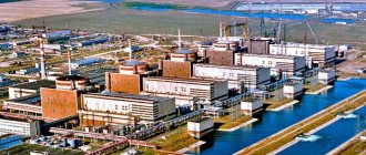
Now it is a modern city with an area of more than 400 km², home to 554 thousand adults, most of whom work at the West Siberian Combine, one of the largest metallurgical enterprises in Europe. Kuzbass is considered the pearl of Siberia.
In 2011, the excursion bureau held a competition among residents of the Kemerovo region, where they had to identify seven places of interest in the Kuzbass region.
This is how the “Seven Wonders of Kuzbass” were defined. This list is the basis of the tourist route for guests and tourists of the Kemerovo region.
Medium-sized cities 20-100 thousand people
Mezhdurechensk
Population 98,734 people (2016).
Leninsk-Kuznetsky
There are and previously existed other settlements with names close to this, see Leninsk
Population 97,666 people (2016).
Kiselevsk
Population 92,210 people (2016).
Yurga
Population 81,396 people (2016).
Belovo
Population 73,400 people (2016).
Anzhero-Sudzhensk
Population 72,827 people (2016).
Berezovsky
Population 47,140 people (2016).
Osinniki
Population 43,445 people (2016).
Myski
Population 41,938 people (2016).
Mariinsk
Population 39,332 people (2016).
Fireboxes
Population 28,144 people (2016).
Polysayevo
Population 26,738 people (2016).
Taiga (city)
Population 24,532 people (2016).
Guryevsk (Kemerovo region)
There are other settlements with this name, see Guryevsk.
Population 23,359 people (2016).
Tashtagol
Population 23,079 people (2016).
Kaltan
Population 21,186 people (2016).
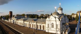
Transfiguration Cathedral
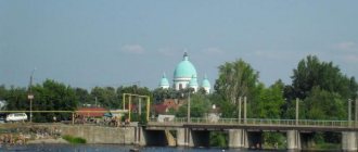
We found out where Kuzbass is located. Now let's talk about the sights of the region. In the old part of the city of Novokuznetsk (190 km from Kemerovo) there is the Transfiguration Cathedral. It is considered the oldest city building.
On the territory of the Kuznetsk fortification (ostrog), near the chapel built in 1618, a church was erected in the name of the Transfiguration of the Lord. In 1791, it was decided to build a stone religious shrine on the site of the wooden temple. In 1835 the cathedral was consecrated. Then it became the main attraction of the city.
Now the church is operational, and city guests can attend the liturgy and view the interior, restored after restoration work.
Cult place “Bald Mountain”
In 1981, librarian Sergei Kuznetsov conducted excavations on the banks of the Golden Kitat River, which is located near the village of Yaya (Yaya district).
This place is a separate, rocky structure without any vegetation. It was a cult place during the Middle Ages.
During the opening of the earth, bone and iron arrowheads, bronze figurines and other objects of that time were found.
Scientists suggest that Bald Mountain was a habitat for spirits for people of the Middle Ages. Then they brought various items to the sanctuary in the form of donations.
History buffs can visit the iconic natural structure as part of excursions organized by the district tourist office.
Ecomuseum "Tazgol"
There is another attraction in the Tashtagol region - the Tazgol open-air ecological museum. It is located in the village of Ust-Anzas.
The museum, created in 1992 by archaeologists together with ethnographers from Kemerovo University, is located on an area of 5 hectares. Monuments of culture and life of the population of the region of past centuries are collected here.
Kuznetsk Fortress
On the territory of Novokuznetsk there is the main attraction of the city - the Kuznetsk Fortress. The fort was built in 1800 on the orders of Russian Emperor Paul I. The bastion is a complex of buildings located on an area of 22 hectares.
The peculiarity of this structure is that throughout its history the fortress did not take part in military events. After 70 years, the citadel was converted into the Kuznetsk prison.
Since 1917, the fortress buildings were used for various city institutions. And after the latest restoration, carried out on the eve of the 390th anniversary of the city, the fort is open to history buffs.
Anzhero-Sudzhensk
This is a very young city, although, however, it is very difficult to even approximately determine its age, since no one undertakes to say when and how the first settlement arose in this remote taiga, which over time became Anzhero-Sudzhensk. Although a couple of legends have survived.
One of them was the legend that an ancient tribe settled in this place. Men, as befits men, hunted and fished, and women were in charge of the house. But it so happened that due to the constant lack of a strong male hand in the village, women took up this matter. They not only cooked and cleaned, but also began to carry out something like modern judicial justice, and from there the name “court of wives” came... - Sudzhenka.
Lakes of Kuzbass. Photo
Where is Kuzbass in Russia? We have already found this out. Note that throughout the Kemerovo region there are hundreds of lakes, mainly floodplain reservoirs (resulting from the laying of new channels by rivers).
Among guests and indigenous residents of the region, Lake Bolshoy Berchikul (Tisulsky district) is considered the most popular for recreation.
There is a legend that says that so many gold nuggets were found here that one of the gold miners exclaimed: “There is so much gold here, take a sack (bag) and collect it!” The combination of these words gave the name to the reservoir, which is considered the largest in area in the region.
Thanks to its unique natural landscape, Bolshoy Berchikul is rightfully included in the list of “Seven Wonders of Kuzbass”.