Solikamsk is one of the oldest cities in the Urals, with enormous tourism potential. At the same time, Solikamsk is the third largest city in the Perm Territory (its population is about 100 thousand people).
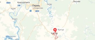
Coordinates for GPS navigator
59.648333, 56.771029
Solikamsk city on the map
As you might guess from the name, the city was founded by salt. In 1430, Vologda merchants Kalinikovs organized salt mines here. On the banks of the Usolka River (a tributary of the Kama), brine-lifting pipes and brewhouses were built for evaporating salt. Now you can clearly understand how everything was arranged in the Borovsky Salt Museum in Solikamsk or in the Khokhlovka Architectural and Ethnographic Museum near Perm.
Thanks to the salt, the settlement quickly grew and developed, soon becoming the salt capital of Russia. Salt was very valuable at that time (no worse than oil today).
The importance of Solikamsk grew greatly with the opening of the Babinovskaya road to Siberia here (a milestone in memory of the Babinovskaya road can now be seen on the city’s Cathedral Square).
In the 20th century, the largest deposits of potassium and potassium-magnesium salts were discovered here. The potash industry is currently the main pillar of the city's economy.
Solikamsk is included in the list of historical cities; it has many cultural and historical attractions, including federal ones. Thousands of people come here every year to see them, including guests from other countries.
Let us dwell on the most interesting sights of the city, among which temples predominate. In total, there are 12 stone churches in Solikamsk, each of them has its own history and its own characteristics; we will tell here only about the most beautiful and interesting ones.
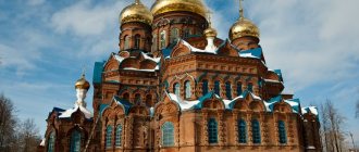
Holy Trinity Cathedral in Solikamsk
This old five-domed cathedral in the historical center of Solikamsk was built in 1684-97.
It was the main temple of the city. A round tile with the image of a double-headed eagle was installed in the southern wall of the temple, and on the western wall there was a relief crown made of brick. Only the crown has survived to this day. The Holy Trinity Cathedral is distinguished by its rich decoration; its stone lace is very beautiful. The two massive porches of the temple are also interesting. In 1929, the temple was closed and a museum was placed here. During the Great Patriotic War, it received valuable evacuated exhibits from the central part of the country. Currently, the history department of the Solikamsk Museum of Local Lore is located here. Museum phone number: +7 (34253) 54518.
Holy Trinity Cathedral is an architectural monument of federal significance, one of the main symbols of Solikamsk.
History of the city of Solikamsk
Source of historical information about the city of Solikamsk: V.V. Kostochkin “Cherdyn, Solikamsk, Usolye.” M. "Stroizdat", 1988
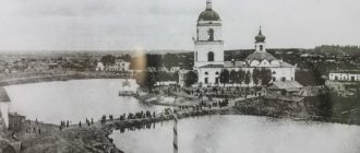
Solikamsk is much younger than Cherdyn. There was a time when the name of this picturesque town, which has now become a major industrial center of the Kama region, was not only written, but also pronounced separately. The largest river in the Urals, the Kama River, and table salt, mined on the Usolka River flowing into it, gave Solikamsk life and a colorful name.
The history of Salt Kamskaya is the history of the development of distant Siberia, the history of the development of the salt industry in Rus' and the development of the natural resources of the vast Perm region.
It is assumed that the foundation of Salt Kama, which later became famous thanks to its rich salt mines, was laid in 1430, when the enterprising townspeople Kalinikovs, who organized the boiling of salt on the Borovitsa River, above the village of Borovoye, due to the weak concentration of the salt brine obtained there, moved their simple fishing equipment to the south, to the shore of Usolka, where the occurrence of salt layers was less deep and the strength of the brine was much higher. At the end of the 15th century, a small fishing village was formed here on Usolka. True, at the beginning of the next century this village was devastated by the Tyumen people, who captured its few inhabitants, but despite this, it quickly resumed its activities, and in 1558 it received wooden fortifications and thereby turned into a city.
In 1559, most of the wooden buildings of Sol Kama burned down, but the city was soon rebuilt. According to the scribal book of Ivan Yakhontov, compiled in 1579, there were 190 philistine households, 26 trading shops, 16 salt pans and 201 inhabitants - people from Vologda, Veliky Ustyug, Ust-Sysolsk, Balakhna and Cherdyn. It then became the center of the vast Usolsky district, the population of which, while boiling salt in the settlement, was also engaged in collecting firewood for the boilers, agriculture, handicrafts and trade. Only the unexpected attack of the Pelym prince Kikhek in 1582, during which the Solikamsk pasad was burned, part of the Solikamsk residents were killed and neighboring villages were destroyed, suspended the life of the city, but its restoration did not last long this time either.
With the final annexation of Siberia and the increased settlement of the Northern and Middle Urals, the number of Solikamsk residents, despite the harsh climatic conditions and low soil fertility, begins to steadily increase. The growth of the salt mining industry in Kamskoye Usolye is increasingly increasing the economic importance of the city. The “sovereign Verkhoturskaya road” has a special influence on its development, which turned Sol Kamskaya into the main transshipment point in front of the Ural ridge. Coachmen appear in it, conducting caravans to Verkhoturye and back, it becomes an important transport hub on the “sovereign Verkhoturye road”.
In 1614, the Moscow government even gave orders to the governor of nearby Cherdyn to carry out repairs to the Solikamsk fortifications, so that “thieves’ people” would not come to “the city and the fort unknown and do something bad.”
At the beginning of the 17th century, the advantageous location of Salt Kama on the “sovereign” road, which firmly connected the center of the country with distant Siberia, affected its development even more strongly. ...
Judging by the scribe book of Mikhail Kaisarov, compiled in 1624, in Solikamsk at that time there were 357 households, 67 shops, 37 varnitsa and more than 620 only male residents.
Sol Kama began to develop especially intensively in the second quarter of the 17th century, after a huge fire in 1635, which destroyed 11 churches and left only a “small matter” in three places on the settlement. Simultaneously with the development of the country's national economy, the city of Solikamsk is also developing. Among Solikamsk salt workers there appear people who are strangers to Solikamsk Posad. Having accumulated funds in the sphere of exchange and trade, they invested money in the Solikamsk salt mines, which were then the main source of wealth of the city and surrounding lands. As a result, the number of salt brewhouses of Kama Salt began to increase rapidly. The administrative role of the city is also expanding. In 1636, the governor’s residence was transferred here, from Cherdyn, to the former Cherdyn “suburb,” and control of the entire region was concentrated.
The industrial development of the city was not affected even by terrible fires, which were the result not only of the lack of basic fire-fighting conditions during salt boiling, but also of deliberate arson, caused either by the revenge of desperate working people, or by the competition of salt industrialists who did not disdain any means to cause damage to their business rivals . They destroyed not only individual streets with their houses, outbuildings, industrial buildings and churches, but also the entire city as a whole. Such a fire in 1672 destroyed the city almost completely.
However, Kama Salt, like a phoenix, always rose from the ashes. According to the census of 1678–1679, in Solikamsk Posad there were 513 households of local residents and 318 huts that belonged to people who came to the city to work. The total number of inhabitants was 2257 males only.
By the end of the 17th century, Sol Kama turned into the largest salt-making center of the state: more than 200 saltworks were already operating in it and its surroundings.
And at the end of the 17th century, when Sol Kama, playing a leading role in the life of the Urals, reached the zenith of commercial and industrial development, large stone construction began there.
Religious buildings were then built mainly from stone (brick). They were placed both in the city center and on its outskirts. Solikamsk residents erected them as usual on the sites of old churches destroyed by fires in 1688 and 1695. These were separate structures, but some of them later became the basis of architectural complexes. Along with richly decorated stone churches, stone residential buildings of wealthy residents also appeared on the streets of Solikamsk.
Such extensive construction as unfolded in Solikamsk at the end of the 17th century had never happened in the Kama region. Having introduced new elements into the artistic appearance of the city, the main buildings of which still remained wooden, it continues at the beginning of the next century, gradually spreading beyond its borders. Thanks to him, the famous salt mine becomes the main center of construction culture throughout the region, the trendsetter of its artistic fashion. It is experiencing the most rapid period of its development. His fame spreads throughout the country. His buildings are known in Moscow and spoken about in the cities of Siberia.
Along with the “stone builders,” local painters also worked in Solikamsk at the beginning of the 18th century, carpenters, joiners and woodcarvers worked, blacksmiths, potters and other artisans produced their products. Their fruitful activity on city construction projects soon attracted the attention of Peter 1, who then began hastily building a new state capital on the Neva. And it is no coincidence that in 1703, by royal decree, Solikamsk blacksmiths were sent to Tikhvin and Taganrog “to the city building”, and in 1710, Solikamsk carpenters, joiners and boilermakers were taken to St. Petersburg construction sites.
Then Peter 1 paid attention to Solikamsk itself, which had already changed greatly. In 1722, by his order, even the “academy teacher” Stepan Zherebtsov was sent to the city, obliged to teach the children of local residents “arithmetic and geometric sciences.” This was the period of the highest development of the “salt capital” of the Russian Empire, the time of its rapid economic recovery and cultural growth. The city at that time already occupied a significant territory and was larger than at the beginning of the 18th century...
Large construction works were carried out in Solikamsk in the third quarter of the 18th century. However, this time they were caused not so much by the growth of the city’s economy, but by two enormous fires that followed each other in mid-1743.
The July fire of 1743 was especially severe, taking 16 lives and destroying 700 town houses, not counting the shopping arcades and the large bridge across Usolka, as well as public buildings. After this fire, which even melted the bells of two churches, only two wooden churches and 20 houses survived in Solikamsk. It was a terrible disaster that caused the departure of many fire victims to Kungur, Stepanovo fortification and Cherdyn... However, rather, the city rose again from the ashes. Not only the courtyards of its eminent residents and the houses of ordinary people were rebuilt, but also all the burnt stone churches, with their chapels and bell towers, were repaired, on which new bells were soon hung; they were specially cast in 1746 and 1747 in Cheboksary.
During this colossal restoration construction, interrupted by smaller fires in 1753 and 1759, the general planning structure of the city began to be streamlined. Its blocks become even more rectangular, its streets and alleys become wider and more rectilinear.
This was also a turbulent period in the construction development of the famous trade, as during the late 17th and early 18th centuries. The construction of the office building in 1781 and the approval of the Solikamsk coat of arms in 1783 (a salt well with a bucket lowered into it on a golden background) were, as it were, its final stage.
However, in the second half of the 18th century, the salt-making industry of Salt Kama, which had developed so much towards the end of the 17th century, no longer played a significant role in the city’s economy. From the beginning of the 18th century, due to the introduction of a state monopoly on salt in 1705 and changes in the conditions of its production and sales, the share of the Solikamsk industry began to rapidly decline. The sharp decline in local salt production was also facilitated by the growth in open-pit extraction of self-planted salt from the Volga lakes Elton and Baskunchak. This led to a decrease in the number of Kama Salt breweries. Some of them were simply not restored after the fires. And if in 1724 there were 44 saltworks in Solikamsk Posad, then in 1743 there were only 34 of them, and in 1760 their number dropped to 23. The city is losing its significance as the main center of Russian salt production, which, due to the creation of a large metallurgical industry, ceases altogether to be the leading site of Russian production, and in 1816 there was no longer a single operating brewery left in it.
With the advent of the new Siberian route, which passed from Kazan through Perm and Kungur to Yekaterinburg, founded in 1721, Solikamsk by the end of the 18th century also lost its significance as a shopping center (it became apart from this route). With the transfer of the provincial chancellery to Kungur in 1738, Solikamsk ceased to be the administrative center of the region.
Today Solikamsk is a major center of modern chemistry, but the city has still retained the basis of the old regular layout.
Epiphany Church in Solikamsk
The five-domed Epiphany Church with a bell tower was built in 1688-95 at the expense of parishioners in the Moscow Baroque style. The facades of the church are decorated with rich stone carvings. In 1934 the church was closed, then in 1943-62 services were held here again. Currently, in the Church of the Epiphany there is a department of ancient Russian art of the Solikamsk Museum of Local Lore. One of the most valuable exhibits is the icon of St. Nicholas, given, according to legend, to the residents of Solikamsk by Ivan the Terrible. Inside the temple, the church decoration has been preserved, and the wooden carved iconostasis has been restored. Here you can see ancient icons of the 17th - 18th centuries. Recently the temple was restored, becoming a real decoration of the city.
How to get to the city of Solikamsk:
The route is designed for standard passenger cars.
The distance from Ekaterinburg is about 570 km, from Perm - about 210 km. You can travel from Yekaterinburg to Solikamsk in two ways:
1) From Yekaterinburg we leave towards Nizhny Tagil. N. Tagil we pass along the bypass road - after passing the town of Verkhnyaya Tura, we follow the signs towards the town of Chusovaya, Perm Territory, focusing on the village of Promysla. Next we pass Promysla - Gremyachinsk - village. Usva - Solikamsk.
2) From Yekaterinburg we leave towards the city of Perm - then we go to the city of Solikamsk.
The distance in both cases is approximately the same, about 570 km..
Combine trip:
Traveling around the Perm region by car.
Voivode's House in Solikamsk
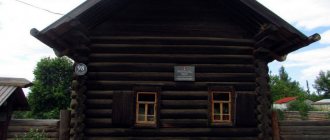
The voivode's stone house, built in 1688, is very interesting. This is the oldest stone civil structure in the Perm region. The thickness of the walls of the house reaches two meters. The building has preserved internal passages and loopholes. In addition, several underground passages led from the governor’s house. Now here is the historical department of the local history museum: here you can get acquainted with the early history of the city and see the interior of the 17th-century executive hut.
Development of transport infrastructure
The total length of roads in Solikamsk is 326.6 km, and with hard surfaces – 261.2 km. A regional highway runs through the city, along which intercity buses travel. Nowadays, motor transport is the main type of intercity transport, which creates a large load on this transport network. Within the city, this was facilitated by the growth in the number of cars and road freight transport.
Therefore, an important direction in the development of the transport network is to improve the quality of intracity roads and carry out timely repairs.
The problem of providing railway transport is also acute. To meet these goals, it is planned to implement a project for the construction of a bypass section of Berezniki and the Belkomur line.
John the Baptist Church
One of the most beautiful churches in Solikamsk is Ioanno-Predtechenskaya (Privokzalnaya St., 32B). It was built in the 18th century in the Russian Baroque style and is memorable for the pronounced upward direction of all architectural elements. Now a convent is being revived at the temple.
St. John the Baptist Church stands in the former village of Krasnoye, surrounded by low houses. Thanks to this contrast and architectural features, it was nicknamed the “church-ship”.
Address: st. Privokzalnaya, 35.
John the Baptist Church
Map of Solikamsk with streets
Geographically, the city is divided into large parts. A map of Solikamsk by district shows the following city layout:
- The Borovsk microdistrict is located in the northern part.
- The southern part of the city stretches along the Usolka River. It houses the bulk of architectural, administrative and cultural monuments. Here you can find buildings dating back to the 19th century. On the territory of the district, a map of Solikamsk with streets and houses will allow you to find the Klestovka, Krasnoye microdistricts, as well as Nizhny and Verkhniy hospital. The villages of Rubtsovo and Kaliets are located nearby.
The districts are located six kilometers apart from each other. This area is occupied by warehouse complexes, industrial zones and garden plots.
The city is a significant transport center. There is a railway station on its territory.
A map of Solikamsk with streets will allow you to find the bus station from which buses depart on suburban and intercity routes.
The city is connected to others via major regional highways.
Road
At the beginning of your trip to Solikamsk you need to get from Moscow to Perm or Yekaterinburg. These large Ural cities have airports, train stations and bus stations.
- From Perm you will have to travel about 200 km, which can be covered in 3 hours by car. The Perm-Solikamsk highway passes through the Chusovsky Bridge; it was erected in the 90s of the last century. Until this time, travelers used water crossings, and drivers stood in hours-long queues for the ferry. You can get to Solikamsk by bus from the central bus station in Perm. Every day more than 20 flights depart in this direction; a ticket costs about 500 rubles.
- From Yekaterinburg to Solikamsk is about 500 km, you can get there in 5 hours by train.
The ancient city with a landscape of salt dumps, in which historical values are carefully protected, surprises with its uniqueness. Having arrived in Solikamsk and having seen all the local attractions, you can take home a sea of positive emotions and photos of the most beautiful monuments of Russian architecture.
Botanical Garden
There is an open botanical garden here. Interestingly, it is located at the latitude of St. Petersburg, in the harsh Ural weather. The garden was founded in 1731 by the Demidov landowners. Plants with unusual names for these places grew in it. However, time has not been kind to the first botanical garden; the current one, grown in a modern city, inherits the good traditions of its ancestor. On Clara Zetkin Street 22, on a plot of land with an area of 6 hectares, trees, flowers and shrubs are planted. In total, about 1,600 species and varieties of plants are collected here; there are more than 600 names of flowers alone.
Recommendations
Notes
- ^ a b c d f g gram
Law No. 416-67 - ^ a b
Federal State Statistics Service of Russia (2011).
“All-Russian Population Census 2010. Volume 1" [All-Russian Population Census 2010, vol. 1]. All-Russian Population Census 2010 [All-Russian Population Census 2010]
(in Russian). Federal State Statistics Service. - "26. The size of the permanent population of the Russian Federation by municipalities as of January 1, 2022.” Federal State Statistics Service. Retrieved January 23, 2022.
- ^ a b c
Law No. 1772-368 - Law No. 1884-410
- "On the calculation of time." Official Internet portal of legal information
(in Russian). June 3, 2011. Retrieved January 19, 2022. - Post office. Information and computing center of OASU RPO. ( Post office
).
Search for postal facilities ( Search for postal facilities
) (in Russian) - Federal State Statistics Service of Russia (May 21, 2004). “The population of Russia, the constituent entities of the Russian Federation as part of federal districts, urban settlements, urban settlements, settlements, settlements of 3 thousand or more people.” [Population of Russia, its federal districts, federal subjects, districts, urban settlements, rural settlements - administrative centers, rural settlements with a population of more than 3000 people] (XLS). All-Russian Population Census of 2002 [All-Russian Population Census of 2002]
(in Russian). - “All-Union Population Census of 1989. The actual population of union and autonomous republics, autonomous regions and districts, territories, regions, urban settlements and villages. On the administrative-territorial structure of the Perm Territory.” Came into force from the moment of publication. Published: “Zvezda”, No. 38, March 12, 1996 (Legislative Assembly of the Perm Region. Law No. 416-67 of February 28, 1996 On the administrative-territorial structure of the Perm Territory
As amended by Law No. 504-PK dated 07/09/2015.
On amendments to the Law of the Perm Region "On the administrative-territorial structure of the Perm Territory"
. Valid from the moment of publication.). - Legislative Assembly of the Perm Region. Law No. 1772-368 of November 10, 2004 “On approval of borders and on granting the status of a municipal entity” City of Solikamsk “Perm Territory”, as amended. Law No. 499-PK of October 16, 2009 “On amendments to the legislative acts of the Perm region and the Komi-Permyak Autonomous Okrug.” Came into force ten days from the date of official publication. Published: “Bulletin of the Legislative Assembly and Administration of the Perm Region”, No. 12, Part I, December 9, 2004 (Legislative Assembly of the Perm Region. Law No. 1772-368 of November 10, 2004. On establishing boundaries and assigning the status of a municipal entity “city” Solikamsk" Perm Territory
As amended by Law No. 499-PK dated October 16, 2009.
On amendments to various legislative acts of the Perm Region and the Komi-Permyak Autonomous Okrug
. Valid from the day that is ten days after the day of official publication.). - Legislative Assembly of the Perm Region. Law No. 1884-410 of December 9, 2004 “On approval of borders and on granting the status of municipalities to the Solikamsk district of the Perm Territory,” as amended. Law No. 470-PK of May 5, 2015 “On amendments to certain Laws of the Perm Region, Komi-Permyak Autonomous Okrug and Perm Territory.” Came into force ten days from the date of official publication. Published: “Rossiyskaya Gazeta”, No. 283, December 22, 2004 (Legislative Assembly of the Perm Region. Law No. 1884-410 of December 9, 2004. On establishing boundaries and assigning status to municipalities of the Solikamsk district of the Perm Territory
. As amended by the Law of 05.05. 2015 No. 470-PK.
On amendments to various laws of the Perm region, Komi-Permyak Autonomous Okrug and Perm Territory
... Valid from the day that is ten days after the day of official publication.).
Spasskaya and Arkhangelsk churches
In ancient times, there was a wooden Kremlin in Solikamsk. Today, only a few buildings have survived on this territory, one of which is the Spasskaya Church (1 May St., 45), erected on the site of a burnt temple at the end of the 17th century. Several years ago, the existing temple was restored, so now it looks elegant and stands out in the city.
Next to Spasskaya there is another church - Archangel Michael (1 May St., 43). This is a very small temple with a single dome in the center, which, although it has survived to this day, is in poor condition and is currently closed for restoration. In addition, the original architectural plan was distorted several times by reconstructions.
The Arkhangelsk Church was heated from the first day, so it worked all year round, but the Spasskaya Church was cold and received parishioners only in the summer.
Address: st. May 1, 43.
Arkhangelsk Church
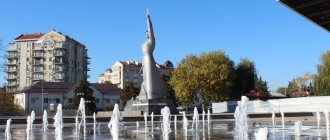
Salt Monument
There is a monument to salt in the central square of the city. The stone pedestal is made in the shape of a towel, on which lies a loaf, and on top there is a salt shaker, as a sign of Russian hospitality.
In addition to it, on the territory of the central square there are 22 cultural monuments that are protected by the state
Accommodation
In Solikamsk and its surroundings there are many hotels, hotels, and holiday homes with different price levels. In the suburbs you can rent a cottage for a large group for 4 thousand rubles. per day, the price of budget hotel rooms starts from 600 rubles. There is a tourist information center in the city, where travelers can get advice on any issue, see photos and descriptions of tourist routes.
Ust-Borovsk salt plant - salt museum
Solikamsk bears its name for a reason.
The city was founded during the salt mines on the banks of the Usolka River. Its name has always been associated with salt: Usolye on Kamskoye, Usolye Kamskoye and even simply - Kamskaya Salt. Today, at the former Ust-Borovsky plant there is a museum where visitors can learn the history of salt production in our country in the 17th-20th centuries, and at the same time explore a unique historical and architectural complex - a monument of wooden architecture in the open air. Address: st. Newspapers Zvezda, 2. Website.
Ust-Borovsk salt plant