Sretensk
(Transbaikal region)
OKATO code:
76240501
Founded:
1689
City since:
1926 City of district subordination (Sretensky district of the Trans-Baikal Territory)
Center:
Sretensky district
Telephone code (reference phone)
| 30246***** | 91-29-2 |
Deviation from Moscow time, hours:
6
Geographic latitude:
52°15′
Geographic longitude:
117°43′
Altitude above sea level, meters:
490 Sunrise and sunset times of the Sun and Moon in the city of Sretensk
Climate
Sretensk has a very continental subarctic climate (Köppen climate classification Dwc
), bordering on a humid continental climate (Köppen climate classification
Dwb
), with severely cold winters and warm summers. Precipitation is quite low, but in summer it is much higher than at other times of the year.
| Climate data for Sretensk | |||||||||||||
| Month | Jan | Feb | Mar | Apr | May | Jun | Jul | Aug | Sep | October | But I | December | Year |
| Record high °C (°F) | 0.2 (32.4) | 3.1 (37.6) | 18.4 (65.1) | 27.3 (81.1) | 33.6 (92.5) | 41.3 (106.3) | 39.7 (103.5) | 36.7 (98.1) | 31.4 (88.5) | 26.7 (80.1) | 11.7 (53.1) | 2.6 (36.7) | 41.3 (106.3) |
| Average high °C (°F) | −22.9 (−9.2) | −15.2 (4.6) | −3.7 (25.3) | 8.4 (47.1) | 17.8 (64.0) | 24.5 (76.1) | 26.2 (79.2) | 23.4 (74.1) | 16.6 (61.9) | 6.6 (43.9) | −9.2 (15.4) | −21.0 (−5.8) | 4.3 (39.7) |
| Daily average °C (°F) | −29.2 (−20.6) | −23.6 (−10.5) | −12.2 (10.0) | 1.2 (34.2) | 9.8 (49.6) | 16.5 (61.7) | 19.1 (66.4) | 16.3 (61.3) | 8.8 (47.8) | −0.8 (30.6) | −15.8 (3.6) | −26.7 (−16.1) | −3.0 (26.6) |
| Average low °C (°F) | −34.6 (−30.3) | −30.7 (−23.3) | −20.2 (−4.4) | −5.7 (21.7) | 2.0 (35.6) | 9.0 (48.2) | 13.1 (55.6) | 10.7 (51.3) | 2.8 (37.0) | −6.7 (19.9) | −21.3 (−6.3) | −31.8 (−25.2) | −9.4 (15.1) |
| Record low °C (°F) | −50.7 (−59.3) | −48.6 (−55.5) | −40.0 (−40.0) | −24.7 (−12.5) | −10.2 (13.6) | −4.0 (24.8) | 0.6 (33.1) | −2.6 (27.3) | −12.5 (9.5) | −29.3 (−20.7) | −41.1 (−42.0) | −48.4 (−55.1) | −50.7 (−59.3) |
| Average precipitation mm (inches) | 3.7 (0.15) | 3.2 (0.13) | 4.7 (0.19) | 12.7 (0.50) | 27.0 (1.06) | 54.9 (2.16) | 97.2 (3.83) | 84.1 (3.31) | 41.9 (1.65) | 12.0 (0.47) | 8.2 (0.32) | 6.2 (0.24) | 355.8 (14.01) |
| Average number of days with precipitation (≥ 0.1 mm) | 6.0 | 4.5 | 4.3 | 5.4 | 7.3 | 11.3 | 14.2 | 13.4 | 9.4 | 5.3 | 7.1 | 8.1 | 96.3 |
| Average relative humidity (%) | 73.4 | 69.3 | 60.0 | 46.8 | 46.6 | 60.4 | 68.6 | 71.4 | 66.3 | 61.5 | 71.2 | 75.1 | 64.2 |
| Average monthly sunshine | 151 | 191 | 246 | 235 | 262 | 261 | 242 | 211 | 193 | 195 | 150 | 120 | 2,457 |
| Source: climbase.ru (1936-2012)[11] Record June)[12] | |||||||||||||
Map
| Sretensk: maps |
Sretensk: photo from space (Google Maps) Sretensk: photo from space (Microsoft Virtual Earth)
| Sretensk Nearest cities. Distances in km. on the map (in brackets along roads) + direction. Using the hyperlink in the distance , you can get the route (information courtesy of the AutoTransInfo website) | |||
| 1 | Kokuy | 11 () | Z |
| 2 | Chernyshevsk | 56 (188) | NW |
| 3 | Shelopugino | 68 (71) | YU |
| 4 | Nerchinsk | 82 (96) | Z |
| 5 | Gazimursky Plant | 89 (161) | SE |
| 6 | Balei | 104 (161) | SW |
| 7 | Shilka | 123 (135) | Z |
| 8 | Vershino-Darasunsky | 148 (207) | Z |
| 9 | Alexandrovsky Plant | 148 (212) | YU |
| 10 | Pervomaisky | 156 (167) | SW |
| 11 | Nerchinsky Plant | 167 (261) | SE |
| 12 | Kalga | 168 (311) | SE |
| 13 | Verkh-Usugli | 178 () | Z |
| 14 | Art. Clear | 206 () | SW |
a brief description of
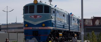
Located in the southeast of Transbaikalia, in the foothills of the Borschovochny ridge, on the banks of the river. Shilka (Amur basin), 385 km east of Chita. Pier on the right bank of the Shilka. Railway station. Road junction.
Territory (sq. km): 82
Information about the city of Sretensk on the Russian Wikipedia site
Historical sketch
Known since 1689 as a winter hut, the Sretensky fort was founded in 1783. Since 1789, the district town of Sretensk, Irkutsk governorate (since 1796, Irkutsk province). Name after the chapel consecrated on the day of the Presentation of the Lord. In 1798 it was classified as a rural settlement. Since 1851 it has been the center of the Cossack village.
In 1897, the Trans-Siberian Railway approached Sretensk. highway. Before the construction of the Chinese Eastern Railway, then the Amur Mainline, Sretensk was the final point of the Trans-Siberian Railway. From Sretensk steamships went to Blagoveshchensk and Khabarovsk. A resettlement point was built where migrants traveling to the Amur stayed.
Sretensk was a typical merchant city; in 1910, about 40% of the population was engaged in trade. The city had a customs office, 3 banks, a treasury, 105 trading firms, offices, and shops.
Since 1926, the city of Sretensk has returned.
In 1986, a road bridge was built across Shilka.
Economy
JSC - “Laika” (felt shoes), “Meat processing plant”, “Food processing plant”, “Bread factory”, “MDK” (furniture), woodworking plant, etc.
Wheat, oats, buckwheat, and fodder crops are grown in the Sretensky district. They raise cattle, sheep, pigs, and horses.
Deposits of gold, silver, magnesite, semi-precious stones, limestone.
Main enterprises
SHIPBUILDING INDUSTRY
OJSC "Sretensky Shipbuilding Plant"
673510, Trans-Baikal Territory, Sretensky district, town Kokuy, st.
Zavodskaya, 9 Offers:
Small boats
Culture, science, education
Museum of Local Lore.
Museums, galleries, exhibition halls
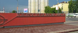
Sretensky District Museum of Local Lore 673540, Trans-Baikal Territory, Sretensky District, Sretensk, st. Embankment, 33
Architecture, sights
The main areas are stretched out in a narrow strip along the right bank of the Shilka. Some of the buildings are on the left high bank, near the railway. stations.
| Population by year (thousands of inhabitants) | |||||||
| 1897 | 1.4 | 1992 | 10.3 | 2007 | 7.9 | 2016 | 6.6 |
| 1926 | 8.6 | 1996 | 9.4 | 2008 | 7.9 | 2017 | 6.6 |
| 1931 | 12.3 | 1998 | 9.3 | 2010 | 7.9 | 2018 | 6.6 |
| 1939 | 13.5 | 2000 | 9.2 | 2011 | 6.9 | 2019 | 6.5 |
| 1959 | 15.1 | 2001 | 9.1 | 2012 | 6.7 | 2020 | 6.4 |
| 1970 | 13.8 | 2003 | 8.2 | 2013 | 6.7 | 2021 | 6.4 |
| 1979 | 13.4 | 2005 | 7.9 | 2014 | 6.6 | ||
| 1989 | 10.4 | 2006 | 7.9 | 2015 | 6.6 | ||
A beautiful city with ugly problems
Sretensk is one of the oldest cities in the Trans-Baikal Territory. This year it turns 330 years old. The city has a unique historical heritage; several kings visited it in their time. It turned out that in tsarist times the city was developed by merchants, during the Soviet times the communists built enterprises, also continuing to develop the city, but what they did with Sretensk now is impossible to look at without pain in the heart. The city certainly has a number of advantages, but we cannot remain silent about its shortcomings.
Dead roads
As soon as you turn off the federal highway towards Sretensk, a fierce thrash immediately begins. There are potholes, potholes and generally unknown things all around. People in the car are thrown to such an extent that they hit their heads on the ceiling. And you have to drive along this road for a couple of hours. It’s obvious that you won’t be able to sleep, and the main task on the journey is not to get a concussion.
Non-sports stadium
In the photo: Not a sports stadium at all
There is the Lokomotiv stadium in Sretensk, on which they spent as much as eight million rubles. Honestly? Walking around it, I didn’t see what could cost that kind of money. The football field is completely unsuitable for playing. It is simply uneven, there are some holes everywhere, and during the game such dust rises as if the matches are taking place in the desert. And in general, all these “sports facilities” are not suitable for sports in principle. At this stadium, instead of achievements, you can earn yourself health problems. But the icing on the cake is the podium and stage set against the backdrop of dilapidated street toilets. I don’t think such a masterpiece can be found anywhere else. What kind of harm did the Sretenets team do to the Lokomotiv designers? That’s a rhetorical question. The contractors must sincerely hate people if they did everything so badly.
Meanwhile, the mayor of the city, Sergei Tonkikh, explained that he took office after work on the stadium was completed. Now attempts are underway to fix everything
“We also see that there is a pedestal opposite the toilet, we have to cover it with a banner. Unfortunately, nothing can be done about it yet,” the mayor said.
As for the stadium itself, the head of Sretensk said that there are many deficiencies there and there is still enough work.
- Firstly, we will involve the previous head so that he can finish everything, and secondly, now we will deal with the “stuffing”. There will be volleyball, basketball and workout courts, as well as stands,” the city mayor said.
It's not so simple with a football field either. We will have to change it completely, replacing the current misunderstanding with artificial turf.
“They brought manure there and sowed it with grass, but it didn’t sprout, only quinoa remained.” We talked with regional specialists, this is the situation with grass everywhere, so we will have to lay down artificial turf,” Tonkikh continued.
Hemp paradise
In the photo: Sretensky paradise for drug addicts
Sretensk is definitely a paradise for Rastafarians and simply those who like to “blow”. I have never seen such thickets of “intoxicating grass” in my life. By the way, hemp grows even on the territory of the wonderful Sretensky Lokomotiv. They say, if it didn’t work out with sports, you can try something else, that’s what the local authorities probably thought. By the way, the mayor of the city, Sergei Tonkikh, said that the hemp will be mowed down in any case. The main thing is that the administration slows down to this before the lovers of cool sensations.
“Our plan is to cut it all off and destroy it.” Previously, we destroyed them with chemicals, but now we will mow them down,” said the head of Sretensk.
Fecal problem
Well, this is completely wild. All sewage accumulated by residents flows directly into the Shilka River. There people swim, get water, and fish. The unsanitary conditions are terrible. One wrong action, and you can earn yourself all sorts of unpleasant diseases. This applies not only to Sretenets. The Shilka flows into the Amur, so the local feces “travel” long distances. The same Sergei Tonkikh said that normal sewerage will cost more than 100 million rubles. Even with all its desire, the Sretensky administration will not be able to allocate such money, and there is absolutely no support from outside.
— Our sewage pumping stations (sewage pumping stations - ed.) cannot cope. The cars are old and break down. It happens that sewers overflow,” Tonkikh commented.
According to him, before perestroika it was planned to move the treatment facilities five kilometers from the city, but now there is simply no money for this.
- Yes, this problem exists, we are trying to solve it. This is difficult, again finances, because the price tag is over one hundred million,” concluded the mayor of Sretensk.
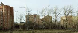
Children playing in ruins
In the photo: Collapsing buildings in the city
Ruins are the norm for any post-Soviet city. Where can we go from them? The problem is that there are an abundance of abandoned houses in Sretensk. It comes to the point that only two five-story buildings are inhabited in the microdistrict, and everything else is ruins. Naturally, children play there at risk to themselves. The main thing is that trouble does not happen, because if you remember yourself as a child, the instinct of self-preservation has not yet been properly developed, and curiosity is off the charts. So why aren’t they demolished or renovated, you ask? And where, again, will the money come from for this, and who will live there while the population is declining, which has also become the norm for the regions of Transbaikalia?
What could happen to Sretensk?
If the regional authorities do not pay attention to Sretensk, the city will die out in a couple of decades. I would like to repeat once again what I started with. The city is historical, there are a huge number of ancient buildings, and the nature there is a real competitor to the Scandinavian landscapes. Why do European countries take care of such cities and protect them, worrying about every stone on an ancient building, but in our country they don’t pay attention to everything? Sretensk could become a tourist city. Yes, it’s a pleasure to admire the views that exist there! However, we have what we have. The mayor of the city, Sergei Tonkikh, is trying to do at least something to improve the condition of the city. But what can the head of a small town do alone? By the way, in the next issue I will share with you about the advantages of Sretensk, which make me want to return there again.
Dmitry RYBAK
Photo by the author
Recommendations
Notes
- ^ a b c d f Register of administrative-territorial units and settlements of the Trans-Baikal Territory
- ^ a b
Federal State Statistics Service of Russia (2011).
“All-Russian Population Census 2010. Volume 1" [All-Russian Population Census 2010, vol. 1]. All-Russian Population Census 2010 [All-Russian Population Census 2010]
(in Russian). Federal State Statistics Service. - "26. The size of the permanent population of the Russian Federation by municipalities as of January 1, 2022.” Federal State Statistics Service. Retrieved January 23, 2022.
- ^ a b c
Law No. 317-ZZK - Law No. 316-ZZK
- Federal State Statistics Service. Federal Agency for Technological Regulation and Metrology. No. OK 033-2013 January 1, 2014 “All-Russian classifier of municipal territories. Code 76 640 101 ". (Federal State Statistics Service. Federal Agency for Technological Regulation and Metrology. No. OK 033-2013 January 1, 2014. Russian classification of municipal territories. Code 76 640 101.
). - "On the calculation of time." Official Internet portal of legal information
(in Russian). June 3, 2011. Retrieved January 19, 2022. - Post office. Information and computing center of OASU RPO. ( Post office
).
Search for postal facilities ( Search for postal facilities
) (in Russian) - Federal State Statistics Service of Russia (May 21, 2004). “The population of Russia, the constituent entities of the Russian Federation as part of federal districts, urban settlements, urban settlements, settlements, settlements is 3 thousand or more people” [Population of Russia, its federal districts, constituent entities of the federation, districts, urban settlements, rural settlements - administrative centers, rural settlements with a population of more than 3000 people] (XLS). All-Russian Population Census of 2002 [All-Russian Population Census of 2002]
(in Russian). - “All-Union Population Census of 1989. The current population of union and autonomous republics, autonomous regions and districts, territories, regions, urban settlements and rural district centers” [All-Union Population Census of 1989: current population of union and autonomous republics, autonomous regions and districts, territories, regions, districts, urban settlements and villages that are district administrative centers]. All-Union Population Census of 1989 [All-Union Population Census of 1989]
(in Russian).
Institute of Demography of the National Research University: Higher School of Economics [Institute of Demography of the National Research University: Higher School of Economics]. 1989 - via Demoscope weekly
. - "Sretensk, Russia." Climatebase.ru. Retrieved January 24, 2013.
- . Climatebase.ru https://climatebase.ru/station/30777/from2000/?lang=en. Retrieved January 24, 2013. Missing or Empty | title = (help)