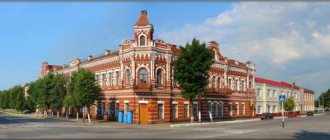
Tula region
Russia includes 30
urban settlements
, including[1][2][3]:
- 19 cities, among which stand out: 2 cities of regional subordination ( highlighted in orange
), which, within the framework of the organization of local self-government, form (are included in) urban districts. - 17 cities of district subordination, of which, within the framework of the organization of local self-government, 3 are included in city districts and 14 are included in the corresponding municipal districts.
Where is Tula?
The city of Tula is the administrative center of the Tula region, which is located in the north of the Central Russian Upland, on the banks of the Upa River.
Also on the territory of the city, three tributaries flow into the Upa River: Voronka, Tulitsa and Bezhka. The approximate population of the city of Tula is 483 thousand people. The total area of the city is 145 square kilometers. The nearest large cities: Kaluga, Shchekino, Ryazan, Moscow, Plavsk, Mikhailov, Aleksin, Serpukhov, Efremov, Novomoskovsk, Obninsk, Belev. The height of the central part of the city reaches 170 m above sea level. The vegetation that is planted in the city is artificial. The dominant trees are ash, oak, linden, birch, and poplar. Not far from Tula there are large forest areas. The climate in the city is temperate continental. The annual precipitation rate is 500-700 mm.
Tula is in the same time zone as Moscow, the offset relative to Coordinated Universal Time (UTC) is +3 (online time in Tula).
Population and cities of the Tula region
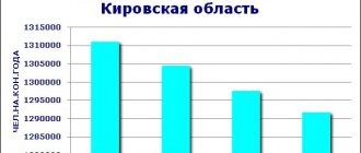
As of 2022, the region is home to 1.5 million people. Moreover, two thirds of its population are concentrated within the so-called Tula-Novomoskovsk agglomeration. About 75% of its residents live in the cities of the Tula region.
This is one of the most demographically unfavorable regions of Russia. It is the leader in natural population decline (6.8 people per 1000 inhabitants). There is an extremely low birth rate against the background of increased mortality and low life expectancy. In addition, young people are rapidly leaving the region, attracted by the proximity of Moscow.
The very first settlements on the territory of the modern Tula region arose 12,000 years ago. The oldest city in the region is Tula. It was founded in the 12th century (according to other sources, in the 14th century). At the end of the 17th century, this region turned into an important center of blacksmithing in Russia. Active industrial development of the region begins, which contributes to the creation of new cities and towns.
Today, there are 19 cities. But only two of them have more than 100 thousand inhabitants. All cities of the Tula region (in order of decreasing population) are listed below:
- Tula.
- Novomoskovsk.
- Donskoy.
- Aleksin.
- Shchekino.
- Nodal.
- Efremov.
- Bogoroditsk.
- Kimovsk.
- Kireevsk.
- Suvorov.
- Plavsk.
- Yasnogorsk
- Venev.
- Belev.
- Bolokhovo.
- Sticky.
- Soviet
- Chekalin.
Tula Airport
In Tula there is Klokovo Airport, a military airfield located on the northern outskirts of the city. During the period from 1959 to 1990, this airport had the status of a joint airfield. The distance from the city center to the airport is 7.5 km. Airport operating hours are from 10:00 to 18:00.
Currently the facility is operating in closed mode. The airport only accepts military helicopters and small aircraft. To enter the territory of the Klokovo airfield, you must obtain a special pass. Despite this, passengers can use the services of the airport: rent aircraft - a high-speed jet NG-5 and a small helicopter R-44.
Cities[ | ]
| № | Name | district/city of regional subordination[5] | municipal district / urban district[6] | population (persons) | founding/first mention | city status | coat of arms | former names |
| 1 | Aleksin | Aleksinsky district | Aleksin city, GO | ↘57 102[4] | 1348 | 1777 | ||
| 2 | Belev | Belevsky district | Belevsky municipal district | ↘12 484[4] | 1147 | 1147 | ||
| 3 | Bogoroditsk | Bogoroditsky district | Bogoroditsky municipal district | ↘30 199[4] | 1663 | 1777 | ||
| 4 | Bolokhovo | Kireyevsky district | Kireyevsky municipal district | ↘8738[4] | 16th century | 1943 | ||
| 5 | Venev | Venevsky district | Venevsky municipal district | ↘13 691[4] | 1371 | 1777 | ||
| 6 | Donskoy | Donskoy city | Donskoy city, GO | ↘61 477[4] | 1773 | 1939 | until 1929 - a village at the mine named after A. I. Rykov | |
| 7 | Efremov | Efremovsky district | Efremov city, GO | ↘33 965[4] | 1637 | 1777 | ||
| 8 | Kimovsk | Kimovsky district | Kimovsky municipal district | ↘25 142[4] | 17th century | 1952 | until 1948 - Mikhailovsky | |
| 9 | Kireevsk | Kireyevsky district | Kireyevsky municipal district | ↘26 277[4] | 1762 | 1956 | Kireevka | |
| 10 | Lipki | Kireyevsky district | Kireyevsky municipal district | ↘8084[4] | 17th century | 1955 | ||
| 11 | Novomoskovsk | Novomoskovsky district | Novomoskovsk city, GO | ↘121 674[4] | 1765 | 1930 | until 1933 - Bobriki until 1961 - Stalinogorsk | |
| 12 | Plavsk | Plavsky district | Plavsky municipal district | ↘15 563[4] | 1563 | 1949 | until 1926 - Sergievskoe | |
| 13 | Sovetsk | Shchekinsky district | Shchekinsky municipal district | ↘7246[4] | 1949 | 1954 | ||
| 14 | Suvorov | Suvorovsky district | Suvorovsky municipal district | ↘17 006[4] | 1949 | 1954 | until 1954 - Suvorovsky | |
| 15 | Tula | Tula city | Tula city, GO | ↘467 955[4] | 1146 | 1146 | ||
| 16 | Nodal | Uzlovsky district | Uzlovsky municipal district | ↘49 155[4] | 1873 | 1938 | until 1877 - Khrushchevskaya | |
| 17 | Chekalin | Suvorovsky district | Suvorovsky municipal district | ↗866[4] | 1565 | 1565 | until 1944 - Likhvin | |
| 18 | Shchyokino | Shchekinsky district | Shchekinsky municipal district | ↘56 263[4] | 1870 | 1938 | ||
| 19 | Yasnogorsk | Yasnogorsk district | Yasnogorsk municipal district | ↘14 984[4] | 1578 | 1958 | until 1965 - Laptevo |
Settlements that have lost their city status[ | ]
Preserved, but lost city status:
- Dedilov - now the village of Dedilovo. Known as the city of Dedoslavl since the 12th century; in 1238 destroyed by the Mongol-Tatars; again a city from 1553 to 1777.
- Epifan is now a village. The city from 1777 to 1926.
- Krapivna is now a village. City until February 22, 1926.
- Odoev - now the town. The city from the 14th century to 1926.
- Chern is now a town. City until February 22, 1926.
Joined other cities:
- Severo-Zadonsk has been a city since 1950, and became part of the city of Donskoy in 2005.
- Sokolniki has been a city since 1958 and became part of Novomoskovsk in 2008.
Train Station
In Tula there is the Moskovsky railway station - the passenger terminal of the Tula I-Kurskaya junction station. It is the largest railway station in the city. The station is located at st. Puteyskaya, 4, free car parking is available on site. The very first railway station building was built in 1867. The main station building houses a cafe, a medical center, shops, a spacious waiting room and storage rooms.
The most popular long-distance train destinations: Moscow, Orel, St. Petersburg, Vladikavkaz, Belgorod, Krivoy Rog, Serpukhov, Kursk, Adler, Anapa, Stary Oskol, Baku, Perm, Kharkov, Dnepr. In the summer, trains pass through the railway station in the following directions: Sochi, Rostov-on-Don, Yeisk, Novorossiysk.
Also in the city of Tula there is the Tula-II Kurskaya railway station. It is used for storing decommissioned freight cars.
Novomoskovsk and its "Nitrogen"
The city of Novomoskovsk, Tula region, is one of the cores of the Tula-Novomoskovsk agglomeration already mentioned in this article. It is home to about 125 thousand people. Novomoskovsk grew out of the Bobriki estate, which once belonged to the illegitimate descendants of Count Orlov and Empress Catherine. It became a city only in 1930.
In modern Novomoskovsk there are over a hundred different enterprises. The most important of them is Azot, the largest chemical plant in the country and one of the leaders in the production of ammonia and nitrogen fertilizers in the world. It is interesting to note that during the Second World War, the German command classified the city of Novomoskovsk as one of the most important industrial bases of the USSR. In this regard, all city enterprises, especially the chemical plant, were subject to heavy bombing.
However, Novomoskovsk Azot survived and was reborn. In 2015, the net profit of this enterprise amounted to 17.4 billion rubles.
Bus stations of Tula
The bus station in Tula is located at Lenin Avenue, 94, next to Victory Square. The main building of the bus station is located next to the higher educational institution of Tula State University. The station is open every day around the clock. You can get to the bus station by public transport, which goes to the Stanislavsky or Ploshchad Pobedy stop. The bus station building houses a cozy cafe, a spacious waiting room, and luggage storage facilities. There are also several ticket offices and a help desk.
The most popular routes of regular buses at the Tula bus station: Tambov, Arsenyevo, Arkhangelskoye, Voronezh, Dubna, Volov, Gorlovka, Kaluga, Kireevsk, Kursk, Lipetsk, Moscow, Novomoskovsk, Orel, Plavsk, Smolensk, Teploye, Yasnogorsk, Chern.
Urban settlements
| Name | District/Urban district | Population | Founding/First mention | PGT status | Coat of arms | Former names | Coordinates |
| Arsenyevo | Arsenyevsky district | ↘4704[2] | 1897 | 1966 | 53°44′24″ n. w. 36°39′15″ E. d. | ||
| Volovo | Volovsky district | ↗3537[2] | XVIII century | 1970 | 53°33′20″ n. w. 38°01′20″ E. d. | ||
| Dubna | Dubensky district | ↘5779[2] | 1740 | 1929 | 54°09′23″ n. w. 36°57′27″ E. d. | ||
| Zaoksky | Zaoksky district | ↘6548[2] | 1935 | 1970 | 54°44′06″ n. w. 37°24′02″ E. d. | ||
| Kurkino | Kurkinsky district | ↘4974[2] | 1595 | 1968 | 53°26′12″ n. w. 38°40′11″ E. d. | ||
| Novogurovsky | Aleksinsky district/Novogurovsky district | ↗3460[2] | 1946 | 1966 | 54°28′00″ n. w. 37°20′00″ E. d. | ||
| Odoev | Odoevsky district | ↘5463[2] | 1380 | 1959 | 53°56′32″ n. w. 36°41′59″ E. d. | ||
| Pervomaisky | Shchekinsky district | ↘9315[2] | 1946 | 1950 | Gas village | 54°02′15″ n. w. 37°30′18″ E. d. | |
| Glorious | Arsenyevsky district/GO Slavny | ↘1864[2] | 1961 | 2008 | Tula-50 | 53°32′44″ n. w. 36°28′30″ E. d. | |
| Warm | Teplo-Ogarevsky district | ↘4881[2] | 19th century | 1971 | 53°36′39″ n. w. 37°35′39″ E. d. | ||
| Black | Chernsky district | ↘6348[2] | 1566 | 1971 | 53°27′00″ n. w. 36°54′36″ E. d. |
Automobile highways
Three federal highways pass through Tula:
- M2 "Crimea" is a federal highway that originates in Moscow and passes through Orel, Kursk, Tula, and Belgorod. The final destination of the road is the state border with Ukraine. It is part of the European route E105. The total length of the route is 700 km.
- P132 is a federal highway with a total length of 291 km. The highway passes through Kaluga, Ryazan, Mikhailov and Tula. Road surface: asphalt.
- E105 is a European route that starts in the Norwegian city of Kirkenes and passes through the following Russian cities: Murmansk, Orel, Tver, Veliky Novgorod, St. Petersburg, Belgorod, Moscow. The total length of the highway is 3,770 km.
Tula region on the map
You can find the Tula region on the map and get directions using your navigator using the coordinates (53.888064, 37.575693). In the northeast it neighbors the Moscow region, in the east - with the Ryazan region, in the south - with the Lipetsk region, in the southwest - with the Oryol region. To the north is the Kaluga region.
What is Tula known for?
First of all, Tula is known for its gingerbread and the production of samovars. Also in the Tula province, the famous classic of Russian literature Leo Tolstoy was born. In the former estate of the classic - on the estate of his mother "Yasnaya Polyana" - there is currently an estate museum.
The first state-owned arms factory was opened in Tula in 1712 by decree of Peter I. The city has a famous samovar museum, which opened in 1990 and is considered the most popular destination among tourists from all over the world. In the gingerbread museum, city guests can find the most unusual and popular samples of gingerbread made by Tula confectioners for various great events.
The city of Donskoy and its shoes
Donskoy is located just ten kilometers south of Novomoskovsk. This small city (60 thousand inhabitants) was once proudly called the “mining capital of the region.” Brown coal was actively mined here. By the 70s, coal had run out, and the city of Donskoy quickly switched to other types of activities. In particular, shoe and leather goods factories appeared here, the products of which are known and appreciated far beyond the city limits.
Today, a fifth of the economically active population of Donskoy is employed in small businesses, which, by the way, provides 13% of income for the local budget. Thanks to small and medium-sized businesses, the city boasts the lowest unemployment rate in the region.