Kimry on the map of Russia: geography, nature and climate
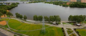
Kimry is located east of the regional center, 100 km from the capital of Russia. The settlement was built where the Kimrka River flows into the Volga . The relief features within the city are due to its location in the Upper Volga lowland . The height of the area above sea level is 100-130 meters. Swampy, podzolic and floodplain soils predominate.
Kimry is a typical city with a temperate continental climate. Summers in these parts are cool and humid, winters are quite long and cool. In July, the warmest month of the year, the average air temperature is around +18.7 °C; in February the air cools down to −7.6 °C.
Looking at the map of Kimry from a satellite, one cannot help but notice that the city is surrounded by forests. Both coniferous and deciduous trees grow here. Hares, foxes and raccoon dogs are found in the forests. Beavers live in rivers.
About the city of Kimry
Kimry is a city of regional subordination, the center of the Kimry district. The city is located in the southeast of the Tver region on the largest and most abundant river in all of Europe - the Volga River (Uglich Reservoir) near the mouth of the Kimrka River.
Until the beginning of the 20th century, it was called Kimra, due to its location at the confluence of the Kimera River with the Volga. After the emergence of the village, it was renamed first to Kimerka, and then to Kimrka. V.N. Tatishchev assumed the formation of the name from the ethnonym Chimera (Cimmerians). More likely a later origin from a Finnish or Baltic base. In one case, the base “kim-” is associated with the Finnish kiima “tokovishte”, in the second case with the Lithuanian “kymzryne - a swamp with a lot of rotten stumps”. At the turn of the 20th century, the name of the city received a plural form.
You can find out more detailed information both about the geographical location of Kimry and about the origin of the city’s name in the “History Sketches” section.
Routes on the map of Kimry. Transport infrastructure
You can get to the city of Kimry both by land and by water.
Railway transport
On the right bank of the Volga, in the Savelovo area, there is a railway station in the city of Kimry (Tupoleva St., 1, Kimry). Trains running on the Moscow-Uglich route stop here. You can also travel from the capital to Savelovo by train.
Automobile transport
The highway 28K-0713 (Dubna-Kimry-Goritsy) and the highway 28K-0733 pass through Kimry, which can be reached through the city of Taldom, following from Moscow along the A-108 , then turning at Zhestylev onto the P122 .
River transport
Kimry is one of the stops on the routes of cruise ships plying along the Volga .
Urban transport
You can get to any part of the city by bus.
1.5 km from the city, near the village of Kletino, there is the Borki sports airfield, offering familiarization flights over Kimry.
History of the city of Kimry
The first time, then still the village of Kimry, was mentioned in the charter of Ivan the Terrible dated 1546. You can get acquainted in more detail with the contents of the first official mention of Kimry in one of the articles “Essays”. By that time it was already a fairly large trading village in the Korchevsky district of the Tver province, its inhabitants were famous as skilled artisans.
Back in 1677, the palace village was under the jurisdiction of the Grand Palace, then it belonged to the Saltykovs and Skavronskys. In 1847, the residents of this village were bought from Countess Yu.P. Samoilova to freedom with the land. On our website you can find out more detailed information about the owners of the village of Kimry.
Even Empress Catherine II favored Kimry with her attention. In her diary from 1767 you can find the following entry: “Hour by hour the banks of the Volga are getting better. Yesterday we passed Kimru, which from a distance is not inferior to Peterhof, but up close it’s not the same.” We propose to learn in more detail about the empress’s participation in the development of the village and the province as a whole in the article “Kimry - the village.”
In the 18th century, the village became the center of the shoemaking industry. Kimry craftsmen receive government orders to sew shoes for the army. By the beginning of the 20th century, the village already exceeded many county towns in terms of the number of inhabitants (10 thousand), and wealthy Kimryaks even built houses in the “modern” style. Those who are interested can read the architectural characteristics of the city on our website.
The change in the status of Kimry had been brewing for a long time, but Kimry received the right to be called a city only in June 1917. Later, the ancient village of Savelovo, where the railway station of the same name is located, belongs to the Oktyabrskaya Railway, connecting the cities of Moscow and St. Petersburg, also became part of the city. In 1926, a machine-building plant and a workers' village were built in Savelovo.
The Moscow-Savelovo railway line was put into operation in 1900. Traffic to Kalyazin was opened only in 1919. Since 1920, regular communication with Rybinsk and Vesyegonsk began, and in the mid-30s, traffic was opened to Uglich. Finally, the construction of the Ovinishche - Mga line, completed in the 50s, made the Savelovskaya branch a reserve backup for the Moscow-Leningrad railway. In 1978, the Verbilki-Savelovo section was electrified, which made communication with Moscow by electric trains possible.
For a long time, the Savelovo station was used for transshipment of cargo onto flat-boats, where they were transported along the Volga to Rybinsk and then transferred to barges. Since 1940, after the implementation of the “Big Volga” master plan as a result of the construction of the Ivankovsky, Uglich and Rybinsk hydroelectric complexes, the Volga became navigable to Tver and the need for transporting large cargo along the Savelovskaya branch disappeared.
Sights of the city of Kimry
- You can find out more about the history of the city by visiting the Kimry Museum of Local Lore .
- The monument to the Kimry shoemaker reminds of the past of the settlement .
- In honor of the soldiers who died in battles with the Nazis during the Second World War, a bayonet-shaped obelisk .
- The exhibitions of the District House of Crafts and Folklore will tell about the culture and life of the peasants who lived in these places several centuries ago .
- Noteworthy examples of religious architecture in the city of Kimry are the Transfiguration Cathedral and the Church of Our Lady of Jerusalem .
- Cultural leisure for residents and guests of the city is provided by the Kimry Drama Theater .
Kimry today
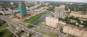
The city of Kimry is located on both banks of the Volga River. It owes both its origin and its further development to it. Currently, there are transit and intra-city berths in Kimry. On the left bank, the city center is now located. Many ancient buildings have been preserved here, most of which are architectural monuments. The Savelovo microdistrict, located on the right bank of the Volga, is predominantly built up with more modern houses.
The banks are connected by a large bridge across the Volga, built in the early 80s and restored in the 21st century. Until this time, the crossing was carried out using passenger and cargo ferries. There are roads leaving the city in three directions. The ancient Ilyinskaya road through Goritsy leads to Tver and Kashin. You can get to the capital along the Moscow road through Dubna and Dmitrov. The Taldom road leads to Bely Gorodok, Taldom, and Kalyazin. You can also get to Dubna and further along the local road leaving from Savelovo station.
The city of Kimry is surrounded by both large and small settlements. There is a regular bus service between the city and most of them. Kimry is connected by bus routes to the cities of Tver and Moscow, the distance to which is 135 and 150 km, respectively. In addition to buses, Kimry is also connected to Moscow by the Savelovo railway station. You can find out the schedule of buses and electric trains in the main section of the site.
Long-distance communication is provided with Moscow and Rybinsk. Suburban communication by electric trains is carried out with Taldom, Dmitrov, and Moscow. Suburban service has been organized with Kalyazin, Uglich, Kashin, and Sonkovo by “working” trains with diesel traction.
Kimry is a port city on the Volga, and 15 km downstream in Bely Gorodok there is a large ship repair enterprise.
The area of the city of Kimry is approximately 43.6 square kilometers, of which 4.4 square kilometers are occupied by household plots of citizens, and 3.4 by collective gardens.
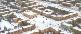
Today, according to the 2010 All-Russian Population Census, 49 thousand people live in the city.
Kimry is the largest industrial center in the region. The city's industry is represented by various sectors. The main ones are mechanical engineering (machine tool building, aircraft factories of the military-industrial complex), light industry (clothing, shoe industry and furniture production) and food industry. The region's economy employs more than 26 thousand people.
Meat and dairy cattle breeding and pig breeding are developed in the Kimry region. Potatoes are grown.
The city has a mechanical and technological college, a medical school, and a branch of the university.
Main streets of the city of Kimry
On the map of Kimry with streets, the main arteries of the city are clearly visible:
- st. Uritsky
- st. Ordzhonikidze
- st. Volodarsky
- st. Vagzhanova
- st. Karl Liebknecht
- st. 50 years of the Komsomol
- st. Chapaeva
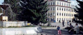
At the entrance to Kimry, Ilyinskoye Highway turns into Uritsky Street , which stretches to the Volga River. Following Uritsky Street, you can see the city bus station, the Transfiguration Cathedral, and the Kimry District Administration building.
Ordzhonikidze Street runs along the left bank of the Volga. Near the street there are South Square, Molodezhny, and the Maltsevsky Bor green area.
Volodarsky Street is also laid along the left bank of the Volga . While walking along it you can see Theater Square and the Kimry Drama and Comedy Theater, the city park and the Zvezda stadium.
Vagzhanova Street crosses Uritsky Street and runs perpendicular to it. Near Vagzhanova Street there is a city hospital and a cultural center of the factory named after. Gorky.
Karl Liebknecht Street runs parallel to the Kimrka River. There are several green areas along this street.
50 Let VLKSM Street runs between the Volga and the railroad tracks on the right bank of the river. Not far from the street there is a monument to the residents of Kimra who died a brave death during the Second World War, a monument to Afghan soldiers, and a monument to military personnel who died in the North Caucasus.
On the right bank of the Volga there is Chapaeva Street , next to which the hospital and the 40 Let Oktyabrya Palace of Culture are located.
History of the city of Kimry
Kimry is a city of regional subordination, the center of the Kimry district. The city is located in the southeast of the Tver region on the largest and most abundant river in all of Europe - the Volga River (Uglich Reservoir) near the mouth of the Kimrka River.
Until the beginning of the 20th century, it was called Kimra, due to its location at the confluence of the Kimera River with the Volga. After the emergence of the village, it was renamed first to Kimerka, and then to Kimrka. V.N. Tatishchev assumed the formation of the name from the ethnonym Chimera (Cimmerians). More likely a later origin from a Finnish or Baltic base. In one case, the base “kim-” is associated with the Finnish kiima “tokovishte”, in the second case with the Lithuanian “kymzryne - a swamp with a lot of rotten stumps”. At the turn of the 20th century, the name of the city received a plural form.
You can find out more detailed information both about the geographical location of Kimry and about the origin of the city’s name in the “Essays” section.
History of the city of Kimry
The first time, then still the village of Kimry, was mentioned in the charter of Ivan the Terrible dated 1546. You can get acquainted in more detail with the contents of the first official mention of Kimry in one of the articles “Essays”. By that time it was already a fairly large trading village in the Korchevsky district of the Tver province, its inhabitants were famous as skilled artisans.
Back in 1677, the palace village was under the jurisdiction of the Grand Palace, then it belonged to the Saltykovs and Skavronskys. In 1847, the residents of this village were bought from Countess Yu.P. Samoilova to freedom with the land. On our website you can find out more detailed information about the owners of the village of Kimry.
Even Empress Catherine II favored Kimry with her attention. In her diary from 1767 you can find the following entry: “Hour by hour the banks of the Volga are getting better. Yesterday we passed Kimru, which from a distance is not inferior to Peterhof, but up close it’s not the same.” We propose to learn in more detail about the empress’s participation in the development of the village and the province as a whole in the article “Kimry - the village.”
In the 18th century, the village became the center of the shoemaking industry. Kimry craftsmen receive government orders to sew shoes for the army. By the beginning of the 20th century, the village already exceeded many county towns in terms of the number of inhabitants (10 thousand), and wealthy Kimryaks even built houses in the “modern” style. Those who are interested can read the architectural characteristics of the city on our website.
The change in the status of Kimry had been brewing for a long time, but Kimry received the right to be called a city only in June 1917. Later, the ancient village of Savelovo, where the railway station of the same name is located, belongs to the Oktyabrskaya Railway, connecting the cities of Moscow and St. Petersburg, also became part of the city. In 1926, a machine-building plant and a workers' village were built in Savelovo.
The Moscow-Savelovo railway line was put into operation in 1900. Traffic to Kalyazin was opened only in 1919. Since 1920, regular communication with Rybinsk and Vesyegonsk began, and in the mid-30s, traffic was opened to Uglich. Finally, the construction of the Ovinishche - Mga line, completed in the 50s, made the Savelovskaya branch a reserve backup for the Moscow-Leningrad railway. In 1978, the Verbilki-Savelovo section was electrified, which made communication with Moscow by electric trains possible.
For a long time, the Savelovo station was used for transshipment of cargo onto flat-boats, where they were transported along the Volga to Rybinsk and then transferred to barges. Since 1940, after the implementation of the “Big Volga” master plan as a result of the construction of the Ivankovsky, Uglich and Rybinsk hydroelectric complexes, the Volga became navigable to Tver and the need for transporting large cargo along the Savelovskaya branch disappeared.
Kimry today
The city of Kimry is located on both banks of the Volga River. It owes both its origin and its further development to it. Currently, there are transit and intra-city berths in Kimry. On the left bank, the city center is now located. Many ancient buildings have been preserved here, most of which are architectural monuments. The Savelovo microdistrict, located on the right bank of the Volga, is predominantly built up with more modern houses.
The banks are connected by a large bridge across the Volga, built in the early 80s and restored in the 21st century. Until this time, the crossing was carried out using passenger and cargo ferries. There are roads leaving the city in three directions. The ancient Ilyinskaya road through Goritsy leads to Tver and Kashin. You can get to the capital along the Moscow road through Dubna and Dmitrov. The Taldom road leads to Bely Gorodok, Taldom, and Kalyazin. You can also get to Dubna and further along the local road leaving from Savelovo station.
The city of Kimry is surrounded by both large and small settlements. There is a regular bus service between the city and most of them. Kimry is connected by bus routes to the cities of Tver and Moscow, the distance to which is 135 and 150 km, respectively. In addition to buses, Kimry is also connected to Moscow by the Savelovo railway station. You can find out the schedule of buses and electric trains in the main section of the site.
Long-distance communication is provided with Moscow and Rybinsk. Suburban communication by electric trains is carried out with Taldom, Dmitrov, and Moscow. Suburban service has been organized with Kalyazin, Uglich, Kashin, and Sonkovo by “working” trains with diesel traction.
Kimry is a port city on the Volga, and 15 km downstream in Bely Gorodok there is a large ship repair enterprise.
The area of the city of Kimry is approximately 43.6 square kilometers, of which 4.4 square kilometers are occupied by household plots of citizens, and 3.4 by collective gardens.
Today, according to the 2010 All-Russian Population Census, 49 thousand people live in the city.
Kimry is the largest industrial center in the region. The city's industry is represented by various sectors. The main ones are mechanical engineering (machine tool building, aircraft factories of the military-industrial complex), light industry (clothing, shoe industry and furniture production) and food industry. The region's economy employs more than 26 thousand people.
Meat and dairy cattle breeding and pig breeding are developed in the Kimry region. Potatoes are grown.
The city has a mechanical and technological college, a medical school, and a branch of the university.
Culture
On the high bank of the Volga, at the confluence of the Kimrka, there used to be the Intercession and St. Nicholas Cathedrals with a bell tower, which formed the then appearance of the city center. They were blown up in the 30s. Approximately in their place now stands the building of the city drama theater, which has been operating since 1942. Kimry also has its own crafts center and several newspapers are published.
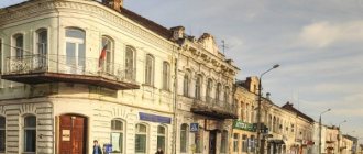
In the center of the city, attention is drawn to the old shopping arcades, a bit reminiscent of the Moscow GUM in miniature. The building is empty and falling into disrepair.
If you walk from it along the street away from the Volga, then after a couple of hundred meters on the left on the corner there will be a local history museum. It was founded in 1918. The only shoe museum in Russia, the exhibition presents a large number of examples of Kimry shoes from the 18th - 20th centuries. Unique collections of sculptural works by local sculptor I.M. Abalyaev, reflecting the life and way of life of the Kimryaks and photographs by the photo chronicler of Kimr L.V. Shokin. There is a memorial hall to A.N. Tupolev, who was born in this city. In addition to the aircraft designer, the city is associated with biographies of such people as the writer A.A. Fadeev, poet O.E. Mandelstam, scientist M.M. Bakhtin. The artist A.K. Savrasov and the playwright A.N. Ostrovsky lived here for some time.
The current Church of the Transfiguration. The inside has been preserved quite well, apparently not from those that were recently handed over to believers.
On the spit of the Volga and Kimerka stands the second of the surviving churches - Voznesenskaya (early 19th century). It is being restored from a dilapidated state and has been in operation for several years.
Among the architecture of the city, private houses with turrets in the Art Nouveau style (apparently, the edge of the 19th-20th centuries) attract attention.
It should be noted that if it were not for the destruction of the center of Kimry during the years of Soviet power, its value within the framework of the “Golden Ring” would have been much higher. Currently, the appearance of the city is still affected by poverty and desolation. And in recent years, they have gained notoriety as “the small capital of the Russian drug business.”