A trip along the middle Volga will definitely lead to the small town of Zhigulevsk, located not far from Togliatti. Here you can make a stop to get acquainted with the history of the Russian outback, find out who barge haulers are, and feel for yourself how mysterious Russian nature is. There are quite good hotels in the city that provide traditional services to guests. If you want a secluded environment, you should book an apartment. Getting to know the sights will take one or two days. It is recommended to start with natural surroundings.
Main streets of Zhigulevsk
On the map of Zhigulevsk you can see the main streets with house numbers and nearby objects:
- st. Novo-Samarskaya runs through the entire city next to Mount Lipovaya Griva;
- st. Komsomolskaya crosses the street. Nikitinskaya. Nearby – Mogutovaya Mountain, the recreation park named after the 40th anniversary of the Komsomol, the Crystal stadium;
- st. Vokzalnaya is located on the outskirts of the city, not far from Samarskaya Luka. Nearby is a railway station;
- st. Tkacheva passes along the border of the Zhigulevsky cemetery.
Tourist community
Bakhilovo. Witch Lake
The first attraction of the Zhigulevsky Nature Reserve on the way is Witch Lake. Directly in front of the village of Bakhilovo, near the sign, there is a right turn onto a dirt road. Along it you are less than 1 km away. get to the Witch Lake
Bakhilovo - turn right
The attraction of the village of Bakhilovo is the Witch Lake, or rather the path running along the lake called the Witch Lake, turned into a fairy-tale place with mythological characters - the devil, the goblin and all other “evil spirits”.
Witch Lake
The trail introduces you to the history of the emergence of the village of Bakhilovo, the tales and legends of the Mordovians - Moksha, the founders of the village. The village was founded by the Golden Horde at the end of the 13th - beginning of the 14th centuries. as transit points on the Volga caravan route. The settlement of the Mordvins and other conquered peoples was forced. The local population treats their culture and traditions with care.
Photo. The beginning of the trail.
Traditions and legends are associated with this place that since ancient times there were many sorcerers and witches among the local residents. They treated, relieved suffering people from the evil eye and other misfortunes, and could bring damage to those they disliked. The witch preparing her potion is the first to greet the guests.
Photo. Mistress of the lake.
There is also an old oak tree that wraps around a young linden tree. It is considered to be the tree of desires and love. Anyone who wants to find or keep the love of their life can tie a talisman ribbon here and make a wish.
Photo. Wish tree
The territory occupies no more than 150 meters, but with what love, warmth and care this “fairy-tale” place is organized. There are crucian carp in the lake, and not small ones at that, and you want to go to the toilet not only to relieve yourself, but just to take a look.
Photo. Hut - toilet.
Bakhilova glade. Count's spring
Further 5.5 km. way to the next stop on our route - the village of Bakhilova Polyana. The village appeared around the 17th century as a place of temporary housing for hunters, limestone miners, and beekeepers. These places are famous for their beauty. To the right of the asphalt serpentine mountain road on the way to Bakhilova Glade are the almost vertical rocky slopes of the Malaya Bakhilova and Meshanaya mountains. On the left is a picturesque ravine overgrown with forest. Here you can still see relict vegetation. There is no place on the Volga more beautiful than Zhiguli, and there is no valley in Zhiguli more picturesque than Bakhilova Polyana. Here, several ravines converge in a fan-shape, separated by ridges - sometimes gentle, sometimes steep, with rocky rocks, sometimes overgrown with forest.
Photo. Bakhilova Polyana, view from the road
The attraction of the village, in addition to the administration of the reserve named after. Sprygina, is the Grafsky spring. You can get to it along the main road of the village, past the administration of the reserve, and then turn right, towards the Volga.
Photo. Grafsky spring
It is the only powerful source on the banks of the Volga in the interval from Morkvashi to Shiryaevo. The spring has historical significance - it has been known since the time of the first settlers on Samarskaya Luka. The name “Grafsky” is associated with the Orlov-Davydov family, owners of most of the territory of Samarskaya Luka and who had a logging point, a board-rail road and a pier within the modern village of Bakhilova Polyana. The water coming out of the spring flows into the Volga and does not freeze even in the most severe frosts. Waterfowl winter here.
Photo. Healing spring
The bank of the Volga is sandy, and local residents happily spend hot summer days in the cool waters of the river.
Photo. Beach in Bakhilova Polyana
Ash. Mount Strelnaya
After swimming, resting and taking some spring water, you can hit the road. Our goal is Mount Strelnaya. The next stop is the village of Zolnoye. 11 km. There is an asphalt serpentine road to the village, with a magnificent view of the Zhiguli Mountains. In the 10th century, one of the Persian writers called these mountains Pechenezhsky, and in the Kazan Chronicle of the 1560s they are mentioned as Maiden Mountains. At the same time, modern historians believe that the name of these mountains comes from the Turkic word dzhiguli, which means “harnessed” and is explained by the fact that barge haulers lived in this place. According to another version, the modern name of the Zhiguli Mountains comes from the name of the village of Zhiguli, which, in turn, was named after the nickname of one of the first settlers, Semka Zhiguli.
Zhiguli Mountains
The only “public” entrance to the Zhigulevsky Nature Reserve is in the village of Zolnoye, at the beginning of a winding road running along the bottom of the Starootvazhnensky ravine. There is only one permitted route here – Mount Strelnaya. From the “Strelnaya Gora” sign, drive 400 meters to the checkpoint, register, pay 500 rubles. from a car and 12 km. drive along the gravel road to the parking lot. Then the path begins on foot (700 meters) to the observation deck of Mount Strelnaya.
Photo. Birch Alley. The beginning of the way.
Photo. Road to the Strelnaya observation deck
The panorama opening from the mountain has become a kind of icon of the Zhiguli, if not the entire Samara region. According to legend, in the 16th-17th centuries, Mount Strelnaya, as well as some other mountain peaks, were used as observation points by gangs of fugitive peasants, who are known in history as the “Zhiguli freemen”. This was the time when serfs who fled from unbearable oppression to Samara Luka created a kind of “Volga republic” here, living according to the laws of the “wild field”. They robbed the Nogai uluses located in the Volga region, as well as merchant ships passing along the Volga
Photo. View from the mountain to Seredysh (Bakhilovsky) island.
From the highest point of the mountain there is a narrow rocky ridge - the “Devil's Bridge”. According to legend, during the times of the Zhiguli freemen, robbers, blindfolded and drinking a glass, walked across the Devil's Bridge, showing off their prowess.
Photo. Devil's Bridge
But the highest point of Zhiguli is Mount Observer (height 381 meters). It rises above the village of Zolnoye and is easily recognizable thanks to the repeater mast installed on it. Here from 1955 to 1987. Zolny Gas and Gasoline Plant was operating. There is only one pipe left from the plant. From the top of the dome descends the Golovnoy ravine, so named, apparently because well No. 1 was drilled here, which produced the first oil from the Zolnenskoye field on the last day of 1943. Oil production continues to this day. We see many oil pumping stations along the mountain gorges.
Photo. Oil production "rocking chair"
The road to Mount Observer is closed, as indicated by signs on the way to Mount Strelnaya.
Photo. Road to Mount Observer
And from the side of the Head Gully the road is closed.
Photo. Barrier
Sunny glade
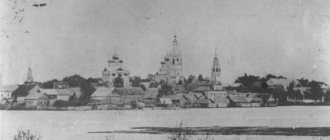
Heading to the campsite in Solnechnaya Polyana, entering the village, you will certainly see the Church of St. Nicholas. It is simply impossible not to stop and admire this beauty.
Photo. Church in Solnechnaya Polyana
And at the end of such a long and educational journey, of course, dinner by the fire on the banks of the Volga. Both in the village of Solnechnaya Polyana and in the village of Bogatyr there are cozy pebble beaches where you can pitch a tent. You can civilly stay in a tourist camping camp, which is located in Solnechnaya Polyana, almost on the banks of the Volga with an excellent beach.
Photo. Barbecue of savage tourists
Talking about Solnechnaya Polyana, it should be noted that from this village you can officially get on the path that leads to the Stone Bowl tract, to the holy spring of St. Nicholas the Wonderworker. You buy a ticket from the administration and get on the trail. This path to the Chalice is longer than through the village. Shiryaevo, more difficult, but also more interesting. But that's a different story for the route, which can be found here.
Happy travels to you.
History of the city of Zhigulevsk
- 1647 - the first mention of the village of Morkvashi, on the site of which the modern city is located.
- In 1840, Count Orlov-Davydov V.P. founded the village of Otvazhnoe, the territory of which today belongs to Zhigulevsk.
- In 1937, an oil well was found in the valley of the Zhiguli Mountains. For oil workers developing new wells, the working village of Zhigulevsk was built.
- 1950 - the beginning of construction of the Volzhskaya Hydroelectric Power Station named after V.I. Lenin. Thousands of specialists who came to the all-Union construction site settle in the workers' village.
- In 1952, the village was renamed the city of regional subordination Zhigulevsk.
- In 1957, the construction of the Volzhskaya hydroelectric power station was completed, which today is called Zhigulevskaya.
- In 2006, Zhigulevsk received the status of an urban district.
Routes on the map of Zhigulevsk. Transport infrastructure
Zhigulevsk is crossed by the M5 highway - a federal highway . The distance to Moscow is about 970 km.
Every day from the city bus station there is a bus service with Samara, Tolyatti, Ulyanovsk, Penza, Kuznetsk.
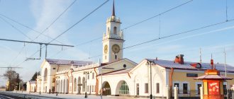
through the Zhigulevsk railway station in the directions “Samara - Ulyanovsk”, “Moscow - Tolyatti”.
The street map of Zhigulevsk shows 11 public transport routes, which are represented by buses and minibuses.
Sights of the city of Zhigulevsk
- “ Samarskaya Luka ” is a national park that includes natural attractions:
- Molodetsky Kurgan is one of the peaks of the Zhiguli Mountains. The height is more than 240 m. The panorama of the Zhiguli Sea is clearly visible from the top.
- Mount Camel and its abandoned limestone mines are attractive to climbers.
- The Stone Bowl is a stone cauldron containing the Nikolsky spring with holy water.
- The exhibition of the A. Shiryaevets Museum in Shiryaev is dedicated to the work of the Samara “peasant” poet who lived at the beginning of the 20th century.
- I.E. Repin Museum is the artist’s house in the village of Shiryaevo. The exhibition includes household items and paintings.
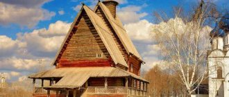
- The Church of the Icon of Our Lady of Vladimir is a functioning wooden church. Erected at the end of the 20th century.
- The Museum of Ufology is an unusual museum in the village of Zhiguli, introducing visitors to anomalous phenomena.
REFERENCE
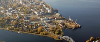
Zhigulevsk is located on the right bank of the middle Volga in the northern part of the Samarskaya Luka National Park in the valleys of the Zhigulevsky Mountains. Year of foundation: 1952. Area: 60.7 square meters. km. Population – 57.6 thousand people. Distance to Samara – 96 km. The city includes the village of Yablonevy Ravine, the village of Zolnoye, the village of Bogatyr, the village of Shiryaevo and the village of Bakhilova Polyana.
Zhigulevsk is connected by railway to the Syzran railway junction and is one of the links in the ring road around Samara Luka (Syzran-Zhigulevsk-Samara-Novokuibyshevsk-Chapaevsk-Oktyabrsk-Syzran). The Moscow-Samara highway of all-Russian importance passes through the city.
Main rivers – Volga
Economy . The main industries are electric power, mechanical engineering, mining and production of building materials, food industry, pharmaceutical industry, etc.