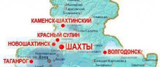
| Where to go by car Natural attractions Architecture Routes and tips Where to stay Interesting excursions |
The Rostov region is a constant object of attention for travelers by car. There are many reasons for this: favorable geographical location, accessibility, developed infrastructure of the region, interesting “neighbors”. And also, of course, many attractions of the Rostov region - natural, man-made, historical, entertaining, educational. It is very easy to verify this.
Travelers often pass through the Rostov region when traveling to the south. However, not everyone knows that transit through the Don region alone is not the best solution. It’s worth staying here for a couple of days - if you’re by car, you can see a lot of interesting things. Nature reserves, open-air museums, cities with a history of many centuries, seaside resorts - where to start your voyage around the Rostov region, read in our review material.
Capital Rostov-on-Don Photo: © Julia Alisova
The most interesting places in the Rostov region - TOP-3
A great number of natural monuments and reserves are registered on Rostov soil. Every tourist should see the most impressive creations of nature.
Biosphere Reserve "Rostovsky"
- Coordinates on the map: 46.464722, 43.050556.
The main natural reserve of the region has the status of a reserve of federal significance and covers the territory of the Remontnensky and Oryol districts, which is about 9,500 hectares. Most of the reserve, founded at the end of 1995, is occupied by endless desert steppes with saline soil, so the local flora is resistant to salts. The flora includes more than 400 species, 6 of which are included in the Red Book of Russia and another ten are listed in the Red Book of the region.
Many insects flock to the fragrant plants, including such rare species as the steppe bumblebee, Hungarian ground beetle and Bolivaria short-winged. Numerous birds nest near the river, including endangered species.
Wolves and foxes prowl along the valley steppes of the Manych River, horned saigas and delightful Manych mustangs gallop. In the grass you can see nimble field rodents, hares and hedgehogs. Tourists should be careful: there are a lot of snakes crawling on the ground, most of them are non-poisonous, but quite aggressive. Feeling a threat, reptiles can attack a person and bite the skin until they bleed.
Mountains Two Sisters
- GPS coordinates: 48.120571, 40.733055.
The two peaks are not the only mountains on the shore of the Northern Donets, but they stand out among their neighbors due to their height and extraordinary similarity to each other. Many people note that the twin mountains look like gigantic reptiles. It’s as if two huge lizards with protruding stone ridges have crawled to a watering hole and are lying side by side, with their heads directed towards the river.
The area has long been overgrown with myths and legends; the most famous one says that the peaks are enchanted sisters. Scientists give a very specific and realistic explanation for the natural phenomenon.
The hundred-meter-high mountains were formed about a million years ago as a result of the movement of the earth’s crust, when giant layers of limestone rose to the surface of the earth and over time became overgrown with greenery. Today, a floodplain forest separates the mountains at the foot, and clean freshwater springs rustle among the trees.
Long, or Long Canyon
- Coordinates: 48.228853, 40.349719.
A delightful canyon in the Kamensky district is a piece of the North American landscape in the middle of the steppe of the Rostov region. At the foot of the cliff flows an azure river, whose waters are so clean and transparent that through them you can see almost every pebble at the bottom.
Oddly enough, this amazing attraction appeared only in the last century and partly due to the fault of man. During Soviet times, there was a quarry here where stone was mined for construction work.
One day the quarry began to fill with groundwater and the huge pit was flooded to the very top in a matter of hours. Some of the equipment remained under water, which they did not have time to lift to a higher ground. The river is still fed by underground springs, so its waters remain cold even in hot weather.
Merzhanovsky lighthouse
- Address: Merzhanovo village, Neklinovsky district.
Not far from Taganrog, near the village of Merzhanovo, there is this man-made landmark of the Rostov region, which appeared relatively recently - as a set for the film “The Lighthouse Keeper”. Today, tourists happily visit this exciting place, mentally immersing itself in the distant past.
Loga Park
- Address: Loga Park, village. Staraya Stanitsa
In the area of the village of Staraya Stanitsa, near Kamensk-Shakhtinsky, there is Loga Park, where visitors can enjoy a lot of interesting entertainment and attractions, including the most popular - Crooked Mirrors. This place was included in our rating because it is truly unique - there are only a few like it in all of Russia. As the reviews say, when you relax here, you relax your soul!
Southern Bird Park "Malinki"
- Address: Krasny Sulin, PSH Sokolovskoye.
An interesting recreation park of regional significance is located near Novoshakhtinsk. “Malinka” itself will delight you with a unique “collection” of birds that you can see with the whole family. The territory is well designed, there is a lot of interesting things here, there are gazebos and bungalows near the shore of a neighboring reservoir, and beaches.
LiveInternetLiveInternet
Quote from TatiRoss message
Read in full In your quotation book or community!
48 interesting places in the Rostov region
1. Healing mud of Lake Gruzskoe
Gruzskoye is a salty mud lake in the southeastern part of the Oryol district of the Rostov region. Belongs to the Manych lake group of reservoirs of relict (marine) origin. Lake Gruzskoe is located north of Lake Manych-Gudilo, from which it is separated by a flat hillock up to 3-5 m high. The slopes of the hillock are gentle. The lake has a fairly regular elongated oval shape, about 10.5 km long and 1.5 km wide. The shores of the lake rise up to 3 m in places; several steppe ravines flow into it. On the northern shore of the lake is the village of Manych. The lake produces brine, the mineral water of the lake. The amount of brine depends on the air temperature (season of the year) and the amount of precipitation. In the absence of wind, the brine is evenly distributed over the surface of the lake bottom. When the wind blows, it quickly moves to one side, sometimes exposing 2/3 or more of the lake bottom. The surface of the lake with brine is always smooth and mirror-like. Rapa has a bitter-salty, burning taste; The brine is oily to the touch. The temperature of the brine fluctuates according to the seasons of the year. In summer, it reaches 20–38 degrees thanks to the high and steep banks that protect the lake from the wind. Since the 17th century, the Manych climate clinic has been operating on the shores of Lake Gruzskoe. Treatments with mud, brine baths and kumiss were carried out here. At the beginning of the 19th century, the hospital was closed and resumed operations in 1886. The operation of the hospital was entrusted to the manager of the mining and salt units in the region of the Don Army V.A. Wagner and doctor I.I. Vladykina. In 1908, the sanitary station received the name “Wagner”. On April 10, 1909, the “Regulations on the Wagner Manych-Gruz Sanitary Station” were approved by the highest order. Systematization and analysis of the collected materials allows us to divide the entire period of time from the beginning of the discovery of the medicinal properties of brine and mud from Lake Gruzskoye into four periods by type of use: the first period - episodic use by traditional medicine, the second period - the first experiments of specialists, the third period - organized treatment on a scientific basis, period four - episodic use by medical institutions outside the area of Lake Gruzskoye. The healing properties of Lake Gruzskoye The healing properties of the lake include, first of all, brine and mud. Brine is the name given to the mineral water of the lake, which in terms of table salt content is similar to the mother brine, but differs from it in that its concentration occurs naturally. The color of the brine changes throughout the year: in early spring, when it is heavily agitated by the yellowish snow and rain water flowing into the lake, in July, after settling, it acquires a brownish color, sometimes turning red. The amount of brine depends on the air temperature (season of the year) and the amount of precipitation. According to physical and chemical indicators, they belong to the type of silt mud of seaside reservoirs and are close to the famous Kuyalnitsky mud. The mud is radioactive and highly plastic. In terms of plasticity, the mud of Lake Gruzskoe surpasses all studied medicinal muds. With the help of the mud and water of the lake, you can cure many bone and skin diseases, anemia, nervous system, diseases of the spinal cord and brain, chronic diseases of the digestive system, metabolic disorders, diseases of the musculoskeletal system, and gynecological diseases. Operating reserves are inexhaustible. They amount to 4,226,651 m3 and exceed the combined reserves of mud lakes of the Saki (1,000,000 m3) and Tambukan (1,272,000 m3) deposits and can serve as the base for a specialized mud resort of any capacity. Razdorsky Historical and Ethnographic Museum-Reserve The Razdorsky Ethnographic Museum-Reserve was organized on the basis of the plan and with the personal participation of the writer Anatoly Veniaminovich Kalinin. In his letter to the Chairman of the Council of Ministers of the RSFSR, M.S. Solomentsev. The writer formulated the task - within the boundaries of the future museum-reserve to concentrate both the most valuable historical and ethnographic array of the middle Don, and the unique beauty of natural places with indigenous lands of the unique right-bank Don viticulture. Don Lukomorye In the southwest of the Rostov region there are wonderful places: the coast of the Azov Sea, the bend of the Taganrog Bay - a real fabulous Pushkin Lukomorye. This steppe remembers the Scythians and Sarmatians, the Amazons and the warriors of Tamerlane... These shores met the Greeks and Venetians, merchants of the Great Silk Road, the Argonauts and Odysseus, the Turkish khans and Peter. Embankment of the Don River in Rostov-on-Don Embankment of the Don River - in the city of Rostov-on -Don starts from the business and ends near the pier of the Pier restaurant. It runs along the right side of the river, and on the left side of the Don is the so-called Levberdon. The city embankment, named after one of the most famous Russian naval commanders, Fyodor Ushakov, is one of the most famous attractions of the city. {more} Staraya Stanitsa. Loga Park - “Little Switzerland”
Perhaps this is the best free park in Russia. In a small Don farm, its own little Switzerland completely unexpectedly appeared. Over a hundred sculptures, a rabbit hole, crooked mirrors, a rock garden, stunning bridges and gazebos, a water mill, a river, a lake, waterfalls, live deer, swans, peacocks, a sea of greenery, flowers... And all this is outdoors and free for everyone. Pelenkino - medicinal mud lake The small lake Pelenkino in the Azov region has unique medicinal mud, the composition of salts being close to Saki, Manych and Tambukan, mined near Pyatigorsk. (Wow) Gray Manych.
The Manych reservoir is located in the Rostov region, 65 km east and southeast of the regional center, within the Kuma-Manych depression on the Manych River, or Western Manych (the river flows in Kalmykia, the Rostov region and the Stavropol Territory). The Manych is a left tributary of the Don and enters the Don basin. How much feather grass? 88. Ethno-archaeological complex “Lost World”
In one of the most famous and celebrated places of the Don, in the Ust-Donetsk district of the Rostov region, where the great river seems to reluctantly turn in the sun in one direction or the other, the Pukhlyakovsky farm is located. These are the famous Kalinin places - those where the writer Anatoly Kalinin lived and worked, familiar to most from the film “Gypsy”, based on his book. 99. Karaul Mountain in the Rostov region (place described by Prophetic Boyan)
“Isn’t it stupid for us to talk, brethren, to begin with old words of difficult stories About Igor’s cry, Igor Svyatslavlich? Start your song according to the epics of this time, and not according to Boyan’s plans. Boyan, the prophetic one, if someone wants to create a song, his thoughts spread across the tree, like a gray fork across the earth, like a crazy eagle under the clouds. Let’s remember the strife of the first times”... 110. Aksai catacombs
Aksai catacombs, a mysterious and mystical place, is located in the suburbs of Rostov, the city of Aksai. The tunnels stretch for many kilometers and their total length is more than a hundred kilometers, and this is only a known part of them. The catacombs are clearly of artificial origin, and the time of their construction has not yet been established, but most likely they are more than one thousand years old, and who created this system of underground passages has also not been established. 111. Skeletal rock (Krasnosulinsky district) This is where my entire childhood was. I don’t even know. It seems to me that almost all of Krasny Sulin is on such skeletal hills. There are a lot of them there.
The Skelevataya rock is located on the outskirts of the city of Krasny Sulin, in the village of Skelevatka. The name of the rock, according to one version, comes from the word “skeleton” - the layers of rocks in the massif are very similar to ribs. And according to another version - from the Ukrainian word “skelya” (“rock”). If you stick to this theory, you get a funny name - "Rocky Rock". The length of the massif is over one kilometer, the height of Skelevataya Rock reaches 25 meters. 112. Underground monastery (Migulinsky caves)
A real miracle - an ancient underground monastery, carved into a chalk hill, is located in the very north of the Rostov region, a few kilometers from the village of Migulinskaya, Verkhnedonsky district. The catacomb monastery complex is located in an 80-meter cliff above the Don and consists of two caves - Old and New. The names “Old” and “New” are arbitrary. Both cave complexes were cut down at the same time. It’s just that our contemporaries found the entrance to the New Cave later. 113. Long canyon in the Rostov region
The belief that the Rostov region is continuous steppes is refuted by unique natural and man-made objects that we can be proud of. The Long Canyon is the largest flooded quarry in the Rostov region. The length of the lake in it is 2 kilometers 200 meters. It is located in the Kamensky district, 30 kilometers from Kamensk-Shakhtinsky, near the village of Chistoozerny. 114. Azov is the most ancient city of the Don region. City of bandits. Azov (former names Azak (XIII-XIV centuries), Tana (XV-XVI centuries) is a city in the Rostov region, the administrative center of the Azov region. Population - 81,995 people (2015). The first fortified settlements were formed on the Azov land more than two thousand years ago. 115. The village of Starocherkasskaya is the lost capital of the Don Cossacks. There is no more interesting place on the Don associated with the history of the Don Cossacks than the village of Starocherkasskaya. The village of Starocherkasskaya is located 27 km east of Rostov-on-Don. One of the oldest Don Cossack villages. From 1644 to 1805 - the capital of the Don Cossacks. Since 1970, on the initiative of M.A. Sholokhov, the Starocherkassk Historical and Architectural Museum-Reserve was formed here. 116. Chekhov Taganrog
Taganrog is the birthplace of the great Russian writer A.P. Chekhov. Anyone who lives in the Rostov region or comes here to stay is simply obliged to visit Chekhov’s places. “After Moscow, I love Taganrog most of all,” wrote Anton Pavlovich Chekhov. 117. Archaeological Museum-Reserve Tanais Tanais was founded in the 3rd century. BC e. Greeks, immigrants from the Bosporan kingdom, on the right bank of the former main branch of the mouth of the Tanais River (now Don) - the Dead Donets, after which the city received its name. 118. Rostov Zoo
Rostov Zoo is one of the largest zoos in Russia (with an area of almost 90 hectares), a zoological park rich in its traditions. Located in Rostov-on-Don. Even he was not spared by the corrupt suckers. 119. Rostselmash Rostselmash is a Russian company, one of the five largest global manufacturers of agricultural machinery. Consisting of 13 enterprises. Production sites in the countries: Canada, Russia, USA, Ukraine and Kazakhstan. 220. Don Father
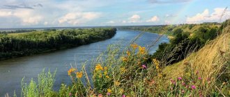
Don (ancient Greek Τάναις - Tanais) is a river in the European part of Russia. In terms of its catchment area, equal to 422 thousand km², in Europe it is second only to the Volga, Dnieper and Danube. The length of the river is 1870 km. The source of the Don is located in the northern part of the Central Russian Upland, at an altitude of about 180 m above sea level. 221. State Museum-Reserve of M. A. Sholokhov
The State Museum-Reserve of M. A. Sholokhov was created in 1984 and is the only state museum of the writer in Russia. Located in the Rostov region. The basis of his collection is memorial items that belonged to M. A. Sholokhov and his family. 222. Rostov Academic Drama Theater named after Maxim Gorky - “Traktor” The date of foundation of the theater is considered to be June 23, 1863, when the first performance of the stationary drama troupe took place. The theater building was built in 1935 and restored after the war in 1963. 223. Rostov State Musical Theater - “White Piano”
Rostov-on-Don is one of the oldest centers of musical life in the south of Russia. In 1919, the Rostov Musical Comedy Theater arose here, and in January 1931 it received state status. 224. State Natural Biosphere Reserve "Rostovsky"
The reserve is located in the southeast of the Rostov region, in the Oryol district, its total area is 9532 hectares. Reserve "Rostov" on the map https://yandex.ru/maps/-/CBUgzJacdA 225. Novocherkassk Ascension Cathedral - Second Sun of the Don . The Patriarchal Ascension All-Cossack Military Cathedral is one of the main attractions not only of Novocherkassk, but also of the entire Rostov region. He is called the “second sun of the Don”. 226. Rostov Arena Stadium
Football stadium on the left bank, built in 2022 specifically to host matches of the 2018 FIFA World Cup. The facade along the entire perimeter is made using media facade technology. 227. Zaitsevskie rocks, Krasnosulinsky district
A picturesque corner of the plain between a river, stream, grove and steep cliffs. A place for amateur and professional climbers. The most visited natural climbing wall in the Rostov region. The rocks are made of sandstone. Their height is up to 25 meters. 228. Merzhanovo A wonderful picturesque place overlooking the bay and with photogenic scenery from the film “The Lighthouse Keeper”. It is located near Rostov on the way to Taganrog near the village of Merzhanovo. 229. Levoberezhny Park
A park on the left bank of the Don, which was built for the 2018 FIFA World Cup. The park has many benches, exercise equipment, walking areas and paths for cyclists. 330. Park named after the October Revolution in Rostov-on-Don
Located in the city center near Theater Square, it is one of the popular places to relax. It houses many entertainment venues, a skating rink, a Ferris wheel, children's attractions, and a rope park. At night, beautiful illumination turns on. A must visit! 331. Film cluster “Don” in the fortress of St. Anna The film cluster is located in a fortification near the village of Starocherkasskaya, Rostov region. The fortress is a branch of the Starocherkassk Museum-Reserve. This is a monument to the military-defensive architecture of Russia in the 18th century. It was built in 1731. Construction is still underway. Filming locations will be divided into two zones. The first will consist of Russian scenery, architecture of the 18th-20th centuries. In the other they want to locate the embankments of Italy, France, England and Germany. 332. Recreation center "Eldorado"
The Eldorado recreation center is a picturesque place located in a picturesque canyon on the shore of a blue lake. On the territory there is a children's playground, a bathhouse, several bars, a night club, a shop, a sports equipment rental point, a paid parking lot, and gazebos with barbecue areas. "Eldorado" is located 140 km from Rostov-on-Don and 10 km from Kamensk-Shakhtinsky. 333. House of Faina Ranevskaya
Address: st. Frunze, 10, Taganrog. Soon, a museum of this famous actress will appear in this house (the deadline for completion is 2019). Local residents also consider the “Freken Bock” coffee shop, which opened nearby in 2009, to be a truly real monument to the actress. 334. Taganrog stairs and Taganrog embankment
The staircase is one of the attractions of Taganrog, length - 108 m, width - 6.5 m. It leads to the picturesque Pushkinskaya embankment. Laquiera Castle
A unique estate complex. Popularly, the main house of this complex was called “Lakiera Castle”, as it was built in the style of a medieval castle (pseudo-Gothic style). Address: Miusskaya st., 4, Zolotaya Kosa village House-Museum of P.I. Tchaikovsky
About the building, which is now called the Tchaikovsky House, the great Russian writer Anton Pavlovich Chekhov wrote to his brother: “If I were rich, I would certainly buy the house where Ippolit Tchaikovsky lived.” Indeed, this house is very beautiful. Built on a high, steep green cliff, made of bright red brick, with a crenellated tower, a high spire and medieval-style windows, the mansion gives the impression of a real castle. In addition to the fact that this house itself is of enormous cultural and architectural value, the great composer Pyotr Ilyich Tchaikovsky also visited here when he visited his brother. Today there is a museum dedicated to the composer and a chamber concert hall. Address: Grecheskaya st., 56, Taganrog Memorial of Glory at Sambek Heights
A memorial complex erected in the Neklinovsky district of the Rostov region near the village of Sambek in honor of the soldiers of the 130th and 416th rifle divisions, awarded the honorary name “Taganrog”. Tachanka (monument)
Tachanka-Rostovchanka - a monument (monument) built in the year of the 60th anniversary of the Great October Socialist Revolution. Dedicated to the First Cavalry Army during the Civil War. Fisherman's district Bogudonia
Bogudonia (or where this area is now located) has long been inhabited by fishermen. The brave “sea wolves” built houses as and where they had to, so today the area is an interweaving of narrow streets with small houses huddled together. In addition to the fact that there were always shops with freshly caught fish, there were also workshops that repaired fishing boats and boats. Here, nets were knitted for fishermen, there were smokehouses, glaciers and other shops and establishments related to fishing. Botanical Garden of Southern Federal University A rich collection of tropical and subtropical flora of Australia, Southeast Asia and both Americas is presented in the greenhouse. The “Azov Steppe” exposition is a small corner of a virgin landscape, surrounded by pine and oak groves, with a special area allocated for medicinal and essential oil plants. The Botanical Garden Museum houses a large herbarium and a collection of seeds. Numerous paths and a special “Ecological Trail” are laid across the territory, designed for a two-hour walk. There are benches in the clearings. Along the way you can see a 300-year-old “dinosaur tree” of ginkgo, pedunculate oaks, juniper, and boxwood. Guides tell tourists interesting stories about the world of plants. In the Botanical Garden there is a store where they sell seeds and seedlings of zoned varieties of flowers and fruit trees. The educational center organizes children's clubs and a summer camp. Here, future botanists participate in the work of a biological laboratory, learn to collect samples, isolate and analyze DNA. On the territory of the garden there is a mineral spring named after St. Seraphim of Sarov. Its water is considered healing. Paramonovsky warehouses
A complex of warehouse buildings of the 19th century in Rostov-on-Don. Located on the banks of the Don, between Sokolov Avenue and Universitetsky Lane. Monument of federal significance.
Memorial to the rush of Soviet tankers to German airfields in the Rostov region in November 1942. The monument stands at the exit from the Don highway to the Tatsinskaya village, 220 km from Rostov. In December 1942, the offensive operation “Little Saturn” took place on the middle Don. Soviet troops, having broken through the fascist defenses, rushed to the rear of the fascist German troops, sweeping away all obstacles along the way. One of the targets of this operation was the German airfield in the village of Tatsinsky. Tankers of the tank corps under the command of General Badanov, passing deep behind enemy lines through the snow, in severe frost, on December 24, 1942, destroyed over 300 enemy aircraft at this airfield and Tatsinskaya railway station, destroying the “air bridge” created by Hitler’s Germany to provide assistance surrounded at Stalingrad by the 330 thousandth army of General Paulus. Desert Big Buruny
Among the endless expanses of fields and open steppe of the Verkhnedonsky region, the Bolshie Buruny desert strikes the imagination. This creation of nature stretches for several kilometers in the bend of the Peskovatka River near the villages of Solontsovsky and Morozovsky. It is hidden from the scorching southern sun by a deciduous forest. This, of course, is not the Sahara, but a micro-desert, but it is so unusual and amazing that it is worth admiring the place. The endless sands are mesmerizing. Experts say that these are glacial sands; they were brought here about half a million years ago by the waters of melting glaciers. This place looks amazing, in the valley of the Peskovatka River, in the middle of pine forests, as if some ancient titan poured out a giant Kamaz of sand and created a sandbox. Place on the map https://yandex.ru/maps/-/CBuDJ-G8oB Mountain “Two Sisters”, Rostov region In the Rostov region there is an unusual and beautiful natural monument - the Mountains Two Sisters, similar to each other like two drops of water. Hundred-meter mountains stand on the banks of the Seversky Donets River, not far from the town of Belaya Kalitva. The mountains were formed as a result of the shifting of the earth's crust and are layers of volcanic rocks. The mountains are similar not only with identical slopes at an angle of almost 45°, but also with two limestone layers about 10 meters thick running from top to bottom, unique natural stone ridges. On the southern side of the mountain there is a floodplain forest and a spring of clean water. Near the mountains there are large deposits of Donetsk coal. According to numerous legends, countless treasures are buried at the foot of the mountains. Place on the map https://yandex.ru/maps/-/CBUkeQXn3C Shchepkinsky forest
The largest natural planting in Rostov is in the northern part of the city, and our summer cottages are nearby. Named after the Shchepkinskaya ravine, located on the site of the current forest. In addition, according to some sources, the reserve was named after the nearby settlement of. Shchepkin. Length of the park: from north to south - 4 km, from west to east - 4-4.5 km. At the beginning of the 20th century, in the Rostov region, near the village of Shchepkino, it was decided to begin planting tree crops. This became the background to the creation of the Shchepkinsky Party Reserve. It is known that the reserve was planted for breeding various species of animals on its territory, but the idea failed and economic activity was curtailed. There are forested areas left that impress with their picturesqueness. The extensive forestry contains a wide variety of vegetation types. Today the Shchepkinsky forest is the largest man-made forest plantation near the city limits of Rostov. Residents of Rostov love to spend holidays on the territory of the reserve because of the picturesqueness of these places. In addition to holding holidays, townspeople organize various games here, and paintball competitions are held. Shchepkinsky forest on the map https://yandex.ru/maps/-/CBuHFJfzxB
Beglitsky Spit
The Beglitsky Spit is an alluvial sand and shell spit, located on the northern Russian coast of the Sea of Azov, in the Taganrog Bay, approximately 25 km west of the city of Taganrog. There are several small freshwater lakes on the spit, which usually dry up during the hot summer months. Also on the spit are abandoned buildings of the Orlov fish collective farm (several brick barracks, and a pier destroyed by the surf) and, at the extreme eastern end of the spit, a lighthouse. The bay between the spit and the shore, which has an almost circular shape, is shallow and freshwater, mostly overgrown with algae. Due to the lack of any infrastructure on the spit, camping with tents is common. Few tourists are attracted by the large sand and shell beach (the share of quartz sand and shell rock reaches 70%) and mud procedures, since the bottom of the shallow bay of the same name is covered with a thick layer of silt (the so-called mulyaka) due to the release of sand and clay deposits in this place. The spit becomes suitable for full swimming only at high tide. The depth reaches 1 m only at a distance of 100 m from the shore. The shallow (in some places up to 50 cm) depth of the sea attracts families with small children, and thanks to the constant winds and the absence of high vegetation, the Beglitsky Spit is popular with hang gliders and paragliders. Beglitskaya Spit on the map https://yandex.ru/maps/-/CBuXm8wKpB "Ginkgo Park" in Novocherkassk
The history of the Park began in 2001, when landscape designer Alexander Tolokonnikov built the first private botanical park in Russia. In the steppe climate zone, on the site of an abandoned clay quarry in the city of Novocherkassk, Alexander created a unique garden - Ginkgo Park. Today, the Park is visited annually by several thousand people. During the warm season, psychological trainings and concerts, yoga and dance classes, film screenings and thematic meetings with interesting people, as well as classes at the School of Landscape Design are held here. The territory of the Park is divided into several zones and includes a classic English garden, an apothecary garden and a Japanese garden. The tea pavilion, located under a ginkgo tree on a pond in the Japanese garden, is its highlight. Species of this unique tree grew throughout the world tens of millions of years ago. Scientists have been able to identify at least ten different species, but all but the biloba have become extinct. In the Far East, ginkgo biloba is a symbol of love, happiness and wisdom. Monks plant it in holy places, near monasteries, considering the fan-shaped leaves to be similar to the two phases in Taoist philosophy - yin and yang. Address: Novocherkassk, st. Begovaya, 8. “Ginkgo Park” on the map https://yandex.ru/maps/-/CBuhrDWw1D Kazanskaya village - “Northern capital” of the Rostov region
Stanitsa Kazanskaya is the “capital” of the Verkhnedonsky district of the Rostov region. There is a border here, albeit not with another country, but with a region. Around are lakes and small rivers flowing into the Don. High school students are walking along the streets. And even the smallest resident will show you the house where Pushkin once stayed - because now there is a kindergarten in this building. And in 2009, a drawbridge was built here - now Kazanskaya can accurately be called the “northern capital”.{/more}
Rostov region: the most beautiful nature reserves
The main task of the Rostov nature reserves is to preserve and replenish the unique nature of the steppes and rare forests. In many protected areas, conditions have been created for recreation, fishing and hunting.
Natural Park "Donskoy"
- Coordinates: 47.184838, 39.285030.
The extensive natural park was founded in 2005, when it included four districts of the region with a total area of more than 40,000 hectares. The protected land is divided into two unequal sections: the large “Don Delta” and the smaller “Ostrovny”.
The fauna and flora of the first section are immensely rich even in comparison with the deltas of other large rivers; in the protected area there are more than 1000 species of birds, mammals and insects and more than 800 species of plants.
In addition to scientific and environmental activities, ecotourism is actively developing in the park; ecological trails and routes are being developed for guests of the reserve.
Mukhina beam
- Coordinates: 47.271565, 39.887148.
The large ravine in the vicinity of Aksai is a nature reserve and one of the most beautiful and mysterious places in the Rostov region. The area received its first name – Small Log – back in the 18th century. Later the log was renamed Ryabinovaya Balka.
Years later, the territory passed into the possession of the Mukhins, timber merchants, and the beam received the name of the new owners. The slopes of the ravine are covered with trees, as well as medicinal herbs and steppe plants, such as dandelion, feather grass, plantain, bluegrass, fescue, wormwood, etc. The bottom of the ravine is hidden under the dark waters of the swamps.
There is an unusual place in the beam that deserves special attention. Black holes gape on the bare sandy slope - entrances to underground tunnels. It is still unknown who created these caves; it is believed that the underground passages served as a refuge for the Cossacks. A little further away there is a museum of military equipment. An exhibition of tanks, armored personnel carriers and other vehicles was located right in the open air.
Despite its environmental status, the reserve suffers more and more from human activity every year. Forests and swamps are polluted, more and more plots of land are being given over to development.
Ilyichevskoe tract
- Coordinates: 47.133333, 42.611944.
Forest is a rare phenomenon for the Rostov region, so it is not surprising that the forest area near the Ilyichev farm received the status of a botanical monument. The tract is relatively small, its area is only 145 hectares. It came under state protection in 1985. It is home to dozens of bird species:
- pheasant and black kite,
- little bustard and eagle owl,
- owl and woodpecker,
- gray partridge and hawk,
- warbler and magpie,
- tit and many others.
The reserve is home to large populations of wild boars, roe deer and sika deer; large herbivores are hunted by local predators - jackals and wolves. The latter are found in three types - black, red and brown.
In 2002, an enclosure for breeding wild boars was built in the tract, and two years later new piglets appeared in the forest. Local specialists also work with other animals; during hungry winters, people feed roe deer and saigas and try to preserve rare species.
Tsimlyansky reserve
- Coordinates: 47.905000, 42.561389.
The lands from the Tsimlya River up to the Tsimlyansk Reservoir were recognized as protected areas in 1983. A significant part of the territory is covered with sand and looks like a desert. The desert image is complemented by sparse vegetation and snakes crawling along the sand. Nevertheless, the Tsimlyansky reserve boasts a variety of flora and fauna.
Most of the reserve is covered with forests and steppe. Dozens of years ago, experts planted pine trees in the reserve to strengthen the soil. Today, pine forests rustle at the planting site. In total, the reserve has several hundred plant species, of which 29 are listed in the Red Book.
About 230 species of animals, including 140 species of birds, have chosen the territory near the Tsimlyansk Reservoir. Birds hunt fish and nest on the shore. Many birds and insects are on the verge of extinction and are especially protected by the state. Tourists can see such rare species as the bustard and the great bustard, and if they are lucky, they can watch roe deer, deer and elk.
Chernyshevsky Sands
- Coordinates: 49.883333, 41.416667.
The forest tract in the Oblivsky district has been a specially protected area since 1977. The main task of the reserve was to stabilize shifting sands. For this purpose, pine, birch, acacia and other trees were planted on an area of 100 hectares. Today, medicinal herbs grow among the sands and overgrown plantings. Artificial forests have become habitats for hedgehogs, hares, foxes and other animals.
Kuleshovsky reserve
- Coordinates: 47.092726, 39.570996.
A large natural monument near the village of Kuleshovka occupies an area of about 10,000 hectares. The reserve acquired a special status in 1999. The protected lands are of great commercial importance; wheat, sunflowers, and vegetables are grown in the fields; fish, in particular silver carp and carp, are bred in the reservoirs.
Stocked ponds, numerous rivers, lakes and eriks, in turn, attract birds. Mute swan, pine tree, marsh harrier, greylag goose, bittern and many other feathered inhabitants nest on the banks. The most common mammals found on the site are foxes, muskrats, hedgehogs, weasels and hares.
Alexander Forest
- Coordinates on the map: 46.744386, 39.131027.
The Alexandrovsky Reserve, with an area of more than 5,000 hectares, was created in 1884 in the Azov region, one hundred kilometers from Rostov-on-Don. The mixed coniferous-deciduous forest is the habitat of dozens of animal species. In its open spaces one can find a raccoon dog, an owl, a heron, a fox, a hare and many other mammals and birds. Pheasants are bred on a farm in the central part of the reserve, and there is also a special nursery for deer.
During the season, for a certain amount of money you can hunt in the forest, but most tourists come just to admire the wonderful animals. Of particular delight are the red deer, which majestically stride among the trees and bushes, trying not to touch the branches with their luxurious antlers.
The flora of the Alexander Forest is no less diverse and interesting. The most valuable tree in the forest is a spreading oak, whose age exceeded 120 years. At the end of summer and autumn, mushroom pickers flock to the forest for a rich harvest of moss mushrooms, russula and lectinum. Guests of the reserve should be careful, as among the mushrooms there are poisonous ones, and the annoying moose fly often flutters in the air.
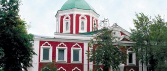
House-Museum of I.D. Vasilenko
House-museum of the writer I.D. Vasilenko. Taganrog, Rostov region. Photo: tgliamz.ru
The house-museum of the Soviet writer Ivan Vasilenko is located in Taganrog. He lived here with his family from 1923 to 1966, until his death. In this house, Vasilenko wrote several stories for children: “Star”, “The Life and Adventures of Zamorysh”, “Artemka in the Circus”, “The Magic Box”. In 2004, an exhibition was opened here where you can see the writer’s personal belongings, documents, drafts, journals and photographs. Four years later, an exhibition dedicated to the “Cycle of Works about Artemka,” one of Vasilenko’s main children’s characters, appeared in the house. The museum also houses an exhibition of paintings by artist Mikhail Sychev, a friend of Ivan Vasilenko.
Author: Irina Malakhova
High mountains and rocks in the Rostov region
The region's territory is predominantly flat, but its proximity to the Caucasus makes itself felt. In different parts of the region, remarkable mountains and cliffs rise, which look especially impressive against the backdrop of the steppes.
Avilovskie, or Avilov, mountains
- Coordinates: 48.184326, 40.807408.
The high cliffs in the vicinity of the city of Belaya Kalitva belong to the ancient Sarmatian mountains. The mountain slopes are covered with sparse vegetation, and well-trodden paths lead to the peaks. From the height there is a wonderful view of the Kalitva River, the city in the distance and the even rectangles of summer cottages.
Local residents like to fish at the foot of the mountains, and above them the black mouth of the Avilovskaya cave gapes. It is believed that the cave, like the mountains themselves, received the name of the hermit monk Avila, who escaped here many years ago.
Chalk Mountains
- Coordinates: 48.919645, 40.026822.
The remote Millerovsky district is fraught with a real pearl - entire mountains of chalk. The snow-white miracle of nature was formed millions of years ago, when an endless sea splashed in these parts. Islands of herbs and shrubs appear on the chalk slopes. In the spring, lemon thyme makes its way through the limestone deposits. The fantastic landscape is complemented by old dilapidated towers.
Mount Gorodishche
- Coordinates: 48.783333, 40.833333.
An amazing mountain flaunts not far from the Aleksandrovskaya settlement. The sand is replaced by stone boulders covered with moss and lichen, which, according to local residents, are becoming larger every year. In the stone kingdom there was also a place for living nature: the slopes are covered with centuries-old oaks and pines, and lilies of the valley grow on the top. The mountain is crowned with an observation tower.
There are several caves inside the mountain, and the underground passages hold many surprises. Thus, in some of them traces of primitive man were found - tools, dishes and inscriptions on the walls. It was because of the ancient sites that the peak received the name Gorodishche. Many centuries later, robbers were hiding on the mountain. Unfortunately, many finds were lost as a result of landslides: the tunnels were filled with sand and stones.
The settlement is shrouded in legends. According to one of them, a freshwater lake is hidden inside. Scientists were never able to find a reservoir, but they were able to determine from some signs that there may be sources of water in the depths of the mountain.
skeletal rock
- Coordinates: 47.906161, 40.038642.
A curious rock with a funny name rises near the village of Skelevatka in the Krasnosulinsky district. A kilometer-long wall up to 25 meters high protects the settlement from the winds. The sheer cliff attracts experienced rock climbers; it is not surprising that extreme sports enthusiasts often set up tent camps at its foot. The landscape of Skelevataya pleases the eye even for ordinary tourists; rare shrubs grow green on the reddish slopes, and a girder forest rustles in the north of the rock.
Taganrog Museum of History and Local Lore
Taganrog Museum of History and Local Lore. Taganrog, Rostov region. Photo: Alina Sbitneva / photobank “Lori”
The Taganrog Museum of History and Local Lore was opened on the initiative of Chekhov in 1898. It is located in an ancient building, which was built in the mid-19th century by St. Petersburg architect Andrei Stackenschneider in 1848. The palace belonged to Taganrog homeowner Nikolai Alferaki.
The museum exhibits are located in 15 halls. They talk about the history, culture and archeology of the Don region. Artifacts of the Stone Age culture, which were discovered on the territory of the North-Eastern Azov region, are stored here, as well as items made of bone, bronze and stone found during excavations of the Nizhne-Gnilovsky settlement, one of the six ancient city-states on the coast of Asia Minor.
Historical sights of the region
There are many places connected with history in the Rostov region. We suggest reading about the most famous of them - fortresses, castles and memorials - below.
Zmievskaya beam
- Address: Dovatora street, Rostov-on-Don.
In the northwestern suburbs of Rostov-on-Don you can find the Zmievskaya Balka Memorial to the victims of fascism. The place is very sad and tragic, despite the recent major renovation of the monument and the stunningly beautiful landscape compositions. Tells about innocent people killed during the Second World War.
Historical Museum-Reserve "Tanais"
- Address: Oktyabrskaya street, Nedvigovka village.
Near the village of Nedvigovka in the Myasnikovsky district there is a very interesting place for history buffs - Tanais Park. It was created on the site of a settlement that once served as one of the cities of the notorious Bosporan kingdom. Part of the complex is the Polovtsian sanctuary, the Meota Hut, as well as the museums of Historical Costume and History of Tanais.
Pavlovsk Fortress
- Address: x. Gaevka, Neklinovsky district.
Another interesting attraction is located on the Gaevka farm – the Pavlovsk Fortress. True, all that remains from full-fledged fortification are the fortress walls and their ruins. But here you can have a wonderful rest in nature, enjoying beautiful views and relaxing with a picnic.
Laquiera Castle
- Address: pos. Golden Spit, Miusskaya street, 4.
Near Taganrog, in the village of Zolotaya Kosa, near the very shore of the Sea of Azov, there is one of the most interesting castles in the Rostov region - Lakiera Castle, which was given to the famous historian and traveler of Imperial Russia. The building today is in a dilapidated state and requires major repairs. Despite this, dozens, or even hundreds of tourists come here every day, especially during the resort, spring-autumn season.
Museum of the History of the Don Cossacks
In the city of Novocherkassk, Rostov region, there is an ancient building, at the entrance to which there are two cast iron cannons. This is an architectural monument of the late 19th century. "Museum of the History of the Don Cossacks", founded in 1941.
The museum's collection has no analogues in the whole world and includes more than 190 thousand exhibits. It contains a collection of beautiful paintings (a sailing portrait of the 18th-19th centuries, portraits of atamans of the Don Army, Cossack portraits and many others); important documents and letters of commendation from village boards and the military office; there are very rare newspaper and book collections; firearms and premium weapons; costumes of military Cossacks.
This interesting and historical place is a whole museum complex, which, in addition to the main exhibition departments, also includes: Memorial House-Museums of I. I. Krylov, M. B. Grekov, Ataman Palace and one exhibition hall.
Beautiful Rostov lakes and waterfalls
The reservoirs and waterfalls of the Rostov region are not only beautiful from an aesthetic point of view, but also extremely valuable from a medical point of view.
Lake Manych-Gudilo
- Coordinates: 46.299718, 42.830451.
In ancient times, a vast salt lake-estuary connected the Caspian and Black seas. It is believed that Manych received the name “Gudilo” because of the roar of the winds and waves. The reservoir is considered one of the largest not only in Russia, but also in Europe, although its surface area decreases every year. Currently, the length of Manych is more than 150 kilometers, which makes it similar to a small sea.
Manych is not fed by rivers and streams, so the lake gradually dries up due to the hot climate. The reservoir is always open to the sun, since there are no trees on the banks. Despite its impressive size, the lake is quite shallow, with an average depth of approximately 4 meters. In the warm season, the water quickly warms up, and vacationers flock to the sandy beaches of Manych.
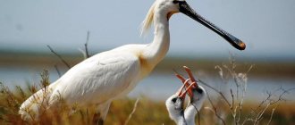
The lake is very salty, so only the most persistent fish, such as needlefish and various types of smelt, live in its waters. In the middle of Manych two islands protrude from the water - Vodny and Ptichy. Herds of wild horses live on Vodny; mute swan, laughing gull, spoonbill and other birds nest on Ptichy.
Lake Gruzskoe
- Coordinates: 46.423020, 42.708298.
The healing mud of the lake in the Oryol region became known far beyond the region. Gruzskoe, like Manych-Gudilo, is a relict reservoir of marine origin, so its waters are salty and not suitable for drinking, but are excellent for other purposes.
The healing properties of the reservoir became known back in the 17th century, at which time a hospital appeared on its banks, where patients were treated with mud, kumis and brine - lake water with a very high concentration of salts. Today, the Manych tuberculosis sanatorium is open near the lake.
Lake Pelenkino
- Coordinates: 47.007438, 39.463871.
Another body of water, famous for its healing mud, can be seen in the Azov region. In the 18th century, the lands on which the lake is located belonged to the landowner Yakov Pelenkin. Even then, local serfs noticed that the mud from the reservoir healed various diseases, and told the master about this.
More than a hundred years later, at the beginning of the 20th century, scientists studied the mud and confirmed its beneficial properties. In 1920, a medical and health sanatorium called “Salt Lake” was built on the shore of Pelenkino. The institution closed long ago, but tourists still come to the reservoir to see its life-giving power and simply enjoy nature.
Don waterfalls
- Coordinates: 48.144167, 40.044444.
The waterfalls near the village of Uglerodovsky are also called Volchensky because of their proximity to the village of the same name. The largest of the waterfalls of this attraction reaches 10 meters in height and has the romantic name “Two Tears”. You can find the most reviews about it online.
A smaller waterfall, called "Spits", is located on the opposite side of the Zamchalovsky quarry. The water brothers are not alike, each has its own character and its own “zest”. One stream flows steadily down the slope, the second noisily falls onto a pile of stones and scatters in a heap of splashes.
Literary Museum A.P. Chekhov
Literary Museum A.P. Chekhov. The building of the former men's classical gymnasium. Taganrog, Rostov region. Photo: Mikhail Markovsky / photobank “Lori”
The Anton Chekhov Literary Museum is located in Taganrog, in the building of a former men's gymnasium - the oldest educational institution in the South of Russia. The writer studied here for 11 years. Until 1975, a secondary school operated in the building, which bore his name.
The exhibition “The Writer and the Motherland” tells about Chekhov’s life in Taganrog. For the 150th anniversary of the writer’s birth, which was celebrated in 2010, a new exhibition was opened here. In it you can see books that were given to Chekhov by famous artists, performers and musicians, as well as photographs and his personal belongings: a hat, jacket, gloves.
Interesting places to stay in the Rostov region
Several attractions in the Rostov region deserve special mention. Most of these places are worth visiting in the warm season.
Pavlo-Ochakovskaya Spit
- Coordinates: 47.031189, 39.099101.
The Pavlo-Ochakovskaya Spit in the Taganrog Bay is an excellent place for a family vacation. Pleasant climate, warm Azov Sea, clean sandy beach - everything you need for swimming and sunbathing. The sea gives a light breeze, and steppe grasses fill the air with a delightful fragrance.
The descent to the depths is gentle, with virtually no sharp cliffs; the shore is quite shallow, so the bay is suitable for swimming with children. The bay attracts lovers of water sports, in particular windsurfing. For those who want to relax comfortably on the spit, recreation centers have been built.
Beglitsky Spit
- Coordinates: 47.125554, 38.579487.
The picturesque sand and shell spit in the Taganrog Bay is not as popular among tourists as other spits, but is valued among lovers of sports and recreation away from civilization. Visitors often set up entire tent camps on the shore, take mud baths from the bottom silt, swim in the sea at high tide and play sports. Thanks to the open terrain and strong winds, the spit is suitable for hang gliding and paragliding.
The nature of the braid is also interesting. More than 140 species of plants grow on the coast, seagulls and wild ducks nest. Rare mammals go to water in small freshwater lakes not far from the shore. In the hot summer, shallow reservoirs dry up and fill with water again in the fall. On the spit there are traces of human activity: the ruins of fish farm buildings from the times of the USSR and an old lighthouse.
Tulip Peninsula
- Coordinates: 46.885556, 42.029167.
An ordinary peninsula on the Manych River in spring turns into the most romantic place in the Rostov region. At the end of April, a multi-colored sea of wild tulips covers the ground, the wind sways waves of bright petals. Red, yellow, pink, white and even the rarest black flowers fill the air with a dizzying aroma.
Employees of the local nature reserve strictly monitor order so that tourists do not pick flowers or dismantle the luxurious meadow for bouquets. Feather grass, tartar grass, sweet clover, irises and other beautiful flowers and herbs also grow in the river valley. Every year near Manych the festival “Glorified Steppe” is held, dedicated to the nature of the steppe and the tulip peninsula.
Vodny Island
- Coordinates: 46.476263, 42.496709.
In the center of Lake Manych-Gudilo there is an unusual island, famous for its large population of wild horses. Its length is 12 km and its width reaches 4 km. It is still not known how wild animals got to the island in the middle of a salty reservoir. The Manych mustangs are looked after by the staff of the Rostovsky Nature Reserve; it is they who provide the animals with fresh water, which is not available on Manych.
Where else is it worth going in the Rostov region
The region has many caves, springs and relict trees recognized as natural monuments. Certain natural objects deserve special attention.
Avilova Cave
- Address: Avilova Gora.
The cave in the Avila Mountains is a hard-to-reach place with an interesting history. The underground passage was carved by hand under the very top of the rocky mountain. Three centuries ago, during the time of Emperor Peter the Great, the monk Avil, or Vavil, settled in the cave. Tradition says that the hermit previously escaped in a cave near the village of Rygin, but for some reason he moved to a mountain near the shore of Kalitva and spent 20 years here in fasting and prayer.
For his spiritual exploits, Avil acquired the gift of clairvoyance; many believers came to the elder for advice, until a severe flood forced him to leave the cave. History is silent about the further fate of the monk. Today, Avilova Cave has become a popular tourist attraction. It is better to get there under the guidance of an experienced guide: the path leading to the mysterious passage is very narrow and is located at the edge of the cliff.
Veshensky oak
- Coordinates: 49.671181, 41.709682.
A 25-meter giant oak grows eight kilometers from the famous village of Veshenskaya, the small homeland of the writer M.A. Sholokhov, glorified in his novel “Quiet Don”. The tree has two trunks of almost equal height and diameter.
It is believed that the age of the “old man” has long exceeded four centuries, which means he dates back to the times of Ivan the Terrible. According to legend, the oak tree was planted by the Tatar Khan near a treasure cache, but for many years no one discovered the treasure.