Vyazemsky
(Khabarovsk region)
OKATO code:
08217501
Founded:
1894
Urban settlement since:
1938
City since:
1951 City of district subordination (Vyazemsky district, Khabarovsk Territory)
Center:
Vyazemsky district
Telephone code (reference phone)
| 42153***** | — |
Deviation from Moscow time, hours:
7
Geographical latitude:
47°32′
Geographical longitude:
134°45′
Altitude above sea level, meters:
70 Sunrise and sunset times in the city of Vyazemsky
Geography[ | ]
Vyazemsky district is located in the south of the region. In the north and east it borders with the Lazo district, in the south with the Bikinsky district, and in the west, along the Ussuri River, with the People's Republic of China. The total area of the district is 4,318 km².
The territory of the region is located in the region of mid-altitude folded mountains and intermountain plains in the south of the Far East. The eastern and southeastern parts of the region are represented by the spurs of the Sikhote-Alin, the western and northeastern parts of the region are a plain with a large number of swampy and muddy depressions. The gentle slopes of hills, ridges and their smooth tops are used for arable land. The development of flat areas is hampered by swampiness and tussocks.
The large river is the Ussuri, but visiting the banks of the border river is limited; a pass is required to enter coastal settlements. Podkhoryonok is the second largest river in the Vyazemsky region. All other rivers flow into the Ussuri; they are shallow and low-water. There are no large lakes in the area; small floodplain lakes are located in the Ussuri Valley.
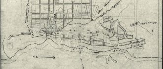
Map
| Vyazemsky: maps |
Vyazemsky: photo from space (Google Maps) Vyazemsky: photo from space (Microsoft Virtual Earth)
| Vyazemsky. Nearest cities. Distances in km. on the map (in brackets along roads) + direction. Using the hyperlink in the distance , you can get the route (information courtesy of the AutoTransInfo website) | |||
| 1 | Choir | 43 (45) | NE |
| 2 | Pereyaslavka | 52 (61) | NE |
| 3 | Korfovsky | 80 (154) | WITH |
| 4 | Bikin | 88 (98) | SW |
| 5 | Nekrasovka | 97 (147) | WITH |
| 6 | Khabarovsk | 108 (127) | WITH |
| 7 | Nikolaevka (Jewish Autonomous Region) | 113 () | WITH |
| 8 | Prince-Volkonsky | 116 (161) | NE |
| 9 | Luchegorsk (Primorsky Territory) | 126 (147) | YU |
| 10 | Smidovich (Jewish Autonomous Region) | 137 (228) | NW |
| 11 | Leninskoye (Jewish Autonomous Region) | 165 (434) | Z |
| 12 | Novopokrovka (Primorsky Territory) | 188 (270) | YU |
| 13 | Birobidzhan | 193 (301) | NW |
| 14 | Dalnerechensk | 194 (197) | SW |
a brief description of
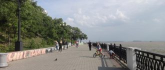
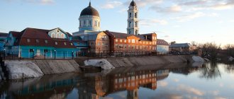
Located in the Ussuri Lowland, 130 km southwest of Khabarovsk. Railway station.
Territory (sq. km): 63
Information about the city of Vyazemsky on the Russian Wikipedia site
Historical sketch
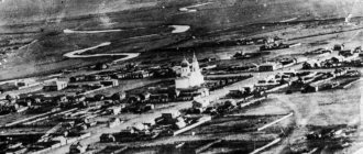
It arose in 1894 as a settlement at the Vyazemskaya station (opened in 1897). The name is named after the engineer Vyazemsky, the head of the construction of the Ussuri Railway.
Since 1938, the working village of Vyazemsky, a city since 1951.
Economy
Railway enterprises transport, woodworking plant. Lespromkhoz. Factories: vegetable canning, mechanical repair, brick, etc.
Main enterprises
FORESTRY, WOOD PROCESSING AND PULP AND PAPER INDUSTRY
JSC "Vyazemsky KLPH"
682340, Khabarovsk Territory, Vyazemsky district, Vyazemsky,
Offers:
Industrial wood, lumber, furniture
Culture, science, education
Branch of the Khabarovsk Museum of Local Lore.
Museums, galleries, exhibition halls
Vyazemsky Museum of Local Lore 682940, Khabarovsk Territory, Vyazemsky district, Vyazemsky, st. Kommunisticheskaya, 15 Phone(s): (42153) 31-160
| Population by year (thousands of inhabitants) | |||||||
| 1939 | 11.9 | 1996 | 17.8 | 2007 | 15.5 | 2015 | 13.6 |
| 1959 | 18.0 | 1998 | 17.8 | 2008 | 15.4 | 2016 | 13.3 |
| 1967 | 19 | 2000 | 17.5 | 2010 | 15.3 | 2017 | 13.2 |
| 1970 | 18.4 | 2001 | 17.3 | 2011 | 14.6 | 2018 | 13.0 |
| 1979 | 18.9 | 2003 | 15.8 | 2012 | 14.2 | 2019 | 12.9 |
| 1989 | 18.4 | 2005 | 15.7 | 2013 | 14.2 | 2020 | 13.0 |
| 1992 | 18.2 | 2006 | 15.6 | 2014 | 13.9 | 2021 | 13.0 |
Population[ | ]
| Population | ||||||
| 1917[6] | 1933[7] | 1939[8] | 1959[9] | 1970[10] | 1979[11] | 1989[12] |
| 8179 | ↗46 500 | ↗48 819 | ↘30 847 | ↗38 066 | ↘29 870 | ↗30 505 |
| 2000[13] | 2002[14] | 2004[15] | 2008[16] | 2009[17] | 2010[18] | 2011[19] |
| ↘29 500 | ↘25 879 | ↘25 865 | ↘25 300 | ↗25 315 | ↘22 974 | ↘22 946 |
| 2012[20] | 2013[21] | 2014[22] | 2015[23] | 2016[24] | 2017[25] | 2018[26] |
| ↘22 441 | ↘22 309 | ↘21 880 | ↘21 583 | ↘21 238 | ↘21 090 | ↘20 856 |
| 2019[27] | 2020[28] | 2021[29] | 2022[4] | |||
| ↘20 758 | ↗20 771 | ↘20 657 | ↘20 418 | |||
According to the 2002 census, the population of the district was 25,879 people (11th place among the regions of the region), of which 12,392 were men and 13,487 women (47.9% and 52.1%, respectively). The urban population is 67.4%, rural - 32.6%. The largest settlement in the region is the regional center - the city of Vyazemsky, with a population of 15,405 people[30].
Urbanization
63.49% of the district's population live in urban areas (the city of Vyazemsky).
Links[edit]
Notes[edit]
- ^ abcd Resolution No. 143-pr
- ^ ab Encyclopedia of Russian Cities
. Moscow: Great Russian Encyclopedia. 2003. p. 98. ISBN 5-7107-7399-9. - ^ a b Federal State Statistics Service (2011). “All-Russian Population Census 2010. Volume 1" [All-Russian Population Census 2010, vol. 1]. All-Russian Population Census 2010 [All-Russian Population Census 2010]
. Federal State Statistics Service. - ^ ab State Committee of the Russian Federation on Statistics. Committee of the Russian Federation for Standardization, Metrology and Certification. No. OK 019-95 January 1, 1997 “All-Russian classifier of objects of administrative-territorial division. Code 08 217”, ed. changes No. 278 / 2015 dated January 1, 2016. (Goskomstat of the Russian Federation. Committee of the Russian Federation for Standardization, Metrology and Certification. No. OK 019-95 January 1, 1997. Russian classification of administrative divisions) (OKATO).
Code 08 217 , as amended by Amendment No. 278/2015 dated 01/01/2016). - ^ abcde Law No. 191
- "On the Calculation of Time". Official Internet portal of legal information
. June 3, 2011. Retrieved January 19, 2022. - Post office. Information and computing center of OASU RPO. ( Post office
).
Search for postal service objects ( postal Search for objects
) (in Russian) - ↑
Federal State Statistics Service of Russia (May 21, 2004).
“The population of Russia, the constituent entities of the Russian Federation as part of federal districts, urban settlements, settlements, settlements of 3 thousand or more people” [Population of Russia, its federal districts, federal districts, districts, urban settlements, rural settlements - administrative centers and rural settlements with a population of more than 3,000 people] (XLS). All-Russian Population Census 2002
. - “All-Union Population Census of 1989. The current population of union and autonomous republics, autonomous regions and districts, territories, negative phenomena, urban settlements and rural district centers” [All-Union Population Census of 1989: current population of union and autonomous republics, Autonomous regions and districts , territories, regions, districts, towns and villages performing the functions of district administrative centers. All-Union Population Census of 1989 [All-Union Population Census of 1989]
.
Institute of Demography of the National Research University: Higher School of Economics [Institute of Demography of the National Research University: Higher School of Economics]. 1989 - via Demoscope Weekly
.
“Your name is an erased hieroglyph”
What does the word "Vyazma" mean? Many researchers agree that it was given by the name of the Vyazma River, on the banks of which the city stands. And the river is not easy. She makes such cool loops here that it’s amazing! So some believe that the intricate pattern of the riverbed suggested the name.
There is a version that “Vyazma” comes from the word “viscous”. Indeed, the city is surrounded by marshy areas. And someone insists that Vyazma knitted and knitted the route “from the Varangians to the Greeks.” And various authors mentioned elms that supposedly grew everywhere here. And the Finno-Ugric version was offered: “vesi-ma” - land on the water. It happened that the “all” tribe surfaced among the researchers, although the Krivichi lived here. There are many versions. But this is even more interesting. When did the city appear? The first written mention of Vyazma dates back to 1239. According to genealogical books, Smolensk Prince Vladimir Rurikovich gave the city as an inheritance to his son Andrei Vladimirovich, nicknamed the Long Hand. There are many ancient settlements in the Vyazma region (at the beginning of the 20th century, Ekaterina Nikolaevna Kletnova carried out excavations and looked for traces of ancient settlements), but the city can hardly begin its chronology from the 11th century. And there were attempts to “age” Vyazma. And all thanks to Saint Arkady, who performed such miracles both during his life and after death that the people of Vyazmich still remember them.
Transport
All passenger trains stop at Vyazemskaya station, and electric trains go to Khabarovsk.
The Ussuri federal highway passes through Vyazemsky. Bus intercity, intra-district and city transportation.
The timber-carrying Vyazemskaya narrow-gauge railway began in Vyazemsky; it was dismantled in the first half of the 1990s.
Guidebook
Only three three-tent churches have survived in Russia: in Vyazma, Uglich and Putinki near Moscow. And all because of Patriarch Nikon, who in 1652 ordered from now on that churches should “be built with one, three, or five chapters, and not build tent churches at all.”
However, the stone three-hipped, three-domed church in Vyazma appeared with funds allocated from the royal treasury and was built in honor of the icon of the Mother of God Hodegetria of Smolensk. The word “Hodegetria” translated from Greek means “guidebook”. This church became the precious pearl of Rus'.
In the 30s of the 17th century, a wooden church was dismantled on the territory of the St. John the Baptist Monastery. In its place, a stone church of the same name was built with two chapels.
Odigitrievskaya Church is a real Russian Gothic, a mixture of patterned and tented style. The masonry parts have sixteen different sizes and configurations. The bricks for the figured parts are three-color, and colored tiles are also used.
A distinctive feature is the voice boxes - a rare technique for Moscow architecture of the 17th century. Vocalists are ceramic pots embedded in walls to enhance and improve sound. It is believed that another of their tasks is to lighten the arches. There were 73 of them in total.
Opinions differ as to when exactly the church was built. The dates given are: 1634 and 1675. If in 1634, then I wonder how in 1654 Nikon looked at this beauty forbidden by him? In any case, Hodegetria is the latest hipped stone church in Rus'. In the 18th century, tented churches were no longer built.
Economics[ | ]
The basis of the economy of the Vyazemsky region is the forestry, food, mining, agriculture and railway transport. The region is part of the main agricultural zone of the Khabarovsk Territory, specializing in the production of soybeans, grain, potatoes, vegetables, dairy farming, and beekeeping. Among the main enterprises are:
- Amurmetall-Resource LLC - extraction of high quality limestone for metallurgical production;
- JSC "SM and K DV" - brick production;
- LLC "Vyazemsky Dairy Plant" - production of dairy products;
- LLC "Agro-business" - cattle breeding;
- LLC "TIS" - logging and wood processing;
- LLC "Ideal" - manufacturing of cabinet furniture;
- SPKK "Bacon" - production of dumplings and semi-finished meat products of various types.
The number of farms is 121 (2011).[35]
Your own Spasskaya Tower
There is little news about Vyazma in Russian chronicles. The second written mention of it in connection with the internecine struggle in the Smolensk lands dates back to 1300. Information about Vyazma in the 15th–16th centuries concerns the events of the struggle of the Moscow state with Lithuania and Poland. In 1493, after 90 years of being under Lithuanian rule, Vyazma became part of the Moscow state (this was enshrined in the peace treaty of 1494). Residents offered no resistance to the Moscow army and opened the gates of the city to the famous commander Daniil Shchenya.
For almost two centuries the city became a fortress protecting the approaches to the capital. During the struggle for Smolensk at the beginning of the 16th century, there was a base of Russian troops here. In 1565, Ivan the Terrible included Vyazma among the oprichnina cities and distributed many lands here to his associates - in particular, to Boris Godunov.
From 1606 to 1612, the city and its surroundings were devastated during the Time of Troubles. Of course, for a long time there was a fortress in Vyazma - a wooden one. In 1629, by decree of Tsar Mikhail Fedorovich, the governors were ordered to rebuild it. And in 1630–1632 this was done. The length of the Vyazma wall is over one and a half kilometers. Six stone towers were erected. Only one has survived - Spasskaya, a blind corner. The tower is 18.5 meters long, 17 meters wide, and its height is 14 meters (with a roof - 21). And before, they say, it was even higher.
Many stories and legends are associated with the Spasskaya Tower. Here they looked for treasures and underground passages (where the ghost of the Black Monk roams), supposedly connecting the entire city. Tsar Nicholas I did not allow it to be dismantled into bricks, and in 1943 the Nazis failed to blow it up - it survived.
Vyazma is the capital! And other royal affairs...
Vyazma is closely connected with the ruling dynasties. In 1566, Tsar Ivan Vasilyevich visited Vyazma and inspected the defensive fortifications. This trip of Ivan the Terrible was different from all the others: at the height of the oprichnina, only in Vyazma he did not carry out executions and massacres, but prayed intensely. He even left in the St. Nicholas Church (later the Holy Trinity Cathedral) a synodik with the names of the people he executed. I visited the Monastery of St. John the Baptist, founded on the northwestern outskirts of Vyazma in 1536 by the Monk Gerasim of Boldinsky. In 1598, Tsar Boris Fedorovich Godunov stayed in this monastery. He often visited Vyazma, since he owned lands here.
In 1626, Tsar Mikhail Fedorovich Romanov, after the death of Princess Dolgoruky, married the daughter of a poor Vyazma nobleman Lukian Stepanovich Streshnev - Evdokia Lukianovna. So the Vyazmichka became the queen, the wife of the first king of the Romanov family.
From October 21, 1654 to February 10, 1655, Tsar Alexei Mikhailovich, due to the plague epidemic that broke out in Moscow, stopped in Vyazma, returning from Smolensk. Patriarch Nikon and the entire royal family arrived here. A wooden palace and a palace church were built for them in the city. So Vyazma tried on the status of the capital. And he suited her. At the very beginning of the 18th century, Emperor Peter I created a supply base for the Russian army in the city and sent Tsarevich Alexei to Vyazma. Emperor Napoleon Bonaparte visited here twice, but, as they used to say after 1812, “Vyazma gingerbread got stuck in his teeth.”
Municipal-territorial structure[ | ]
The Vyazemsky municipal district includes 19 lower-level municipalities, including 1 urban and 18 rural settlements[31][32][33]:
| № | Municipality | Administrative center | Number of settlements | Population | Area, km² |
| 1e-06 | Urban settlement: | ||||
| 1 | City of Vyazemsky | Vyazemsky city | 1 | ↘12 963[4] | 63,14[3] |
| 1.000002 | Rural settlement: | ||||
| 2 | Avan village | Avan village | 1 | ↗711[29] | 4,09[3] |
| 3 | Village Venyukovo | Venyukovo village | 1 | ↘297[29] | 4,95[3] |
| 4 | Village Vidnoye | Vidnoye village | 1 | ↗130[29] | 3,77[3] |
| 5 | Vinogradovskoe | Vinogradovka village | 2 | ↘173[29] | 3,60[3] |
| 6 | Glebovskoe | Glebovo village | 3 | ↗280[29] | 5,78[3] |
| 7 | Dormidontovka village | Dormidontovka village | 1 | ↘1393[29] | 20,00[3] |
| 8 | Dormidontovka village | Dormidontovka village | 1 | ↘473[29] | 9,04[3] |
| 9 | Village Zabaikalskoye | village of Zabaikalskoye | 1 | ↘385[29] | 9,18[3] |
| 10 | Village Kapitonovka | Kapitonovka village | 1 | ↗510[29] | 13,07[3] |
| 11 | Village Kedrovo | village of Kedrovo | 1 | ↘89[29] | 7,21[3] |
| 12 | Kotikovskoe | Kotikovo village | 3 | ↘532[29] | 6,94[3] |
| 13 | Village Krasitskoye | Krasitskoye village | 1 | ↘535[29] | 8,95[3] |
| 14 | Village Kukelevo | village Kukelevo | 1 | ↘247[29] | 4,16[3] |
| 15 | Village Medvezhiy | Medvezhiy village | 1 | ↘90[29] | 2,43[3] |
| 16 | Otradnoe village | Otradnoe village | 1 | ↘787[29] | 10,86[3] |
| 17 | Village Sadovoe | village of Sadovoe | 1 | ↗239[29] | 1,58[3] |
| 18 | Sheremetyevo village | Sheremetyevo village | 1 | ↘561[29] | 9,86[3] |
| 19 | Shumny village | Shumny village | 1 | ↘256[29] | 4,99[3] |
Settlements[ | ]
There are 24 settlements in the Vyazemsky district, including 1 urban (city) and 23 rural[34].
| List of settlements in the region | ||||
| № | Locality | Type | Population | Municipality |
| 1 | Avan | village | ↗711[29] | rural settlement "Avan Village" |
| 2 | Venyukovo | village | ↘297[29] | rural settlement "Selo Venyukovo" |
| 3 | Vidnoe | village | ↗130[29] | rural settlement "Selo Vidnoye" |
| 4 | Vinogradovka | village | ↘195[20] | Vinogradovskoe rural settlement |
| 5 | Vyazemsky | city | ↘12 963[4] | urban settlement City of Vyazemsky |
| 6 | Goedicke | village station | →13[20] | Kotikovskoye rural settlement |
| 7 | Glebovo | village | ↘253[20] | Glebovskoye rural settlement |
| 8 | Dormidontovka | village | ↘1393[29] | rural settlement "Village Dormidontovka" |
| 9 | Dormidontovka | village | ↘473[29] | rural settlement "Village Dormidontovka" |
| 10 | Zabaikalskoe | village | ↘385[29] | rural settlement "Selo Zabaikalskoe" |
| 11 | Kamenushka | village station | ↗15[20] | Glebovskoye rural settlement |
| 12 | Kapitonovka | village | ↗510[29] | rural settlement "Village Kapitonovka" |
| 13 | Kedrovo | village | ↘89[29] | rural settlement "Selo Kedrovo" |
| 14 | Kotikovo | village station | ↗52[20] | Vinogradovskoe rural settlement |
| 15 | Kotikovo | village | ↗575[20] | Kotikovskoye rural settlement |
| 16 | Krasitskoe | village | ↘535[29] | rural settlement "Selo Krasitskoye" |
| 17 | Kukelevo | village | ↘247[29] | rural settlement "Selo Kukelevo" |
| 18 | Bearish | village | ↘90[29] | rural settlement "Village Medvezhiy" |
| 19 | Otradnoe | village | ↘787[29] | rural settlement "Selo Otradnoe" |
| 20 | Luxury | village | →1[20] | Kotikovskoye rural settlement |
| 21 | Sadovoye | village | ↗239[29] | Rural settlement "Sadovoye Village" |
| 22 | Snarsky | village station | ↘14[20] | Glebovskoye rural settlement |
| 23 | Sheremetyevo | village | ↘561[29] | rural settlement "Selo Sheremetyevo" |
| 24 | Noisy | village | ↘256[29] | Rural settlement "Shumny Village" |
TOP-3 - the most interesting places in the Khabarovsk Territory
Among the most impressive sights of the region are the amazing islands located near the sea border of the region.
Shantar Islands
- Coordinates on the map: 54.931862, 137.718839.
Shantar is a chain of islands in the Sea of Okhotsk. The archipelago consists of 15 uninhabited islands. They are believed to have been discovered in 1645 by the famous explorer Vasily Poyarkov, although the Cossack Ivan Moskvitin reported them five years earlier.
In 1926, a small settlement was founded on the largest island, called Big Shantar, whose inhabitants were engaged in fishing and whaling. The village existed for about 40 years, then production stopped, and the island eventually became deserted.
Shantarskie are covered with low mountains, overgrown with coniferous forests, which are home to hundreds of species of mammals and birds. You can see bowhead whales off the coast; many tourists come here to watch these stunning animals.
Due to the harsh climate, it is not easy to get to the islands, so the tourist season is very short - from July to September. In 2013, a national park of the same name was established on the archipelago.
Toki Island
- GPS coordinates: 49.168966, 140.348423.
A small island in the Tatar Strait in the Vininsky district is known as a large-scale rookery for walruses, Larga seals and sea lions. Pinnipeds come to Toki in the thousands, and then the shores become dark with many gray carcasses, and the air is filled with an incessant roar.
You cannot find another similar rookery in the entire Sea of Japan. In 1987, an island of land only 250 meters long received the status of a natural monument, and in 2007 it turned into a private reserve.
Arch Island
- Coordinates: 54.893660, 136.785194.
Cape Arka, near the border of Lebyazhya Bay, became famous thanks to the incredibly beautiful arched rock that occupies almost its entire territory. The rock is connected to the mainland, but many consider it an island. The giant stone gate can easily be called one of the calling cards of the region.
And it is not surprising, because it is difficult to ignore such an amazing creation of nature. There is a legend that the arch was created by giants, but scientists have found a simpler and more realistic explanation for its origin: the bizarre shape of the rock is the result of centuries of weathering.