- Reports and messages
- Miscellaneous
- Bryansk city
Bryansk is the administrative center of the region of the same name, which is located in the European part of Russia.
One of the oldest cities, founded as a Slavic fortress in 985. The original city was called Debryansk, because of the large forests around it, from the word wilds. The first mention in the chronicle dates back to 1146, when internecine strife took place between various principalities. At the same time, the city was destroyed. The survivors built a new city on Pokrovskaya Mountain. In 1252, Bryansk became the center of the principality of the same name and its role in Russian history gradually increased.
In 1356 the city was captured by the Principality of Lithuania, under whose control it was for more than 150 years.
In 1500, the city was besieged and taken by the Principality of Moscow. From that time on, it became one of the cities of the entire Russian state. Since the end of the eighteenth century, industrial enterprises, as well as the processing of agricultural crops, have rapidly begun to be built and developed in Bryansk.
In 1868, the railway was built, connecting the transport route with the rest of the country.
At the beginning of the twentieth century, difficult times began for the city, as well as for the whole country. But after the civil war and the establishment of Soviet power, Bryansk became one of the country's industrial centers. Factories and heavy industry enterprises are being built at a gigantic pace.
However, the heyday was not long - during the Great Patriotic War the city was destroyed.
After the war, Bryansk was quickly restored and continued its development. Currently, the city is considered one of the founders of the formation of Russian culture. In 2010, the President of the Russian Federation awarded the title “City of Military Glory”
Option No. 2
Russia is a huge country with a large number of cities, and Bryansk is one of them.
Bryansk is one of the oldest cities in Russia with a long and interesting history. It was founded around 985, but no one knows the exact date of its appearance; the city was first mentioned only in 1146 as “Debryansk”; it is believed that this name arose because of the dense forests around that surround Bryansk even now. At the moment, about 404 thousand people live in the historical city. The Bryansk region is located next to Ukraine and Belarus. Among the attractions one can note the Mound of Immortality, the Trinity Cathedral and other equally interesting places.
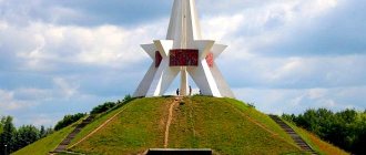
The Mound of Immortality is a monument to those killed in the battle with the Nazi invaders, built by Soviet architects in 1967-1976. The Mound of Immortality is a five-pointed star on a hill made of earth that was brought from the mass graves of the mothers of those killed in the war, the soldiers themselves and other people in any way connected with the war of 1941-1945. This memorial can be called the main attraction of Bryansk; people of different ages often organize meetings there, and sometimes you can meet veterans.
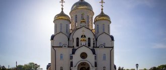
Trinity Cathedral is considered the largest temple in the Bryansk region. Previously, the Novopokrovsky Cathedral stood in its place, but it was destroyed in 1968, and it was decided to build a new one only in 2005.
You can also note some historical moments associated with Bryansk, for example, in 1607 the city was burned so that it would not fall to False Dmitry II, and at the end of the same year Bryansk was rebuilt. Another interesting fact is that City Day in Bryansk is celebrated on September 17th. This date is not accidental; during the Great Patriotic War, the city was occupied by the Germans, but on September 17, 1943, Bryansk was liberated by Soviet troops. The city was awarded the titles “City of Military Glory” and “City of Partisan Glory”.
Now Bryansk is divided into four districts: Sovetsky, Volodarsky, Bezhitsky and Fokinsky. Currently, 153 thousand people live in the Bezhitsky district; this district is the most populated of all four. The Sovetsky district is considered the second most populous, with about 111 thousand people living in it; it is also considered the center of Bryansk. Since until 1956 the Bezhitsky district was considered a separate city called “Bezhitsa”, many people still call themselves Bezhitsy. The remaining three districts appeared on June 22, 1951.
Bryansk is truly a remarkable city with a rich history; if you devote several days to walking around this city and visiting significant places, then the time will not be wasted and will remain in your memory for a long time.
Center for children and youth tourism and excursions in Bryansk
XVII city competition of research works of school local history students “Chronicle of the Bryansk Territory”In order to involve students in educational institutions of Bryansk in the study of national history, cultural and natural heritage of the Bryansk region through the organization of research activities, the XVII city competition of research works of students in school local history “Chronicle of the Bryansk Territory” is being held in Bryansk.
Students in grades 8-11 of general education institutions (including activists of school museums) and additional education institutions in Bryansk take part in the competition.
The competition is held in two rounds: the first round will take place from December 13, 2021 to January 14, 2022; the second round will take place on February 11, 2022.
Contestants prepare a local history research paper according to one of the subprograms of the tourism and local history movement “Fatherland”: chronicle of their native land, military history, fellow countrymen, cultural and natural heritage, my family tree.
The best research papers will be recommended for participation in the regional stage of the research paper competition in local history.
The competition is held as part of the implementation of a social project of a civil-patriotic orientation in the field of local history “Remember! We are proud! Let's inherit!”, implemented with the support of the Presidential Grants Fund.
Competition regulations
XIX Ser- Russian competition of educational and methodological materials to help teachers, organizers of tourism, local history and excursion work with students and pupils
In order to improve scientific, methodological, pedagogical activities aimed at ensuring high quality of additional education for children in tourism and local history, educational activities, organizing tourism and local history work with students in educational organizations of preschool, general and additional education in recreation and recreational organizations for children, Federal Center additional education and organization of recreation and health improvement for children holds the XIX All-Russian competition of educational and methodological materials to help teachers, organizers of tourism, local history and excursion work with students and pupils.
The Competition is open to management, teaching staff, methodologists and other specialists (individual authors and teams of authors) of educational organizations of all types, recreation and health organizations for children, sports, tourism, culture and others, as well as individual entrepreneurs organizing tourism and local history, excursion work with students.
Position
Popular message topics
- Apricot tree
Everyone has eaten ripe and honeyed apricots, dried apricots or apricot jam at least once in their life. In Russian latitudes this is a very popular summer fruit. These delicious fruits grow on a tree that bears the same name, - Arctic Ocean
The smallest of all the oceans on the globe is the Arctic Ocean. Of course, the only thing that distinguishes it from other waters is that it is located in a harsh climate zone. This significantly affects the temperature of ocean water, - Jean Jacques Rousseau
The French philosopher was born on June 28, 1712 in Geneva. His father raised him, since his mother died in childbirth. Isaac Rousseau had to work two jobs, but he found time to instill in his child a love of literature.
Historical and memorable places of the Bryansk region
The ancient city of Bryansk, whose name is associated with wilds, overgrown ravines, impenetrable forests and swamps, was founded no later than 985. The location of the settlement was initially connected with navigable river routes and was located in the Chashin Kurgan area, where the fortress walls were erected. For reasons that have not yet been clarified, the city changed its location and by the middle of the 12th century it had already finally established itself on the steep slopes of the right bank of the Desna on Pokrovskaya Mountain. Princely civil strife and frequent raids by the Crimean Tatars held back the development of Bryansk. Being a border settlement, Bryansk shared the complex dramatic fate of many Russian border cities - until in 1503 it legally came under the “power of Moscow”. Since then, it has become a fortress city on the southwestern borders of the Russian state. Only at the end of the 17th century did attacks by external enemies on Bryansk stop, and in the first half of the 18th century, with the removal of the state border, it lost its significance as a fortress city.
The foundations for the future urban development of the city were laid even earlier, when around the fortress city in the 17th century after the Time of Troubles, on the coastal strip at the foot of the Bryansk fortress, the Posad “Zatinnaya Sloboda” was built, and on the upper plateau, between Verkhniy Sudok and Bely Kolodez (Lower Sudok) , – “Streletskaya Sloboda”. Somewhat earlier, behind the posad (the territory between the fortress and the Petro-Paul Monastery), after the annexation of Bryansk to the Moscow state and the organization of the Yamskaya service in 1503, the “Yamskaya Sloboda” appeared. Zatinnaya Sloboda is located on the site of the ancient “Zhitnoy Gorod” - a fortified territory of food warehouses and salt storage facilities. Later, the settlement gave way to a cannon yard, on the site of which the Arsenal was located in the 18th century.
In 1780, Empress Catherine II “highly approved” the general plan of the city of Bryansk.
The plan laid the foundations for the development of the city in a regular system designed to streamline the development that had developed over centuries, limit the spontaneous growth of the city, and create a new public center. In the drawing, the territory of the upper plateau is covered with a geometric grid of blocks formed by streets descending to the Desna and perpendicular to them. Three squares were “strung” onto two of them: Sobornaya - on coastal Moskovskaya Street, Krasnaya Gorodskaya - in the center of the plateau, and the Shchepnaya market square - on the western border of the city (now here is the entrance to the Dynamo stadium). The plan captures the historical layout. The city is located on the right bank of the Desna. It was a picturesque group of different-sized, irregularly shaped blocks. The center of the city was not distinguished in terms of planning; it was defined by the fortress on Pokrovskaya Mountain, dominating the city. The streets descending from the upper plateau were united by one that followed the banks of the Desna. The city was almost entirely wooden, with the exception of only a few stone, mainly religious, buildings. The street network included all significant buildings at that time. The central blocks were designated for the construction of stone public, commercial and residential buildings. Red Square was to be decorated with buildings of government offices, magistrates and trade institutions; market square - to be equipped with craft enterprises, forges and shops.
The plan, revised in 1802, significantly increases the territory of the city and includes in the regular system not only the coastal area and the area between Sudki, but also the area of Petrovskaya Gora and Yamskaya Sloboda with Timber sheds in the north and northeast, the area between the Bely Kolodez ravine and the Podar river on south; increases the territory of the central part in the northwest behind the market square. Blocks are enlarged, streets are classified, and squares are placed on a larger scale within the city. The main highway connecting the mountainous part with the coastal part in the city center is Smolenskaya Street - in common parlance Rozhdestvenskaya Gora (now Sovetskaya Street - Gagarin Boulevard). It connects three squares: Sobornaya, Krasnaya and Sennaya (formerly Shchepnaya). Two other highways run in the longitudinal direction: Bolshaya Moskovskaya (now Kalinin Street) in the coastal part and Petropavlovskaya-Voskresenskaya Street (now Lenin Avenue), uniting the city in the mountainous part. Petropavlovskaya and its continuation Voskresenskaya streets, crossing the entire city, at the intersection with Trubchevskaya Street (now Krasnoarmeyskaya) ended in a new, fourth square - Khlebnaya (on the site of modern Partizan Square; there was once a mill on this site). From here there were roads to Trubchevsk and Karachev. All areas were square in shape. At the beginning of the 19th century, out of 867 houses in the city, only 25 were made of stone, and out of 17 churches, 10 were made of stone. A little more than a dozen buildings built in the second half of the 18th century have survived to this day.
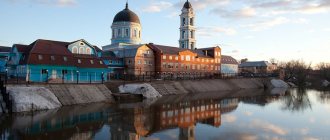
The oldest isographical evidence dating back to 1857 will help us figuratively imagine the color of the ancient city. This is a watercolor by the self-taught artist Gavriil Vasilyevich Khludov, a draftsman (according to other sources, a fireworks artist) of the Bryansk Arsenal, who captured the panorama of the city from the left bank of the Desna. In the center of the picture is the Pokrovskaya Mountain with the stone church of the same name and the bell tower, at the bottom right are the Arsenal buildings, then the Resurrection, St. Nicholas and Trinity churches, the ensemble of the Peter and Paul Monastery, and in the background is the Ascension Church of the Zaretskaya Sloboda. The right flank of the panorama is completed by the Tikhvin and Mitrofanievskaya churches. To the left of the Intercession Mountain we see the tented bell tower of the Spaso-Polikarpov Monastery and the temple complex of the Church of the Nativity. The closing link of the central part of the city was the Nizhne-Nikolskaya Church. Even further to the left, the ensemble of the Svensky Monastery is clearly visible. The overall picturesque coloring of the picture is complemented by the pronounced relief of the right bank of the Desna, the ravines - Podar, Nizhny and Verkhniy Sudki, and, of course, the abundance of green spaces, in the clumps of which are buried the vertical dominants of temples and a few individual buildings, reflected in the water surface of the Desna.
The unique architectural silhouette of the city, formed by the beginning of the 19th century, was skillfully supplemented and enlarged by the end of the century. In the center, on the territory of the Spaso-Polikarpov Monastery, the Novopokrovsky Cathedral (1862–1897) was erected, emphasizing with its scale the planning center of the county town. On the right flank, a building of a trade and vocational school appeared, built by the architect N. A. Lebedev, linking the building and the Tikhvin Church into a single chain of historical development. Old photographs show the important role of this building in the overall panorama of the city. Being a colorful accent of the coastal, lower part of the panorama, it connects it with the architectural crown of the monuments of the highland plateau. Already at the beginning of the 20th century, in 1904, the construction of the Spaso-Grobovskaya Church was completed according to the design of N.A. Lebedev, replacing the old wooden predecessor, erected on the site of the “lord’s coffins” - the burial place of Bryansk bishops. Its hipped vertical successfully connected some spatial gap between the St. Nicholas Church and the ensemble of the Peter and Paul Monastery. The majestic panorama of the ancient city, which grew in unity with the surrounding nature, enriched by the art of human creators, did not leave room for indifference and could not go unnoticed by contemporaries. Bryansk seemed like a fabulous vision to Konstantin Paustovsky, who saw the city “far away on the mountains,” shimmering “like a toy made of foil […] in shaggy patterns of frost.” The winter panorama of Bryansk appeared to V.I. Nemirovich-Danchenko as the mountainous bank of the Desna “with a mass of churches crowded above it, sparkling under the bright shine of the day with their domes, white walls, bell towers and crosses. The city buildings of Bryansk seem […] forged from frosted glass.” “Beautiful and free, spread out on the right, high bank of the Desna, immersed in greenery, with white churches standing out sharply from the general green background, all flooded with sunlight - it looks so visual, clean, self-satisfied.” “Everyone who had to come to Bryansk probably remembers what an impression the city, picturesquely spread over the mountains, made on him... Many compared Bryansk with Kiev...” Remembering post-war Bryansk in 1947, architect Z.I. Ozerova notes that the city was “entirely wooden, having not yet healed the wounds of the war.” The forest expanses surrounding the city made a deep impression. “Pictures of the spring flood, when the mirror of the Desna turned into an endless sea,” gave the suburban landscapes a revival and special picturesqueness.
Population of Bryansk
The population of Bryansk is 402,675 people. In terms of national composition, the main part are Russians and Ukrainians. In recent years, there has been a decrease in population growth, which can be seen from the table data.
| 2005 | 2006 | 2007 | 2008 | 2009 | 2010 |
| 424 100 | 420 000 | 416 200 | 413 900 | 411 798 | 415 721 |
| 2015 | 2016 | 2017 | 2018 | 2019 | 2020 |
| 407 256 | 405 921 | 406 553 | 405 723 | 404 793 | 402 675 |