The territory of the modern city of Nizhnyaya Tura has a rich and interesting history, dating back to the early Iron Age. For a long time, the city preserved a large number of historical buildings, mostly from the early 1900s. Unfortunately, today most of them are in poor condition or have been completely demolished.
Author of the photo: Alexey Stasyonok
Population
| Year | Population, thousand people | Year | Population, thousand people |
| 1770 | 0,5 | 1989 | 26.3 |
| 1801 | 1 | 1992 | 26.8 |
| 1939 | 5,4 | 2003 | 24.2 |
| 1855 | 4,5 | 1996 | 26.5 |
| 1970 | 19.6 | 2008 | 22.8 |
| 1959 | 18.8 | 2006 | 23.3 |
| 1979 | 22.9 | 2009 | 22.6 |
| 1967 | 22 | 2007 | 22.9 |
| 1926 | 5,4 | 2001 | 26.0 |
| 1897 | 5,7 | 1998 | 26.5 |
| 1949 | 11.8 | 2005 | 23.7 |
| 1909 | 4,2 | 2000 | 26.3 |
LOWER TURA
NIZHNYAYA TURA, a city in Russia, in the west. parts of the Sverdlovsk region. Us. 21.6 thousand people (2012). Located on the east. slope Wed. Ural, on the river Tura. In the mountains Line 3 railway stations, including Nizhnyaya Tura.
It arose in 1754 as a settlement at the state-owned Nizhneturinsk ironworks under construction (the first metal was produced in 1766), which specialized in the production of high-quality cast iron, including for export, as well as cannons, roofing iron, and anchors. In 1852, arms production was transferred to the Nizhneturinsky Nikolaev Arms Factory (operating until 1862). In 1889–93, in the former premises. The plant is equipped with a prison for political prisoners - Nikolaevskoe will be corrected. prison department (“Ural Shlisselburg”), in which Ya. M. Sverdlov, F. A. Sergeev (Artem) and others served their sentences at different times. At the turn of the 19th–20th centuries. N. T. is the largest center of metallurgy in the Urals (smelting over 11 thousand tons of cast iron, iron and steel per year), gold and platinum mining (up to 60% of world platinum production; about 2/3 of all platinum in the USSR, 1937 ). In 1906, railway traffic was opened. line Vyya - Nizhneturinsky plant.
Sov. power is established in con. 1917 peacefully. During the Civil War of 1917–22, on the night of November 30, 1918, the village was taken by units of A.V. Kolchak’s troops. Was under the control of the “Omsk government” (November 1918 – July 1919). In July 1919, N.T. was occupied by units of the Red Army during the Yekaterinburg operation during the Eastern Front offensive of 1919–20. Regional center of the Tagil region. Ural region (1924–30), Ural region. (1930–33). Since 1927 a workers' settlement, since 1949 a city. In 1956 the Nizhneturinsky metallurgical plant was closed. plant (during the Great Patriotic War it produced light armor steel). In 1957, the following plants were launched: machine-building (in 1958 transformed into electrical equipment) and Santekhdetal (now the Venta machine-building plant).
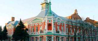
The following have been preserved: the complex of the Nizhneturinsky ironworks (workshops of the late 18th–19th centuries, a dam), a 2-story building with a 4-column dorich. portico of the factory administration building (1829, architect A.Z. Komarov; now the city court); classic ensemble of 7 residential and administrative buildings. buildings of the Nikolaev arms factory (1852–62); brick building of the zemstvo school (beginning of the 20th century), merchant houses of the beginning. 20th century Brick c. St. John, Met. Tobolsky (2000–12, on the site of the Trekhsvyatitelskaya Church 1814–24, demolished around 1940). Monuments: to the fallen fighters for the revolution (1920s), the Star monument (1930s, on the site of the demolished chapel of Saints Peter and Paul in 1859), metallurgists who died during the Great. Otech. war. Branch of the Udmurt State un-ta. Museums: historical (1965; branch of the Sverdlovsk Regional Museum of Local Lore), geological. In the mountains feature - natural-archaeological. monument Mount Shaitan.
Leading enterprises: electrical equipment plant NTEAZ-Electric (part of the High-Voltage Union concern; high-voltage products, including vacuum circuit breakers, switchgear, transformer substations), machine building. "Venta" plant (as part of the "Atomenergomash" company; equipment for nuclear power plants, oil and gas industry and other industries; large-scale production of industrial ventilation and heating equipment; at the plant there is a museum of the history of the enterprise), mineral wool products plant " TIZOL" (non-flammable heat and sound insulating materials; there is a museum at the plant). Nizhneturinskaya State District Power Plant (built in 1945–50; branch of the TGC-9 company; capacity approx. 300 MW).
In the vicinity of N.T. there are several. main gas pipelines, including Urengoy - Medvezhye - Nizhnyaya Tura - Yekaterinburg - Chelyabinsk (a large gas compressor station Nizhneturinskaya operates), the Surgut - Polotsk oil pipeline (Belarus) (oil pumping stations Platina, Arbatskaya).
Famous people from Nizhny Turin
Lived and worked in Nizhnyaya Tura
- Pyotr Yakir, a famous dissident, served a prison sentence in the Nizhneturinsk industrial colony in 1938.
- Evgeniy Paperny is an actor at the Kyiv Russian Drama Theater. Lesya Ukrainka, professor at the State University of Culture, People's Artist of Ukraine.
Born in Nizhnyaya Tura
Nizhnyaya Tura
(Sverdlovsk region)
OKATO code:
65478
Founded:
1754
Urban settlement since:
1929
City since:
1949 City of regional subordination
Telephone code (reference phone)
| 34342***** | 21-1-11 |
Deviation from Moscow time, hours:
2
Geographic latitude:
58°37′
Geographic longitude:
59°51′
Altitude above sea level, meters:
205 Sunrise and sunset times of the Sun and Moon in the city of Nizhnyaya Tura
Transport
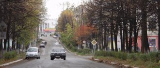
The Yekaterinburg - Serov - Bauxites railway has a branch at the Vyya junction station and goes through the GRES and Mir railway stations to the Nizhnyaya Tura railway station. Lenin Street leads to the central watchhouse (checkpoint) of the closed city of Lesnoy. 40 km to the north-northwest is the city of Kachkanar, 60-70 km to the north are the cities of Novaya Lyalya and Verkhoturye, 40 km to the south are the cities of Krasnouralsk and Verkhnyaya Tura. The Europe-Asia border is located 80 km along the Nizhnyaya Tura - Kosya - Teplaya Gora road (Perm Territory). Highways connecting settlements of managed administrative territories and neighboring cities have asphalt pavement. The road from the Yekaterinburg-Serov highway junction for 220 km is made to bypass the city, heading towards the city of Kachkanar and the village. Is. There are regular bus and train connections between Nizhnyaya Tura and Yekaterinburg, settlements of the Nizhneturinsky urban district, and cities of the Sverdlovsk region.
How to get there?
Coordinates for GPS navigator
58.631082, 59.852340
Nizhnyaya Tura on the map
Interesting on the topic
Soviet canteen-museum on the Yekaterinburg–Serov highway: interior, menu, coordinates
Olga Guryevskikh is a pioneer of interesting Ural locations. Previously, she talked about the seven-colored lakes near Bogdanovich, and today she shares a new find... Find out more
We invite you to an excursion: “Industrial stories of the northern region.”
We invite you to visit the Nizhneturinsky urban district. It is located 220 km from Yekaterinburg. The natural and industrial attractions of this area will be remembered by guests… Read more
Summer camp with children on the banks of the Tura River
On July 6-7, 2022, the second session of our Summer Camp for children and adults took place (what is it and why are we doing it... Find out more
Nizhneturinsky pond - beautiful and diverse
On the weekend of June 14-16, 2022, the first trial session of the Summer Camp took place - our new format of weekend trips, when ... Find out more
Neighborhoods of Nizhnyaya Tura: waterfall on Kosaya Rechka
This time, dear readers, I want to tell you about one very exciting walk that my wife and I took several ... Read more
Neighborhoods of Nizhnyaya Tura: a walk in the forest park
The very end of September... The rowan beauties, like mischievous village girls, dress up in bright sundresses, hoping to attract the attention of the visiting wind, generously, like a merchant, ... Find out more
Yolkino village and its surroundings: weekend route
The first Sunday in March turned out to be unusually warm and sunny. The heady spring air seethed and bubbled, like young, sparkling wine, until ... Read more
Geographical information
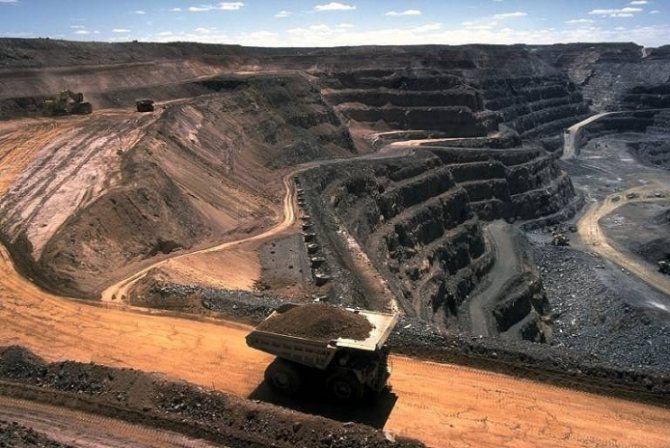
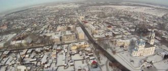
The city is located on the eastern slope of the Ural Mountains in the northern part of the Middle Urals. The main water artery of the Nizhneturinsky urban district is the Tura River with a city pond and tributaries - the Malaya and Bolshaya Imennaya, Is, Nyasma, Talitsa rivers. The territory of the urban district is covered with mixed and deciduous forests, also characterized by a large number of hills and mountains, in particular, Kachkanar (878 m), Saranaya (641.1 m), Shaitan (331.7 m), Beryozovy Uval, Krasnaya Gorka, Petrovskaya, Kolpakovsky Stone, Tent, Deciduous. At the tops there are alpine meadows and subalpine meadows, below there are coniferous forests, at the foot there are arid deserts. On the territory of the Nizhneturinsky urban district there are five environmental zones: Mount Shaitan; limestone rocks near the village. Elkino, Shumikha swamp, Verkhne-Isovsky cedar forest. Minerals: gold, platinum, iron-vanadium ores, brick clay, marble, sand, mercury-containing ore, small deposits of bauxite, brown coal.
The city's attractions
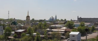
Mount Shaitan
The mountain is located in the center of Nizhnyaya Tura and is not only a natural, but also a historical landmark. The mountain is relatively low - only about 320 meters above sea level. its name - Shaitan or "Evil Spirit" - most likely in connection with the pagan Mansi rituals carried out on it. Today, Shaitan Mountain is included in the register of natural and archaeological monuments of regional significance. From time to time, city industrial mountaineering competitions are held on the mountain.
Author of the photo: Sergey Komkov
In general, there are quite a lot of natural attractions in the vicinity of Nizhnyaya Tura . You can read about them in our articles “Environments of Nizhnyaya Tura: a walk in the forest park” and “Environments of Nizhnyaya Tura: waterfall on the Kosaya River” .
Nizhneturinsky pond
Author of the photo: Ivan Zhikharev
The pond was formed in 1763, and in 1951 a complete reconstruction of various structures, including the dam, began. Children's camps and recreation centers are located on the shore of the pond. In addition, the pond is quite popular among local fishermen - there are about 14 species of fish.
The average depth of the Nizhneturinsky pond is 3 meters, and the total area is 9.8 square kilometers.
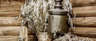
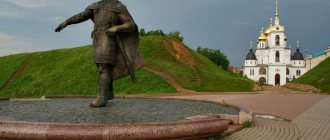
Monument “Samovar – the soul of the home”
Photo source: MBUK “Centralized Library System”
The monument was erected in 2014 on the initiative of Duma deputy NTGO Andrei Postovalov , a famous collector of antique samovars and tea utensils. The opening of the monument was timed to coincide with the 260th anniversary of the city of Nizhnyaya Tura . The samovar is intended to symbolize Russian hospitality. You can find the samovar at the address: Nizhnyaya Tura, Usoshina Street 4.
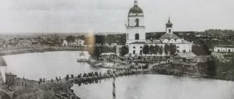
Ironworks complex
Panorama of the Nizhneturinsky plant at the beginning of the 20th century.
Photo by N.F. Lagunov The former ironworks is a monument of industrial architecture of the 18th-20th centuries. On its territory there are still preserved workshops from the end of the 18th century, as well as examples of industrial construction. One such example is a blast furnace built in 1895.
Now the premises of the ironworks are the Nizhneturinsk Electrical Apparatus Plant . Complex address: Nizhnyaya Tura, Zavodskaya street 6A.
Monuments
Also on the territory of Nizhnyaya Tura there are quite a lot of monuments and landmarks. Among them is a memorial to the Nizhny Turin residents who died during the Great Patriotic War , a monument in memory of Yakov Sverdlov , and a memorial sign at the burial site of Hungarian prisoners of war.
Photo by: Patokina Kristina Andreevna
One of the most recognizable monuments is the Order of Glory monument , made in the form of this very order. It is located on Shaitan Mountain on May 8, 1975, in honor of 27 residents of Nizhny Turinsk, who during the Great Patriotic War were awarded the Order of Glory for courage and courage in battle.
Author: Vyacheslav Bukharov - own work, CC BY-SA 4.0, Link
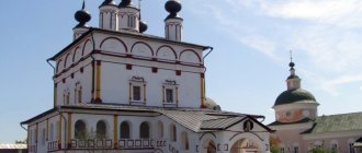
Nizhneturinsk Museum of Local Lore
Author: Sergey Kuvaev - own work, CC BY-SA 4.0, Link
Nizhneturinsk Museum of Local Lore was founded on October 31, 1965 as a folk museum. The museum is located in the historical part of the city in the building of the former plant administration of the Nizhneturinsk ironworks . The museum has a rich exhibition on the history of Nizhnyaya Tura and the region , a paleontological collection formed on the basis of finds on the territory of the Nizhny Turinsky region . A large exhibition is dedicated to the history of gold mining at the Isovsky mines , the construction and operation of an ironworks. Sections of the exhibition on the history of the arms factory and the Nikolaev correctional prison department are of interest.
Nizhneturinsk Museum of Local Lore
Address: Nizhnyaya Tura, Sovetskaya street 2 Phone: +7 (34342) 2-57-81 Social networks: Odnoklassniki, VKontakte
Map
| Nizhnyaya Tura: maps |
Nizhnyaya Tura: photo from space (Google Maps) Nizhnyaya Tura: photo from space (Microsoft Virtual Earth)
| Nizhnyaya Tura. Nearest cities. Distances in km. on the map (in brackets along roads) + direction. Using the hyperlink in the distance , you can get the route (information courtesy of the AutoTransInfo website) | |||
| 1 | Forest | 3 (1) | NW |
| 2 | Kachkanar | 23 (27) | NW |
| 3 | Verkhnyaya Tura | 27 (30) | YU |
| 4 | Krasnouralsk | 31 (36) | YU |
| 5 | Kushva | 37 (38) | YU |
| 6 | Baranchinsky | 50 (52) | YU |
| 7 | Gornouralsky | 60 () | YU |
| 8 | Verkhoturye | 61 (127) | NE |
| 9 | New Lyalya | 64 (85) | NE |
| 10 | Free | 71 (115) | SE |
| 11 | Lobva | 72 (101) | NE |
| 12 | Verkhnyaya Salda | 75 (126) | SE |
| 13 | Nizhnyaya Salda | 77 (139) | SE |
| 14 | Nizhny Tagil | 78 (84) | YU |
| 15 | Nikolo-Pavlovskoe | 92 () | YU |
| 16 | Gornozavodsk | 92 (126) | Z |
| 17 | Makhnevo | 109 () | IN |
| 18 | Serov | 116 (146) | WITH |
| 19 | Gremyachinsk | 116 (174) | Z |
a brief description of
Located on the eastern outskirts of the Middle Urals, on the river. Tura (Ob basin), 254 km north of Yekaterinburg. Railway station.
Territory (sq. km): 1940
Information about the city of Nizhnyaya Tura on the Russian Wikipedia site
Historical sketch
It emerged as a settlement during the construction of the Nizhneturinsky state-owned ironworks in 1754. In 1766, the plant produced its first products. In 1824, in the territory of the Nizhneturinsky volost, on the rivers Is, Vyya and Tura, placer deposits of gold and platinum were discovered (Isovsky mines provided over 50% of gold and platinum production in the Urals).
In 1852-62. The Nizhneturinsky Nikolaev arms factory operated (produced shells, bullets, ignition tubes for guns), which in 1889-93. was converted into a prison for political prisoners - the Nizhneturinsky Nikolaevsky correctional prison department, known as the “Ural Shlisselburg”. Ya.M. served his exile here. Sverdlov, I.M. Malyshev, F.A. Sergeev (Artyom), etc.
In 1925, after reconstruction, a metallurgical plant (formerly an ironworks) came into operation.
Since February 25, 1929, the working settlement of Nizhnyaya Tura. From 03/09/1949 the city. Name by location on the river. Tura; The definition lower indicates the presence of the city of Verkhnyaya Tura upstream.
Economy
Nizhnyaya Tura is the organizational and economic center of a large mining region.
Plants: machine-building (1957-58), electrical equipment (1958, based on metallurgical), mineral wool (1949). Food industry enterprises (sausage factory, bakery). Production of building materials. Forestry
Nizhneturinskaya State District Power Plant (first current in 1950).
In the Nizhnyaya Tura area there are mining villages.
Main enterprises
BUILDING MATERIALS INDUSTRY
OJSC "Tizol"
624350, Sverdlovsk region, Nizhnyaya Tura, st.
Malysheva, 59 Offers:
Mineral wool thermal insulation materials
Culture, science, education
Museum of Local Lore.
Universities of the city
Udmurt State University (Nizhny Turinsky branch)
624221, Sverdlovsk region, Nizhnyaya Tura, st. Nagornaya, 19
Architecture, sights
The city is characterized by rugged terrain. In the center of the city is Mount Shaitan. The center of Nizhnyaya Tura is a picturesque area around the factory pond. In the western and eastern regions of the city, wooden manor buildings predominate; in the southwest of the city (the village of the machine-building plant) - multi-storey buildings.
| Population by year (thousands of inhabitants) | |||||||
| 1931 | 4.8 | 1996 | 26.5 | 2008 | 22.8 | 2017 | 20.2 |
| 1939 | 5.4 | 1998 | 26.5 | 2010 | 22.3 | 2018 | 19.9 |
| 1959 | 20.6 | 2000 | 26.3 | 2011 | 22.0 | 2019 | 19.5 |
| 1967 | 22 | 2001 | 26.0 | 2012 | 21.6 | 2020 | 19.4 |
| 1970 | 19.6 | 2003 | 24.2 | 2013 | 21.5 | 2021 | 19.1 |
| 1979 | 22.9 | 2005 | 23.7 | 2014 | 21.1 | ||
| 1989 | 26.3 | 2006 | 23.3 | 2015 | 20.8 | ||
| 1992 | 26.8 | 2007 | 22.9 | 2016 | 20.5 | ||