For other places with the same name, see Uvarovo.
City in Tambov region, Russia
| Uvarovo Uvarovo | |
| City [1] | |
| Flag Coat of arms | |
| Location of Uvarovo | |
| Uvarovo Location of Uvarovo Show map of Russia Uvarovo Uvarovo (Tambov region) Show map of Tambov Oblast | |
| Coordinates: 51°59'N 42°16'E / 51.983°N 42.267°E / 51.983; 42.267 Coordinates: 51°59'N 42°16'E. / 51.983°N 42.267°E / 51.983; 42.267 | |
| A country | Russia |
| Federal subject | Tambov region [1] |
| Based | 1699 |
| City status from | 1966 |
| Height | 140 m (460 ft) |
| population size (2010 Census) [2] | |
| • General | 26 830 |
| • Evaluate (2018) [3] | 23 987 ( -10,6% ) |
| Administrative status | |
| • Subordinate | city of regional significance Uvarovo [1] |
| • Capital from | Uvarovsky district [1], city of regional significance Uvarovo [1] |
| Municipal status | |
| • Urban district | Uvarovo urban district [4] |
| • Capital from | Uvarovsky urban district [4], Uvarovsky municipal district [4] |
| Timezone | UTC+3 (MSK[5]) |
| Postal code [6] | 393460–393464 |
| OKTMO ID | 68730000001 |
Uvarovo
(Russian: Uvarovo) is a city in Tambov Oblast, Russia, located on the right bank of the Vorona River (Don's basin), 117 km (73 mi) southeast of Tambov. Population: 26,830 (2010 census); [2] 29,690 (2002 census); [7] 34,554 (1989 census). [8]
LOCAL HISTORY. 1969. The city of Uvarovo. (FROM UVAROV’S PAST). A.I. Akindinov, M.K. Snytko
At this time, the population of the region increases significantly. “Utekletsy” and “wanderers” from the central regions of Russia, alone and in groups, populated the right bank of the Vorona. They are on their own (farm plots). Odnodvortsy built dugouts. They were engaged in hunting animals and birds, fishing and beekeeping (collecting honey from wild bees). Already in the 17th century, the tsarist authorities began to distribute lands near Vorona to service people and boyars. As documents from 1699 testify, lands in the tracts on the Vorona River were granted to the regimental Cossacks Moisey Alekseev and Kondraty Emelyanov with their families and relatives. Alekseev and Emelyanov managed to raise their relatives (30 yards) to a new place. The Cossacks settled in the forest, near the Vorona River. In the same place, Pyotr Spiridonovich Uvarov lived his trade, after whom the settlement is named. The location chosen was convenient. The forest provided building material, fuel, mushrooms, served as a place for hunting and sheltered from enemies. The river provided fish and was a cheap means of communication. Down it one could go down to the Khopr and Don. Up the Vorona, across the Kashma River, they crossed to Tsna.
Old-timers and documents confirm that the first settlement was located in the area of the current Krasnaya Zarya and Michurin streets. In 1702, a wooden church was built here and the village of Uvarovo was renamed a village.
At the beginning of the 18th century, the borders of the Russian state advanced far to the south, beyond the Chernozem region, and the raids of the Crimean Tatars and Nagais stopped. Favorable conditions were created for settlement and widespread economic development of the southern territories of the Tambov Territory. At this time, huge tracts of fertile land were distributed to noble nobles and royal officials. The feudal system of economy is being established in the region.
In 1779, according to a new administrative reform, Uvarovo belonged to the Borisoglebsk district of the Tambov province. The Borisoglebsk-Kirsanov highway was built through the village.
With the construction of dirt roads and the development of waterways, trade relations are expanding
between individual parts of the Tambov region. The village of Morsha in the north and the city of Borisoglebsk in the south became important centers of trade and transport operations at this time, where bread, wool, honey and other products were sent from Uvarov with subsequent rafting to Moscow, St. Petersburg or the Don. In the first half of the 19th century, due to the further development of the national market, the demand for bread and other agricultural products from developing industrial centers - Moscow, cities of the Moscow region, St. Petersburg and others - increased. This causes an increase in the production of agricultural products in the provinces of the Black Earth Region, which continued to be the breadbasket of Russia.
On the farms of landowners, measures are being taken to increase the production of grain and livestock products, and the exploitation of serfs and state peasants is intensifying.
Uvarovo during this period was a typical agricultural settlement in the Tambov region. Its residents were forced to sell their meager grain reserves and go to work for the landowners to pay unaffordable taxes.
The population of Uvarov lived poorly. Wooden huts, covered with straw, or even just dugouts, were heated in black. All the decoration consisted of a table, three or four benches and a loom, all made by hand. Residents wore homespun clothes and ate sparingly. The illiteracy and darkness of the overwhelming majority of the population created conditions for the emergence of religious sects in the village (Molokans, Khlysty, Baptists). As statistics show, in 1840 in Uvarovo there were 249 households of state peasants and 2,572 people lived. Its trade connections expanded. In the center of the village, a stone church was built at the expense of the population, shops and taverns were opened, and storehouses were built. Once a week there was a market. As Tambovskie Vedomosti reported, on March 17, 1840, the first fair took place in Uvarov. Later, two fairs were held per year. Handicrafts received some development: there were many masons, carpenters, tailors and shoemakers in the village.
The reform of 1801 did not improve the economic situation of the multimillion-dollar Russian peasantry; it was a blatant deception of the peasants. After the reform, the peasants of Uvarov lost a significant part of their land - meadows and pastures.
The development of capitalist relations in agriculture in post-reform times accelerated the social stratification of the population and caused a rapid increase in trade. Commercial capital also grew in Uvarov. It became an important point of grain trade in the southeast of the Tambov province.
In 1862, the village already had 5,546 inhabitants. In terms of population, it took second place in the district after Borisoglebsk, and it was in second place in terms of trade.
Uvarovo housed 25 shops and stores, 10 taverns and other drinking establishments. Local and visiting merchants were engaged in the purchase and resale of livestock, leather, honey, wax, but the basis of the commercial life of the village was the grain trade. Bread came to Uvarovo from landowners and peasant farms in the nearby volosts of Borisoglebsky and Kirsanovsky districts, as well as from Balashovsky and Atkarsky districts of the Saratov province; from here he headed to Yelets, Kozlov, Morshansk, Tambov and further to Moscow. Carts with rye, wheat, peas and flaxseed stretched along all the roads. In the summer, part of the grain was sent to Borisoglebsk, from where it was rafted along the Vorona and Khopru to the Don.
With the growth of grain trade, grain processing enterprises are expanding and new industries are emerging. A large mechanical roller mill, a starch mill, a potash mill, a lard mill, a wax mill, a tannery, two soap factories, a match factory and other enterprises are being built in Uvarov. According to the 1880 census, there were 28 industrial enterprises operating in the village, employing about 500 workers. Flour-grinding and cereal-making predominated. In 1893, the Tambov-Kamyshin railway passed near the village, which brought significant changes to its economic life. At that time, the Uvarovo station, later Oblovka (so named after the engineer who built the road), was considered large. It shipped up to three million pounds of various cargo, more than half of which was grain, flour and cereals. The station had an elevator, granary and storage barns.
In connection with the construction of the railway, the grain trade area changed somewhat. The supply of grain from the Saratov province stopped, but its flow from villages located along the Borisoglebsk-Kirsanovsky tract increased.
The purchase of bread in Uvarovo and its environs is taken over by the Russian-Asian Commercial and Industrial Bank, which opened a branch at the station with <...>.
In 1899, Uvarovo became the center of the Uvarov volost. The bulk of the population, which by this time had reached <...> 10,000 people, were peasants - poor and middle peasants, there were few workers and artisans. Kulaks, merchants and owners of industrial enterprises controlled the entire economic life of the village.
In the center of the village, buildings for volost administration, schools, and post offices are being built. The local bourgeoisie, who became rich in the grain trade, erects two-story urban-type mansion houses. The first floor is allocated for a retail establishment or warehouse, the second for residential premises. The village was officially divided into <…> land societies. This was reflected in the development: in the first society there were images <...> of a trade and administrative center with industrial establishments, the second was a typical village with well-developed gardening.
The situation of the working peasantry remained difficult. The process of social stratification intensified. The population increased every year, and land plots decreased. The number of landless and land-poor peasant households grew. As evidenced by the materials of a household survey in the Tambov province (1912), in Uvarov there were about 30% of cowless and more than 38% of horseless peasant households, and taxes increased. In 1897, a major disturbance occurred in Uvarovo during the collection of arrears; the authorities arrested 29 peasants. Next year the peasants rise again. They demand an increase in land plots. Troops were sent to the village to quell the unrest.
Peasant unrest broke out with renewed vigor in 1903-1905. On February 1, 1903, Lenin’s Iskra published a report about searches and arrests of rural teachers in Uvarovo and Shibrey. In February 1905, teacher P.F. Uvarov and doctor S.M. Rubinovich were arrested for anti-government speeches. In the autumn of the same year, mass unrest of peasants began, engulfing Uvarovskaya and neighboring volosts. The match factory workers were the first to speak. At their call, the destruction of the landowners' estates began. The telegram of Lieutenant Shcherbnin, sent from Uvarov to Borisoglebsk on November 1, speaks about how wide the scope of the uprising was: “For 60 miles around Uvarov, estates are being robbed and burned.” Frightened by the revolutionary movement, the authorities declare Uvarovskaya and neighboring volosts under martial law; several punitive detachments are sent here under the command of Vice-Governor Bogdanovich. The unrest did not stop, so until 1907 there was half a company of Cossacks in Uvarovo.
The imperialist war of 1914-1917 further intensified the impoverishment and ruin of the poor and middle peasantry of Uvarov, as well as many thousands of other villages in Russia.
After the fall of the autocracy in Russia in February 1917, a volost zemstvo government was created in Uvarovo. Under the influence of the Social Revolutionaries, entrepreneurs, large merchants, and kulaks are elected to the executive committee of the government. In May, the advanced part of the peasantry, together with the front-line soldiers, organized a rural revolutionary committee, the chairman of which was appointed L. V. Charykov. The Revolutionary Committee directs the performances of workers at industrial enterprises in the village (at the Unkovsky mill, etc.). The peasants of Uvarovskaya and neighboring volosts begin to seize the landowners' estates.
Uvarovo city, Tambov region
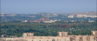
Uvarovo is my hometown. The place where my childhood lives. A “preserved” corner of the Tambov region, whose streets look the same as they did 20 years ago, and time seems to flow more slowly. Therefore, I am especially happy and pleased to show you photos from a short winter walk through the center and outskirts of the city on a sunny day. 1. We left at the Saturday market and headed towards familiar streets. Every house and even every tree is familiar here.
2. Turn onto the secret path - and soon we find ourselves in front of the old bridge, thanks to which residents of Uvarovo 2 can quickly get to the bazaar, supermarkets and pharmacy. In the nineties, the bridge looked quite extreme - the boards could not withstand the load or were poorly secured. Fortunately, they have been monitored more closely in recent years. However, the descent is still steep.
3. View from the bridge.
4. We admired, reminisced and returned to Peter Shiryaev Street. Here we came across an original example of a snowman with a full set of necessary attributes - a hat with ear flaps, a broom and a bottle of vodka (empty).
5. Another greeting from childhood - an old house. For at least 7 years I walked past it from my grandmother to school and back. Only before there was life in it, but now there are no traces of its presence.
6. The building of the former Mir cinema now belongs to the Uvarov diocese. After the collapse of the USSR, the cinema quickly fell into disrepair, the premises were empty. The building was recently renovated, plastered and painted green. By the way, for some reason shades of green are very popular - this will be noticeable in other photographs.
7. On the territory of the Nativity of Christ Cathedral.
8. Church of the Nativity of Christ, the opening of which dates back to 1840. They built it at the expense of parishioners - there were 704 courtyards. In 1937, the temple was closed and began to function again only in 1994, after restoration.
9. Exit from a small park located between administrative buildings.
10. Once - School No. 3, then - the House of Pioneers, now - “Children’s educational and health center.
11. In my memory it looked like class=”aligncenter” width=”1024″ height=”768″[/img]
12. And now - a surprise. Yes, you didn't think so. This is a real castle, standing on a par with modest one-story houses. The massive gate is already ready, we are waiting for the appearance of a moat with crocodiles.
13. We returned to the park. The Administration of the city of Uvarovo, Tambov region, is visible ahead.
14. The main Christmas tree of the city on Lenin Square. Yes, look closely, it points to a bright future.
15. Let’s listen to grandfather Lenin and go there - towards the “komkhoz” and the river.
16. Wow, beauty!
17. Below is a street with mostly abandoned houses. But we weren’t able to really see it, because a pack of dogs, delighted at the proximity of the prey, moved towards us... And it was time to return.
Share link:
- Click to share on Twitter (Opens in new window)
- Click here to share content on Facebook. (Opens in a new window)
Map
| Uvarovo: maps |
Uvarovo: photo from space (Google Maps) Uvarovo: photo from space (Microsoft Virtual Earth)
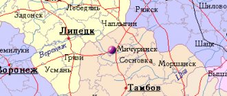
| Uvarovo. Nearest cities. Distances in km. on the map (in brackets along roads) + direction. Using the hyperlink in the distance , you can get the route (information courtesy of the AutoTransInfo website) | |||
| 1 | Muchkapsky | 20 (44) | SE |
| 2 | Rzhaksa | 24 (23) | NW |
| 3 | Inzhavino | 39 (49) | WITH |
| 4 | Romanovka (Saratov region) | 42 (199) | SE |
| 5 | Ternovka (Voronezh region) | 56 (111) | SW |
| 6 | Zherdevka | 57 (90) | Z |
| 7 | Satinka | 59 (75) | NW |
| 8 | Gribanovsky (Voronezh region) | 62 (90) | YU |
| 9 | Turks (Saratov region) | 69 (241) | IN |
| 10 | Borisoglebsk | 69 (77) | YU |
| 11 | Znamenka | 74 (98) | NW |
| 12 | Tokarevka | 75 (90) | Z |
| 13 | Balashov | 78 (162) | SE |
| 14 | Will clean | 80 (120) | NE |
| 15 | Rasskazovo | 80 (79) | WITH |
| 16 | Kirsanov | 80 (98) | NE |
| 17 | Sands (Voronezh region) | 82 (123) | YU |
| 18 | Kotovsk | 84 (113) | NW |
| 19 | Arkadak | 84 (214) | IN |
| 20 | Povorino | 87 (105) | YU |
| 21 | Novaya Lyada | 90 (95) | NW |
| 22 | Tamala (Penza region) | 91 (139) | NE |
| 23 | Builder | 93 () | NW |
| 24 | Pokrovo-Prigorodnoye | 96 () | NW |
| 25 | Tambov | 98 (109) | NW |
| 26 | Ertil | 101 (127) | Z |
| 27 | Mordovo | 103 (125) | Z |
| 28 | Gavrilovka 2nd | 104 (121) | WITH |
| 29 | Rtishchevo | 107 (197) | IN |
| 30 | Bondari | 108 (110) | WITH |
| 31 | Novokhopyorsk | 108 (138) | SW |
a brief description of
The city is located in the southeastern part of the Oka-Don (Tambov) plain, on the right bank of the river. Vorona (Don basin), 117 km southeast of Tambov. Railway Oblovka station. Road junction.
Territory (sq. km): 23
Information about the city of Uvarovo on the Russian Wikipedia site
Historical sketch
In the 14th century The border between the Ryazan principality and the Golden Horde ran along the Vorona River; Russian “guards” were stationed on the right bank of the Vorona.
In 1699, the Cossack settlement of Uvarovo was founded. The regimental Cossacks Moisey Alekseev, Kondraty Emelyanov and their relatives settled here (about 30 households in total). Since 1702, with the construction of a wooden church, the village became a village. Name after the surname Uvarov.
In 1770, the postal route Borisoglebsk - Kirsanov was built through Uvarovo. In the second half of the 19th - early 20th centuries. Uvarovo is a significant center of trade in the county. In 1840, a stone church was built and the first trade fair took place.
At the end of the 19th century. village of Uvarovo, Borisoglebsk district, Tambov region.
In 1893, a railway passed near Uvarovo (the Oblovka station was named after the engineer who built it). In 1899, 10 thousand people lived in the village of Uvarovo.
In the 1959 census data it is mentioned as the village of Uvarovo First. On July 6, 1960, the village of Uvarovo was transformed into the workers' settlement of Uvarovo. City since November 5, 1966
Economy
Factories: chemical (production of double superphosphate), experimental mechanical "Granit" (production of special technological equipment and tooling), sugar, butter, butter, brick.
In the Uvarovsky district, grains, sugar beets, sunflowers, and coriander are grown. Meat and dairy cattle breeding.
Main enterprises
CHEMICAL INDUSTRY
OJSC "Uvarovsky Chemical Plant"
393540, Tambov region, Uvarovo, Molodezhny microdistrict
Offers:
chlorosulfonic acid, ammophos, granulated superphosphate, nitrogen fertilizers
Universities of the city
Moscow Psychological and Social Institute (Uvarovsky branch)
393463, Tambov region, Uvarovo, Molodezhny microdistrict, 6-A
Museums, galleries, exhibition halls
Museum-Estate of S.V. Rachmaninov “Ivanovka” 393481, Tambov region, Uvarovsky district, village Ivanovka Phone(s): 8 915 864 1055 Website: https://ivanovka-museum.ru/
Architecture, sights
Near Uvarovo, in the village of Ivanovka, is the former estate of the Satins, where from the spring of 1890 to April 1917 the composer and pianist S.V. lived and worked. Rachmaninov (now the Rachmaninov Museum).
In the village of Staraya Olshanka there are the remains of the former Voeikov estate, where artists V.D. often visited. Polenov and his sister, decorative artist E.D. Polenova. The Church of the Resurrection (1843-60) has survived.
| Population by year (thousands of inhabitants) | |||||||
| 1939 | 10.8 | 1996 | 34.3 | 2007 | 27.4 | 2015 | 24.8 |
| 1959 | 6.8 | 1998 | 33.4 | 2008 | 27.1 | 2016 | 24.5 |
| 1967 | 16 | 2000 | 32.6 | 2010 | 26.6 | 2017 | 24.2 |
| 1970 | 24.9 | 2001 | 32.2 | 2011 | 26.8 | 2018 | 24.0 |
| 1979 | 31.7 | 2003 | 29.7 | 2012 | 26.1 | 2019 | 23.6 |
| 1989 | 34.6 | 2005 | 28.4 | 2013 | 25.8 | 2020 | 23.1 |
| 1992 | 34.8 | 2006 | 27.9 | 2014 | 25.1 | 2021 | 22.9 |
Coat of arms of Uvarov
The coat of arms was approved by decision of the Uvarovsky City Council of People's Deputies dated November 29, 2012 No. 378 and entered into the State Heraldic Register of the Russian Federation under No. 8060. History of the Uvarovsky Coat of Arms
Today, almost every Uvarov resident knows and is proud that our small town has its own official symbol - the coat of arms. Many can even reproduce from memory what is depicted on it. But few people know the name of the person who created the sketch of the coat of arms. And what meaning is put into everything depicted on this solemn symbol of the city is a mystery to most. And it was like this...
In the mid-nineties of the last century, the city administration received an official letter from Moscow, from the Heraldic Chamber. Its essence boiled down to the following: it is planned to publish a catalog dedicated to the heraldry of Russian cities, and if your city has a coat of arms, then please send its sketch, description, etc. for inclusion in this catalogue. At that time there was no coat of arms...
The main architect of the city at that time was Yuri Ivanovich Sushkov. Of course, the development of projects related to heraldry was not part of his direct job responsibilities. But he himself, as a native Uvarovite, often wondered: really, why doesn’t our city have its own official symbol? And I didn’t just think about it, but already tried to make sketches. One such option already existed by the time that Moscow letter arrived. But he was somehow too “productive”. Of all the symbols depicted on it, only the river was “historical”. The pipe personified the development of production: in those years the chemical plant, in fact, which made our Uvarovo famous for its power and scale, was still alive. And many other enterprises were still operating quite successfully. The third element of the trial version is wood. It, according to the plan of Yu. I. Sushkov, personified the famous Uvarov gardens. But it just so happened that in the imagination of everyone who looked at this coat of arms, it was not a garden that appeared, but a forest. It would also seem to be a symbol of Uvarov... But still, Sushkov didn’t like something, he felt some kind of incompleteness, inaccuracy, “unhistoricalness” or something. This option seemed to him not entirely successful even at the city level, not to mention presenting it to the Heraldic Chamber...
In general, there are certain conditions and procedures for approving symbolism. According to them, a competition was announced at the regional level for the best sketch of the coat of arms, which will subsequently be officially registered. A competition commission was created. Creative work went on for a month. As a result, several applications were submitted. The selection, as expected, was carried out anonymously. As a result, the work of Yuri Sushkov, as it later turned out, won. Only this was a completely different option. By decision of the City Council, the coat of arms was approved as the official heraldic symbol of Uvarov.
What is depicted on the new coat of arms?
While working on it, Yuri Ivanovich took into account all previous mistakes. And the main one was that the coat of arms should still reflect something historical, existing from time immemorial and to this day. And manufacturing enterprises are a fickle “phenomenon”: there is no longer a chemical plant, other enterprises have been given a long life. Ultimately, only the river remained from the previous symbolism. If we look at archival documents, it was precisely this that became the decisive factor in the fact that a settlement arose here at the very end of the 17th - beginning of the 18th centuries. Therefore, this symbol on the coat of arms is quite logical.
Yu. I. Sushkov did not refuse the symbol of the famous Uvarov orchards, the predominant of which were cherry trees. The fact is that Uvarovo has always been characterized by low building density; here and now, as before, one-story houses predominate, each with a plot of land with a garden. In the old days, Uvarov residents exported the harvest to fairs and bazaars, and even today, according to tradition, “caravans” with cherries and currants reach the capital in June-July. Abandoning the schematic tree, Yuri Ivanovich depicted two ripe cherries on green stalks as a symbol of the garden. Later, one berry was removed, and therefore the remaining one seems a little disproportionately large, hypertrophied...
Of the new symbols, three bees appeared on the coat of arms. They personify belonging to the Tambov region: there are also bees on the official coat of arms of our region. But if we think more deeply, beekeeping in former times, and now cultivated beekeeping are inherent in our settlement. Uvarov honey is also known far beyond the Tambov region for its healing and excellent taste.
As you know, the background of the Uvarov coat of arms is yellow. Why? Yuri Ivanovich himself explains it this way: Uvarovo is located in the middle, steppe zone, and according to all the canons of cartography it is customary to mark it in yellow. And from the professional, artistic side, all the attributes of the coat of arms: a red cherry on a green stalk, a blue river, and brown bees - all this looks more contrasting and more advantageous against this background.
This is it, the official heraldic symbol of Uvarov. When they asked its creator if he was proud of his creation, Yuri Ivanovich modestly replied: “No, it doesn’t take your breath away from pride.” It’s nice, of course, to see and realize that this is “your work.” And then, after thinking, he added: “Still, I made a certain contribution to the history of my native Uvarov.”