City in Kaluga region, Russia
| Lyudinovo Lyudinovo | |
| Town[1] | |
| Lake Lompad embankment in Lyudinovo | |
| Flag Coat of arms | |
| Location Lyudinovo | |
| Lyudinovo Location Lyudinovo Show map of Russia Lyudinovo Lyudinovo (Kaluga region) Show map of Kaluga region | |
| Coordinates: 53°52′N 34°26'E / 53.867°N Latitude 34.433°E / 53.867; 34.433Coordinates: 53°52′N 34°26'E / 53.867°N Latitude 34.433°E / 53.867; 34.433 | |
| A country | Russia |
| Federal subject | Kaluga region[1] |
| Administrative region | Lyudinovo district[1] |
| First mention | 1626[2] |
| City status from | 1938 |
| Height | 180 m (590 ft) |
| population (2010 Census)[3] | |
| • General | 40,530 |
| • Evaluate (2018)[4] | 38,267 (-5.6%) |
| Administrative status | |
| • Capital from | Lyudinovo district[1] |
| Municipal status | |
| • Municipal district | Lyudinovo municipal district[5] |
| • Urban village | Lyudinovo village[5] |
| • Capital from | Lyudinovo municipal district[5], urban-type settlement Lyudinovo[5] |
| Timezone | UTC + 3 (MSK [6]) |
| Postal code(s)[7] | 249400–249403, 249405, 249406 |
| OKTMO I WOULD | 29620101001 |
| Web site | Admludinovo.RU |
Lyudinovo population
| 2010 Census | 40,530[3] |
| 2002 Census | 41,829[8] |
| 1989 Census | 43,696[9] |
| 1979 Census | 39,812[10] |
Lyudinovo
(Russian: Lyudinovo) is a town and the administrative center of Lyudinovsky District in Kaluga Oblast, Russia, located on the shore of Lake Lompad formed by a dam on the Nepolot River, 188 km (117 mi) southwest of Kaluga, the administrative center of the region. As of the 2010 Census, its population was 40,530.[3]
Story
The village of Lyudinovo was first mentioned in 1626.[2]
At the beginning of the 18th century, a Russian industrialist from the Urals, Evdokim Demidov, ordered the construction of two dams on the Nepolot River. Two reservoirs have been created: the upper (Lyudinovskoye) and the lower (Sukremlskoye). In 1738, an iron foundry was built near the Sukremlin reservoir. In 1745, an iron foundry was built near the Lyudinovo reservoir. Today the Lyudinovo Locomotive Plant is located here.
Ivan Akimovich Maltsov bought the metallurgical plant from the Demidov family, and his son, Sergei Maltsov, was responsible for developing the area into a center of industrial production. In 1841, the first Russian rails for the Nikolaev Railway were manufactured here. In 1857-1858, these factories produced ships for the Russian Black Sea Fleet and river vessels. The first Russian steamships were built here in 1858.
In 1866-1867, the first Russian open-hearth furnaces were built at the Lyudinovo metallurgical plant.
Russia's first commercial steam locomotive was built here in 1879. The peak of industrial growth occurred in 1875–1885, when the government ordered a batch of locomotives and carriages from local factories.
In 1890-1894, the first steam locomotive plant in Russia was built.
In 1917, Lyudinovo entered the Communist Revolution as a large industrial area. In 1918, all industries were nationalized. In 1922, the locomotive plant resumed production of locomotives and locomotives.
In 1938, the workers' village of Lyudinovo received city status.
The Second World War
During World War II, Lyudinovo was under German occupation from October 4, 1941 to January 9, 1942 and again from January 17, 1942 to September 9, 1943.
During the German Operation Typhoon on October 4, 1941, the entire territory of the Lyudinsky district was occupied. However, three months later it was briefly reoccupied by Soviet troops during Moscow's counter-offensive.[11]
On January 17, 1942, the Germans launched a counterattack. They suddenly attacked the main column of the 1088th Infantry Regiment with aviation and tanks on the march. The Soviet convoy was attacked right on the road, and heavy snowfall made it impossible for truck drivers to maneuver. An uncontrolled retreat began, most of the heavy weapons were lost. At the same time, one of the bombs dropped by the Luftwaffe hit the Soviet headquarters in the city, all communications were disrupted, and most of the Soviet units became uncontrollable. There was no organized defense of the city, only a few villages in the Lyudinovo area were still defended by Soviet troops. On the night of January 17, the last Soviet units abandoned Lyudinovo and retreated several kilometers to the north, where the division commander, Colonel Gartsev, ordered the establishment of a new line of defense.[11]
Throughout the summer of 1942, the Germans tried to advance, but they were unable to break through the Soviet defensive lines. However, all attempts at Soviet counter-offensives also remained ineffective. At the end of July, the 123rd Soviet separate rifle brigade was surrounded at Krutoy and destroyed. Only 53 soldiers and officers passed through German lines. All attempts by Soviet troops to break through the encirclement failed.[11]
The local resistance movement under the command of 16 year old Alexei Semenovich Shumavtsov carried out many successful missions such as blowing up a bridge, a power plant, a fuel depot and many enemy trucks. This movement was called “Lyudinovsky underground. Komsomol group” and consisted of young people. They carried out many reconnaissance missions, collected information about German movements near the front line, their fortifications, ammunition and fuel depots, and sent this information to the partisans and Soviet aviation.[12] In January 1942, Alexey Shumavtsov was ordered to collect information about the German defenses to the north. west of Lyudinovo. His operation was successful, and all information was transferred to the Soviet command.[13] At the end of 1942, a local traitor working with Alexei Shumavtsov at the locomotive plant discovered the group and reported them to the Germans. In October 1942, most of the group members were arrested. During interrogation they were tortured by the Gestapo. The Germans wanted information about the local partisan detachment and their families. All group members were silent. On November 10, 1942, after numerous tortures, they were shot on the outskirts of the city. The fate of the group members after the arrest was unknown until Dmitry Ivanov, a former local resident. Hilfspolizei investigator, was identified and arrested in Paveletsky railway station in Moscow in 1956. He was responsible for the torture and execution of resistance members and civilians. During the investigation, the fate of the group was finally revealed.[14] On October 10, 1957, Shumavtsov and his comrades were posthumously awarded Soviet decorations.
There were also many partisan detachments, the Bytosh partisan brigade and at least six special forces detachments of the NKVD OMSBON, as well as scouts and saboteurs.[11]
On February 23, 1943, the Soviets launched a new offensive. They achieved only limited success.[11]
Throughout the spring and summer of 1943, everything was calm at the front. Only localized clashes occurred in the area.[11]
At the end of August 1943, Soviet troops struck again. The 50th Army advanced from Kirov to the south, the 3rd Army to Lyudinovo and Zhukovka. On September 2, the 17th Rifle Division launched an attack on Lyudinovo. On the morning of September 9, Soviet troops entered the eastern outskirts of Lyudinovo after a chaotic German retreat. Clashes inside the city continued until September 16, when the last German soldiers retreated or surrendered. The next day, September 17, the entire territory of what is now the Kaluga region was liberated.[11]
On February 16, 1944, the State Defense Committee decided to invest huge amounts of money in the Lyudinovo Diesel Locomotive Plant to help its reconstruction.
On June 5, 1944, the Kaluga region was created. This region included Lyudinovsky district.
Post-war history
In 1963, the city was given regional status.
From April 28 to May 2, 1986, the city was hit by a radioactive cloud from Chernobyl. Since December 18, 1997, Lyudinovo has been included in the list of cities affected by the Chernobyl accident. Residents of the city have a privileged socio-economic status.
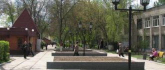
Nature
Lake Lompad, bordered along the banks by coniferous forest, is also called the Lyudinovo Reservoir due to its man-made origin. The Nepolot River originates from the lake. All these waters divide the city in two - into the eastern and western parts. Within the city limits, the width of the lake reaches one and a half kilometers.
Lake Lompad is one of the seven wonders of the Kaluga region[4].
From the west, the Bolva River approaches the city, flowing into the Desna near Bryansk. Almost repeating its bends, and in two places crossing the river, stretches the Vyazma-Kirov-Bryansk railway line passing through Lyudinovo.
The river network is widely developed both throughout the Kaluga region and in the Lyudinovsky district. The Bolva River belongs to the Dnieper basin, the Zhizdra River to the Volga basin. These are one of the largest rivers in the Kaluga region. All of them are characterized by a winding channel, a slight fall, and a slow flow.
On the southern side, the city includes the working village of Sukreml, which has its own Sukreml reservoir, formed by a dam on the river separating it from the water area of the upper lake.
Recommendations
Notes
- ^ a b c d f
State Committee of the Russian Federation on Statistics.
Committee of the Russian Federation for Standardization, Metrology and Certification. No. OK 019-95 January 1, 1997 “All-Russian classifier of objects of administrative-territorial division. Code 29 220”, Ed. changes No. 278 / 2015 dated January 1, 2016. (State Committee of the Russian Federation on Statistics. Committee of the Russian Federation on Standardization, Metrology and Certification. No. OK 019-95 January 1, 1997 Russian Classification of Administrative Objects (OKATO). Code 29 220
As amended by Amendment No. 278/2015 dated January 1, 2016). - ^ a b
“General information” (in Russian). Retrieved November 18, 2022. - ^ a b c
Federal State Statistics Service of Russia (2011).
“All-Russian Population Census 2010. Volume 1" [All-Russian Population Census 2010, vol. 1]. All-Russian Population Census 2010 [All-Russian Population Census 2010]
(in Russian). Federal State Statistics Service. - https://www.gks.ru/free_doc/doc_2018/bul_dr/mun_obr2018.rar; archive date: July 26, 2022; Archive URL: https://web.archive.org/web/20180726010024/https://www.gks.ru/free_doc/doc_2018/bul_dr/mun_obr2018.rar.
- ^ a b c d f
Law No. 354-OZ - "On the calculation of time." Official Internet portal of legal information
(in Russian). June 3, 2011. Retrieved January 19, 2022. - Post office. Information and computing center of OASU RPO. ( Post office
).
Search for postal facilities ( Search for postal facilities
) (in Russian) - Federal State Statistics Service of Russia (May 21, 2004). “The population of Russia, the constituent entities of the Russian Federation as part of federal districts, urban settlements, urban settlements, settlements, settlements of 3 thousand or more people.” [Population of Russia, its federal districts, federal subjects, districts, urban settlements, rural settlements - administrative centers, rural settlements with a population of more than 3000 people] (XLS). All-Russian Population Census of 2002 [All-Russian Population Census of 2002]
(in Russian). - “All-Union Population Census of 1989. The current population of union and autonomous republics, autonomous regions and districts, territories, regions, urban settlements and villages. All-Union Population Census of 1979. National composition of the population by regions of Russia” [All-Union Population Census of 1979. Ethnic composition of the population by regions of Russia] (XLS). All-Union Population Census of 1979 [All-Union Population Census of 1979]
(in Russian).
1979 - via Demoscope weekly
(website of the Institute of Demography of the State University - Higher School of Economics. - ^ a b c d f g gram
https://www.vest-news.ru/article/53219 - https://www.molodguard.ru/heroes67.htm
- https://molodguard.ru/heroes65.htm
- https://molodguard.ru/heroes376.htm
Sources
- Legislative Assembly of the Kaluga Region. Law No. 354-OZ of October 4, 2004 “On establishing the boundaries of municipalities, the territory of administrative-territorial units Baryatinsky district”, “Kuibyshevsky district”, “Lyudinovsky district”, “Meshchovsky district”, “Spas-Demensky district”, “ Ulyanovsk district" and granting them the status of an urban settlement, a rural settlement, a municipal district", ed. Law No. 694-OZ of February 27, 2015 “On Amendments to the Law of the Kaluga Region” On establishing the boundaries of municipalities in the territory of the administrative-territorial units “Baryatinsky District”, “Kuibyshevsky District”, “Lyudinovsky District”, “Meshchovsky District” ", "Spas-Demensky district", "Ulyanovsky district" and giving them the status of an urban settlement, rural settlement, municipal district." Came into force after the entry into force of the Law of the Kaluga Region “On changing the status of settlements, territories on the territory of the administrative-territorial units “Baryatinsky District”, “Kuibyshevsky District”, “Lyudinovsky District”, “Meshchovsky District”, “Spas-Demensky District”, Ulyanovsk district, Kaluga region, but not earlier than ten days after the official publication. Published: “Vest”, No. 229–300, October 9, 2004 (Legislative Assembly of the Kaluga Region. Law of October 4, 2004 No. 354-OZ. On establishing the boundaries of municipalities located on the territory of the administrative-territorial units “Baryatinsky District ”, “Kuibyshevsky district”, “Lyudinovsky district”, “Meshchovsky district”, “Spas-Demensky district”, “Ulyanovsky district”, as well as on assigning them the status of an urban settlement, rural settlement, municipal district
As amended by the Law dated 02.27.2015 No. 694-OZ.
On amendments to the Law of the Kaluga Region “On establishing the boundaries of municipalities located on the territory of the administrative-territorial units “Baryatinsky District”, “Kuibyshevsky District”, “Lyudinovsky District”, “Meshchovsky District”, “Spas-Demensky” district", "Ulyanovsk district" and on assigning them the status of an urban settlement, rural settlement, municipal district"
. Comes into force after the Law of the Kaluga Region "On changing the status of settlements located on the territory of the administrative-territorial units "Baryatinsky district", "Kuibyshevsky district", "Lyudinovsky district", "Meshchovsky district", "Spas"-Demensky district", "Ulyanovsky district" of the Kaluga region" comes into force, but not earlier than ten days from the date of official publication.).
Lyudinovo
(Kaluga region)
OKATO code:
29220501
Founded:
1626
Urban settlement since:
1925
City since:
1938 City of district subordination (Lyudinovsky district, Kaluga region)
Center:
Lyudinovsky district
The city was formerly called:
| Lyudinovo plant | ser. 19th century | 1920s |
| Telephone code (reference phone) | |
| 48444***** | 22-2-22 |
Deviation from Moscow time, hours:
0
Geographic latitude:
53°52′
Geographic longitude:
34°27′
Altitude above sea level, meters:
180 Sunrise and sunset times in the city of Lyudinovo
Economy
Main industries: ferrous metallurgy (JSC "Krontif"), mechanical engineering (factories: diesel locomotive, aggregate (hydraulic and pneumatic equipment), mechanical engineering (machine tools, automated lines, hydraulic lifts), cable production (Lyudinovokabel plant)). . Factories: clothing, plastics. Food industry enterprises, timber industry enterprises. Deposits of ceramic clays, sands, and phosphorites have been discovered in the area.
- Aggregate plant
- — not working since mid-2014
- Lespromkhoz
- Machine-building plant
- Food industry enterprises
- Diesel Locomotive Plant – STM Group – Sinara
- Iron foundry
- Garment factory
- HozMart
- "Agro-Invest" - Greenhouse complex
Russian Prime Minister Dmitry Medvedev created a special industrial zone in Lyudinovo. He signed the corresponding resolution on December 31, 2012. According to it, the authorized capital of the special economic zone of industrial production type “Lyudinovo” will amount to 2.6 billion rubles[20].
Culture
Local attractions: Church of St. Sergius of Radonezh (late 19th century), bell tower of the Trinity Church (1836), Church of Paraskeva Pyatnitsa (mid-19th century).
Institutions of additional education
Children's art school
- 259 students in 8 specialties, graduates - 39 people. in year
Children's music school
- 360 students in 11 specialties, graduates - 53 people. in year
Children's art school
- 175 students in 6 specialties, graduates - 36 people. in year
2 branches of a children's music school in the village of Voylovo and a children's art school in the village. Zarechny
Cultural institutions of the city and region
Palace of Culture named after. Gogiberidze:
- number of amateur groups - 38,
- number of participants - 488 people.
District House of Culture
16 rural club institutions:
- 2200 seats,
- number of amateur art groups - 125,
- number of amateur performance participants - 1642 people.
Library system:
- 239 thousand copies, over 15.3 thousand readers
MU "Kinovideocenter":
- 9 film installations
Museum of Labor Glory:
- over 1.5 thousand visits per year
Temples Lyudinovo
- Temple of St. Sergius of Radonezh
- Temple in honor of the Holy Righteous Lazarus, Bishop of Kitia
- Temple of the Kazan Icon of the Mother of God
Links
Settlements on Bolva (from source to mouth) Kaluga region Bolva |
Spas-Demensk
|
Novoaleksandrovsky
|
Verhulichi
|
Nagornoye
|
left tributary Kovylinka | left tributary Degna | left tributary Shrink | right tributary Pesochnya | Kirov
|
Pogost
|
Manino
|
right tributary Kolchinka | Lyudinovo
| left tributary Nepolot | Sukreml |Bryansk region right tributary Vereshchevka | Dyatkovo |
Lubokhna | Fokino
|
Šibenec | Raditsa-Krylovka | left tributary of the Raditz | Bryansk
(
Bezhitsa
)see further: Desna
People associated with the city
- Kireev, Grigory Petrovich
- Merenishchev, Nikolai Vladimirovich
- Savchenkov, Sergey Viktorovich
- Sveshnikov, Dmitry Konstantinovich
Heroes of the Soviet Union
- Visyashchev, Alexander Ivanovich
- Shumavtsov, Alexey Semenovich
- Svertilov, Alexey Ivanovich
- Vitin, Vladimir Karpovich
- Loktionov, Afanasy Ivanovich
- Chugunov, Ivan Yakovlevich
- Mitrokhov, Vasily Kuzmich
- Ignatkin, Fedor Semyonovich
- Utin, Alexander Vasilievich
- Volkov, Semyon Mikhailovich
- Belov, Alexey Ivanovich
Natural resources
The area of the Lyudinovsky district is 930 km², the territory of which is located in the center of the East European Plain, in the southwest of the Central Economic Region of the Non-Black Earth Zone of the Russian Federation. The territory lies on the ancient Precambrian Russian Platform, composed of crystalline rocks; traces of volcanic activity were also found. From above, the crystalline foundation is covered by a thick layer (about 1000 m) of sedimentary deposits of different ages.
There are deposits of ceramic clays, sands, and phosphorites (Slobodo-Kotoretskoye in the Lyudinovsky and Duminichsky districts).
The climate is temperate continental with distinct seasons (warm summers, moderately cold winters with stable snow cover).