Olkhon Island on Lake Baikal is as unique a corner of nature as the deepest lake in the world. This is the largest island on the lake, its length is 73.5 km and its width is up to 15 km.
Since ancient times, it has attracted the attention of people living in those places. According to legend, the great commander Genghis Khan loved to visit Olkhon. Traces of ancient people can still be found on the island. Thanks to numerous legends, Olkhon is considered the sacred center of the northern shamanic world.
Are you going here with children? Our author, who visited both Olkhon and the bays of the Small Sea with his child, wrote where it is better to stay with a child, what to do with him and where to take him.
Geographic coordinates: 53°09′24″ N. w. 107°23′01″ E. d. How to get there: from May to December there is a large landmass to the island and the island is connected by ferry. It follows the Olkhon Gate Strait from Malaya Kurtutskaya Bay to Perevoznaya Bay (current schedule). In addition, you can travel by boat from Irkutsk (at the same time, take a walk around the city, there are a lot of interesting things there).
Cost of travel: transportation of private cars with passengers is free. One way bus from Irkutsk – 1000 rubles per person. Motor ship from Irkutsk one way – 4000 rubles per person.
When the strait freezes, the route becomes an icy crossing. Communication with land disappears in the period November-January, April-May due to the danger of ice drift or too thin ice.
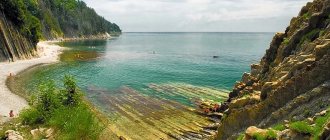
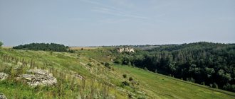
The largest in area of all the lake islands, it separates the Small Sea from the main body of Lake Baikal. The nature of Olkhon is diverse. There are also steppes here (the southern and, partially, the northern coast). The main area of the island is occupied, interspersed, by deciduous and pine forests. In the east there are harsh rocks, near the coast there is great depth. The West is washed by the warm Small Sea. Its gently sloping sandy shores in countless small coves are a pleasant place to sunbathe in summer.
If your trip is not limited to Olkhon, be sure to explore other attractions of Lake Baikal, how best to get to Lake Baikal and our tips for “wild” travelers.
There are several settlements on Olkhon, but only two are suitable for tourists: Kharantsy and Khuzhir . Maly Khuzhir, Usyk, Khadai, Khalgai and Yalga are dying villages. It is worth visiting them only for ethnographic interest.
In Khuzhir, at the weather station there is a rental of tourist equipment, and at the local history museum. Revyakina excursion center operates all year round.
Cape Khoboy
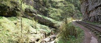
This is the northernmost cape of Olkhon. Tourists come here in winter to approach the rock on the ice. Winter allows you to enter grottoes with huge icicles and splashes of ice. The entrances to the grottoes are on the northern side of the cape.
The caves are dark, so you need to have flashlights when entering them. There are grottoes in the rocks more than 20 m long.
“Khoboy” means “fang” in Buryat. The cape got its name from the similarity of a large columnar rock with a pointed tooth. If you look at the cape from Baikal, you can see a figure reminiscent of a woman’s bust, which is why the cape also has a second name – “Virgin”.
A Buryat legend tells that one young Buryat woman, who was jealous of her husband, was petrified and turned into a rock. And the deities (tengris) to whom she prayed told her: “As long as there is anger and envy on earth, you will remain a stone.”
Local residents considered the cape a sacred place and performed their religious ceremonies on it. Currently, various spiritual practices are practiced here. The cape is popular among representatives of different movements - religious and esoteric.
Only off-road vehicles can drive to Cape Khoboy, as there are shifting sands and steep climbs along the road. It is recommended to hire local drivers - here they not only transport tourists to the cape, but also act as tour guides.
A little about Olkhon Island on Lake Baikal
- The service here is not developed, the cafe does not have a very wide range of menus, so take food with you. And you can count the number of establishments called “cafes” here on one hand.
- It is better to buy fish here on the pier near an abandoned fish factory; as a rule, fresh fish, freshly caught from the waters of Lake Baikal, can only be found here.
Excursions around the Baikal island of Olkhon, usually by water, pick you up at the hotel in a “loaf” (the local name for the UAZ car) and take you straight to the pleasure boat. Without a “loaf” there is nowhere in this area; all the charm, chic and shine of expensive SUVs of visiting tourists here simply pales in comparison with this Russian car, which takes on any obstacle.
- Book a hotel on Olkhon
- Find a plane ticket to Irkutsk
Cape Burkhan and Shamanka Rock
This place is the most popular not only on Olkhon, but throughout Lake Baikal. Since ancient times, Cape Burkhan has been considered a holy place among the inhabitants of the island, and today it is also a natural-historical monument. To be filled with life-giving energy, people from all over the world come to the Shamanka rock.
From Irkutsk to the cape 285 km. You can get here by car - through the villages of Bayandai, Elantsy and Sakhyurta, and then take a ferry to the island.
Cape Burkhan is located near the village of Khuzhir - this is the western coast of Olkhon. From the cape to Khuzhir it is only 600 m. This is the largest settlement on the island - 1,300 people live here. There are hotels for visitors in Khuzhir.
Shamanka Rock is part of the Pribaikalsky National Park. This is a limestone-marble rock, which is easily recognized by its forked top. There is a cave 4 m high running through the rock – this is where shamans once performed their rituals. The cave is revered as a shrine among the Khorin and Barguzin Buryats.
Interesting facts about Shamanka:
- Ancient Tibetan graffiti has been preserved on the walls of the cave.
- At a distance of 150 m from the cave, on a marble rock, tambourines are painted. Scientists date these images to the Neolithic era.
- Shamans claim that tourists disturb the peace of the gods - they litter, write on rocks, make noise.
- The gods, the shamans say, began to take revenge on people. Since 2000, on the road leading from Khuzhir to the cliff, people and livestock are constantly dying, cars are falling down. UFO scientists believe that Cape Burkhan is an anomalous zone.
Alternative ways - how else can you get to Olkhon from Irkutsk
In addition to land wheeled transport, you can get to Olkhon by other means
Plane from Irkutsk and Ulan-Ude to Olkhon Island
Last year, private aviation launched flights between Olkhon Island and Irkutsk and Ulan-Ude.
Flights operate 2 times a week
- The Irkutsk-Khuzhir-Irkuts flight is carried out on Fridays and Sundays, the cost of a ticket from Irkutsk to Olkhon is from 2.5 thousand rubles.
- Flight to Olkhon from Ulan-Ude on Fridays and Sundays - from 2 thousand rubles. one way
The airport (more precisely, a field for landing an airplane) on Olkhon is located near the village of Kharantsy. You can order a transfer from there to Khuzhir (or from Khuzhir) by calling +79086628257 Alexander You can book a ticket by calling in Irkutsk 8 800 234 35 52
Detailed information on the Sila Avia website
Water transport from Irkutsk to Olkhon
By water: Irkutsk - Listvyanka - Olkhon Island (Zagli Bay) - Khuzhir - Irkutsk (excursion)
(Irkutsk - Listvyanka - Olkhon Island (Zagli Bay) - Khuzhir - Irkutsk)
The route is valid from June 11 to August 29
Dates are every FRIDAY and SUNDAY (from June 30 to August 25, additional flight on Wednesdays.)
Travel time 6 hours.
The cost of a boat excursion from Irkutsk to Olkhon (in 2021) is 10,200 rubles. (check and buy on the VSRP website)
other methods
However, for very rich people there is such an opportunity - to go to Olkhon in a private helicopter. This is exactly how the “rich traveler” flew to Olkhon from Irkutsk - Andrei Bednyakov in the program “Heads and Tails” on Lake Baikal.
A private boat will gladly take you to Olkhon from any point of Lake Baikal (Listvyanka, Bolshoi Goloustnoye and even from the Buryat side of Lake Baikal to Olkhon), but it will be expensive. The average cost of a private trip that they told me is 70-80 thousand per boat.
Another alternative to all of the above options could be a taxi (according to the application of the popular taxi “Maxim”, my trip from Irkutsk to Khuzhir was calculated at 5,400 rubles), I don’t think it will be possible to negotiate with private drivers for less money, after all, it’s about 300 km , plus any taxi driver will immediately calculate his way back), but privately it may be possible to negotiate cheaper.
With a private driver through the Bla-bla-Car travel companion search service (it’s not very popular with us yet and there aren’t many trips to Olkhon, but they still happen and that’s good news).
Well, if in the summer you choose these alternative methods or decide to go to Olkhon yourself in your own or rented car, get ready to spend a lot, a lot, and sometimes just a monstrously long time in line for the ferry. Especially if, God forbid, you decide to go there on Friday-Saturday.
In general, I warned you.
In winter you can travel from Listvyanka to Olkhon by Khivus
I recently learned about another exotic and very interesting way to get to Olkhon from Listvyanka - to go there on a khivus directly on the ice of Lake Baikal. There are no “minibuses” here, you can simply negotiate such a trip privately with the drivers of the Khivus buses on the Listvyanka coast.
It’s also better to check the cost with them, but I suspect that it will be quite expensive, since for 15 minutes of “skating on ice in Listvyanka” drivers charge a thousand and a half.
Lake Hankhoy
Lake Khankhoy or Elginskoye is located on the western coast of Olkhon. This reservoir has warm water and a lot of fish - fishermen from all over Siberia come here to fish.
Between Baikal and Khankhoi there is a powerful rocky ridge, climbing which you can admire the picturesque views of the Small Sea, islands, and the Primorsky Range.
Maloe More is a part of Lake Baikal, separated by Olkhon Island. The water area is part of the Pribaikalsky National Park.
Facts about Hanhui Lake:
- lake dimensions – 800 x 500 m;
- Lake Khankhoy is connected to Lake Baikal by a narrow channel - its width is only 2 m and its depth is 30 cm;
- lake depth – 4 m.
There is silt and algae at the bottom of the lake, but the water is still clear. There are 20-30 cm between the algae and the water surface. There are no trees along the shores of the lake, and its western part is swampy.
The lake contains:
- pike;
- stellate sturgeon;
- sorog;
- perch.
There are especially many pikes in the lake. There are specimens reaching 10 kg.
Near the lake you can see:
- archaeological sites;
- ancient burials;
- remains of religious buildings.
Not far from the lake, archaeologists found an ancient ritual complex dating back to the 7th century BC. It consists of over two dozen stone structures.
There are especially many tourists on the lake in July and August. It gets noisy here and people catch fish with nets. Therefore, it is better to come here later - in September, or vice versa earlier - at the end of June, when there are few tourists and fishermen here.
Lake Nuku-Nur
Geographic coordinates: 106°937066 53°04'29" N, 106°56'14" E How to get there: from the village of Khuzhir to the village. Nur and further to the Kobylya Golova (Khorin-Igri) peninsula following the signs.
The lake is located on the Kobylya Golova peninsula, on the western shore of Olkhon Island. It is small in size - 100-150m and has a round shape. Another feature of Nuku-Nur, which distinguishes it from the other lakes of Olkhon, is reflected in its name: it translates as “lake in a hole.” Nuku-Nur fills a depression in the rock, thereby becoming a karst lake. In summer it gets very warm, but you hardly want to go into the water: it is filled with insects and larvae that attract the fish and birds living on the island that live in the reservoir.
Cape Khorin-Irgi
In Buryat, Khorin-Irgi means “mare’s head.” The cape, which gave its name to the entire peninsula, is located in the western part of Olkhon, and if you look at it from the side, you can see the head of a horse floating in the water. On one side the cape is washed by the Maloe More, on the other by the Olkhon Gate Strait.
Cape Khorin-Irgi is separated from the peninsula of the same name by a chasm. Its width is 4 m, and the height of the walls is 10 m. In calm weather, you can go through the crevice in kayaks.
The peninsula is narrow and long. The slopes are rocky and steep. There are several rocky capes, bays and one lake. Many archaeological finds have been found on the peninsula. People appeared in this place about 5 thousand years ago - this is evidenced by numerous artifacts found by archaeologists.
There are several more capes and bays on the Khorin-Irgi Peninsula:
- Cape Halte. Located on the northern coast of the Kobylya Golova Peninsula. Religious buildings from the 17th to 19th centuries were discovered in the rocks. They are stone wells 1.3x1.1 m.
- Cape Tutyrkhey. The eastern cape of the northern coast of Mare's Head. Artifacts dating from the 5th to 10th centuries have been found here.
Lake Nuku-Nur is separated from Lake Baikal by rocks. In fact, this reservoir is located in a rocky funnel. The water in the lake is very warm in summer, but no one swims here - because of the living creatures that infest its bottom.
Since 1981, the Khorin-Irgi Peninsula has been classified as a natural monument of national importance. On the peninsula there is a yurt camp for tourists - “Kochevye”.
Where to live in Khuzhir
Khuzhir is the main tourist village of Olkhon at any time of the year. Most of the island’s population lives here and the entire tourist infrastructure is concentrated - hotels, recreation centers, travel agencies, restaurants and shops.
From the crossing to the village, it’s a 45-kilometer drive on not the best gravel road. If you come to Olkhon without personal transport, then it is best to stay in the vicinity of Khuzhir. There are also several major attractions near the village. And those that are far away can be reached from Khuzhir with an excursion.
UAZ 2206 (popularly “loaf”) is the main car of the island due to its good cross-country ability and ease of maintenance
Hotel.
In summer, a poorly equipped room for two with a shared toilet and washbasins on the street costs from 1000 rubles. For rooms with a private bathroom they ask from 2500 rubles. If the room costs from 3,500 rubles, breakfast is usually included in the price.
In winter there is significantly less housing than in the warm season - all summer unheated options are closed. There are only a dozen hotels to choose from. In February 2022, the most inexpensive room was in the “Pearl of Olkhon” - 1,500 rubles per night for two.
The permanent population of Khuzhir is only about one and a half thousand residents
Among the mid-budget options, there is the Bencharov Estate, a family hotel that the spouses Natalya and Nikita opened 20 years ago. At that time there was not even electricity on Olkhon. Power lines were installed here only in 2005. The Bencharovs have been promoting responsible tourism on the island for many years.
“First, we need to improve the environmental component, and then we can welcome more guests. Everything needs to be done very competently, stage by stage, and the environmental sphere must be ahead of business development. We can receive more guests, but for this we need to work in an environmental direction for several years,” says Bencharov.
In high seasons (June–September, February–March), a double room will cost from 3,600 rubles - an economy option with a shared shower and toilet for two or three rooms. A room with amenities and a view of Lake Baikal costs 7,000 rubles. Places should be reserved several months in advance.
In the luxury segment, the Baikal View hotel stands out—participants of organized luxury tours usually live there, and Andrei Bednyakov stayed there during the filming of “Heads and Tails.” The art residence "Port Olkhon", in addition to stylish rooms and a designer coffee shop, attracts tourists with an unusual art space, which was created as part of festivals held on the territory of the residence.
The interiors of the rooms at the Port Olkhon art residence use natural materials and you feel like you are part of the surrounding wild nature. Photo: booking.com
Tent.
Previously, wild tourists set up tents on Sarai Beach near Khuzhir. But starting from 2022, by decision of the Pribaikalsky National Park, which now includes the Saraisky sandy beach, it was prohibited to put up tents, cars and make fires on its territory.
A list of legal camping sites is listed on the national park website. In addition to purchasing a permit to visit the national park, you also need to pay a fee for setting up a tent - this is 100–200 rubles per night. This price is per tent, not per person. It depends on the camping location: will it be an equipped picnic area, or just a piece of land. You can only find out what kind of campsite you expect - equipped or not - at the stage of obtaining a permit when choosing a place to spend the night.
Cape Khorogoy and Kurykan Wall
Thousands of tourists come to Khorogoy every summer. The cape is located on the northwestern coast of the island - in its middle part. In 1879, the ruins of an ancient wall were discovered here.
Kurykans are a people who lived on Lake Baikal in the 5th-6th centuries. Then all the people disappeared. How and where is unknown. No one even knows what the Kurykans looked like. Scientists suggest that they could have gone north, and the Yakuts are their descendants.
Dimensions of the Kurykan wall:
- wall length – 180 m;
- height – 1.5 m;
- The thickness of the masonry in some places is up to 1.5-2 m.
A one and a half meter wall could hardly have been a reliable defense; most likely, it was much higher, but collapsed over time. The exact purpose of the wall is not known. Perhaps she protected local residents from raids, but this theory has many opponents. Most likely, the wall served as a kind of altar, and the cape itself was considered sacred.
Behind the wall, boulders were discovered in which ancient craftsmen had hollowed out bowls for sacrifices.
At Cape Khorgoy, visitors set up tent camps and swim in well-heated water. Due to the shallow depth, the water here warms up to +22 °C.
Where to stay in Khuzhir on Olkhon and how much does private housing cost?
For a long time on Olkhon it was possible to live only in tents, or you could rent housing in the private sector.
In the summer and now, many people go to Olkhon in tents , and if you like tent romance, then it is quite possible to organize such a budget trip to Olkhon, the main problem will be that there are now too many prohibitions and restrictions from the environmental protection of the Pribaikalsky National Park, which includes Olkhon - to make fires You can’t, you can’t break branches, but this doesn’t really stop camping enthusiasts.
Well, be sure to take warm clothes with you, even in summer, there are huge temperature changes and the strongest low-sea winds on Lake Baikal are sudden and almost unpredictable. So warm yourself up, it definitely won’t be unnecessary, even in July.
It is now also possible to rent private housing on Olkhon per person. During the high season, prices are higher and good places are difficult to find. Therefore, I recommend renting private housing on the website Airbnb.com. Now there are a lot of options for private housing and mini-hotels from private owners for booking.
Just enter “Khuzhir” or “Olkhon” into the search, set your planned dates and book. Just like any hotel on Booking.
- I wrote in a separate article how the Airbnb service works and how to get a $32 bonus for your trip.
Well, for lovers of civilization like me, there are comfortable camp sites and hotels .
Booking.com
Saraisky Bay
The most visited place on Olkhon is Saraisky Bay with the beach of the same name. The length of the sandy beach is 3 km. It is located near the village of Khuzhir. The water here is the warmest on Baikal - it is suitable even for children. Near the water there are small pebbles, but if you go 1 m into the water, there is a sandy bottom that smoothly goes into the depths.
Sarai beach stretches from the village of Kharantsy to Cape Burkhan. The beach is located between sandy hills. There are few trees here, but there are places to rest. There is minimal precipitation here, and summer temperatures can reach +50 °C. Strong winds often blow from Lake Baikal.
There are many beautiful natural places around the beach:
- The beach offers views of the majestic triangular-shaped mountains.
- In the depths of Olkhon there is a large pine forest where you can hide from the sun.
You can pitch tents on the beach. But cars may not be allowed to enter the beach. There is no infrastructure on the beach - people come here to take a break from civilization.
In the 30s and 40s, local forests suffered greatly from deforestation. The remains of the forest are gradually ending up in private hands.
Khuzhir village
After the crossing, everyone usually goes to the main village, which is called Khuzhir. This is the center of the island, both geographically and in all other respects. many housing options in and near Khuzhir from camp sites to private houses and rooms. There you will also find shops and cafes, and you can buy excursions. It is near Khuzhir that there is a stunning sandy beach and the famous Shaman Rock (more on them below).
The village is small - with a population of about 1,500 people. Most locals are employed in the tourism sector, and the tourist flow is only growing every year. Despite this, it is worth taking care of housing in advance because... prices are steep. The cost of living is an order of magnitude higher than on the Small Sea on the mainland. Prices for a comfortable room start from 2500 per night. You can find cheaper accommodation in other places, but a vacation on Olkhon in the summer is simply unthinkable without visiting Khuzhir. All other smaller villages, I list from the crossing:
- Yalga – 23 km
- Maly Khuzhir – 33 km
- Khuzhir – 37 km
- Kharantsy – 43 km
- Khalgai – 51 km
- Peschanaya – 57 km
- Uzury – 80 km
The most interesting are Kharantsy, Peschanaya and Uzury; I’ll tell you more about them below.
Cape Sagan-Khushun
Cape Sagan-Khushun (White Cape) is located in the north-west of Olkhon. On the cape there are steep, sheer white cliffs. Orange-red lichen stands out clearly on the white marble walls. The rocks are especially beautiful in the rays of the setting sun.
“Three Brothers” is the second name of the cape. There are three rocks here, which are lined up one after another. The name of the cape was given by a romantic legend about a girl and her three brothers, who were turned by their father first into eagles and then into rocks.
Sagan-Khushun is located 35 km from Khuzhir. The length of the rock mass is 600 m. All excursion routes to the north of the island pass along the cape. Olkhon. Getting to the cape on your own is not easy - only high-capacity vehicles will pass here. It is best to hire a driver-guide with your own car.
Interesting Facts:
- At Cape Three Brothers, the remains of a ditch and rampart, built in the 5th-10th centuries BC, have been preserved.
- There are many caves in the rocks of the cape. The largest one is in the Middle Brother rock. Its dimensions are 8x4 m. The height of the vault is 3 m. You can swim into this cave by boat.
- The cape has been given the status of a natural monument of regional significance.
Lichens growing on the rocks of the cape are a kind of indicator of air purity. They are very sensitive to pollution. The abundant growth of lichens indicates the pristine purity of Baikal air.
The famous capes of Olkhon and the Small Sea
The magical names Burkhan, Budun, Khorgoy, Khoboy, Sagan-Khushun are the four capes of Olkhon. Each of them has its own characteristics. Thousands of people travel to these natural monuments every year. What attracts them?
Cape Burkhan
How to get there: By car: from Irkutsk to Khuzhir village - 280 km, along the route: Irkutsk - Ust-Ordynsky village - Bayandai village - Elantsy village - MRS ferry crossing - Khuzhir village. Travel time is about 6 hours. By bus: from the Irkutsk bus station to the village of Khuzhir, by regular bus. By boat: from the pier of Irkutsk by regular ships following the routes “Irkutsk-Ust-Barguzin”, “Irkutsk-Severobaikalsk”. Cost: boat ticket – 2200 per person, ferry crossing is free.
The most famous cape of the lake (it is called the symbol of Baikal) is famous for a special rock: it is called Shamanka . This is due to the fact that for many centuries this part of the island was an important place for the shamanistic religion. Here the shamans made sacrifices to the spirit of the lake, learned its will, traveled to different worlds and awed their followers by passing right through the rock.
In fact, there is a hidden cave . Local residents are still afraid of this place, and carefree tourists climb into the cave in search of thrills. In the surrounding area, archaeologists discovered a lot of interesting things (some of them can be seen in the Revyakin Museum): Neolithic sites, Bronze Age burials and even jade weapons.
Cape Budun (Thick Cape)
Geographic coordinates: 53°16'20"N. 107°30'1″ E How to get there: from the village of Khuzhir to the Khalgai ulus (road along the coast to the northeast). Further along the path to the cape. There is only one path there, there are signs.
This is a natural observation deck. From it you can see most of the island and the entire Small Sea - it rises a full hundred meters above the water. There are also many archaeological finds here, they belong mainly to the Iron Age. There are also a lot of foxes in this area, they are curious and sometimes come out to people. If you're lucky, you'll get some interesting shots of them.
Cape Sagan-Khushun (White Cape, Three Brothers)
Geographic coordinates: 53°23'31"N. 107°43'47"E How to get there: the bay is difficult to find; there are no beaten paths leading to it from the land side, but from the lake side it merges with the coast. You can get there by boat of the Yaroslavets type from Irkutsk or by boat from Cape Khoboy. Cost: ticket for the ship – 4000. For the boat – by agreement.
This cape is a majestic rock formation made of white marble. In good weather, you can get into the grottoes by boat. Seals like to rest in one of them. Once upon a time there was a fortified settlement here (5th-10th centuries); all that remains of it are the foundations of a moat and a protective rampart.
Cape Khoboy (Cape Fang, or Virgin)
Geographic coordinates: 53°24'37"N. 107°47'16"E How to get there: you can get there by regular bus from Irkutsk or by car, the desired stop is the village of Khuzhir. In Khuzhir, look for a private owner or a ride if you don’t want a long walk. You can travel by water by boat from Irkutsk. Cost: boat one way - 4000 per person, bus - 1000 one way.
It is located in the very north of Olkhon. From here you can see Baikal far away, the water surface stretches to the very horizon. If it is clear, you can see the other shore - Cape Holy Nose. Sometimes seals can be seen on the boulders near the shore. Here, like on Sagan-Khushun, there are also grottoes, and even a through cave. The main attraction on Khoboy is watching the dawn. The spectacle is truly breathtaking.
Cape Khorgoy
Geographic coordinates: 53°6'24"N. 106°58'59"E How to get there: from Khuzhir to the southwest, turn off the road near Khadaya village, 7 km of the road.
One of the places where an archaeological site belonging to the Kurykan people was found. The Kurykans are mentioned in Turkic runic inscriptions; echoes of legends about them are still heard among the people. But there are almost no Kurykan settlements left. On Khorgoy, a rampart and a wall, up to 2 meters high in some places, and altar stones have been preserved.
Cape Tutyrkhey
Geographic coordinates: 53°04'53" N, 106°56'06" E. How to get there: from Irkutsk to the village. MRS-ferry crossing, then by ferry to the island. Olkhon, and then follow the signs to the Mare's Head tourist base.
This rocky cape in the western part of Olkhon (Khorin-Igri Peninsula) is interesting for its archaeological monuments. One of them is a stone “balcony”, made of stone in a semicircle towards Lake Baikal. A sanctuary of obo was discovered nearby, which is a vertical stone slab. The artifacts date back to the 5th and 17th-19th centuries. A burial from the 18th-19th centuries was also found nearby.
Cape Mare's Head (Khorin-Igri)
Geographic coordinates: 53°03'41" N, 106°54'03" E. How to get there: from Irkutsk to the village. MRS-ferry crossing, then by ferry to the island. Olkhon, and then follow the signs to the Mare's Head tourist base. The Mare's Head camp site, located nearby, is open from June 1 to October 1. Cost of living - from 700 to 1350 rubles. per person per day.
There is a legend that Genghis Khan stopped at Cape Khorin-Igri during his campaigns to Lake Baikal, and his warriors left a huge vat here. Nearby, sites of the ancient inhabitants of these places dating back to the 5th-3rd millennium BC were discovered. and 1st millennium AD
This cape is located on the peninsula of the same name Kobylya Golova (Khorin-Igri) and is the westernmost point of Olkhon. In fact, it is a rock that rises 10 m, “breaks away” from the shore and is separated from it by a narrow strip of water, just a few meters long. When there is no strong wind or waves on Lake Baikal, you can go here by boat. The name of the cape is associated with its outline: the rock vaguely resembles the head of a horse, bear or dog. There is a lighthouse on Cape Khorin-Igri.
In winter, the rocks are transformed due to the ice crust that appears when the lake begins to freeze. As a result of a storm, ice tongues can rise 10-20 m upward and reach a thickness of 15 cm. The crevice between the rock and the shore takes on a bizarre appearance, overgrown with ice.
Cape Kobylya Golova has been given the status of a natural monument.
Ogoy Island
The name of the island Ogoy translated from the Buryat language means “without water”. This is the largest island in the Small Sea and it is very popular among tourists. From the island to the shore of Olkhon - 1 km. The length of Ogoy Island is 3 km, its greatest width is 680 m. There is no water on the island.
The island is located opposite Cape Khorgoy. Herring gulls nest on Ogoy; there are countless of them here. Ogoy is on the list of protected areas. Relict vegetation grows here and rare animals are found. It is deserted, spacious, and in the distance you can see pristine forests.
Recently, Ogoy has become very popular among tourists. The reason for this is the Buddhist Stupa of Enlightenment. It was built in 2005.
You can get to Ogoy by boat in the summer, and by car in the winter, right on the ice. Ogoy Island, like Olkhon, is a center of shamanism. Scientists believe that this culture came to Baikal from the Buddhist world. In Siberia, shamans are very significant and widespread.
Enlightenment Stupa Facts:
- There is a path leading to the Stupa - it is believed that this is the path to oneself, to one’s inner harmony.
- On both sides of the path there are pyramids of stone. They are stacked by tourists making wishes. It is believed that when the wind destroys the pyramid, the wish will come true.
The highest point on Ogoy is 500 m. From the top there are beautiful views of the Maloye More and Oltrek (Crocodile) island.
What to see on Olkhon
First, about the most interesting places on Olkhon Island on Lake Baikal, which visitors try to explore in one day.
Khuzhir village
- Coordinates on the map: 53.193450, 107.343646.
Officially, there are 9 settlements on Olkhon Island, but most of them are endangered, with only a few officially registered residents. The largest settlement and unofficial capital of the island is called Khuzhir. The village dates back to 1938, when a fish canning factory was opened here.
Now the plant is no longer functioning, and the village lives almost exclusively on tourism. The main infrastructure of the island is concentrated in Khuzhir and its surroundings. Tourist centers and hotels have been built here, and there are several cultural institutions, in particular a museum and a library. There are very attractive and picturesque places around the village.
Pribaikalsky National Park
- GPS coordinates: 53.144259, 107.337761.
Pribaikalsky national punk is a natural heritage site included in the UNESCO list. It includes a huge territory. The entire Olkhon Island is considered part of it. The park was established in 1986 with the aim of preserving the biogeocenosis of Lake Baikal.
The total number of natural monuments included in the park is 54. Some of them are located on Olkhon: relict spruce forest or landscape natural monuments - capes Sagan-Shukhun and Khoboy. Only on the island is there such a species of mammal as the Olkhon vole.
Cape Burkhan and Mount Shamanka
- Coordinates: 53.203824, 107.338939.
Olkhon is one of the islands of magical attraction, a sacred place of Buryat shamanism. The most famous natural object was the rock at Cape Burkhan. She is called the Shaman. There is a grotto and a through cave. According to legend, it was here that the owner of the island named Ezhin lived, and people had no right to approach his home.
There are several entrances to the cave, the most convenient is located on the western side. At the foot of the mountain you can see an inscription in Sanskrit. This rock is one of the symbols of the island; it is most often depicted on numerous postcards with views of Olkhon.
Kurykan wall at Cape Khorgoy
- Coordinates: 53.105278, 106.971944.
There are many capes on Olkhon. One of them is called Khorga and is known thanks to the preserved remains of an ancient structure - the Kurykan Wall. It got its name from the Kurykan people who built it. Ethnologists believe that the Turkic Kurykan people are the direct ancestors of modern Buryats and Yakuts.
What was this wall for? Science cannot give an exact answer to the question. There are main versions. The first says that it was a kind of Kremlin - a defensive structure. The second goes back to the religious culture of the Kurykans. According to it, there was a sacred place here - an altar. The name of Cape Khorgoy itself is translated as “hidden”, “protected”, which corresponds to both assumptions about the purpose of the wall.
The cape is a convenient place for swimming: it is located near the Small Sea and is separated from it by a pebble spit.
Buddhist stupa of enlightenment on Ogoy Island
- Coordinates: 53.128973, 106.997899.
Off the coast of Olkhon, in the Strait of the Small Sea, there is the island of Ogoy. Here is a modern monument that refers to the spiritual culture of the ancient inhabitants of these places. The Buddhist building was erected in 2005. It is a snow-white three-stage concrete structure with a dome and spire.
The stupa of enlightenment is one of the symbols of Buddhism, the material embodiment of Buddha. Inside the structure there are voids where Buddhist relics are placed: manuscripts, mantras, shells from the sacred seas. There is also a figurine of a dakini, which is the name in Buddhism for the spirits of women - bearers of secret teachings. Relics were brought from Nepal itself.
Lake Shara-Nur
Shara-Nur is a small mountain lake that is no less popular among tourists than Baikal itself. The name of the reservoir is translated from the Buryat language as “yellow lake”. And it is connected with the abundance of yellow flowers - buttercups.
The lake is located at an altitude of 150 m above sea level. The reservoir is surrounded on all sides by forests and hills, so a simple tourist cannot find it without the help of guides.
Interesting facts about Lake Shara-Nur:
- Many people come here for the healing mud, which helps treat joints and skin diseases.
- After swimming in the lake, the skin becomes red - this is due to mineral salts.
- The water in the reservoir smells of hydrogen sulfide - it is part of the water.
- Mixed forest and reeds grow around the lake.
- Here you can see the Scorch, an endangered species of duck. Today, the number of fires is only a few.
- The water in the lake is warm, rich in minerals - it is pleasant and healthy to swim in it. In particular, swimming in the Yellow Lake is recommended for arthritis and for general strengthening of the body.
- Shara-Nur is located 6 km from the village of Yalga.
- Red deer come to the lake for natural salt.
- There are no fish in the lake. The bottom is covered with silt and algae.
The average summer temperature is +16 °C. The weather here is mostly sunny. The water temperature in summer reaches +23 °C. In winter there is little snow and cold. The best time to come to the lake is from May to September.
Tall grasses grow near the lake - thyme, alpine asters, lilies. And near the forest there are rose hips and Kuril tea. Poplars, birches, pine and larch trees grow in the forest.
Entertainment and recreation for Olkhon tourists
Finding yourself alone with the beautiful nature of Olkhon Island, you can not only contemplate and admire the views, but also actively relax. Popular activities here include fishing and hunting. The island has many suitable places for beach lovers.
Small Sea
- Coordinates: 53.269618, 107.314262.
One of the straits washing the shores of Olkhon and separated by an island from the endless waters of Baikal is called the Small Sea. This is an ideal place for a beach holiday, as the bays of the strait warm up well in summer. It’s sunny here and the water is warm – what else do lovers of sunbathing and swimming need? They say that a Malomorsky tan lasts much longer than a southern tan.
Zagli Bay and Lake Nurskoye
- Coordinates: 53.035908, 106.938245.
The warmest place in the Irkutsk region. There are much more sunny days here than in the region as a whole, and much less precipitation. The shores of the bay are completely bare, without any vegetation. A narrow channel connects the waters with a small lake called Nur, or Nurskoe. This is what attracts tourists the most. In summer, the water temperature here heats up to +25 degrees. It's hard to resist the temptation to swim in it.
The sandy beach of Saraisky Bay and the village of Kharantsy
- Coordinates: 53.221058, 107.418458.
Sand dunes and cozy meadows surrounded by pine forests - this is the shore of Saraisky Bay, which traditionally attracts tourists. The local beach is three kilometers long and stretches between Cape Burkhan and the village of Kharantsy.
Thanks to the cape, the modest village, with less than 100 registered residents, has become a favorite vacation spot. Tourists set up campsites here. Those who do not want to spend the night in a tent can pay attention to the airfield for small aircraft. It has a guest room.
Lake Shara-Nur
- Coordinates: 53.104627, 107.255018.
The waters of this lake are considered healing due to the content of hydrogen sulfide, and healing mud has also been found in it. Interestingly, Shara-Nur is the only mountain reservoir on Olkhon. The name translates as “Yellow Lake”.
So named because it is located among meadows where yellow buttercup flowers grow. The depth of the reservoir is shallow, so its waters warm up well, making the place attractive for relaxation. Many people come here to improve their health. Shara Nur attracts people with joint diseases, for the treatment of which the local mud is very useful. Salty lake waters will also help people with diseases of the nervous system improve their health.
Local residents “scare” tourists with tales that a yellow snake lives at the bottom of the lake and gas bubbles appearing on the surface of the lake are “products” of its breath. But scientists know: these bubbles are hydrogen sulfide, which makes the water healing.
Lake Hankhoy
- Coordinates: 53.152688, 107.169391.
Lake Khankhoy is a joy for fisherman; it is famous for its abundance of fish. Here you can catch perch, sorog, and the most desired trophy is pike. It bites well on a spinner, so the reservoir traditionally attracts spinners. The most popular method of fishing here is float fishing, that is, with a regular fishing rod.
Those wishing to go fishing should go to the lake in the northern part of the island. A powerful rocky ridge descends to its shores, separating the reservoir from Lake Baikal.
Not far from the lake there is a tourist base of the same name, where tourists can stay in a Russian Siberian traditional hut or a national Buryat yurt. Nearby you can also see the ruins of ritual complexes from different centuries, traces of religious buildings, which gives the local fishing a special “magical” flavor.
Hunting winter hut
- Coordinates: 53.098508, 107.283239.
A few kilometers from Lake Nur there is a place for lovers of another ancient craft - hunting, which has become a popular hobby these days. A small house located on the way to the east coast of the island is ready to welcome hunters. There is always firewood, matches, salt, and sometimes some long-lasting provisions.
According to the unwritten laws of tourism, having taken advantage of everything necessary, you need to leave supplies for the next travelers, i.e. prepare firewood, share food supplies, you can leave warm clothes, etc. Then the winter hut will always be hospitable for hunters and travelers.
Baikal View Hotel
- Address: Khuzhir village, Rossiyskaya street, 17.
The main type of accommodation on the island is camping and tourist centers, but there is also a place for those who like a comfortable stay. The Baikal View Hotel offers its services on the shore of the island, near the village of Khuzhir.
There are terraces overlooking Lake Baikal, an outdoor swimming pool, an observation deck, and a sauna. There are sports and children's playgrounds on site. The hotel will offer you various options for leisure activities and excursions around the island.
Mount Zhima
This is the highest mountain on Olkhon island. Its height reaches 1276 m above sea level. Its location is the eastern part of the island, Cape Izhimei. From Buryat the name of the mountain is translated as “master”.
On one slope of the mountain, on the western side, a relict spruce forest grows. It grows so densely that it does not give any other tree species a chance to germinate. On an area of 340 hectares there grows flora that almost became extinct during the glaciation.
It will take a whole day to climb the mountain, so you need to take a supply of water and food with you.
Local residents consider the mountain sacred. Legends say that the gods lived here. Once upon a time, on the top of the mountain there was a small log hut and a hut - they were placed here by Olkhon shamans. An ancient elder allegedly lived here, helping lost travelers find their way.
The depth of the canyons reaches 90-100 m, and their width is from 2 to 20 m. People who lived in this area believed that opposite Izhimei, right where the deepest depth is, they enter the kingdom of the dead.
To the northeast of the shore - 10 km, the greatest depth of Lake Baikal is recorded.
FERRY CROSS THE OLKHON GATE STRAIT
Crossing the Olkhon Gate strait, 2 km wide. Travel time is about 20 minutes. There are three ferries: Semyon Batagaev, Olkhon Gate and Dorozhnik. They run at intervals of one hour. Early in the morning, as a rule, there are few cars and there is no queue, so getting to the shore is quite quick.
Ferry to Olkhon Island
On Sunday evenings, quite impressive queues form from Olkhon and the waiting time can last up to 3-4 hours or more. There is one more unpleasant moment in this wait - the “hurries”, who do not want to stand in line, drive around the convoy of cars and enter the ferry without any problems.
Nyurgan Bay
Nyurgan Bay is famous for its unique sand dunes stretching along the coast. The length of the beach is 6.5 km. It is located on the western coast of Olkhon, in its middle part.
In the north of Nyurgon (another name for the bay) there is Cape Sas, in the south - Cape Nyurgan. There are old buildings on the shore.
On Nyurgon, archaeologists found an ancient site of the Neolithic era (5-3 centuries BC).
Winds constantly blow on the bay - from the direction of the Small Sea. The wind carries sand from the coast upward, resulting in high hills. The area occupied by the dunes is 3 square meters. km. These are the largest sand deposits not only on Olkhon, but on the entire coast of Lake Baikal.
Olkhon beaches
The most famous (and beautiful!) beach on Olkhon is Saraisky sandy beach. It is located immediately behind the village of Khuzhir. Three kilometers long and 500 meters wide – there’s enough room for everyone! It would take a long time to describe it, but it’s better to see it once:
This is an almost ideal place to relax in the summer on Olkhon. Previously, the beach and the forest behind it were a favorite place for tent campers, but then entry into this territory was restricted and pitching tents was prohibited. Human activity has caused too much damage to the soil cover, trees and plants.
on Saraisky beach is icy , don’t believe it if someone claims otherwise. Walruses will be able to swim, the rest will only be able to take a dip. There are other beaches on the island, both sandy and pebble. The entire western coast is rugged and replete with bays, bays and capes. If the weather is warm, you can find warm water in shallow places, but getting to such places is not always easy. One of the easily accessible lakes is Lake Khankhoi , separated by a spit. If swimming is important to you, then here I wrote about the WARMEST BAYS AND BAYS OF BAIKAL.
Cape Budun
The cape is located on the western coast of Olkhon Island. In Buryat, “Budun” means “fat.” The cape received this name for the large size of the rocks that rise vertically above Lake Baikal.
The highest peak of the cape is 100 m above sea level. To the north and south of the cape lie two bays - Ulan-Khushinsky and Bayan-Shungen.
Facts about Cape Budun:
- In a 10th-12th century burial ground, archaeologists discovered a birch bark quiver and a disk-shaped calendar. The bronze calendar depicts animals symbolizing the 12-year eastern cycle.
- Precious stones were found on the cape - sapphires and rubies.
- Burials dating from the 4th-3rd centuries BC were discovered in the southwest of the Cape. – ceramic vessels and a jade knife were found in them.
There is a lot of thyme growing on the sandy beach, and deciduous trees in the distance. The forest here is sparse; in the summer there is a camp for children's health.
If you climb the cliffs of Cape Budun, you can see the panorama of the Small Sea. It is 16 km from here to Cape Burkhan if you follow the coastline.
Zagli Bay
The bay is located in the southern part of Olkhon. The bay cuts into the land for 3.5 km. On the northern coast of the bay there are many small bays where ships hide in strong winds. This is the sunniest place in the entire Irkutsk region.
Features of Zagli Bay:
- The bay enjoys sunshine for up to 2,400 hours a year – almost like in the Caucasus.
- There is little precipitation here - about the same as in Kazakhstan. The amount of precipitation per year is 160-170 mm.
- The bay is clearly visible from the road.
- There is no vegetation on the shore. There aren't even bushes.
It is unknown how the name of the bay, Zagli, is translated. Perhaps it meant "fishing places." In the ancient Buryat language there are the words “sal” and “zal”, which mean raw fish.
Tourists prefer to stay at Lake Nurskoye - it is located at the very end of Zagli. In the north, the lake is overgrown with reeds, reeds, and pondweed.
There are many interesting plants in the southwestern part of the cape. Here, botanists discovered more than three hundred relict plants - 11 species are listed in the Red Book.
PRIBAIKALSKY NATIONAL PARK
Olkhon Island is part of the Pribaikalsky National Park. It is a specially protected natural area subject to a number of restrictions .
So, for example, here it is PROHIBITED to cut down trees and pick wild herbs, hunt and fish, drive cars off public roads, and absolutely nowhere on ATVs or cross-country motorcycles.
You can find out more about the rules for visiting the park on the official website. Visiting the territory of the national park is paid .
South and central part of Olkhon
The flora and fauna of Olkhon are unique and very vulnerable. He has to confront not only the destructive forces of nature, but also man.
The island has sparse vegetation because the soil here is not very fertile. Constant winds that lift the sand and move it further and further, and insignificant amounts of precipitation turn their existence into a harsh struggle for life.
Perhaps one of the most successful inhabitants of this harsh haven in the plant kingdom is the Gornokolosnik . It is a succulent (capable of retaining moisture) biennial plant. Very similar to a cactus. Many people call it “Baikal cactus”.
Another plant that populates Olkhon and transforms it during its flowering is thyme or creeping thyme . An endemic species of thyme lives here - Baikal thyme . It usually grows on rocky slopes. But Olkhon thyme manages not only to survive, but also to thrive among the sands. The aroma of this plant is very strong, complex and deep with a hint of bitterness. The aroma of thyme is the aroma of Olkhon.
No less surprising here will be the meeting of such a small, fragile flower - the yellow poppy. Scientifically: “Popova poppy” is endemic to the Baikal region.
The plant and animal kingdom of Olkhon is modest, but extremely unique, so even the most inconspicuous representatives at first glance are likely to turn out to be endemic and (or) endangered species listed in the Red Book.
Mak Popova
The central part of the island is mostly covered with coniferous trees. Therefore, Olkhon is green all year round. Wild rosemary grows in these forests. In spring, when it begins to bloom, the island becomes indescribably beautiful.
There are animals here. Local residents say that in winter, serious predators such as wolves move here across the ice of Lake Baikal. In the summer, clubfoot swims across the waters of the Small Sea. Foxes are not uncommon on the island. The cheats really liked Ust-Ilimsk gingerbreads. Tourists are often treated to these sweets at picnics during excursions, and red-haired faces, without any hesitation, steal these gingerbreads right from the packaging.
Pad Tashkiney
Tashkinei is a valley or pad located in the eastern part of Olkhon. The valley, surrounded by mountain ranges, gently slopes down to the Great Sea.
The rocks in the valley have a variety of shapes, they are covered with lichen, and a stream flows along the bottom. At the bottom of the valley there are currants and willow trees.
Near the stream there is a hut in which the windows are covered with film. It can accommodate up to 8 people. This house is the remains of an ancient Buryat settlement.
There is a legend that a hermit lived in this house. There supposedly stood a mill near the stream, where those who turned to the elder for help could grind grain. From the water mill, only the remains of the wheel that moved the millstones have survived to this day.
Several interesting archaeological sites were found in the valley - altars and burial grounds. The exhibits found here can be seen in the local history museum located in the village of Khuzhir.
Fishermen love to come to the Tashkini Pad; here you can find:
- pike;
- sorog;
- grayling;
- perch.
A big advantage of honeydew is its accessibility to cars. In the eastern part of the island, Pad is the only place where you can easily reach by car.
The pad is protected from cold winds by rocks. There are almost no waves here, you can easily launch boats with motors - this makes fishing even more interesting and enjoyable.
How to get there: via Irkutsk or Ulan-Ude
To Irkutsk
The closest large city to Olkhon Island is Irkutsk. Several flights a day fly from Moscow to Irkutsk. A “Victory” ticket for the promotion costs from 3,000 rubles one way. But the average price tag in this direction is 7,000 rubles. There are also direct flights to Irkutsk from various cities in Siberia and the Far East.
It is convenient to get to Irkutsk from nearby regions by train. The journey from Krasnoyarsk will take 17–20 hours and will cost from 1,900 rubles for a seat in a reserved seat and from 3,500 rubles for a compartment. You can get there from Ulan-Ude in 8–9 hours, the price is from 670 rubles in a seated or shared carriage, from 1200 rubles for a reserved seat and from 1600 rubles for a compartment. The train takes two days from Yekaterinburg, and three days from Moscow.
Khadai Mountain
This pass is encountered by tourists on the road from the ferry crossing to the village of Khuzhir. Almost all guests of the island come to this settlement.
Having reached the pass, the travelers presented gifts to the spirits - in gratitude for the successful crossing. Today, tourists continue the traditions of the aborigines, leaving candies at the pass - local gophers eat them with pleasure.
Uzury and Usyk
Uzury is a tract located in the northern part of Olkhon. Here is the Haga Yaman Bay - it is formed by rocks. The place is not only extremely picturesque, but also comfortable for living. It is quiet here, there are no piercing winds. Nearby is Mount Tolgoi, “Head” in Buryat. Its height is 666 m.
At a distance of 2.5 km from Uzur there is the Usyk village. Not far from the farmstead there is an old, non-working farm. People living in Usyk are practically cut off from civilization. There is no telephone connection or internet here.
Museum of Local Lore named after. N. M. Revyakina
The museum was founded by local history enthusiast and school teacher Nikolai Mikhailovich Revyakin. The museum is located in the village of Khuzhir. The fee is symbolic, just a few rubles for entry.
The museum presents the following exhibitions:
- rocks;
- religious objects;
- Buryat household items;
- collection of plants - herbarium;
- zoological exhibits.
The museum was created in the 50s of the last century. Under the leadership of Revyakin:
- two dozen sites dating back to the Neolithic era were discovered;
- a relict spruce forest was found near Mount Zhim;
- ethnographic materials were collected.
Revyakin N.M. corresponded with academician V.A. Obruchev. and took part in scientific expeditions.
Today the museum houses over 5 thousand exhibits, which cover the time period from the Neolithic to the present day.
The museum contains documents relating to special settlers. During the times of repression, exiles from Belarus, Lithuania, and Western Ukraine arrived on the island.
The most interesting places of culture and religion on Olkhon
There are also several attractions of cultural significance on the island, which can also tell you a lot of interesting things about the past of this area.
Khuzhir Local History Museum named after. N.M. Revyakina
- Address: Pervomaiskaya st., 2, Khuzhir village.
The museum grew out of a small school local history club, organized in 1952, thanks to the enthusiastic local historian and director of the Khuzhir school Nikolai Mikhailovich Revyakin. Together with his students, Revyakin discovered more than 20 ancient human sites recognized as archaeological sites.
The exhibits collected during the expeditions laid the foundation for the school museum, which “grew” with more and more new finds. In 1983, the year of the teacher’s death, the school museum was renamed the Khuzhir Museum of Local Lore. N.M. Revyakina. Now it is a municipal institution. Its exhibition includes materials on archaeology, ethnography, history, mineralogy and the nature of the region.
Oshchepkov Art Gallery
- Coordinates: Pervomaiskaya street, 24.
A private gallery maintained by artists Vladimir Fedorovich Oshchepkov and his wife Arina Valentinovna Yatsyno. The gallery and workshop were built according to their own design. Paintings by artists are exhibited here and there is a souvenir shop where crafts of all kinds with views of Olkhon and Baikal are sold - wood products, birch bark, ceramics, felt, refrigerator magnets and various crafts.
Khuzhir village library
- Address: Baikalskaya street, 8, Khuzhir.
Anyone who is tired of contemplating the beautiful views of Olkhon can visit the Khuzhir Municipal Library, which contains not only world and domestic classics, but also local history literature about Olkhon Island. If you want to know more about Baikal, go here. In the library you can also get acquainted with the local press and get an insight into the concerns of the island population.
Church of the Icon of the Mother of God "Derzhavnaya"
- Address: Gorny lane, 1A, Khuzhir village.
The island cannot boast of an abundance of monuments of Christian culture. A small church on the top of a hill in the village of Khuzhir, with a beautiful view of the Small Sea Strait, was erected in honor of the “Sovereign” icon of the Mother of God through the efforts of Natalya Usova. After the death of her husband, the widow came to the priest with the idea of building a temple - and the idea materialized.
The history of the temple and parish began in 2000, and the church was built and consecrated in 2006. Painted white with blue trim, the Orthodox landmark makes a reverent impression. Despite its small size, it is visible already when approaching the village. Next to the temple is the house of “Philoxenia,” the ascetic missionary Sergei.
Buryat village
This village is preserved especially for tourists. Its official name is Malomorets, but on excursion routes it is presented simply as “Buryat Village”. Tourists can see with their own eyes how the Buryat people lived for centuries. In the village you can hear a story about the traditions of the Buryats and their way of life. The village is located 4 km from the village of Khuzhir.
What is interesting in the village for tourists:
- The village offers national cuisine. If you wish, you can drink a glass of tarasun - this is a milk alcoholic drink.
- You can see a yurt for 8 people, divided into male and female halves. At the entrance to the yurt, tourists are greeted by Buryats dressed in national costumes.
- Here you can listen to drawn-out songs performed by Buryats.
- Tourists will be shown how to dance Buryat round dances - yokhor.
Seal rookery
Between capes Izhimei and Ukhan there are rookeries where a huge number of seals bask. Animals lie on stones that warm up well in the sun. There are many rookeries here, and each one contains hundreds of individuals. The seal “beach” stretches for several kilometers.
When people approach, seals immediately jump into the water, so it is almost impossible to photograph them at close range.
You can learn other interesting facts about Olkhon Island from the following video:
Olkhon Island is filled with natural beauty and unique historical and archaeological monuments. It will be of interest to lovers of nature, fishing, history, ethnography, and simply tourists who want to follow interesting routes.
When to go: May-September or February-March
Summer season
on Baikal lasts from May to September, but the peak season is in July-August. At this time, the water in Lake Baikal becomes relatively tolerable for swimming. Some bays warm up to plus 18 degrees, and the air temperature rises to plus 30.
Winter season
opens with the start of the winter ice crossing. This usually occurs in mid-February and ends by the end of March when the ice begins to melt. But we advise you to rely on the weather forecast - even at the beginning of spring, severe frosts are not uncommon here, and the opening time of the crossing may change.
April, November, December, January are the off-season months, when life on Olkhon comes to a standstill and you can only get there by “Khivus” (hovercraft).
“Khivus” is the only vehicle that can be used to get to Olkhon in the off-season