It’s unlikely that anyone has heard of the large Russian island of Karafuto. In fact, everyone knows him. This is how the Japanese called the island of Sakhalin in their own way. Its capital is Yuzhno-Sakhalinsk. In the century before last, the best advertisement for the city was made by Chekhov, who toured the island and wrote a whole book about it. These places are worth seeing with your own eyes.
Yuzhno-Sakhalinsk
At the latitude of Monaco
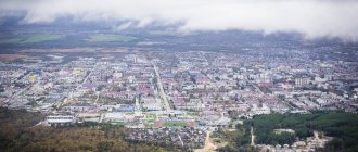
Sakhalin is located on the eastern borders of Russia. The island is washed by two seas at once - the Sea of Okhotsk and the Sea of Japan. It is separated from the mainland by the narrow Tatar Strait. Yuzhno-Sakhalinsk is nestled at the very south of the narrow tip of the island. The city has the status of the center of the Sakhalin region. The number of inhabitants does not exceed 200 thousand people. However, in terms of population it ranks sixth among the cities of the Far East. It is separated from Moscow by 6400 kilometers! The time difference with the capital is 8 hours. The city is located in a seismic zone.
Typically, island cities serve as ports and are therefore located on the coast. In Yuzhno-Sakhalinsk, fate turned out differently. The city is located far from the sea: 50 kilometers from the west coast, 20 from the south and 25 from the east. It is framed from the east by a mountain range. Nearby stands Chekhov Peak (1045 meters) - the highest Sakhalin peak. The role of a seaport is performed by the city of Korsakov, located 40 kilometers south of the regional capital.
Fog is a frequent visitor to the island
The city is located on the banks of the Susuya River. Despite its small size - 83 kilometers - it is considered the largest waterway in the southern part of Sakhalin. Translated from the language of the Ainu - the indigenous inhabitants of the island - its name means “river overgrown with willow.” Susuya quite quickly covers the path from its source to its mouth and flows into the Sea of Okhotsk.
The location of the city determined the special microclimate of Yuzhno-Sakhalinsk. The official name for this climate is temperate monsoon. The coldest month is January, and the warmest month is August. The average temperatures in these months are, respectively, minus 12 and plus 17 degrees. Most sunny days occur in May, June and September.
High humidity makes its own adjustments - in summer it is hot and stuffy even in the shade, and in winter slightly negative temperatures cause the same sensations as in frost. The best time to visit the island is from June to September. Despite the fact that Yuzhno-Sakhalinsk is located at the latitude of Monaco, it is equated to the regions of the Far North.
Beautiful capes of Sakhalin Island
The capes on Sakhalin and other surrounding islands are different from each other and deserve special attention. Each cape is a separate masterpiece, created by the best sculptor and artist in the world - nature.
Cape Stolbchaty
- Coordinates on the map: 44.025579, 145.676193.
The amazing cape on Kunashir Island is the most amazing sight of Sakhalin. On the seashore, unusual traces of the ancient eruption of the Mendeleev volcano have been preserved: pentagonal and hexagonal basalt pillars fit tightly together, forming high cliffs.
From above, it seems as if Stolbchaty is covered with tiles, which makes it look like the creation of human hands. Experts were so impressed by the cape that they declared it a natural monument of world significance.
Cape Crillon
- Coordinates: 45.896118, 142.080860.
The picturesque cape is located in the very south of Sakhalin Island. Tourists to Crillon are attracted not only by the interesting landscape and excellent views of the sea, but also by historical sights created by human hands.
The cape is dominated by an ancient lighthouse, built at the end of the 19th century, and several modern buildings, including a meteorological station and a border post. There is also a mass grave of border guards who died during the Great Patriotic War.
Cape Giant
- Coordinates: 46.625542, 143.519961.
The stone giant looks amazing in any weather. The main decoration of the giant cape is the bizarre rocks with unusual arches and mysterious caves. The incredible beauty of the landscape is complemented by evergreen forests on the tops of the cliffs, as well as pebble beaches and foamy waves at their feet.
The smell of pine needles mixes with the sea breeze, the sound of the sea merges with the cries of birds. Birds have long taken a liking to the picturesque rocks and build nests on them, while seals and seals set up rookeries on the shore.
Cape Aniva
- Coordinates: 46.031390, 143.415343.
The rocky cape in the southeast of Sakhalin is the meeting place of the Seas of Okhotsk and the Seas of Japan. The old name for the inaccessible rocks is Nakashiretoko. At the very edge of the cape, merging with the bare rocks, stands a Japanese atomic lighthouse, darkened by time and water, built in the late 30s of the last century. Aniva attracts not only ecotourists, but also lovers of “abandonment”.
The link location cannot be changed
By Russian standards, Yuzhno-Sakhalinsk is a fairly young city. It was founded in 1882 as a settlement for convicts. At that time the village was called Vladimirovka. The question arises: why were the convicts exiled so far away, if Siberia with its endless expanses was much closer to the capital? The answer is simple. It was necessary to populate the remote territories of the empire, but no one wanted to go to these regions voluntarily.
Coat of arms of Yuzhno-Sakhalinsk
In the 19th century, Sakhalin had the official status of a place of hard labor and exile. The place for the settlement was chosen for a reason - there were arable lands all around. This allowed residents to provide themselves with grain, meat and milk. The sea supplied plenty of fish. There were four settlements in total on the island, but the village of Vladimirovka grew the fastest. At that time, 130 people lived in it. Almost all of them, with the exception of children, were convicts.
At the beginning of the last century, it was already a full-fledged town with craft workshops, a post office, a small school, shops and a church. Alas, he did not remain Russian for long. In 1905, the Japanese captured the island and renamed Vladimirovka Toyoharu. The occupation continued until the end of World War II, and only in 1945 Sakhalin returned to the USSR. In 1946, the Yuzhno-Sakhalin region appeared on the map of the country. The city of Toyohara took over the capital's functions, which was immediately renamed Yuzhno-Sakhalinsk.
Reserves and protective zones of Sakhalin
Sakhalin nature reserves are not numerous, but they occupy a significant part of the region. Specialists work all year round to preserve the unique nature of the islands.
Kuril Nature Reserve
- Coordinates: 44.083333, 145.983333.
The reserve, founded in 1984, includes several Kuril Islands, led by Kunashir Island, as well as the adjacent marine area. The state, together with scientists, protect the unique flora and fauna both on land and under water.
The landscape of the protected area is beautiful, at the foot of formidable volcanoes, colorful valleys lie, rivers and lakes splash. History buffs will also find something to see on the islands; among the rocks and trees there are traces of ancient man and more modern structures from the time of Japanese rule.
Poronaisky Reserve
- Coordinates: 48.925278, 144.508889.
In 1988, the eastern part of Sakhalin Island was recognized as a protected area. There are more than a hundred rivers and reservoirs in the territory. Almost the entire area is covered with forests; a wide variety of trees grow here: stone birches, Sayan spruces, cedars, Erman birches, Sakhalin firs.
The wildlife of the reserve is no less diverse, with 600 species, 40 of which are endemic. The most numerous inhabitants of the reserve are birds; out of 170 species of birds, several are included in the Red Book: osprey, Sakhalin musk deer, peregrine falcon, mandarin duck, grouse, white-tailed eagle, Aleutian tern, Steller's sea eagle.
Noisy flocks nest on Cape Terpeniya, where seals and fur seals also make rookeries. Among other mammals, otters, brown bears, Asian chipmunks, reindeer and sables are especially notable.
Moneron Natural Park
- Coordinates: 46.253901, 141.233820.
A unique marine natural park was founded on the island of the same name in 2007. The entire island is one huge extinct volcano, covered with forests, grasses, rivers and ponds.
There are no human settlements on Moneron, so no one and nothing prevents animals from existing and reproducing in their natural habitat. There are many birds in the park; feathered inhabitants nest on rocks and feed on fish, which are found in large quantities in coastal waters.
Japanese heritage
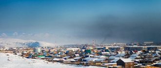
Yuzhno-Sakhalinsk cannot boast of outstanding architectural masterpieces. Since it was originally built with wooden houses, severe fires often occurred. For this reason, no old buildings have been preserved in the city. The legacy of the Japanese occupation was a system of clear rectangular buildings. All streets ran either parallel or perpendicular to the railway. There was no greenery at all in the city center. Only on the outskirts did the Japanese create a small park with a pond.
Vladimirovka in the 1880s
Traditionally, the Japanese built very densely. Single-story frame shacks huddled together. They did not have yards or outbuildings. The internal plywood walls of the houses were often sliding, and the floors were earthen. The dwellings were heated by portable iron stoves, from which ceramic pipes were routed along the outer walls. Alas, typical Japanese residential buildings have not survived to this day.
Toyohara in the 1930s
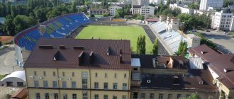
This period is evidenced only by documents and photographs in the Sakhalin Regional Museum of Local Lore. It is interesting because it occupies a former Japanese building, built in the traditional “teikan-zukuri” style. This style appeared in Japan in the Middle Ages, and then became popular again at the beginning of the 20th century. There are no other buildings like this in Russia. The museum's exposition gives a complete picture not only of the history of the development of Sakhalin, but also of the flora and fauna of the island. Recently, another exhibit was a Japanese tank from the Second World War.
Memorable Sakhalin lakes
Among the numerous reservoirs of Sakhalin, several unique lakes stand out, the likes of which cannot be found anywhere in the world.
Lake Goryacheye
- Coordinates: 43.872573, 145.505948.
The name of the reservoir may seem strange at first glance. However, the name “Hot” is fully justified: the lake, 62 meters deep, splashes in the basin of the Golovin volcano and warms up to unnaturally high temperatures due to hot volcanic gases.
Goryacheye receives an additional portion of heat from the neighboring Boiling Lake through a canal dug by the Japanese. Despite the temperature and other features of the reservoir, many tourists are not afraid to swim in its azure waters.
Boiling Lake
- Coordinates: 43.864332, 145.499606.
The neighbor and sibling of the Goryachee reservoir has its name for a reason: the volcano maintains the water temperature in the lake at around 80 °C, which is close to the boiling point. The pond is so hot that even approaching it is not only difficult, but also dangerous.
The chemical composition of lead-gray water adds even more danger, which includes toxic concentrations of antimony, arsenic and heavy metal salts that are no less harmful to human health.
Due to the high temperature and toxic substances, the lake is dead, there are no fish in it, and no animals live on the shores. Many years ago, the previous owners of the island - the Japanese - mined sulfur in these parts. To this day, in the vicinity of the reservoir you can find large cast-iron boilers that were used to process the substance.
Lake Busse
- Coordinates: 46.535065, 143.329968.
A vast lagoon lake near Aniva Bay received the name of the first head of Sakhalin. Despite the recharge from freshwater sources, the reservoir is salty, so its inhabitants are predominantly marine: fish, shellfish, crabs, oysters, shrimp, scallops and others. Ahnfeltia algae grows at the bottom, from which agar-agar is produced, a plant analogue of gelatin necessary for making jelly.
The main gastronomic entertainment for tourists is to pick fresh oysters with their own hands and immediately taste them without additional preparation. The raw dish is considered an exquisite delicacy worthy of the best restaurants in Paris. Entire families often vacation on the lake; many stay for several days and spend the night in tents. At night Busse looks charming, the starry sky is reflected in the water surface, the splash of water gently lulls you to sleep.
Vavai Lakes
- Coordinates: 46.611261, 143.250367.
Two lakes – Big and Small – are connected to each other, like Siamese twins. The banks of the reservoirs are overgrown with reeds, sedges and ferns. A short distance away is the natural monument Ozersky Spruce Forest. Both lakes are freshwater; many river fish swim in their waters: taimen, crucian carp, rudd, carp. The surrounding area is home to foxes and many other wild animals.
Lake Tunaicha
- Coordinates: 46.759600, 143.221262.
One of the largest lakes in Sakhalin is located in the Korsakov region, not far from the Sea of Okhotsk. Three dozen fish are found in Tunaich, and various mammals, including rare endangered species, live in the vicinity of the reservoir.
The following birds nest on the banks:
- whooper swan,
- mandarin duck,
- white-tailed eagle, etc.
The lake is relatively shallow, with a maximum depth of 34 meters. In summer, the water quickly becomes warm and local residents, tired of the cold winter, as well as visiting tourists, come to the shores of the reservoir.
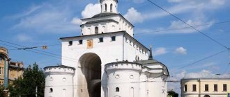
In the footsteps of Chekhov
In 1890, Chekhov visited the convict island. The result was his book “Sakhalin Island”. An entire museum is dedicated to this book and the visit of the famous writer, which is called the Literary and Art Museum of A.P. Chekhov’s book “Sakhalin Island”. The city also has a Geological Museum, a Zoological and Botanical Park, a Bear Museum and a regional Art Museum.
Nishiichijo-doori Street in Toyohara (now Lenin Street)
There are many interesting places in the immediate vicinity of Yuzhno-Sakhalinsk. The climb to Chekhov Peak, which is located not far from the city, is very popular. Since the peak is only one kilometer high, the ascent can hardly be called conquest. Rather, it is a walk through picturesque places along a marked path, along which not only rosemary, blueberries, lingonberries and rowan grow, but even bamboo!
Railway Bureau Karafuto
The Japanese considered the mountain sacred, so they built a small temple on the top, dedicating it to the sun goddess Amaterasu. It has survived to this day. A stunning panorama opens up from the top. They say that in good weather you can actually see the Japanese island of Hokkaido. The trail is especially picturesque in autumn, when the color palette is complemented by gold and crimson.
Outdoors
People also come to Yuzhno-Sakhalinsk to improve their health. The most famous health resort is the Sinegorsk Mineral Waters sanatorium. Healing water was discovered in these places at the beginning of the 20th century. Local residents were surprised by the water in the Sinegorka River, which had a characteristic sour taste. The first hospital was built here by the Japanese. Leaving the island, they disguised and concreted the source. It was only possible to rediscover it in the 60s.
The city has a Geological Museum
The peculiarity of the local water is that it has a high arsenic content. Don't be scared! In small doses this element is useful. It’s not for nothing that ancient healers said: “Everything is poison and everything is medicine. It's just a matter of quantity." Arsenic mineral waters are extremely rare in nature. In Yuzhno-Sakhalinsk, this natural medicine is used to treat diseases of the joints and lungs, as well as nervous disorders. An additional option to Sinegorsk mineral water can be the healing mud in the village of Goryachiye Klyuchi.
In order not to lead to illnesses, it is better to engage in their prevention. The sports and resort complex “Mountain Air” provides excellent opportunities for this. It is located just three kilometers from Yuzhno-Sakhalinsk. In winter, there are nine slopes, to which skiers are transported by a gondola-chair lift.
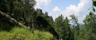
In the immediate vicinity of Yuzhno-Sakhalinsk there are many remarkable rocks
In summer it is worth taking a walk to the Yuzhno-Sakhalinsky mud volcano. It is located just two dozen kilometers northwest of the city. The best period to visit is from May to October. By jeep you can get almost to the volcano. The walk from the Novaya Derevnya railway station to the crater takes about two hours. The area of the mud field is six hectares. This is the largest mud volcano in Russia!
You can go skiing in Yuzhno-Sakhalinsk
It is also worth visiting the picturesque outlier “Frog”. It got its name from its characteristic shape, reminiscent of a sitting frog, ready to jump. An unusual natural formation is located near the village of Vestochka, two dozen kilometers from Yuzhno-Sakhalinsk. In addition to the rock, there is a river with a beautiful waterfall in which you can swim. Since the “Frog” is considered a “place of power,” the village even has an esoteric museum.
Mud volcano
A number of excursions have been developed for tourists coming to Yuzhno-Sakhalinsk. For example, there is an hour and a half trip by motor boat to a sea lion rookery in the Sea of Japan near the city of Nevelsk. There is an excursion to the cascade of Salyut waterfalls. Two waterfalls, 12 and 3 meters high, bubble near the former village of Svetlyaki. In the most picturesque place of the Nevelsky district there is a “Scandinavian trail” three kilometers long.
In the port of Korsakov, tourists are invited to get acquainted with the monastery, climb the Mountain of Tears, look at the monument to the First Hydrographers, and also take spectacular pictures from the observation deck. There is a walking route called “Cape Ostry”. It starts in the city of Dolinsk, passes through the cape, winds along the banks of small rivers and ends in the village of Lesnoye. In these places it is quite possible to meet a bear.
Tourists are offered an excursion to the sea lion rookery
Few people know that Sakhalin offers such a service as diving. Dive sites are located near small islands in the Sea of Japan. In particular, they are located 90 kilometers east of Yuzhno-Sakhalinsk near the village of Prigorodnoye and the city of Nevelsk. They offer diving in the company of sea lions. And near Moneron Island, thanks to the Tsushima Current, you can even admire the tropical underwater fauna.
The beauty of Sakhalin
And it’s really hard to believe (after all, it’s a region of the Far North!) that there is beach tourism on Sakhalin. Nevertheless, it is true. There are several places for recreation in the vicinity of Yuzhno-Sakhalinsk. The most famous are Aniva Beach and the beach in the village of Prigorodny on the shore of Aniva Bay. There are also beaches in Yablochny on the Sea of Japan and in the village of Okhotsk on the Sea of Okhotsk. There are about 40 hotels in Yuzhno-Sakhalinsk. It is impossible to stay here without a roof over your head.
The most famous places in the Sakhalin region: TOP-3
The natural attractions of Sakhalin are surprisingly diverse; each object is worthy of the attention of tourists. However, we can especially highlight three natural monuments that better than others demonstrate the uniqueness of the region and its differences from other regions of Russia.
Tyuleniy Island
- Coordinates on the map: 48.503253, 144.629144.
The island's name speaks for itself: a rocky stretch of land in the middle of the Sea of Okhotsk is home to hundreds of seals, fur seals and sea lions. In spring, the coast of the attraction is literally dotted with gray, black and red carcasses of these amazing sea animals.
Large animals coexist quite peacefully with birds that nest on higher rocks. The island is under state protection and lies outside of water and air routes so that passing ships and flying planes do not frighten away rare mammals.
Daginsky thermal springs
- GPS coordinates: 52.045720, 143.081736.
A complex of thermal springs with an area of 9 hectares is located in the Nogliki region near Dagi Bay. About 60 springs with a temperature of 50 ° C come out of the ground at a speed of up to 3 liters per second.
Water is rich in alkali and silicic acid and therefore helps with a number of diseases from diseases of the skin and nervous system to disorders of the musculoskeletal system.
Some springs are well equipped; special baths under domes are equipped for bathing. Currently, a health resort operates next to the springs.
Volcano Tyatya
- Coordinates: 44.353707, 146.251319.
A formidable active volcano with a height of 1800 meters has been rising on the coast of the Sea of Japan for 12 centuries and has long become the hallmark of the Kuril Islands.
According to scientists, serious eruptions occur only once every thousand years. The last strong eruption occurred in 1973, when the volcano drove away local residents.
Nevertheless, the terrible giant periodically reminds of his strength, threateningly releasing clouds of black smoke into the sky and scaring away planes.
How to get there
Currently, tourists mainly travel to Yuzhno-Sakhalinsk by air. The number of flights and the list of airports from which flights operate depend on the season. There are flights from Yekaterinburg, Novosibirsk, Khabarovsk, Vladivostok. Planes from Moscow fly to Sakhalin all year round. Travel time is about 8 hours. In winter, the airport on the island may be closed for some time due to weather conditions. Since the airport is located within the city, the easiest way to get to the center is by taxi.
Less commonly used is the ferry option from Vanino (Khabarovsk Territory) to Kholmsk (Sakhalin). In this case, the journey takes about 14 hours. You can buy a ticket without a cabin (seated seats) or take a place in a one-, two-, or eight-berth cabin. There are trains from Khabarovsk to the port of Vanino (the journey takes 25 hours). Buses run from the port of Kholmsk to Yuzhno-Sakhalinsk (93 km). Since the number of seats on the ferry is limited, tickets should be purchased in advance. This is especially true in the summer.