Stone-on-Obi
(until 1933 -
Kamen
), a city in Russia, the administrative center of the Kamensky district of the Altai Territory, the second cathedral city of the Slavgorod diocese. Located in the northwestern part of the region, on the left bank of the river. Ob, 208 km from Barnaul. Pier. Large railway station on the Middle Siberian Railway (Karasuk–Kamen, Altaiskaya–Kamen). Highways connect the city with Barnaul, Novosibirsk, and neighboring areas. Population - 42,177 people (January 1, 2014) [1]
- On the map: Yandex.Map, Google map
Village Stone
first mentioned in written sources in 1751. It received its name due to the emergence of a spur of the Salair Ridge, smoothed by time, to the surface of the earth. Gradually, the advantageous position on a large river surrounded by numerous villages turned Kamen into a center of agricultural production and intra-Siberian trade. Since 1886, Kamen has been a large merchant village. Thanks to the presence of the pier, it became a center for the purchase and shipment of wheat, and at the beginning of the century, butter.
At the end of the 1890s, the village belonged to the Burlinsky volost of the Barnaul district of the Tomsk province, no later than 1911 it became a volost center. The rapid development of trade led to the gradual transformation of the village into a city. Branches of large trading companies appeared here. In 1912, the village ranked 4th in the Tomsk province in terms of trade turnover, after Tomsk, Novonikolaevsk and Barnaul. Industry was poorly developed, with the exception of flour milling. The center of the village was built up with stone shops and urban residential buildings, a branch of the Siberian Trade Bank was opened, there was a cinema, a telephone network (since 1913), several educational institutions: a gymnasium, a two-year school, a parochial school (built in 1892 at the expense of the population). Novaya Gazeta and Narodnaya Gazeta were published.
On May 10, 1915, the village was given city status. The construction of the Altai Railway past the Stone in the same year had a negative impact on its transport and trade significance. Since 1917, Kamen has been the administrative center of Kamensky district.
A feature of the political development of the city in 1917 was the hegemony of the Bolsheviks, who were among the first in Siberia to form a party organization separate from the Mensheviks and took power in the city peacefully. Power passed to the Soviets at the end of December 1917. The Executive Committee of the Council adopted the name “district council of people’s commissars”. At the suggestion of the anarchists elected to the Council, the issue of creating the Kamensk district federal republic was discussed. Local anarchists wanted to achieve independence from the province so as not to supply food to the center. In February - March 1918, a counter-revolutionary rebellion broke out in Kamen and its district, led by the head of the district police, former lieutenant Samoilov. The rebellion was suppressed, moreover, Soviets appeared in those villages of the district where they had not previously existed. On June 9, 1918, the city was taken without a fight by the White Guards, who arrived by ship from Novonikolaevsk. Soviet power in the city was restored on November 28, 1918 by partisan detachments and units of the regular Red Army that occupied Kamen.
Since April 10, 1933, the city has had its modern name - Kamen-on-Obi
.
On the first day of the Great Patriotic War, a rally was held on the pier, and 300 volunteers went to the front. During the war, 4,388 people went to the front, of which 2,484 people died.
In the post-war years, Kamen-on-Obi developed as an agricultural center in the region. The development of virgin and fallow lands had a great influence on the development of the city. In 1954, the Central Siberian Mainline of the West Siberian Railway began. In December 1961, the railway station was put into operation, and a village began to be built around it. In the 1960s, significant changes occurred in the structure of industrial enterprises as a result of the reorganization of industrial cooperatives into factories and factories. In addition to the previously existing enterprises, new ones arose: a clothing, weaving and furniture factory, a metal plant, a fish factory, a brick, asphalt, film and crushed stone plant. In 1979, construction of the largest elevator beyond the Urals was completed.
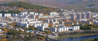
The economy of modern Kamen-on-Ob is represented by enterprises in the food and light industries, as well as cinema and mechanical repair plants, and the production of building materials. One of the significant and bright events of 2010 in the city was the launch of the second railway bridge across the Ob River, 977 meters long.
In the early 2000s, the city had a cultural center, two cinemas, a stadium, a children's and youth sports school, a local history museum, a central and children's library, an art gallery, three music and art schools. There were three secondary specialized educational institutions - a medical school, a pedagogical college, an agricultural technical school, and three vocational schools. By the beginning of the 2010s, a sports complex with a swimming pool was opened in the city.
Statistics
- 1859 - 20 households, 122 people. [2]
- 1899 - 450 households, of which 14 were non-peasant, 3,584 people. [3]
- 1911 - 1621 yards, 15107 people. [4]
- 1926 - 22.9 thousand people. [5]
- 1959 - 30.1 thousand people. [5]
- 1970 - 35.6 thousand people. [5]
- 1979 - 40 thousand people. [5]
- 1989 - 42.4 thousand people. [5]
- 1996 - 44.8 thousand people. [5]
- 2002 - 44.4 thousand people. [5]
- 2005 - 45.5 thousand people. [5]
Stone-on-Obi
History: Documentary evidence of the formation of Stone-on-Ob dates back to 1751. It received its name due to the emergence of a spur of the Salair Ridge, smoothed by time, to the surface of the earth. In 1915, the village received city status. At that time, 15 thousand people lived in Kamen-on-Ob. In 1918-1919 the city itself and Kamensky district became one of the major centers of the mass partisan movement against Kolchakism.
The development of virgin and fallow lands had a great influence on the development of the city. During the years of virgin lands in the Kamensky district, 51 thousand 300 hectares of land were developed.
With the construction of the Karasuk-Kamen and Altaiskaya-Kamen railway lines, the city became a major station on the Central Siberian Railway, one of the centers of the agro-industrial complex. Highways connect Kamen-on-Obi with Barnaul, Novosibirsk, and neighboring areas.
In 1973, the Kamenvodstroy trust was formed, which was supposed to carry out the construction of the Kulundinsky canal with a length of 180 km. By 1983, construction of the canal was completed.
Today Kamen-on-Obi is a city of regional significance with a population of more than 42.5 thousand people. Kamen-on-Obi began to acquire an urban appearance in the 70s. The modern infrastructure of the city is emphasized by the recreation area of the Ob River embankment with the Ob Hotel, the Culture and Leisure Park, the Water Park attraction, and the beach.
On the opposite bank of the river there is a unique ribbon forest, a country recreation area, and a year-round recreation camp for children and adults “Sunny Beach” for 140 places in the village. Dresvyanka. In winter, there is a ski base and sports grounds for winter sports, which are very popular among residents and guests of the city.
Population: 42648 people.
Geographical location: Kamen-on-Obi is located in the northwestern part of the region, on the left bank of the Ob River. Distance to Barnaul – 208 km
Climate: continental climate. The average temperature in January is -19.2C, in July +25C. Annual precipitation is 360 mm.
Minerals: sand, clay, there are deposits of building crushed stone.
Economic features: the city's industry is mainly agricultural. The leading place in production volume is occupied by the food and processing industry. Currently, the city's industry is represented by more than 40 enterprises of all forms of ownership, including small enterprises. The city has a metal plant, two meat processing plants, a butter and cheese plant, a distillery, a fish factory, a bakery, a poultry factory, an elevator, a mechanical repair plant, a weaving factory, a furniture factory, a knitting factory, a garment factory, a crushed stone plant and others.
Honorary Citizen of the Altai Territory Evgeniy Erofeevich Parfenov was born in the town of Kamen-on-Obi, West Siberian Territory. The participant of the Great Patriotic War made a huge contribution to the economic and social development of his native city and its improvement. Thanks to his creative work, skill and talent as a leader, new industrial enterprises were created in Kamen-on-Ob, culture, public education and medicine developed, the communications system was improved, and transport developed. On September 2, 2002, Hero of Socialist Labor Evgeniy Erofeevich was awarded the title “Honorary Citizen of the Altai Territory.”
Kamen-on-Obi (until 1933 - Kamen), a city in Russia, the administrative center of the Kamensky district of the Altai Territory, the second cathedral city of the Slavgorod diocese. Located in the northwestern part of the region, on the left bank of the river. Ob, 208 km from Barnaul. Pier. Large railway station on the Middle Siberian Railway (Karasuk–Kamen, Altaiskaya–Kamen). Highways connect the city with Barnaul, Novosibirsk, and neighboring areas. Population - 42,177 people (January 1, 2014)
The village of Kamen was first mentioned in written sources in 1751. It received its name due to the emergence of a spur of the Salair Ridge, smoothed by time, to the surface of the earth. Gradually, the advantageous position on a large river surrounded by numerous villages turned Kamen into a center of agricultural production and intra-Siberian trade. Since 1886, Kamen has been a large merchant village. Thanks to the presence of the pier, it became a center for the purchase and shipment of wheat, and at the beginning of the 20th century, butter.
At the end of the 1890s, the village belonged to the Burlinsky volost of the Barnaul district of the Tomsk province, no later than 1911 it became a volost center. The rapid development of trade led to the gradual transformation of the village into a city. Branches of large trading companies appeared here. In 1912, the village ranked 4th in the Tomsk province in terms of trade turnover, after Tomsk, Novonikolaevsk and Barnaul. Industry was poorly developed, with the exception of flour milling. The center of the village was built up with stone shops and urban residential buildings, a branch of the Siberian Trade Bank was opened, there was a cinema, a telephone network (since 1913), several educational institutions: a gymnasium, a two-year school, a parochial school (built in 1892 at the expense of the population). Novaya Gazeta and Narodnaya Gazeta were published.
On May 10, 1915, the village was given city status. The construction of the Altai Railway past the Stone in the same year had a negative impact on its transport and trade significance. Since 1917, Kamen has been the administrative center of Kamensky district.
A feature of the political development of the city in 1917 was the hegemony of the Bolsheviks, who were among the first in Siberia to form a party organization separate from the Mensheviks and took power in the city peacefully. Power passed to the Soviets at the end of December 1917. The Executive Committee of the Council adopted the name “district council of people’s commissars”. At the suggestion of the anarchists elected to the Council, the issue of creating the Kamensk district federal republic was discussed. Local anarchists wanted to achieve independence from the province so as not to supply food to the center. In February - March 1918, a counter-revolutionary rebellion broke out in Kamen and its district, led by the head of the district police, former lieutenant Samoilov. The rebellion was suppressed, moreover, Soviets appeared in those villages of the district where they had not previously existed. On June 9, 1918, the city was taken without a fight by the White Guards, who arrived by ship from Novonikolaevsk. Soviet power in the city was restored on November 28, 1918 by partisan detachments and units of the regular Red Army that occupied Kamen.
Since April 10, 1933, the city has had its modern name - Kamen-on-Obi.
On the first day of the Great Patriotic War, a rally was held on the pier, and 300 volunteers went to the front. During the war, 4,388 people went to the front, of which 2,484 people died.
In the post-war years, Kamen-on-Obi developed as an agricultural center in the region. The development of virgin and fallow lands had a great influence on the development of the city. In 1954, the Central Siberian Mainline of the West Siberian Railway began. In December 1961, the railway station was put into operation, and a village began to be built around it. In the 1960s, significant changes occurred in the structure of industrial enterprises as a result of the reorganization of industrial cooperatives into factories and factories. In addition to the previously existing enterprises, new ones arose: a clothing, weaving and furniture factory, a metal plant, a fish factory, a brick, asphalt, film and crushed stone plant. In 1979, construction of the largest elevator beyond the Urals was completed.
The economy of modern Kamen-on-Ob is represented by enterprises in the food and light industries, as well as cinema and mechanical repair plants, and the production of building materials. One of the significant and bright events of 2010 in the city was the launch of the second railway bridge across the Ob River, 977 meters long.
In the early 2000s, the city had a cultural center, two cinemas, a stadium, a children's and youth sports school, a local history museum, a central and children's library, an art gallery, three music and art schools. There were three secondary specialized educational institutions - a medical school, a pedagogical college, an agricultural technical school, and three vocational schools. By the beginning of the 2010s, a sports complex with a swimming pool was opened in the city.
Links[edit]
Notes[edit]
- ^ abcdef Law No. 28-ZS
- ^ abcdefg Law No. 41-ZS
- https://altlib.ru/files/text/k2011/37.pdf
- ^ abc Federal State Statistics Service (2011). “All-Russian Population Census 2010. Volume 1" [All-Russian Population Census 2010, vol. 1]. All-Russian Population Census 2010 [All-Russian Population Census 2010]
. Federal State Statistics Service. - "On the Calculation of Time". Official Internet portal of legal information
. June 3, 2011. Retrieved January 19, 2022. - Post office. Information and computing center of OASU RPO. ( Post office
).
Search for postal service objects ( postal Search for objects
) (in Russian) - ↑
Federal State Statistics Service of Russia (May 21, 2004).
“The population of Russia, the constituent entities of the Russian Federation as part of federal districts, urban settlements, settlements, settlements of 3 thousand or more people” [Population of Russia, its federal districts, federal districts, districts, urban settlements, rural settlements - administrative centers and rural settlements with a population of more than 3000] (XLS). All-Russian Population Census of 2002 [All-Russian Population Census of 2002]
. - “All-Union Population Census of 1989. The current population of union and autonomous republics, autonomous regions and districts, territories, negative phenomena, urban settlements and rural district centers” [All-Union Population Census of 1989: current population of union and autonomous republics, Autonomous regions and districts , territories, regions, districts, urban settlements, villages performing the functions of district administrative centers. All-Union Population Census of 1989 [All-Union Population Census of 1989]
.
Institute of Demography of the National Research University: Higher School of Economics [Institute of Demography of the National Research University: Higher School of Economics]. 1989 - via Demoscope Weekly
. - “All-Union Population Census of 1979. National composition of the population by regions of Russia” [All-Union Population Census of 1979. Ethnic composition of the population by regions of Russia] (XLS). All-Union Population Census of 1979 [All-Union Population Census of 1979]
.
1979 - via Demoscope Weekly
(website of the Institute of Demography of the State University - Higher School of Economics. - Law No. 28-ZS, as amended until September 2, 2015.
- Law No. 114-ZS
- Law No. 70-ZS
City of Kamen-on-Obi
Kamen-na-Obi (until 1933 - Kamen) is a city (since 1915) in Russia, the administrative center of the Kamensky district and the urban settlement of Kamen-na-Obi, Altai Territory.
Population - 40,795 people. (2018).
| City Kamen-on-Obi Coat of arms |
| A country | Russia, Russia |
| Subject of the federation | Altai Territory Altai Territory |
| Coordinates | Coordinates: 53°47′31″ N. latitude 81°20′55″ h. d. / 53.791944° s. latitude 81.348611° e. d. (G) (O) (Y) 53.791944, 81.34861153°47′31″ s. latitude 81°20′55″ h. d. / 53.791944° s. latitude 81.348611° e. d. (G) (O) (I) |
| Mayor | Rutkovsky Valery Genievich [1] |
| Based | 1751 |
| Former names | to 04/10/1933 - Stone |
| City with | 1915 |
| Square | 48.79 km² |
| Center height | 120 m |
| Climate type | continental |
| Population | ▼43,988 [2] people |
| Ethnobury | Kamenets, Kamenets |
| Timezone | UTC+7 |
| Telephone code | +7 38584 |
| Postcode | 658700 |
| Vehicle code | 22 |
| OKATO code | 01 410 |
| Official site | https://kamen-na-obi.org/ |
Kamen-na-Obi (until 1933 - Kamen) is a city (since 1915) in Russia, the administrative center of the Kamensky district of the Altai Territory. Population 43.2 thousand inhabitants (as of January 1, 2012), with subordinate rural settlements - 44.0 thousand inhabitants. Area 49 km². Since 2005, the village of Plotinnaya station has been subordinate to the city.
Video about the city
Recommendations
Notes
- ^ a b c d f g
Law No. 28-ZS - ^ a b c d f g gram
Law No. 41-ZS - https://altlib.ru/files/text/k2011/37.pdf
- ^ a b c
Federal State Statistics Service of Russia (2011).
“All-Russian Population Census 2010. Volume 1" [All-Russian Population Census 2010, vol. 1]. All-Russian Population Census 2010 [All-Russian Population Census 2010]
(in Russian). Federal State Statistics Service. - "On the calculation of time." Official Internet portal of legal information
(in Russian). June 3, 2011. Retrieved January 19, 2022. - Post office. Information and computing center of OASU RPO. ( Post office
).
Search for postal facilities ( Search for postal facilities
) (in Russian) - Federal State Statistics Service of Russia (May 21, 2004). “The population of Russia, the constituent entities of the Russian Federation as part of federal districts, urban settlements, urban settlements, settlements, settlements is 3 thousand or more people” [Population of Russia, its federal districts, constituent entities of the federation, districts, urban settlements, rural settlements - administrative centers, rural settlements with a population of more than 3000 people] (XLS). All-Russian Population Census of 2002 [All-Russian Population Census of 2002]
(in Russian). - “All-Union Population Census of 1989. The current population of union and autonomous republics, autonomous regions and districts, territories, regions, urban settlements and villages. All-Union Population Census of 1979. National composition of the population by regions of Russia” [All-Union Population Census of 1979. Ethnic composition of the population by regions of Russia] (XLS). All-Union Population Census of 1979 [All-Union Population Census of 1979]
(in Russian).
1979 - via Demoscope weekly
(website of the Institute of Demography of the State University - Higher School of Economics. - Law No. 28-ZS, as amended until September 2, 2015.
- Law No. 114-ZS
- Law No. 70-ZS
Story
The founding date of the settlement is considered to be 1751. Previously, the founding date was considered to be 1670, however, in 2000, a scientific study was carried out, during which it was found that the founding date of the settlement was 1751. The settlement was formed by the merger of several small villages. The name of the village has a literal explanation: the village was named so because of the outcropping of rock from a spur of the Salair Ridge to the surface of the earth.
The favorable geographical location and the presence of a pier determined the economic development of the village. By the end of the 19th century, the village of Kamen was a large trading village in the Barnaul district of the Tomsk province. Local merchants established economic trade ties with Russian and European enterprises. The main commodity sold at that time was grain. The largest suppliers of wheat were local merchants Vinokurov and Falkov. In 1912, in terms of trade turnover, the village of Kamen ranked 4th in the Tomsk province, after Tomsk, Novonikolaevsk and Barnaul.
After the construction of the Trans-Siberian Railway in Novonikolaevsk (now Novosibirsk), the importance of water transport decreased and the economic role of the village in the region began to gradually fade away. However, railway transport did not develop so quickly and the village remained a major grain transshipment point. In 1930, according to the project and under the leadership of Yu. V. Kondratyuk, a unique structure “Mastodon” was built - the largest wooden granary in the world with a capacity of 13,000 tons. This structure was built without a single nail. In the mid-1990s, Mastodon was seriously damaged during a major fire and was subsequently destroyed.
On May 10 (23), 1915, the village of Kamen was given the status of a city. Since April 10, 1933, the city has had its modern name - Kamen-on-Obi.
During the Great Patriotic War, some enterprises and institutions were evacuated to Kamen-on-Ob. One of these was the Barnaul Pedagogical Institute, on the basis of which the Kamensk Pedagogical School was organized.
In the post-war years, Kamen developed as an agricultural center in the region. Thus, in the early 1960s, the Central Siberian Mainline of the West Siberian Railway was put into operation, which made it possible to establish stable transport links with major cities of Siberia. From 1973 to 1983, the Kulunda main canal was built, intended to irrigate agricultural lands in the steppe zone of the Altai Territory. In 1977, the head pumping station and the head section, starting in Kamen-on-Obi, were put into operation. In 1979, construction of the largest elevator beyond the Urals was completed.
Pre-revolutionary period
The founding date of the settlement is considered to be 1751. Previously, the founding date was considered to be 1670, however, in 2000, a scientific study was carried out, during which it was found that the founding date of the settlement was 1751. The settlement was formed by the merger of several small villages. The name of the village has a literal explanation: the village was named so because of the outcropping of rock from a spur of the Salair Ridge to the surface of the earth.
The favorable geographical location and the presence of a pier determined the economic development of the village. By the end of the 19th century, the village of Kamen was a large trading village in the Barnaul district of the Tomsk province, and became (until 1925) the center of the Kamensk volost. Local merchants established economic trade ties with Russian and European enterprises. The main commodity sold at that time was grain. The largest suppliers of wheat were local merchants Vinokurov and Falkov. In 1912, in terms of trade turnover, the village of Kamen ranked 4th in the Tomsk province, after Tomsk, Novonikolaevsk and Barnaul. There was also a handicraft industry in the city and county: tanneries, oil churns, mills and other small enterprises for processing agricultural raw materials. In the district there were about 200 butter-making artels, many private butter factories and grain storage centers. The labor force, represented by landless peasant migrants from Central Russia, was unusually cheap.
After the construction of the Trans-Siberian Railway in Novonikolaevsk (now Novosibirsk), the importance of water transport decreased and the economic role of the village in the region began to gradually fade away. However, railway transport did not develop so quickly and the village remained a major grain transshipment point. On May 10 (23), 1915, the village of Kamen was given the status of a city; by 1917 there were 15 thousand inhabitants.
Stone during the October Revolution
A feature of the political development of the city in 1917 was the hegemony of the Bolsheviks, who were among the first in Siberia to form a party organization separate from the Mensheviks and took power in the city peacefully. Power passed to the Soviets at the end of December 1917. The Executive Committee of the Soviet adopted the name “district council of people’s people.” Ignatiy Vladimirovich Gromov (Mamonov) was elected chairman of the Kamensky District Council. After the establishment of Soviet power, the People's House was opened in the city, clubs were opened in the volost villages, and reading huts were opened in the villages. The council nationalized several houses of large landlords and turned them over to schools. In order to finance public education, as well as the fight against counter-revolution, an indemnity in the amount of 3 million rubles was imposed on the local bourgeoisie (of which they managed to collect about 2 million).
At the suggestion of the anarchists elected to the Council, the issue of creating the Kamensk district federal republic was discussed. Local anarchists wanted to achieve independence from the province so as not to supply food to the center.
In February - March 1918, a counter-revolutionary rebellion broke out in Kamen and its district, led by the head of the district police, former lieutenant Samoilov. The rebels killed Bolsheviks, Soviet activists, and destroyed Soviet institutions. Red Guard detachments from Barnaul and Novonikolaevsk arrived to eliminate the rebellion. The Barnaul detachment of Red Guard railwaymen, numbering up to 150 bayonets, was led by I. M. Tsaritsyn and M. A. Fomin. As a result, the rebellion was suppressed, moreover, Soviets appeared in those villages of the district where they had not previously existed.
By May 1918, Stone’s Red Guard detachment numbered about 300 fighters, but its main forces were sent to Transbaikalia against the gangs of Ataman Semyonov. By the time of the White Czech uprising, the Kamensk Bolsheviks were practically unarmed. On June 9, 1918, the city was taken without a fight by the White Guards, who arrived by ship from Novonikolaevsk. 8 Bolsheviks remained in the city to conduct underground work.
Since August 1919, Kamen actually became a front-line city. In the village of Ust-Mosikha, the Kreatyan uprising began, organized by a local teacher, Bolshevik A. N. Danilov. On August 29, 1919, the partisan detachment of Ignatius Gromov occupied the city for several hours. This action pursued not so much military as political goals: to show the increased power of pro-Bolshevik partisans. In the afternoon, the Whites returned to the city, supported by one and a half thousand Poles, with two steamships, two cannons and machine guns. The Red partisans and peasants retreated, capturing 400 rifles and looting warehouses with ammunition, uniforms, textiles and leather goods. The Reds freed about five hundred captured Hungarians, from whom a company of Red Magyars was formed under the command of Max Lamberg.
Soviet power in the city was restored on November 28, 1919 by partisan detachments and units of the regular Red Army that occupied Kamen.
Soviet period and our time
A complex grain dryer located next to the Mastodon granary.
In 1930, according to the project and under the leadership of Yu. V. Kondratyuk, a unique structure “Mastodon” was built - the largest wooden granary in the world with a capacity of 13,000 tons. This structure was built without a single nail. In the mid-1990s, Mastodon was seriously damaged during a major fire and was subsequently destroyed.
Since April 10, 1933, the city has had its modern name - Kamen-on-Obi.
During the Great Patriotic War, some enterprises and institutions were evacuated to Kamen-on-Ob: in particular, the Voronezh Agricultural Institute and the Barnaul Pedagogical Institute.
In the post-war years, Kamen developed as an agricultural center in the region. Thus, in the early 1960s, the Central Siberian Mainline of the West Siberian Railway was put into operation, which made it possible to establish stable transport links with major cities of Siberia. From 1973 to 1983, the Kulunda main canal was built, intended to irrigate agricultural lands in the steppe zone of the Altai Territory. In 1977, the head pumping station and the head section, starting in Kamen-on-Obi, were put into operation. In 1979, construction of the largest elevator beyond the Urals was completed.
Until 2015 it was a city of regional significance. In 2015 it was transformed into a city of regional significance.
Attractions
The main attractions are located on Lenin Street (formerly Main Street), which runs parallel to the Ob River for more than 3 km from Bazarnaya Square (currently home to the Spartak stadium) and to the port facilities.
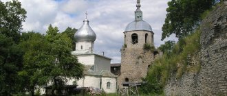
- At the beginning of the street on a hill is the Epiphany Church (consecrated in 1902). The construction and arrangement of a stone church on the site of a dilapidated wooden one was carried out with donations from merchants Vinokurov, Zorin, Pudovkin, Simonin and Chaigin. The temple was based on an exemplary design in the pseudo-Russian style, with elements of ancient Russian religious architecture. In the 1930s, the crosses were removed from the temple, and a distillery was located inside. Currently, the plant's facilities have been transferred to another building - the temple building is being restored.
- In the building of the mansion of the merchant A.S. Khomutov (Lenin St., 18), next to the church, there was a medical school until 2007. This is a two-story brick house with a basement. The façade is decorated with white brick ornaments. The building is made in eclectic forms using elements of classicism. In connection with the start of construction in 2006 of the second railway bridge across the Ob, the school moved to a new building on the street. Pushkin.
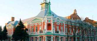
- At house number 49 on Lenin Street there is the Kamensk State Museum of Local Lore. The city museum is located in the neoclassical mansion of the Vinokurov merchants (“Vinokurovsky House”). In 1942 - 1944 the building housed the evacuated Voronezh Agricultural Institute. Since May 2008, the Vinokurov and Sons trading house has been protected by the state as an architectural monument of federal significance.
- On the corner of Lenin Street (No. 66) and Komsomolskaya there is a beautiful two-story brick house of the merchant Pudovkin with a rounded corner shape. Its architecture contains elements of early century Art Nouveau. On the second floor there are twisted wrought iron balconies and decorative elements. At the address st. Lenina, 78 is the main building of the estate of the merchant Zorin (now the Office of the Pension Fund of the Russian Federation for Kamen-on-Obi and Kamensky District), also built in the eclectic style of the early 20th century. It is also a two-story brick building with a cubic shape. On the second floor of the central facade there is a beautiful wrought-iron balcony; the windows are decorated with white brick ornaments.
- Among the modern attractions, one can note the embankment, stretching along the river bank from the street. Krasnoarmeyskaya to the city park.
Mansion of the merchant A.S. Khomutov (until 2007, the building housed the Kamensk Medical School) The main building of the estate of the merchant Zorin (now the Administration of the Pension Fund of the Russian Federation for Kamen-on-Obi and the Kamensky district) House of the merchant Pudovkin (on the 1st floor of the building the “Volna” cafe is located) Mansion of the Vinokurov merchants (the 2nd floor of the building is occupied by the Kamensky Local History Museum) Source
Sources
- https://www.altairegion22.ru/territory/regions/kamen-na-obi/
- https://turistka.ru/altai/info.php?ob=1059
- https://vyurchenko.ru/altajskij-kraj/gorod-kamen-na-obi.html
- https://dic.academic.ru/dic.nsf/ruwiki/53692
- https://mysmsbox.ru/city-code/%D0%90%D0%BB%D1%82%D0%B0%D0%B9%D1%81%D0%BA%D0%B8%D0%B9%20 %D0%BA%D1%80%D0%B0%D0%B9/%D0%9A%D0%B0%D0%BC%D0%B5%D0%BD%D1%8C-%D0%BD%D0%B0 -%D0%9E%D0%B1%D0%B8
- https://tropki.ru/rossiya/altayskiy-kray/kamen-na-obi