The Kursk region, with its center in the city of Kursk, is included in the Central Administrative Okrug. The region borders not only with regions of the Russian Federation, but also with Ukraine. The territorial unit received official status in 1934.
By Russian standards, the region is small, with a population of 1.122 million people (Rosstat data as of January 2022). There are 28 districts in the Kursk region.
Glushkovsky and Gorshechensky
The territory of Glushkovsky shares borders with Ukraine and is home to 19,503 people. There is a distillery, sugar and bread factories here. At the Glushkovo station there is an asphalt production plant, but the main economic component of the area is agriculture. The administrative center is the town of Glushkovo.
Next on the list of districts of the Kursk region is Gorshechensky, occupying 4.7% of the entire territory of the region. The center is the village of Gorshechnoye. A little over 16 thousand people live in the area. It is on this territorial unit that the Barkalovka conservation area is located in the upper reaches of the Apochka River.
General information about the Kursk region
Distinctive features
. Since the first Slavs settled in the Kursk lands, this territory has become a bone of contention between stronger neighbors. First, the Pereyaslav princes fought for it with the Chernigov princes, then the Lithuanian principality with the Horde, until Moscow liberated these lands from the Catholic Lithuanians.
Now the Kursk region continues to occupy an important strategic position. Transport routes connecting Moscow with Crimea pass through Kursk. During the Great Patriotic War, the famous Battle of Kursk took place here - a battle after which the initiative in the war forever passed to the Soviet troops.
Economic activity in the region is active, trade, transport, and the service sector are developing. But they don’t forget about traditional areas - just like decades ago, they mine iron ore, grow grain, sugar beets, and vegetables. Fortunately, the local soils are rich in black soil. Also here is one of the largest nuclear power plants - the Kursk Nuclear Power Plant.
The Kursk land has given birth to many talented and famous people. These are Saint Seraphim of Sarov, writer Arkady Gaidar, author of “Timur and His Team,” and artist Alexander Deineka, and famous humorist Vladimir Vinokur. The future General Secretary of the CPSU Central Committee, Nikita Sergeevich Khrushchev, was born in the village of Kalinovka, Kursk region, and promised to show “Kuzka’s mother” to the capitalist world. Surprisingly, the parents of another famous secretary general, Leonid Ilyich Brezhnev, also came from the Kursk lands.
Kursk is the heart of the Nightingale region. Not a city, but a song!
One of the symbols of the Kursk region is the Kursk nightingale - a unique species of songbird that can produce terli of particular beauty and complexity. Among the regional attractions, it is worth highlighting the Korennaya Hermitage Monastery, 30 km from Kursk, and noble estates, of which the most famous is the palace of the Baryatynsky princes in Maryino.
Monastery "Root Hermitage"
Geographical location
. The Kursk region is located in the west of the Russian Federation, in the central part of the East European Plain. In the north, the region borders with the Bryansk, Oryol and Lipetsk regions, in the south - with Belgorod and Voronezh, in the west - with Ukraine.
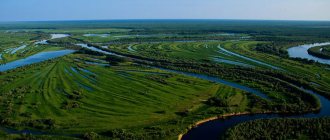
Located in the southwest of the Central Russian Upland, the Kursk region has a flat topography. The average height above sea level is 200 m. There are few reservoirs here, mostly artificial reservoirs. Of the more or less large rivers, five are worth noting: Seim, Psel, Svapa, Tuskar, Kshen.
Population.
Since the Kursk land had different masters in different historical eras, here we can find a mixture of very different dialects and even different groups of the peasant population: Sayans, Tsukans, Goryuns. The territory of the region was also actively populated by fugitive peasants, as well as migrants from the internal regions of the Russian kingdom, often sent to these lands on a voluntary-compulsory basis.
Now 96% of the region’s population are Russians, 1.3% are Ukrainians. In total, 1120 thousand people live in the Kursk region. The population is steadily declining every year: the mortality rate here is noticeably higher than the birth rate, and the flow of people wishing to move here from other regions is noticeably inferior to that of the neighboring Belgorod region. The male population is much smaller than the female population: 45.4% versus 54.6%. Population density is low: 37.3%.
Crime
. In the criminal ranking of regions, the Kursk region is in 48th place, and there is a trend towards a decrease in the number of crimes committed. There were no major or scandalous cases in this area. Mostly domestic crimes. Quite often, rape cases are featured in news reports, so parents of high school girls should teach their children to be careful. Corruption in government is also a common phenomenon.
Unemployment rate
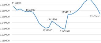
in the Kursk region does not differ much from the national average. In 2012 it amounted to 5.11% (the Russian average is 5.45%). It must be said that there are not many large enterprises in the region, such as the Mikhailovsky Mining and Processing Plant in Zheleznogorsk or the Kursk Nuclear Power Plant, where new power units are now being built to replace the spent ones. But there are many medium-sized enterprises in the processing industry, primarily involved in food production. The average salary in the Kursk region is approximately 18,000 rubles, which is the average for the central regions, not counting the capital.
Kursk NPP in Kurchatov
Property value.
Housing prices in the Kursk region are pleasantly surprising. The average cost of one square meter in Kursk is one of the lowest in the Central Federal District - 38,353 rubles. This is explained by the low popularity of this region among migrants, the decline in population and the vacancy of housing stock. On the other hand, there are no such compelling reasons to neglect this city. Most likely, the reason is that the Kursk region is not yet a popular region, and its administration is not making enough efforts to create an attractive image of its fiefdom.
Climate
Kursk region - temperate continental. The average temperature here in July is +22°C, in January -7°C. The average annual precipitation is 550-600 mm per year. Peak precipitation occurs in the warm months, with more precipitation falling in the northwest of the region. There is quite a lot of snow, and it lies steadily from December to early March. The height of the snow cover reaches 20-40 cm.
Dmitrievsky and Zheleznogorsky
Dmitrievsky has 14,854 inhabitants (the center is the city of Dmitriev), which is home to about 44.56% of the total population.
15,890 people live in Zheleznogorsk, but only 10.52% live in urban areas, in the center, the working village of Magnitny. By the way, the city of Zheleznogorsk is the administrative center, but is not part of the district.
Kastorinsky and Konyshevsky
More than 15 thousand people live in Kastorinsky, the center is the working village of Kastornoye. On the territory there are sugar and dairy factories, railway enterprises. There is a lot to see in the area, there are 16 burial mounds, the 18th-century Church of the Assumption of the Blessed Virgin Mary and holy springs.
In the Konyshevsky district of the Kursk region, the administrative center is the town of Konyshevka. There are few residents in the area - 8,744, and the administrative center accounts for almost 40%. In the area there are two churches of the 19th century, protected by law, and the monastery of Our Lady of the Sign.
History of the city of Oboyan
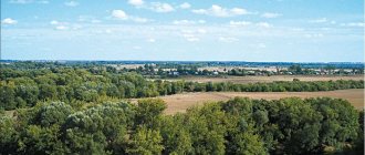
Oboyan is a city with a poetic name, located 60 kilometers south of Kursk along the Moscow-Simferopol highway. It is the regional center of the Kursk region. The city is located on a hill, bordered on both sides by the rivers Pslom and Oboyanka. From the north side there is a panorama of the city with the domes of the Trinity and Alexander Nevsky Cathedrals towering above it, and the bell tower of the old Smolensk Church. In the distance you can see a grain elevator, five-story residential buildings, and from the southern slope you can see the wide floodplain of the Psla with a bending riverbed and water meadows.
Since ancient times, the area where Oboyan is located has provided great convenience for human life. The hill, washed by the Pslom and Oboyanka rivers, surrounded by ravines and gullies, in ancient times facilitated and strengthened the defense of Russian lands from enemy attacks. The emergence of the city is associated with the defense of the southern borders of the Russian state from attacks by nomads. Robber raids took place in the 16th-17th centuries almost every year and continued until the conquest of Crimea, that is, until 1783.
Information about the founding of Oboyan is numerous and contradictory. According to some sources, the city arose in 1649, according to others in 1650, and according to others in 1651. Documents identified in the Central State Archive of Ancient Acts make it possible to establish the date of foundation of the Oboyan fortress from the raids of the Crimean Tatars. This is 1649.
On July 2, 1638, the Belgorod governor Pyotr Pozharsky sent a petition to Moscow to the Discharge Order, which said: “The Kurds and Belgorod residents, boyar children and Cossacks, and archers, and all sorts of service people are beating the pink cities with their brows. Dear sir..., perhaps, sir, we were ordered to build a city between Kursk and Belgorod in halves - from Kursk 60 versts and Belgorod 60 versts, at the mouth of the Baya River, and where it flowed into the Big Psel on the Bayan ancient settlement, from the ancient times, from the Muravskaya sakma 10 versts..."
On July 31, 1638, a decree was given: “...on that Oboyan settlement, build a residential town and service people from the children of boyars, and archers, and Cossacks, and gunners,...and arrange all sorts of land..., and write it down, and draw it on a drawing...”.
On August 16, 1649, 607 servicemen led by governor Ivan Koltovsky arrived at the mouth of the Boyan River (Old Russian name Oboyan) and began construction on the high right bank of the Psl. Already three months after the start of construction of the city, in November, the first Oboyan governor, Ivan Koltovsky, sent to Moscow a painting of 27 new villages and settlements that had appeared on the territory of the newly formed county. The lands of the county at that time extended 10-15 miles from the city.
(Variant location of the Oboyansky fort.)
According to one version, the city got its name from the Boyan River (now Oboyanka), the prefix “O” meant near the Boyan River, hence Oboyan. Sentry guards monitored the Murom Highway and gave signals in case of danger. When the enemy approached, the inhabitants of the surrounding areas took refuge under the protection of the fortress walls and garrison. In 1668, there were 759 boyar children, 77 Cossacks, 9 gunners and 9 archers in Oboyan.
The Oboyan warriors justified the then-current saying “Oboyan is a town - a corner of Moscow,” standing here guarding the southern borders of the Russian state. Service people received land plots and, at the same time as military service, were engaged in agriculture.
The servicemen transferred by the government to Oboyan founded urban settlements: Cossack, Pushkarnaya, Streletskaya. The names of the settlements indicated the type of weapons that the servicemen used. The Oboyan wooden fortress was fortified and the garrison was strengthened. People from neighboring and central districts of Russia settled around the fortress and founded villages.
Due to the retreat of the border of the Russian state further to the south, the Oboyan Fortress, having lost its significance, became dilapidated and completely collapsed. There was no trace left of her. Streltsy, gunners, and Cossacks were transferred to the category of single-dvortsev. New local government bodies emerged. Peaceful living conditions contributed to the growth of the city.
Another fact from the history of the administrative-territorial structure of the Oboyan region is also little known. During the time of Peter I, the vast Kiev province was created. It included Belgorod, Belevsk, Bryansk, Karachevsk, Kiev, Kursk, Liven, Oryol, Sevsk, Stary Oskol and Oboyan provinces. These are the vast territories the Oboyan land was listed on the same level with! True, the Oboyan province existed for a relatively short period by historical standards - from 1712 to 1719. Later it was abolished and the city of Oboyan and its surrounding area, already as Oboyansky district, became part of the Belgorod province (1727-1779). By decree of May 23, 1779, Oboyan was designated a district town of the Kursk governorship. On December 31, 1796, with the new division of Russia into provinces, Oboyan and the district became part of the newly formed Kursk province.
The city has its own coat of arms, approved on January 8, 1780: “In the upper part is the coat of arms of Kursk. In the second part of the shield, an animal called a ferret is in a golden field, for the reason that many of them are caught in the vicinity of this city.”
The Oboyan land is rich in historical events. The most significant of them is the following. In June 1787, Empress Catherine II passed through the city, returning from a trip to the Dnieper and Crimea. At the entrance to Oboyan on the eastern outskirts, in honor of her arrival, two stone pillars were erected, popularly called “slingshots”.
According to the plan of 1784, it was planned to build 5 blocks with stone buildings and 29 with wood. In 1790, a stone church was built in the name of the Smolensk Icon of the Mother of God with a round low dome. Before the construction of the two Cathedrals, it was the most spacious in the city. The construction and development of the city continued. So by 1805 there were already 540 philistine houses in Oboyan. New straight streets were created, where stone houses appeared, standing out against the background of wooden buildings. A district school was opened in 1812, and a parish school in 1836. When talking about the development of the city, one cannot ignore the church in the Kozatskaya settlement. In 1784, a wooden church in the name of the holy prophet Elijah began to operate on the territory of Oboyan. Nowadays, the three-altar stone St. Elias Church, built in 1841, rises above freedom. At the same time, the first handicraft factories began to appear, and the number of merchants increased significantly. Oboyan developed as a trading city, which was facilitated by its position on the Moscow-Kharkov highway.
Two-story stone buildings with beautiful facades, gates, large trading floors, and good basements began to appear in the city. One-story stone houses also appeared in freedom. In 1882, a railway line with a length of 29.3 versts connected the city of Oboyan with the Rzhava station of the Kursk-Kharkov-Azov railway.
In 1891, with private donations, construction began on a five-domed, three-altar warm cathedral in the name of the blessed Prince Alexander Nevsky. At the same time, construction of the Trinity Cathedral was underway. Currently, renovated and restored cathedrals and the Smolensk Church decorate our city even more and give it the charm of antiquity. All of these temples are protected as cultural and architectural monuments of regional significance.
In 1892, a girls' gymnasium was opened.
A little later, parochial schools began to appear in the city one after another, later renamed Oboyansk secondary school No. 1, Oboyansk secondary school No. 2, Oboyansk secondary school No. 3.
In the last pre-revolutionary year of 1916, the following were operating in Oboyan: a steam oil mill, 4 windmills, 3 chenille factories, 2 tanneries, a mead factory, a wax factory, and a lard factory.
The city square, which was called Red Square, and now the square named after
V. Petrova, was a huge place for trading and was built up with shops and stores.
Oboyan was one of the merchant cities. Merchants were actively involved in charity work, which had a positive effect on the development of the city. Solid houses and trading shops were built. The following have been preserved and are protected as monuments of cultural heritage: the house of the merchant Razinkin (Dzerzhinsky St., 11), the confectioner Zubkov (Dzerzhinsky St., 25), the building of the inn of the Cheburashkin merchants (Kooperativnaya St., 3), the residential house of the merchant Abakumov (Lenin St. , 3), the building of leather warehouses (Lenin St., 14) and the Abakumov hotel (Lenin St., 23). And now our little glorious Oboyan continues to develop as a trading city. There are two markets on its territory: New and Central. Fairs are organized regularly.
In the period from 1924 to 1928. Oboyansky district was abolished. The city of Oboyan has become secondary, i.e. ceased to be a regional center.
The residents of Oboyan faced many trials. During the Great Patriotic War, Oboyans joined the Red Army. For security
battalions were created in the city - fighter and people's militia.
On November 11, 1941, Oboyan was occupied by the Nazi invaders. Hard and dark days have come.
In orders from the German command, the death penalty was often mentioned. Trees and telegraph poles along Lenin Street often became gallows. People were shot in the ravines on the eastern outskirts of the city. They also killed in the basement of one of the buildings of the Oboyan Agrarian College, and upstairs in the casino Nazi officers were having fun. The occupiers forced the population to do hard work and deported them to Germany. The inhabitants of the city did not submit to the enemy. They sheltered the wounded who were surrounded and resisted.
During the Great Patriotic War, battles for Oboyan and the region took place twice in order to liberate them from the Nazi invaders: in January 1941 and February 1943. The liberation of Oboyan was entrusted to units of the 303rd Siberian Rifle Division, Colonel K.S. Fedorovsky, after whom one of the streets of the city is named. Fearing complete encirclement and defeat, on the night of February 18, having blown up the bridge over the Psel River and part of the city buildings, under the cover of barriers, the main enemy forces retreated to Sumy. On February 19, 1943, the city was completely liberated from the Nazi occupiers.
Thousands of residents of the city and region fought on its fronts during the harsh years of the Great Patriotic War. Many of them were awarded orders and medals.
After liberation, restoration work began. Despite the damage caused, the city of Oboyan quickly healed the wounds left by the war. By the end of 1945, the power plant, cinema, House of Culture, library college, teacher training college, secondary school, and part of the residential buildings were restored.
The post-war development of the city was also affected by the presence of a considerable number of industrial enterprises. In 1947, construction began on the eastern outskirts of the city, which became the largest enterprise in Oboyan. In 1948, the Oboyansky elevator was created - one of the largest elevators in the country. The Moscow-Simferopol asphalted transport highway runs through the central streets of Lenin and Lunacharsky. Reinforced concrete bridges were built across the Psel and Oboyanka rivers. Buses started running.
The construction industry has been represented for decades by the organization Remstroy LLC, which is engaged in the construction of residential and non-residential buildings.
Since the early 30s of the last century, a drying plant was operating on the territory of Oboyan, processing fruits and vegetables. In the early 2000s, due to a number of reasons, the plant practically ceased to exist for several years. Since 2008, the plant has resumed its work, developing and conquering new markets. The products of factories and enterprises located in the city are known far beyond the borders of the Kursk region.
Since the beginning of 2000, small and medium-sized businesses began to develop in the city. Prominent representatives of such organizations were: Aquaton LLC, Vostok LLC, Tekhnolog LLC. Another large enterprise is located on the territory of Oboyan - Artel JSC. The cultural and leisure sphere of city life is also widely and diversely represented: the district House of Folk Art (showing films in 3D format since 2016), the House of Pioneers and Schoolchildren, the Oboyan School of Arts, the Oboyan branch of the Kursk Museum of Local Lore, three libraries for adults and youth, one children's library. For sports lovers, there is a children's sports school for youth in the city.
The total number of residents in the city according to the first general census in 1897 was 11,872 people, and at the beginning of 2022 - 13,413 people. Over the past decades, housing, communal construction, and landscaping have undergone significant development in Oboyan.
A significant amount of residential space has been put into operation.
According to the list of cultural heritage sites of regional significance (as of June 1, 2018), the following cultural heritage sites are located in the city:
1. mass grave of soldiers of the Soviet Army who died during the Great Patriotic War (Mirnaya St., 50, west of secondary school No. 3);
2. the place where the Bolsheviks were executed by Denikin in 1919 (Lunacharsky St., block No. 87);
3. mass grave of young partisans: Kholyavkin, Dolzhenkov and Zvyagintsev, executed by the Nazi invaders in 1942 (city cemetery);
4. mass grave of soldiers of the Soviet Army who died in February 1943 (Young Pioneers Park);
5. an airplane installed in honor of Soviet pilots who died in battles with the fascist invaders (Kurskaya St., block No. 9).
The city of Oboyan is the administrative, economic and cultural center of the region.
Kursk
The Kursk district of the Kursk region is the largest, with a population of 57,692 people. In the area on the right bank of the Rat River there is an ancient Slavic settlement dating back to the 9th-14th centuries.
The head of the administration of the Kursk district of the Kursk region today is V.M. Ryzhikov.
The structure includes 17 village councils of the Kursk district of the Kursk region.
see also
- Kursk region
- Cities of Russia
| [ + ] Cities by regions of Russia | |
| Cities of the North-West (NWFD) | St. Petersburg (and its cities) • Leningrad region (historical Staraya Ladoga) • Arkhangelsk region • Vologda region • Kaliningrad region • Karelia • Komi • Murmansk region • Nenets Autonomous Okrug • Pskov region |
| Cities of the Volga region (Volga Federal District) | Bashkortostan • Volgograd region • Kalmykia • Kirov region • Mari El • Mordovia • Nizhny Novgorod region • Orenburg region • Penza region • Perm region • Samara region • Saratov region • Tatarstan • Udmurtia • Ulyanovsk region • Chuvashia |
| Cities of Southern Russia (SFD) | Sevastopol (including Inkerman) • Republic of Crimea • Adygea • Astrakhan region • Krasnodar region • Rostov region |
| Cities of the North Caucasus (NCFD) | Dagestan • Ingushetia • Kabardino-Balkaria • Karachay-Cherkessia • North Ossetia - Alania • Stavropol Territory • Chechen Republic |
| Cities of the Urals (Ural Federal District) | Kurgan region • Sverdlovsk region • Tyumen region • Khanty-Mansi Autonomous Okrug - Yugra • Chelyabinsk region • Yamalo-Nenets Autonomous Okrug |
| Cities of Siberia (Siberian Federal District) | Altai Republic • Altai Territory • Irkutsk Region • Kemerovo Region • Krasnoyarsk Region • Novgorod Region • Novosibirsk Region • Omsk Region • Tomsk Region • Tyva • Khakassia |
| Cities of the Far East (FEFD) | Amur Region • Buryatia • Jewish Autonomous Region • Trans-Baikal Territory • Kamchatka Territory • Magadan Region • Primorsky Territory • Sakha (Yakutia) • Sakhalin Region • Khabarovsk Territory • Chukotka Autonomous Region |
| see also | Cities of the DPR, LPR, Transnistria, South Ossetia • Regions of Russia • Cities of Russia |
Ponyrovsky and Pristensky, Rylsky and Sovetsky
Almost 11 thousand people live in Ponyrovsky, the center is the town of Ponyri.
Pristensky has a population of 15.5 thousand inhabitants, the center is the town of Pristen. In the village of Kirovsky there is a museum “Command Post of the Voronezh Front”.
The Rila municipality has a population of 31,609. The center is the city of Rylsk. In the center of the village of Kapystich there is a settlement, excavations of which revealed that the settlement was founded back in the 9th and 11th centuries.
17 thousand people live in the Sovetsky district, the center is the town of Pshensky.
Solntsevsky and Sudzhansky
In the Solntsevo district, the center is the town of Solntsevo, the total number of residents of the municipal unit is 13,733. In the village of Orlyanka there is a church built in 1794.
In Sudzhansky (26,773 people), the center is the city of Sudzha. There are many industrial enterprises and 2 chalk developments. In the village of Gusevo there is the estate of P.D. Dolgorukov, and in the village of Gornal there is a large settlement.