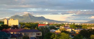
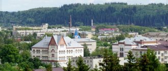
Yoshkar-Ola is the capital of the Mari El Republic. The city was founded at the end of the 16th century on the banks of the Malaya Kokshaga River. Some residents of the country do not know where Yoshkar Ola is located. It is located in the Mari Lowland, near the taiga zone.
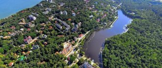
The city's climate is characterized by cold winters, but also warm summers. The city has the Malaya Kokshaga River. She divides it into two parts.
Diversity of Nationalities
As for the ethnic composition of the city, it has 96 different peoples. The majority of the population in the territory is Russian - 68%. Next come the indigenous Mari - 24%. The third place in number is occupied by the Tatar peoples - 4.3%. In addition to the main national composition, the urban population of Yoshkar-Ola consists of:
- Chuvash;
- Ukrainians;
- Azerbaijanis;
- Armenians;
- Uzbeks;
- Belarusians;
- Udmurts;
- Georgians;
- Germans and many others.
Train Station
The Yoshkar-Ola railway station is a station in the Kazan region of the Gorky Russian Railways, which is located on the 106th km of the Zeleny Dol - Yaransk section. The number of platforms is 2, the number of departure tracks is 10. The railway station is located at st. Yanalova, 3. The railway station building houses a spacious waiting room, ticket offices, and storage room for luggage and personal belongings. There is also a medical center and a cafe at the station.
A long-distance train departs from the Yoshkar-Ola railway station in the direction Yoshkar-Ola - Moscow. Suburban trains that go to Kazan and Tabashino are also serviced.
Districts of Yoshkar-Ola
By tracking the growth of the territory of Yoshkar-Ola on the map, you can see that over the years 20 nearby villages and suburbs were annexed to the capital of Mari El.
The district of the city, in addition to Yoshkar-Ola, consists of the following settlements: the settlement of Apshakbelyak, the village of Semyonovka, the villages of Ignatyevo, Nolka, Danilovo, Savino, as well as Shoya-Kuznetsovo, the village of Akshubino, the village of Yakimovo, the village of Kelmakovo.
The following microdistricts are identified in the urban area: Berezovo, Alyonkino, Bolshoye, Bolnichny, Vostochny, Chigashevo, Dubki, Gomzovo, Zvezdny, Integral, Mashinostroitel, Leninsky, Molodezhny, Mirny, Nagorny, Myshino, Nikitkino, Orshansky, Oktyabrsky, Pribrezhny, Prezavodskoy, Sverdlova , Repair Plant, Soviet, Northern, Sports, Szombathely, Central.
The division of the city into districts began in the 20th century. In the 70s, Yoshkar-Ola on the map was actually divided into 2 districts: Zavodskoy and Leninsky, which included residential areas as well as rural areas.
The factory urban district united: Sidorovsky village council of the Medvedevsky district, Kokshaysky (the village of Kokshaysk and the suburban village council, which was later abolished).
Leninsky district consisted of several village councils: Kuyarsky, Solnechny, Kundyshsky and Semenovsky.
Natural areas and reserves of the city of Yoshkar-Ola
In the area where Yoshkar Ola is located, there are a large number of environmental sites. For example, nature lovers should visit the Botanical Garden of the State University.
This garden is a reserve in which rare plants grow, many of which are listed in the Red Book. It is curious that over thousands of plant species grow in such a garden.
Be sure to visit the pine grove within the city. It has a fairly impressive area - over four hundred hectares. Centuries-old pines are very valuable. Their average age reaches two centuries. And the oak grove is located in the southern part of the city.
Despite the fact that its area is somewhat smaller and has been somewhat modified by human activity, it is still of great value for nature lovers. Many species of valuable and rare trees grow here.
Bruges waterfront
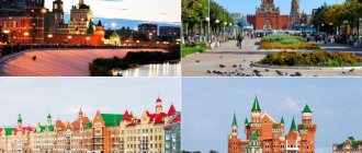
One of the most beautiful streets of Yoshkar-Ola is the Bruges Embankment. This most picturesque place in the city is located on the banks of the local Kokshaga River. This “piece of Belgium” is recreated based on the Belgian architecture of the city of Bruges. A real decoration of the embankment are the houses lined up along the entire street with colored roofs, windows of different sizes, tubes and turrets.
The opening of the Bruges Quay took place in 2010.
Other city attractions
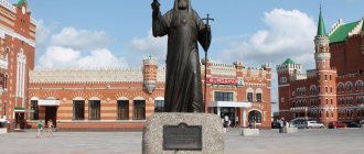
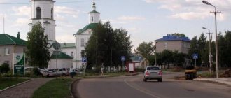
The area where Yoshkar Ola is located is unique in many ways. If this is your first time in this wonderful city, be sure to visit Nogotkov-Obolensky Square. This is one of the most interesting places in the ancient city. There is a monument to the governor of Tsarevokokshaisk (that’s what this city was once called).
The square is named after him. Near the monument is an exact copy of the capital’s Tsar Cannon. An art gallery is located on the same square. It is not as big as in the capital, but still the largest in the city.
But in Arkhangelskaya Sloboda there is a monument to a big, big cat, which nobly arched its back. And near the agricultural ministry of the republic, a shelter and a calf are grazing. This is “Ode to the Russian Burenka”. And at the University of Mari there is... Yoshkin's cat - a favorite vacation spot for students.
Yoshkin cat
The area where Yoshkar Ola is located is full of the most unexpected and unusual places worth visiting. To have time to visit this city, satellite-controlled chimes will come to the rescue. The city is looking forward to guests and is ready to open up to each of them.
Short story
The birth of the city of Yoshkar-Ola is associated with the largest event in the history of the Mari region - the entry of the Mari people into the Russian state in the middle of the 16th century, after the defeat of the Kazan Khanate. It was founded as a fortress in 1584 by order of Tsar Fyodor Ioannovich, in the dense, impassable forests and swamps of the low-lying left bank of the Volga, on its tributary, Malaya Kokshaga. Initially, the fortress was known as Kokshazhsk, later - Kokshatsky town, and then - Tsarevokokshaysk.
Since 1708 the city has been part of the Kazan province, and since 1781 it has been a district town of the Kazan governorship. The Tsar's city on Kokshaga remained wooden for a long time. At the end of the 19th century, in the city, which in appearance resembled a village, there were 6 churches (including 5 stone ones), a convent (founded in 1890), and there were 186 wooden and 8 stone houses. A distillery and tannery operated.
In 1919, the city of Tsarevokokshaysk was renamed Krasnokokshaysk, and in 1928 - Yoshkar-Ola, which means, translated from Mari, Red City. From 1936 to 1990, Yoshkar-Ola was the capital of the Mari Autonomous Soviet Socialist Republic, and currently the capital of the Mari El Republic.
The city of Yoshkar-Ola is located on the Mari Lowland, 50 km north of the Volga, on its left tributary - the river. Malaya Kokshaga. The climate is moderate continental. Average temperatures in January are -13°C, in July 19°C. Precipitation up to 500 mm per year
The municipal entity “City of Yoshkar-Ola” is located in the center of the Mari El Republic and 862 km from Moscow. This is a complex administrative-territorial unit. Yoshkar-Ola is not only a city of republican significance, with a 420-year-old
history and being the capital of the Republic of Mari El. Its historical feature is that the city at different times included more than 20 surrounding villages. In addition, the municipality covers a number of settlements,
subordinate to the Administration of Yoshkar-Ola, and not only directly adjacent to the city, but often located at a considerable distance from it. These are Sidorovsky (center - Nolka village), Semenovsky (center - Semenovka village), Kundyshsky (center - village
Silikatny), Kuyarskoye (center - Kuyar village) and Kokshaysky (center - Kokshaysk village) village councils. Therefore, the geographical location of the municipal formation “City of Yoshkar-Ola” is peculiar and unusual. It is surrounded on all sides by the lands of the Medvedevsky district, and on
in the south it wedges into the territory of the Zvenigovsky district and comes out on the banks of the Volga. Water meadows and partly farmland and forests approach the city from the north, farmland from the west and northwest, and forests in the southeast, south, and southwest of the city.
arrays. Settlements located near the Kokshay tract are surrounded by forests of the State Forest Fund.
The territory of Yoshkar-Ola, together with the rural settlements assigned to it, is 110 square meters. km, including urban land itself - 56 sq. km, the rest is arable land, urban forests, hayfields and pastures, gardens and country houses
cooperatives. The city of Yoshkar-Ola is not only surrounded by green forests on almost all sides, but also has fairly developed “lungs”. City parks, squares and other green spaces occupy more than 1,600 hectares, of which 801 hectares are urban forests (Pine Grove, Oak
grove, etc.), for which the status of specially protected natural areas has been introduced.
According to the results of the 2002 All-Russian Census, the population of the city, together with its subordinate rural administrations, is 281.1 thousand people.
The city of Yoshkar-Ola is located in the center of the Mari Lowland, in an area of mixed forests, actually on the southern border of the taiga zone. The Malaya Kokshaga River, a tributary of the Volga, flows through the city. Within the boundaries of the municipality, the Oshla rivers flow into it,
Managa, Maly Kundysh, Nolka. The southern border of the municipality is the left bank of the Volga and the mouth of the Bolshaya Kokshaga flowing from the virgin forests. On its territory there are the most beautiful lakes Tair, Karas, Shap and others. All this creates favorable
recreational opportunities for citizens and residents of other regions of Russia.
The administrative-territorial structure of Yoshkar-Ola and its environs developed historically over a long period of time. We can trace this process back into history until the middle of the 16th century.
As part of the Kazan Khanate, the Mari did not have cities; they lived in small settlements - “ilems”. The area of present-day Yoshkar-Ola and its environs was part of the Galician Daruga of the Khanate. It is not known which settlement was its administrative center, but most likely it was located closer to the capital of the khanate. At that time, the territory of modern Yoshkar-Ola and its environs was the northern periphery of the Kazan Khanate, through which trade, economic and military-political ties were carried out between Kazan and the northeastern Russian lands. In particular, it is known that this area was crossed by the Galician Road, which ran northwest from Kazan towards the city of Galich, an important medieval city in northeastern Rus'.
After joining the Moscow state in the second half of the 16th century, the administrative-territorial structure and management system characteristic of Russian lands were introduced here. Before the construction of Russian fortified cities on the Mari lands, the entire territory of the left bank of the Volga was under the control of the Kazan governor. The cities of Kokshaysk (1574) and Tsarevokokshaysk (1584), which were then founded here, had their own districts with a tax-paying (yasak) population and, among the “lower cities”, until the beginning of the 18th century, were directly subordinate to Moscow, the Order of the Kazan Palace.
When Peter I divided Russia into provinces in 1709, Tsarevokokshaisk and Kokshaisk with their districts were included in the Kazan province. And in 1719, when it was divided into provinces, these cities and counties ended up in the Sviyazhsk province.
Devastating fires, unfavorable economic conditions and social upheavals of the 18th century reduced the city of Kokshaysk to the status of a rural settlement of Tsarevokokshaysky district, which was determined already in 1765, when the Kazan governor, based on the general instructions of Empress Catherine II on the consolidation of districts, ordered to “attribute” Kokshaysk and the left bank part of his district to Tsarevokokshaisk and deprive it of city status. Thus administratively the destinies of the two were united
settlements. True, in 1904 the village of Kokshayskoye and surrounding villages were transferred to the Cheboksary district and with the formation of the Mari and Chuvash Autonomous Regions in 1920, Kokshaysk first became part of the latter, but in 1925 it was transferred to the Mari Autonomous Region, and thus , the fates of the two ancient cities were united again.
And the history of Russian villages that appeared near Tsarevokokshaisk immediately after its foundation and later on lands liberated from the local Mari population through eviction, was always directly and firmly connected with the history of the city. When
suburban settlements of Russian peasants became the property of the royal family, historians were unable to find out, but in the 17th century they were palace settlements. They were united into the Palace volost (in some documents - the Palace Country volost). Since 1797 there was
The Department of Appanages was created, accordingly, the palace peasants began to be called appanages, the Tsarevokokshay palace volost was renamed the Varaksa appanage expedition, then the Varaksa appanage order. In 1863, appanage peasants were
freed from serfdom in relation to the royal palace. Their villages made up the Varaksinsky volost. At the beginning of the twentieth century, it consisted of 23 villages, 17 of which are currently either streets of the city of Yoshkar-Ola, or are located in
administrative subordination of the municipal formation "City of Yoshkar-Ola".
As for the surrounding Mari population, they had the right to live at a distance of at least five miles from the city walls. But the influence of the city also extended to him. This was expressed not only in the payment of yasak and other duties in the city, but also in
the policy of Christianization, which over time was reflected in administrative and managerial relationships. The nearest Mari villages were part of the Nolinskaya volost; their inhabitants were already converted to Christianity in the 17th century (and perhaps already at the end of the 16th century).
faith and united into a special Podgorodny Novokreschenskaya volost. Subsequently, they belonged to the larger Arban volost. In particular, these were Bolshoye Chigashevo and Maloe Chigashevo, Chikhaidarovo, Alenkino, which are now part of the city. In contrast
from the nearest Russian palace (appanage) villages, the Mari residents were yasak (from the time of Peter the Great - state), that is, they belonged to the feudal state as a whole. Like neighboring Russian villages, they were attached to city churches.
Tsarevokokshay district was initially small in area and population. According to Catherine’s reform of 1781, it increased not only due to the former city of Kokshaysk and two Trans-Volga (left bank) volosts of the former Kokshay district, but
and due to significant territories transferred from Kazan and Tsarevosanchur districts.
In this form, it remained as part of the Kazan province for a long time, specifically until the revolutionary upheavals of the early twentieth century, and even more precisely until 1920. When the Tatar ASSR was formed in May 1920 with
capital in the city of Kazan, the Kazan province was disbanded. At the same time, Krasnokokshaysky (formerly Tsarevokokshaysky) district without two south-eastern volosts inhabited by Tatars was temporarily transferred to the Vyatka province.
On November 4, 1920, the Mari Autonomous Region was proclaimed by decree of the All-Russian Central Executive Committee and the Council of People's Commissars of the RSFSR. On November 25, the All-Russian Central Executive Committee and the Council of People's Commissars adopted a new decree, according to which the territory was determined
region: Krasnokokshaysky district of the Vyatka province became entirely part of the Mari Autonomous Region, and the city of Krasnokokshaysk was declared the center of the new administrative unit.
By the decision of the Revolutionary Committee of the MAO of January 15, 1921, the Krasnokokshaysky district was renamed into a canton with the same name, with the annexation of the volosts that separated from the Yaransky district of the Vyatka province, and the volosts (including suburban ones - Varaksinskaya,
Petrikovskaya, Arbanskaya and others) remained in the same form for a long time; rural societies (communities) were also preserved - mainly to resolve issues of land use and land management, and for more convenient operational management
The volosts were divided into village councils (selsoviet).
In 1924, a new administrative-territorial structure was introduced in the Mari Autonomous Region. The Krasnokokshaysky canton was disaggregated, the Morkinsky and Orsha cantons were separated from it. The volosts as a legacy of tsarism were abolished and
The village councils (near the city - Koryakovsky, Bolshechigashevsky and others) became the lowest basic administrative units.
The construction of the Zeleny Dol - Krasnokokshaysk railway was of great importance for the formation of the settlement appearance of the modern municipal formation “City of Yoshkar-Ola” (as well as for the Volzhsky and Zvenigovsky districts). It is in the process
This led to the formation of the villages of Kuyar, Surok, Silikatny, Kundysh, and Pemba.
In January 1928, Krasnokokshaysk received the Mari national name - Yoshkar-Ola (Red City), and the canton began to be called Yoshkar-Olinsky, and since 1932 the cantons were renamed into districts. Although to manage the affairs of the city directly in
In 1927, the city council was formed; it was essentially in the position of a village council, that is, it was subordinate to the canton (then district) council. District institutions, although they were called Yoshkar-Ola, were located not in the city itself, but in a suburban village
Nechaevka, which was then included in the boundaries of Yoshkar-Ola.
In connection with the transformation of the Mari Autonomous Region into the Mari Autonomous Soviet Socialist Republic in December 1936, the city of Yoshkar-Ola became its capital.
Carrying out capital functions (first as the administrative center of the autonomous region, and then formally and legally called the capital of the autonomous republic), Yoshkar-Ola expanded its borders - first at the expense of free urban lands,
but over time this turned out to be not enough. “Free” lands were at the disposal of villages in which collective farms were formed in the early 1930s. Although in 1935-1936 they received state acts for the “eternal use” of the eternally mastered
their lands, all land in the Soviet state since 1917 was declared state property, and state bodies could dispose of it at their own discretion. Certain difficulty for republican and city authorities to use
for urban buildings of the surrounding collective farm lands was represented by the fact that they were part of the district. Therefore, in the second half of the 30s, many surrounding villages (Varaksino, Koryakovo, Nechaevka, Lapshino, Markovo, Zhukovo, Shiryaykovo and Pakhomovo) were
included within the city limits. Now the seizure of land for urban buildings became easier, and this practice was continued during the war years and after.
During the Great Patriotic War, it was decided that the Yoshkar-Olinsky district was too large in territory compared to many other districts and cumbersome to manage. In December 1943, the Medvedevsky district was separated from it, which included a number of
settlements currently subordinate to Yoshkar-Ola. The remaining part continued to be called the Yoshkar-Ola district, and district institutions were still located in the village of Nechaevka, which became a continuation of the Kommunisticheskaya Yoshkar-Ola street. IN
In 1946, district institutions were transferred to the village of Semenovka, and the district began to be called Semenovsky (existed until 1959 and was merged with the Medvedevsky district).
In the post-war years, Yoshkar-Ola was built up intensively in the western and southern directions, and then in the Zarechnaya part to the southeast, reshaping the existing grid of suburban and intra-city villages.
In the drawings of new city streets and blocks drawn by architects, there was no place for them, and they either disappeared completely (like, for example, the village of Koryakovo, which in the last years before its disappearance was called Kolkhoznaya Street), or from them
scattered, torn fragments remained (for example, the village of Lapshino, which at one time bore the name of Papanin Street, later named after Olga Tikhomirova).
In the 60s-70s, a line was consistently pursued for the growth of Yoshkar-Ola through the transfer of nearby settlements under its management. The airport village, Semenovsky, Kuyarsky, Kundyshsky, Kokshaysky were transferred to the Yoshkar-Ola City Executive Committee
village councils, from the Bolshechigashevsky village council the Prigorodny village council was separated and given to the city, consisting of the village of Bolshoye Chigashevo itself, the villages of Nolka and Svetly.
By decree of the Presidium of the Supreme Soviet of the RSFSR dated December 27, 1973, Yoshkar-Ola was divided into two districts: Leninsky and Zavodskoy. In addition to the city blocks themselves, they included rural settlements: in the first - Kundyshsky, Kuyarsky,
Semenovsky, Solnechny village councils, in the second - Kokshaysky and Prigorodny village councils (soon abolished), then the Sidorovsky village council of the Medvedevsky district was included here. The regional division of Yoshkar-Ola was abolished on August 16, 1988, but rural
the settlements remained part of the city.
The most significant of the subsequent changes in the relationship between the city and surrounding rural settlements were determined by the Decree of the Presidium of the Supreme Council of the Republic of Mari El dated October 14, 1993 “On establishing the border
between the city of Yoshkar-Ola and the Medvedevsky district of the Republic of Mari El", on the basis of which the villages of Alenkino, Myshino, Tarkhanovo, which were transferred to the city not long before, and Bolshoye Chigashevo, which entered the city limits relatively long ago, were
By decree of the mayor of the city, they were renamed into streets while maintaining their previous names, and the village of Rabochiy became a continuation of Mashinostroiteley Street.
In this book, essays about settlements that disappeared due to the expansion of Yoshkar-Ola or became city streets, or were subordinated to a municipal entity, were written taking into account these circumstances.
Program for the holiday on August 11
Lenin Square
12:00 - grand opening of the holiday 13:00 - concert of the Palace of Culture named after the 30th anniversary of the Victory, display of clothing collections “Stylized Mari costume “Golden Thread”; “We are the youth of Russia”
Obolensky-Nogotkov Square
17:00 - honoring honorary citizens of the city of Yoshkar-Ola 17:30 - operetta ball "Viennese Waltz"
Chavaina Boulevard
10:00 — exhibition and sale of arts and crafts products “City of Masters” 11:00 — “Boulevard of Intellectual Entertainment”
Nikonov Square
14:00 - children's drawing competition on asphalt 14:30 - concert and game program of the studio "Zvukograd" and the theater of games and fun "Wrappers-Bows" 16:00 - concert of the vocal studio "Consonance of Hearts" "I sing to you, my Yoshkar-Ola » 18:00 - concert of the Honored Artist of the Republic of Mari El S. Osipova, G. Vasiliev, R. Yakupova 18:55 - flash mob of the anthem of the city of Yoshkar-Ola 19:00 - performance by Mari, Tatar, Russian pop artists 21:30 - folk concert artist Mikhail Mosunov
The area in front of the Palace of Culture named after the XXX anniversary of the Victory
12:00 - concert of the Russian Literary Club, the association "Harmony", the poetry club "Pegasus", the studio "Consonance of Hearts" 13:30 - folk festival "Sing ditties more cheerfully"
Central Park of Culture and Leisure. Open stage
11:00 - children's play performances and competitions 13.30 - concert and entertainment program "City Gatherings" 17:00 - brass band concert, dancing 19:00 - concert of bard song
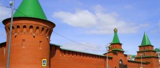
Tsarevokokshay Kremlin
8:30 — XXXVI Yoshkar-Ola Half Marathon 14:00 — concert “I Love you, Yoshkar-Ola”
Victory Park
14:00 - demonstration performances, master classes on table tennis, chess, BMX 15:00 - demonstration performances in workout 16:00 - game for children “Tubs and Watermelons”
The area in front of the Lenin Palace of Culture
17:00 — game entertainment program for the whole family “Time of Joyful Ideas” 18:00 — folk festivals “We don’t know the city better, we feel it with our souls” 20:00 — retro disco “In the Circle of Friends”
Palace of Culture of the Russian Army
10:00 — children's program, exhibition of children's drawings “Summer of My Dreams”; photo exhibition “Festive Yoshkar-Ola”
The area in front of the DKRA
11:00 — concert “Dance and sing, my Yoshkar-Ola!”
Museum of the History of the City of Yoshkar-Ola
10:00 — walking tours; educational and entertaining quest game, mobile planetarium, photo quest around the city, games and excursions through the halls of the museum
Venue of the Republican Puppet Theater
10:00 — IX stage of the World Sound Pressure Championship
Patriarchal Square
10:00 — operation of entertainment venues and attractions
10:00–22:00 — the first festival of street food and drinks, a concert program of artists from the city and the republic, a show at the Byzantium fitness club, open air with DOPPEL Perz
21:00 — concert by Natasha Koroleva
Water area of the Malaya Kokshaga River
22:00 - fireworks
4.2. Population
The Republic of Mari El accounts for 0.5% of the country's population and 2.3% of the population of the Volga Federal District.
As of January 1, 2022, the population of the republic was 684.7 thousand people, the total population density was 30.6 people/km2, and the rural population density was 10.0 people/km2.
Note: population density is given by settlements (rural and urban) and urban districts.
Population density and population density of settlements
65.8% of the republic’s population lives in urban settlements, 34.2% lives in rural settlements.
Population dynamics
As of January 1, 2022, there were 4 cities in the republic (3 cities of republican significance (urban districts) - Yoshkar-Ola, Volzhsk and Kozmodemyansk, and 1 city of regional significance - Zvenigovo), 15 urban-type settlements (Kilemary, Krasnogorsky, Krasnooktyabrsky , Kuzhener, Mari-Turek, Medvedevo, Morki, New Toryal, Orshanka, Paranga, Privolzhsky, Sernur, Sovetsky, Suslonger, Yurino) and 1596 rural settlements.
Urban population share
In terms of gender composition, women predominate in the population of the republic - 53.4%. According to statistics, more boys are born, but by the age of 35-39 the number of sexes levels off and then with age the female population predominates. The sex-age pyramid clearly shows small generations (through 25-year periods) associated with human losses and low birth rates during the Great Patriotic War; this process was aggravated by the crisis of the mid-90s of the 20th century.
Sex and age population pyramid of the Republic of Mari El (as of January 1, 2022)
The increase in the birth rate in the last decade was associated primarily with natural causes - with an increase in the size of the generation aged 22-27 years.
Dynamics of natural population movement
Fertility
Mortality
Migration processes over the last decade have been steadily dominated by population outflow: migration loss averages 1.5-2 thousand people. in year.
In the republic, as in Russia as a whole, the trend of population aging, characteristic of European countries, continues: according to the results of the 2010 population census, the average age of residents of the Mari El Republic was 38.5 years (in 2002 - 37 years) - for comparison in Russia these figures were 39 years and 37.7 years, respectively.
The share of the population under working age (children and adolescents from 0 to 15 years) as of January 1, 2022 was 19.5%, the share of the working population (men aged 16-59 years, women - 16-54 years) – 55.7 %, the share of the population over working age is 24.8%.
Dynamics of the share of individual age groups of the population
Age composition of the population
The dependency ratio (the ratio of the number of children and elderly people to the number of people of working age (per 1000 people)) on average for the republic is 795, which is slightly higher than the average for Russia (764), while in the Yurinsky district this figure exceeds 1000.
Coat of arms
The coat of arms of Yoshkar-Ola is presented in the form of a French shield. It is crowned with a golden tower crown with five teeth, with a national Mari ornament in a hoop. A silver elk is depicted on an azure background. The animal, facing the viewer's left, has golden horns and hooves. Precious metal symbolizes wealth, nobility, and prosperity. The artiodactyl embodies strength and power.
The coat of arms was approved by the decision of the meeting of deputies of the city district of the fifth convocation dated June 22, 2011 No. 286-V.
Automobile highways
Federal highways pass through Yoshkar-Ola:
- P176 “Vyatka” is a federal highway. The total length of the route is 872 km. The road originates in Cheboksary and passes through Yaransk, Kotelnich, Yoshkar-Ola. The final point of route P176 is the city of Syktyvkar. The road surface of the route is asphalt concrete.
- A295 is a federal highway with a total length of 126 km. The road starts in Yoshkar-Ola and passes through Zelenodolsk and Volzhsk. The end of route A-295 is the M-7 Volga highway.