For other uses, see Taiga (disambiguation).
City in Kemerovo region, Russia
| Taiga Taiga | |
| Town[1] | |
| Former shop of merchant Magazov (1906, architect Lygin) | |
| Flag Coat of arms | |
| Location of Taiga | |
| Taiga Location of Taiga Show map of Russia Taiga Taiga (Kemerovo region) Show map of Kemerovo region | |
| Coordinates: 56°04′N 85°37'E / 56.067°N W. 85.617°E / 56.067; 85.617Coordinates: 56°04′N 85°37'E / 56.067°N W. 85.617°E / 56.067; 85.617 | |
| A country | Russia |
| Federal subject | Kemerovo region[2] |
| Based | late 19th century[3] |
| City status from | 1911[3] |
| population (2010 Census)[4] | |
| • General | 25,331 |
| • Evaluate (2018)[5] | 23,565 (-7%) |
| Administrative status | |
| • Subordinate | Taiga City of regional subordination[2] |
| • Capital from | Taiga city of regional subordination[2] |
| Municipal status | |
| • Urban district | Taiginsky urban district[6] |
| • Capital from | Taiginsky urban district[6] |
| Timezone | UTC + 7 (MSK + 4 [7]) |
| Postal code(s)[8] | 652400, 652401 |
| OKTMO I WOULD | 32740000001 |
Taiga
(Russian: Taiga) is a town in Kemerovo Oblast, Russia, located 118 km (73 mi) northwest of Kemerovo. Population: 25,331 (2010 Census);[4]24,726 (2002 Census);[9]26,233 (1989 Census).[10]
The city is one of the largest railway junctions in Russia.
Culture and recreation
Taiga includes ten objects classified as cultural and historical heritage of local significance.[11] Five of them are architectural monuments, and the remaining five are historical monuments.
Architectural monuments
| Monument ID | Protection level | Ensemble | Monument | Location | Photo | Notes |
| 4200000294 | Local | — | Shop of merchant shops Shop of merchant I. Magazov | St. International, 24 | ||
| 4200233000 | Local | — | Taiga railway station construction Railway station building | Railroad station | ||
| 4200234000 | Local | — | Church Taiga Church | International street | ||
| 4200235000, same as 4200236000 | Local | — | Taiga water tower Water tower | Kirov, railway depot | ||
| 4200237000 | Local | — | Residential building Residential building | St. Proletarskaya, 34 |
Historical monuments
| Monument ID | Protection level | Ensemble | Monument | Location | Photo | Notes |
| 4200000064 | Local | — | Monument to Sergei Kirov Monument to S. M. Kirov | Near the railway depot | ||
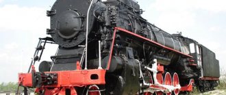
| 4200000295 | Local | — | Steam locomotive P36-0192 Steam locomotive "P36-0192" - a monument to the revolutionary, military, labor glory of the railway workers of the Taiga station | Near the railway depot | ||
| 4200000296 | Local | — | The grave of three sailors who were shot. The mass grave of three sailors who were shot. | 500 m from the last houses on Sovkhoznaya Street | ||
| 4200000297 | Local | — | Monument to the victims of political repression Monument to the victims of political repression | Kirova, 13 | ||
| 4200232000 | Local | — | Construction of a railway depot The building of a locomotive depot, where prominent party leader S. M. Kirov spoke | Taiga railway station |
How the city came into being
The city of Taiga is comfortably located in the north-west of Kuzbass. This small city is unique due to the history of its origin. This settlement arose during the construction of the Trans-Siberian Railway.
The builders of the railway line, which in the future was supposed to connect the central part of Russia with the Far East, discovered an “island” of stunted forest among the swampy swamps. And for people then there was an urgent need for a place for proper rest after exhausting work and storage of building materials in swamps and constant humidity. And the place, which later became a city, was ideally suited for this.
Initially, the city of Taiga had a different name. The first inhabitants of the then small settlement called this place Tomsk-Taiga Station. But with the increase in residents at the station, as well as the construction of the first houses and social facilities, the small settlement grew into the city of Taiga.
At that time, the place was ideal for installing a railway junction, but swampy from the point of view of construction work. Therefore, land reclamation workers had something to work on here. After all, for any construction work and laying a railway, the entire surrounding area had to be drained.
On the site of the future city of Taiga, the first settlements appeared at the end of the 19th century. The first buildings then were log houses and even just huts made of pine needles. A year later, the city of Taiga was officially recognized as a settlement that was part of the Tomsk province. Since 1925, the city was transferred to the subordination of the Novosibirsk region. And finally, since 1943, the city of Taiga became part of the new Kemerovo region.
Famous people of Taiga
Inna Vladimirovna Makarova was born in Taiga , and writer Vladimir Alekseevich Chivilikhin .
Gleb Maximilianovich Krzhizhanovsky in Taiga
In 1900-1901 at the station. Taiga worked as a figure in the revolutionary movement of Russia, Soviet state and party leader, scientist Gleb Maximilianovich Krzhizhanovsky (1872-1959). G. M. Krzhizhanovsky, together with his friend V. I. Lenin, participated in the creation of the St. Petersburg “Union of Struggle for the Liberation of the Working Class.” In 1895 he was arrested, and in 1897 he was exiled to Siberia for 3 years. Krzhizhanovsky spent most of his exile in the Minusinsk district (from 1898 - Minusinsk district) in the village. Tesinskoye (Tes) and the city of Minusinsk. Here he continued his revolutionary activities with Lenin, who was also serving exile in the Minusinsk district - in the village. Shushenskoye.
After the end of his exile, G. M. Krzhizhanovsky was forbidden to live in the largest cities of the Russian Empire, and he decided to stay in Siberia. At the station Taiga, he was offered the high position of assistant to the head of the Taiga section of the traction service - head of the depot with a significant salary for those times of 1800 rubles. in year. In March 1900, Krzhizhanovsky began his work. In Taiga, he, along with his wife Zinaida Pavlovna and mother Elvira Ernestovna, settled in a government apartment. Soon, Gleb Maximilianovich created a local Marxist cell. In September 1901, the Krzhizhanovsky couple went abroad for a while.
In 1920, G. M. Krzhizhanovsky was the chairman of the State Commission for Electrification of Russia (GOELRO), in 1921-1923 and 1925-1930 - chairman of the State Planning Committee, in 1929-1939 - vice-president of the USSR Academy of Sciences. Krzhizhanovsky is the author of the Russian text of a number of revolutionary songs, including “Varshavyanka” by V. I. Sventsitsky (known in adaptation as “Hostile whirlwinds are blowing over us”).
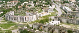
Taiga city today
The city of Taiga (Kemerovo region) received active development in the 70s of the last century. But the city felt its greatest peak of development on the eve of its 100th anniversary, namely in 1996.
Thus, the Taiga Railway Institute has been opened in the city today, which is rightfully considered one of the best in the country. The city of Taiga boasts a modern railway hospital and a House of Communications.
For the anniversary of the city of Taiga, a lot was done to improve it. Dilapidated housing in the central part was demolished. In general, housing construction was carried out on a special scale throughout the city. Particular attention was paid to greening the city.
Today, as before, the city-forming enterprises here are the enterprises of the railway department. And no matter what changes occur, the city of Taiga remains a large and important station on the Trans-Siberian Railway.
Population
| Population | |||||
| 1926[3] | 1931[3] | 1939[3] | 1959[4] | 1967[3] | 1970[5] |
| 10 900 | ↗15 500 | ↗29 100 | ↗33 860 | ↘29 000 | ↘26 895 |
| 1979[6] | 1989[7] | 1992[3] | 1996[3] | 1998[3] | 2001[3] |
| ↘25 248 | ↗26 233 | ↘25 900 | ↗27 400 | ↘26 200 | ↘26 000 |
| 2002[8] | 2003[3] | 2005[3] | 2006[3] | 2007[3] | 2008[9] |
| ↘24 726 | ↘24 700 | →24 700 | ↗24 800 | ↗24 900 | →24 900 |
| 2009[10] | 2010[11] | 2011[10] | 2012[12] | 2013[13] | 2014[14] |
| ↘24 880 | ↗25 331 | ↗25 357 | ↗25 489 | ↘25 481 | ↘25 122 |
| 2015[15] | 2016[1] | ||||
| ↘24 698 | ↘24 532 | ||||
City for tourists
Among tourists, one can hardly find the city of Taiga on the list of must-sees. But those who find themselves here are advised to visit the local station, the building of which was built before the revolution. A pedestal was installed on the territory of the railway station in 1954, as a memory of the exploits of railway workers, steam locomotive P36 -0192.
And although Taiga cannot boast of ancient artifacts or modern skyscrapers, this city can give tranquility and authenticity to everyone. In addition, the history of the city is closely intertwined with the great construction project of that time - the Trans-Siberian Railway.
Neighboring natural taiga zones in Russia
In the west, taiga massifs are located nearby broad-leaved thickets and mixed forest belts. In the northern side there is tundra and forest-tundra.
The taiga is surrounded by areas of high belts in the east. That is, mountains, plateaus, where the alternation of natural areas is disrupted. On the southern side, the neighbors are heterogeneous forest thickets.
Historical milestones
By the time the Kemerovo region was formed, the population of Taiga was slightly more than 30 thousand people. At that time, there were two functioning churches in the city, a railway workers’ club was opened, and a local newspaper was published. This became an important event, which the population of the city was proud of at that time.
Taiga and the city leadership were able to open the first hospital back in 1943. Over time, this hospital became one of the best in the region. In addition, several secondary schools were opened. In 1940, a railway school was inaugurated in Taiga.
Separately, it should be noted that about 5 thousand people left the city of Taiga for the front during the Second World War and only half of them returned. Today's Taiga residents remember the exploits of their fellow countrymen. The streets of the city are named after the heroes and participants of the Second World War; grateful descendants built a memorial to the Taiga residents who left and died in the war.
Notes
- ↑ 12
www.gks.ru/free_doc/doc_2016/bul_dr/mun_obr2016.rar Population of the Russian Federation by municipalities as of January 1, 2016 - Order of the Government of the Russian Federation of July 29, 2014 No. 1398-r “On approval of the list of single-industry towns”
- ↑ 123456789101112
www.MojGorod.ru/kemerovsk_obl/tajga/index.html People's encyclopedia “My City”. Taiga (city) - [demoscope.ru/weekly/ssp/rus59_reg2.php All-Union Population Census of 1959. The size of the urban population of the RSFSR, its territorial units, urban settlements and urban areas by gender] (Russian). Demoscope Weekly. Retrieved September 25, 2013. [www.webcitation.org/6GDOghWC9 Archived from the original on April 28, 2013].
- [demoscope.ru/weekly/ssp/rus70_reg2.php All-Union Population Census of 1970 The size of the urban population of the RSFSR, its territorial units, urban settlements and urban areas by gender.] (Russian). Demoscope Weekly. Retrieved September 25, 2013. [www.webcitation.org/6GDOiMstp Archived from the original on April 28, 2013].
- [demoscope.ru/weekly/ssp/rus79_reg2.php All-Union Population Census of 1979 The size of the urban population of the RSFSR, its territorial units, urban settlements and urban areas by gender.] (Russian). Demoscope Weekly. Retrieved September 25, 2013. [www.webcitation.org/6GDOjhZ5L Archived from the original on April 28, 2013].
- [demoscope.ru/weekly/ssp/rus89_reg2.php All-Union Population Census of 1989. Urban population]. [www.webcitation.org/617x0o0Pa Archived from the original on August 22, 2011].
- [www.perepis2002.ru/ct/doc/1_TOM_01_04.xls All-Russian Population Census 2002. Volume. 1, table 4. Population of Russia, federal districts, constituent entities of the Russian Federation, districts, urban settlements, rural settlements - regional centers and rural settlements with a population of 3 thousand or more]. [www.webcitation.org/65AdCU0q3 Archived from the original on February 3, 2012].
- [www.gks.ru/bgd/regl/b08_14t/IssWWW.exe/Stg/s/09-00.htm Cities of the Kemerovo region (number of inhabitants - estimate as of January 1, 2008, thousand people)]. Retrieved June 1, 2016. [www.webcitation.org/6hwJBGYKL Archived from the original on June 1, 2016].
- ↑ 12
www.gks.ru/dbscripts/munst/munst32/DBInet.cgi?pl=8112027 Kemerovo region. Estimated resident population as of January 1, 2009-2016 - [kemerovostat.gks.ru/wps/wcm/connect/rosstat_ts/kemerovostat/resources/ff43230040e572408ffeef367ccd0f13/1.6.pdf All-Russian Population Census 2010. Kemerovo region. 1.6. Population of urban districts, municipal districts, urban and rural settlements, urban settlements, rural settlements]. Retrieved July 26, 2014. [www.webcitation.org/6RMInOgkU Archived from the original on July 26, 2014].
- [www.gks.ru/free_doc/doc_2012/bul_dr/mun_obr2012.rar Population of the Russian Federation by municipalities. Table 35. Estimated resident population as of January 1, 2012]. Retrieved May 31, 2014. [www.webcitation.org/6PyOWbdMc Archived from the original on May 31, 2014].
- [www.gks.ru/free_doc/doc_2013/bul_dr/mun_obr2013.rar Population of the Russian Federation by municipalities as of January 1, 2013. - M.: Federal State Statistics Service Rosstat, 2013. - 528 p. (Table 33. Population of urban districts, municipal districts, urban and rural settlements, urban settlements, rural settlements)]. Retrieved November 16, 2013. [www.webcitation.org/6LAdCWSxH Archived from the original on November 16, 2013].
- [www.gks.ru/free_doc/doc_2014/bul_dr/mun_obr2014.rar Table 33. Population of the Russian Federation by municipalities as of January 1, 2014]. Retrieved August 2, 2014. [www.webcitation.org/6RWqP50QK Archived from the original on August 2, 2014].
- [www.gks.ru/free_doc/doc_2015/bul_dr/mun_obr2015.rar Population of the Russian Federation by municipalities as of January 1, 2015]. Retrieved August 6, 2015. [www.webcitation.org/6aaNzOlFO Archived from the original on August 6, 2015].
Story
It arose at the end of the 19th century in connection with the construction of the railway; it was originally called “Tomsk-Taiga”. The station was opened in 1896.
The pioneers saw here a huge swampy space, small stunted forest, clay soil, and poor sources of water supply. But, despite this, according to the plan, which envisaged a branch in this place to the provincial center of the city of Tomsk, construction of a large railway junction began. By the time the line to Tomsk began moving in 1896, the first depot building had already been built here. At first it was called the village of Taezhny. And when a station, a depot, a church in the name of Andrei of Crete 1898 and the Prophet-Ilyinsky 1906, a Roman Catholic church, a synagogue, three cemeteries, a post office, a school and the population reached 10,000 people were built in the village, the village became the town of Taiga in the Tomsk province. In 1911 Taiga received city status.
Since a lot of water was needed to supply steam locomotives with water, at first they tried to extract it using wells and supply it to the pumps through standard water towers. But over time, there was a catastrophic shortage of water and it was necessary to build a water pipeline from the Yaya River, where a dam and a pumping station were built.
Currently, the station building is located so that the railway tracks go around it on both sides. Now it is a large railway junction, where a locomotive and carriage depot, a railway school, and a branch of the Omsk Institute of Railway Transport Engineers are located.
Location of taiga on the map of Russia
The taiga of Russia (photo maps of natural zones can be seen later in the article), which is characterized by different climatic zones, is located in a moderate humid climate. Coniferous trees form the basis of its plant life.
There are many swamps in forests of this type. They mainly cover the lands of northern Siberia, as well as mainland Canada.
The border of taiga forests begins approximately from St. Petersburg.
Passes through the cities:
- Yaroslavl;
- Nizhny Novgorod;
- Pskov;
- Ekaterinburg;
- Tomsk;
- Chita;
- Komsomolsk-on-Amur.
Green areas cover a significant area of the entire Siberian Plain and are also located in the Far East. They cover the Ural, Sayan and Altai mountains. As well as the highlands of the Baikal region, Sikhote-Alin, Greater Khingan. This climatic taiga zone is the longest on Earth. Its length is more than 7000 km from west to east.
The taiga is divided according to the nature of vegetation into 3 subzones in the direction from south to north:
| South | It is distinguished by a rich variety of flora and fauna. There are small-leaved and broad-leaved tree types. The climatic conditions are warm. Summer is hot and lasts about 4 months. Swampiness is low. |
| Average | Its peculiarity is moderate weather. The region experiences warm summers. Winter is harsh, but not frosty. There are many swamps of different types in the taiga. Because of this, the area is characterized by high moisture. Mostly spruce forests and blueberry bushes are common. |
| Northern | It is characterized by harsh winters, cold weather, and cool summers. Spruces and low pines growing sparsely reign here. |