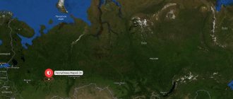
Republic of Mari El on the map of Russia
The capital is the city of Yoshkar-Ola, the republic borders the Kirov region in the north and east, the Nizhny Novgorod region in the west, the border with the Chuvash Republic in the southwest, and the Republic of Tatarstan in the southeast.
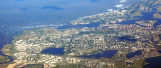
Mari-El is located in the middle reaches of the Volga River, in the east of the East European Plain. Its main territory is located on the left bank of the Volga, on the right bank there is only part of the Gornomariysky district, one of 14 districts, they can be seen on the map.
Districts on the map:
The area of the republic is about 23,375 square meters. kilometers, the population as of July 31, 2022 is about 685 thousand people.
In the capital, the city of Yoshkar-Ola, and throughout the territory, Moscow time is the same as in Moscow, the capital of Russia.
Choose and book interesting excursions in Yoshkar-Ola and get new travel experiences!
Administrative division of Mari El
The map clearly shows that within the republic there are:
- 3 cities of republican significance - Yoshkar-Ola, Volzhsk, Kozmodemyansk.
- 1 city of regional significance – Zvenigovo.
- 15 urban-type settlements.
- 1597 rural settlements (according to 2010 data) - villages, hamlets, hamlets, settlements.
In addition to populated areas, the territory of Mari El includes 14 districts and 105 rural districts. Local self-government is carried out by 138 municipalities.
A little history
The Mari Autonomous Region was formed on November 4, 1920, and on December 5, 1936 it became known as the Mari Autonomous Republic. Since October 22, 1990 - the Mari Soviet Socialist Republic (MSSR) as part of the RSFSR.
The modern name of the republic: Mari Republic - Mari El since December 9, 1992, legalized and came into force on January 12, 1993 from the moment of publication of the Law of the Russian Federation.
This is a multinational republic, national holidays of the Mari people are celebrated here, as well as Russian, Chuvash, Tatar holidays, and many festivals are held every year.
You can read about the sights and rich nature of Mari El on this page
My friends vacationed here and shared some of their photographs and memories of their vacation in Mari El in the summer in the Mari open spaces, among the rich and generous nature. They also attended one of the holidays - Benderiad, which is fun and interesting every summer.
Map of Mari El with cities, regions and villages
| 1. Yoshkar-Ola | 6. Paranga town (Paranginsky district) | 11. Kuzhener town (Kuzhenersky district) | 16. Krasnogorsk town (Zvenigovsky district) |
| 2. New Toryal town (Novo Toryal district) | 7. Yurino town (Yurinsky district) | 12. Kozmodemyansk (Gornomariysky district) | 17. Suslonger town (Zvenigovsky district) |
| 3. Morki town (Morkinsky district) | 8. Sovetsky town (Sovetsky district) | 13. Privolzhsky town (Volzhsky district) | 18. Mochalische town (Zvenigovsky district) |
| 4. Medvedevo rp (Medvedevsky district) | 9. Sernur town (Sernur district) | 14. Volzhsk city (Volzhsky district) | 19. Kilemary town (Kilemary district) |
| 5. Orshanka town (Orsha district) | 10. Mari-Turek town (Mari-Turek district) | 15. Zvenigovo city (Zvenigovo district) |
Satellite map of Mari El
Switching between the satellite map of Mari El and the schematic map is done in the lower left corner of the interactive map.
Republic of Mari El - Wikipedia:
Date of foundation of Mari El:
November 4, 1920
Population of Mari El:
675,332 people.
(January 1, 2022) Telephone code of Mari El:
836
Area of Mari El:
23,375 km²
Vehicle code of Mari El:
12
Districts of Mari El:
Volzhsky • Gornomariysky • Zvenigovsky • Kilemarsky • Kuzhenersky • Mari-Tureksky • Medvedevsky • Morkinsky • Novotoryalsky • Orsha • Paranginsky • Sernursky • Sovetsky • Yurinsky.
Cities of Mari El - list of cities in alphabetical order:
Population of Mari El cities in 2022.
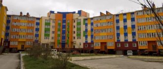
Volzhsk city
founded in 1940.
The population of the city is 54,519 people. The city of Zvenigovo
was founded in 1860.
The population of the city is 11,379 people. The city of Yoshkar-Ola
was founded in 1584.
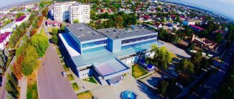
The population of the city is 266,675 people. The city of Kozmodemyansk
was founded in 1583. The population of the city is 20,327 people.
Mari El Republic
located in the eastern part of European Russia between the Kirov and Nizhny Novgorod regions and the Republics of Tatarstan and Chuvashia.
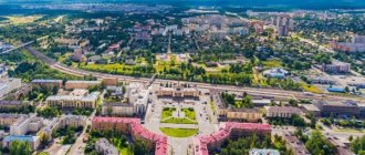
The capital of the republic, the city of Yoshkar-Ola,
boasts a new Kremlin and many new and unusual monuments. The Volga flows through the territory of the republic, dividing the region into two parts.
The Republic of Mari El has many interesting sights, such as the city of Kozmodemyansk
, which is believed to have served as the prototype for Vasyukov in the famous novel by Ilf and Petrov “The Twelve Chairs”. Not far from the city there is an open-air ethnographic museum with traditional Mari buildings. In the city of Yurino there is a medieval castle from the 19th century, built by Count Sheremtiev, which today houses a museum.
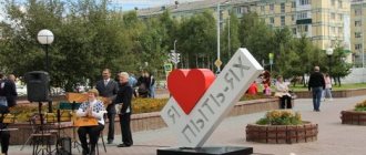
Yoshkar-Ola
in the local Mari language it is translated as Red City. Previously it was known as Tsarevokokshaysk from the words Tsar and Kokoshaga (the name of the local river), and then Krasnokokshaysk, from the word red. This is a small and cozy city, unique in that the entire quarter was rebuilt in a special style, including local national motifs mixed with elements of Venetian and Moorish architecture.
What to see in Mari El
The attractions of the Mari El Republic include nature reserves, national parks, forests and other untouched areas. The two largest national parks of Mari El are Malaya Chodra and Bolshaya Kokshaga. The first is a popular tourist area with a large number of boarding houses and sanatoriums located on the shores of Lake Yalchik.
Bolshaya Kokshaga is the abode of the rarest representatives of the animal and plant world. Despite the fact that the main wealth of the republic is nature, Mari El also has architectural monuments, such as the Sheremetyev Castle, which has no analogues in the world.
Republic of Mari El photo
My native country is wide...
The harvest is ripening in the fields:
It’s good to take a ride through the vast expanses and see the ancient beauty that is carefully preserved here.
Beautiful rustic windows with carved frames:
Cathedral of the Smolensk Icon of the Mother of God in the city of Kozmodemyansk, the center of the Gornomariysky district:
Marie-El
Stamp "50 years of the Mari Autonomous Soviet Socialist Republic".
USSR Post 1970 Main article: History of Mari El
The Bronze Age is represented in the Mari region by the Ust-Vetluzhsky burial ground, which belongs to the Seima-Turbino phenomenon and reflects the migrations of Indo-European peoples.
Finno-Ugric tribes have inhabited the territory of the modern European part of Russia since prehistoric times. On the territory of the Mari El Republic, archaeological sources dating back to the first millennium BC have been preserved. e. Since the Mari writing - Tiste was used exclusively for recording economic information, and Tatar written sources were destroyed during the capture of Kazan, almost all written information about the history of the middle Volga is associated with Russian sources.
The Cheremis (the modern name is the Mari) were first reliably mentioned in the 10th century in a letter from the Khazar king Joseph to the dignitary of the Cordoba caliph Hasdai ibn Shafrut. The ancestors of modern Mari, between the 5th and 8th centuries, interacted with the Goths, later with the Khazars and Volga Bulgaria, which was located on the territory of modern Tatarstan and was destroyed in 1236 by the Mongol troops of Batu Khan advancing on Rus'. The Mari, apparently, were in allied relations with the Golden Horde that formed after this. From the 13th to the 16th centuries, the Mari were part of the Golden Horde and the Kazan Khanate.
From the 9th century, the Mari came into contact with the Slavic and Slavo-Finnish population moving eastward, who founded the cities of Rostov, Galich, Yaroslavl, Suzdal, Vladimir and in 1221 Nizhny Novgorod. Thus, the Mari fell into the sphere of influence of Kievan Rus. Gradually, after accepting Christianity, the Western Mari became glorified; those who did not want to accept Christianity fled to the east. In the Middle Ages, Russian-Tatar clashes on the Mari lands became commonplace[13]. In 1551, the lands of the mountain Mari (the right bank of the Volga) came under the control of the Russian kingdom, and in 1552, tsarist troops took Kazan, and the meadow Mari began to pay tribute to the Russian kingdom. A 30-year period of Cheremis wars began, which ended with the construction of fortified cities for the permanent maintenance of military garrisons (Kozmodemyansk was founded in 1583, Tsarevokokshaysk in 1584 - now Yoshkar-Ola, Yaransk, Sanchursk) and the subsequent settlement of the region by Russians.
Forced Christianization led the Mari to flee into the forests, leaving entire villages empty. Under Peter I, the Mari began to be drafted into the army, and the Tarkhan class was abolished. Along with this, scientific exploration of the territory began, and the first written monuments of the Mari language in Cyrillic appeared. The first Mari grammar of Putsek-Grigorovich appeared in 1775. The situation of the Mari remained quite difficult, and in 1775 they massively supported Pugachev’s uprising.
In 1872, the Kazan Teachers' Seminary was opened, one of the tasks of which was to educate representatives of the Volga peoples, including the Mari. This gave a serious impetus to the development of education and culture (including national) in the region.
Before the October Revolution, the Mari (like the majority of the peoples of Russia) did not have their own statehood and were scattered among the Kazan, Vyatka, Kostroma, Nizhny Novgorod, Ufa and Perm provinces. And today, out of 670 thousand Mari, only 324.3 thousand live in the Republic of Mari El. Historically, 51.7% of Mari live outside the borders of their republic, including 4.1% outside Russia.
After the October Revolution, on November 4, 1920, the Mari Autonomous Region was formed. In 1922, the region suffered greatly from the famine that swept the Volga region. In May 1922, in the Mari Autonomous Region, according to official data, 466,486 people (of which 164,429 were children) were listed as starving [14].
In the 1920s, two equal linguistic literary norms were established: the Meadow Mari language and the Mountain Mari language. These years, as in other national republics, were marked by the active development of national and cultural construction.
On July 15, 1929, the Mari Autonomous Region became part of the newly formed Nizhny Novgorod (from 1932 - Gorky) region. On December 5, 1936, the Gorky Territory was abolished, the Mari Autonomous Region was transformed into the Mari Autonomous Soviet Socialist Republic, directly included in the RSFSR[15].
October 22, 1990 - Mari Soviet Socialist Republic (MSSR), without leaving the RSFSR. December 9, 1992 - Republic of Mari El[16] (the amendment to the Law came into force upon publication in Rossiyskaya Gazeta on January 12, 1993[17]). The name is based on the ethnic self-name of its indigenous population - Mari
(“man, husband”)
Mari
“Mari, Mari, Mari”,
el
“country, region”.
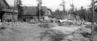
In 1936, it was decided to build a pulp and paper mill on the territory of the republic, designed to ensure import substitution of manufactured goods. An all-Union construction project was announced on the territory of the Lopatinsky backwater. On August 26, 1939, by decision of the Supreme Council of the RSFSR, the Lopatinsky district was created with a regional center in the village of Lopatino at the pulp and paper mill under construction. In 1940, the village was renamed Volzhsk and given the status of a city. In connection with the renaming, the district was also renamed Volzhsky District. The construction of machine-building enterprises gave impetus to the development of Volzhsk, which soon became a major industrial center along with Yoshkar-Ola.
During the war, over 130 thousand people were called up to the front. A little more than 56 thousand people returned home. Workers evacuated from the western regions of the USSR were accommodated and employed on the territory of the republic. Enterprises relocated from Moscow, Leningrad, Odessa and other cities came into operation in the republic. A number of research institutions in Leningrad were transferred to Yoshkar-Ola. During the post-war five-year plans, new large enterprises in the machine-building, instrument-making and other industries arose in the republic.
1972 - opening of the first university on the territory of the republic (Mari State University - MarSU).
In October 1990, the Declaration of State Sovereignty was adopted, since 1992 the modern name is the Mari Republic (Mari El).
1995 - transformation of the Mari Polytechnic Institute (MPI) into the Mari State Technical University (in 2012 it was transformed into the university complex Volga State Technological University - PSTU).
In the 2000s, in the capital of the republic, the city of Yoshkar-Ola, many cultural objects were built and reconstructed, such as the Tsarevokokshay Kremlin, the embankment, Arkhangelskaya Sloboda, Chavaina Boulevard, Victory Boulevard, etc.
Holidays in Mari El
Many festivals and holidays are held in cities and the capital Yoshkar-Ola at different times of the year. In the summer in June, the republican national holiday Peledysh payrem - translated from Mari as the Flower Festival, during which the results of spring field work are summed up and mass festivities take place throughout the Mari region.
The interregional folklore and ethnographic holiday Land of Ancestors is held in July in the village of Arda, Kilemar region. the Baranka music festival takes place in the city of Volzhsk in memory of the famous musician.
Are you going on a trip or vacation?
Here it is convenient and profitable to purchase tickets for your trip!
We will visit the Benderiad Festival of Satire and Humor , which has been celebrated since 1995. The center of the festival is the city of Kozmodemyansk, people with a good sense of humor and a wonderful mood come here from everywhere. A carnival procession takes place through the streets of Kozmodemyansk. An auction of “12 chairs” is held on Market Square, where you can buy a “chair with diamonds”; a chess tournament is certainly held. There are performances by comedians, music concerts, and discos throughout the city.
One of the main participants of Benderiada:
Cities[ | ]
| № | Name | municipal district / urban district | population (persons) | founding/first mention | city status | coat of arms | former names |
| 1 | Yoshkar-Ola | Yoshkar-Ola | ↗276 155[4] | 1584 | 1781 | until 1919 - Tsarevokokshaysk until 1928 - Krasnokokshaysk | |
| 2 | Volzhsk | Volzhsk | ↘52 703[4] | 19th century | 1940 | until 1938 - Lopatino | |
| 3 | Zvenigovo | Zvenigovsky district | ↗10 966[4] | 1860 | 1974 | Chekury, Zvenizhsky | |
| 4 | Kozmodemyansk | Kozmodemyansk | ↘19 970[4] | 1583 | 1781 |
Festival of satire and humor Benderiad in Kozmodemyansk
There is a lot of entertainment for children on the Market Square of Kozmodemyansk:
A large, elegant Children's Town for the delight of children:
Ostap Bender's performance in the festive humor:
The festival continues on the banks of the Volga - yachts and parachutists take part in the celebration:
I suggest you watch a cool movie: